Bickmarsh

Civil Parish in Warwickshire Wychavon

England

Bickmarsh

Buildings and machinery,  Clink Farm Cottages,  Bickmarsh
Buildings and machinery, Clink Farm Cottages, Bickmarsh Credit: Liz Stone

Bickmarsh is a civil parish located in the county of Warwickshire, England. Situated approximately 3 miles southeast of the town of Alcester, Bickmarsh covers an area of about 1.32 square miles. The parish is predominantly rural, with a sparse population of around 200 residents.

The landscape of Bickmarsh is characterized by rolling hills and picturesque countryside, providing a peaceful and idyllic setting. The parish is surrounded by farmland and meadows, with scattered residential properties and farmhouses dotted throughout.

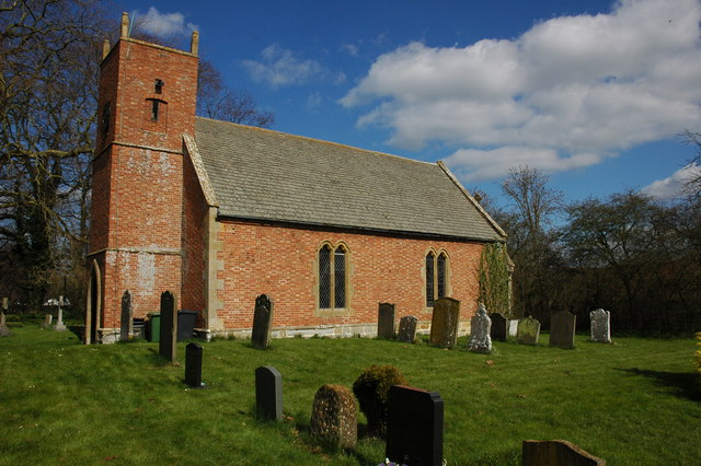
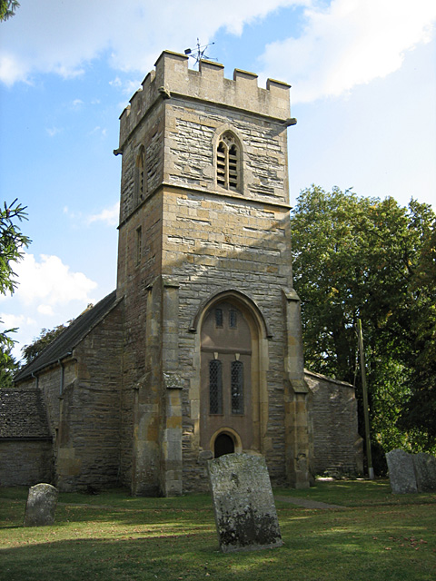
Despite its small size, Bickmarsh boasts a rich history. The village is believed to have been established in medieval times, evidenced by the presence of several historical buildings, including a 13th-century church dedicated to St. Leonard. The church is a prominent feature of the parish and serves as a focal point for the local community.

Bickmarsh offers a tranquil lifestyle, away from the hustle and bustle of urban areas. The village provides a close-knit community atmosphere, with residents enjoying a sense of peace and quiet. The surrounding countryside also offers ample opportunities for outdoor activities such as walking, hiking, and exploring nature.

While Bickmarsh may be small in size, its charm and beauty make it an attractive place to reside or visit for those seeking a peaceful rural retreat.

If you have any feedback on the listing, please let us know in the comments section below.

Bickmarsh Images

Images are sourced within 2km of 52.137802/-1.839331 or Grid Reference SP1148. Thanks to Geograph Open Source API. All images are credited.

Buildings and machinery,  Clink Farm Cottages,  Bickmarsh
Buildings and machinery, Clink Farm Cottages, Bickmarsh
Buckle Street View north along Buckle Street, Ullington.
Buckle Street
View north along Buckle Street, Ullington.
Stubble field west of Buckle Street A stubble field taken through a field entrance off Buckle Street.
Stubble field west of Buckle Street
A stubble field taken through a field entrance off Buckle Street.
View towards the Gliding Club View north west from a field entrance off Buckle Street, across a partly ploughed stubble field, towards the distant gliders at the Gliding Club.
View towards the Gliding Club
View north west from a field entrance off Buckle Street, across a partly ploughed stubble field, towards the distant gliders at the Gliding Club.
View towards Bickmarsh Hall Looking north west from the bridleway from Buckle Street to Dorsington.
View towards Bickmarsh Hall
Looking north west from the bridleway from Buckle Street to Dorsington.
Bridleway to Dorsington View ENE along the bridleway from Buckle Street to Dorsington, which coincides with a gravelled farm track for this section.
Bridleway to Dorsington
View ENE along the bridleway from Buckle Street to Dorsington, which coincides with a gravelled farm track for this section.
Gate number 99 View south west on the footpath from Crabtree Farm.
All the gates in this area have numbers on them.
Gate number 99
View south west on the footpath from Crabtree Farm. All the gates in this area have numbers on them.
View north west from the footpath to Crabtree Farm Looking north west across a recently ploughed stubble field.
The farm buildings near Bickmarsh Hall can be seen in the distance.
View north west from the footpath to Crabtree Farm
Looking north west across a recently ploughed stubble field. The farm buildings near Bickmarsh Hall can be seen in the distance.
Outbuildings at Crabtree Farm View east from the public footpath running through the farm.
Outbuildings at Crabtree Farm
View east from the public footpath running through the farm.
Footpath through fields near Crabtree Farm Looking WSW along the route of a footpath across the field.
Footpath through fields near Crabtree Farm
Looking WSW along the route of a footpath across the field.
Beck's Wood, Heart of England Forest This area of native forest planted in 2010 is part of the Heart of England Forest Project.<span class="nowrap"><a title="https://www.heartofenglandforest.com/" rel="nofollow ugc noopener" href="https://www.heartofenglandforest.com/">Link</a><img style="margin-left:2px;" alt="External link" title="External link - shift click to open in new window" src="https://s1.geograph.org.uk/img/external.png" width="10" height="10"/></span>
"to plant and preserve a large native forest in the heart of England"
Taken from the footpath to Crabtree Farm.
Beck's Wood, Heart of England Forest
This area of native forest planted in 2010 is part of the Heart of England Forest Project.LinkExternal link "to plant and preserve a large native forest in the heart of England" Taken from the footpath to Crabtree Farm.
View from the bench A lone bench beside the footpath to Crabtree Farm looks to the south across Beck's Wood, a recently planted area of native forest as part of the Heart of England Forest Project.<span class="nowrap"><a title="https://www.heartofenglandforest.com/" rel="nofollow ugc noopener" href="https://www.heartofenglandforest.com/">Link</a><img style="margin-left:2px;" alt="External link" title="External link - shift click to open in new window" src="https://s1.geograph.org.uk/img/external.png" width="10" height="10"/></span>.
View from the bench
A lone bench beside the footpath to Crabtree Farm looks to the south across Beck's Wood, a recently planted area of native forest as part of the Heart of England Forest Project.LinkExternal link.
Footbridge over a stream Footbridge on the footpath to Crabtree Farm.
Footbridge over a stream
Footbridge on the footpath to Crabtree Farm.
Alternative footpath route The route of the footpath as marked on the map goes tight round an isolated dwelling. This more direct route has been provided south of the small stream.
Alternative footpath route
The route of the footpath as marked on the map goes tight round an isolated dwelling. This more direct route has been provided south of the small stream.
Vast stubble field View southwest across a vast field with a huge sky.
Vast stubble field
View southwest across a vast field with a huge sky.
Footpath to Little Dorsington The footpath at this point is tightly constrained by the fence, which makes navigating round overgrowing bushes quite tricky.
Footpath to Little Dorsington
The footpath at this point is tightly constrained by the fence, which makes navigating round overgrowing bushes quite tricky.
Bracket fungi on Horse Chestnut tree (Top view) A Horse Chestnut tree by the side of Buckle Street, with two very large bracket fungi.
For bottom view see <a href="https://www.geograph.org.uk/photo/5090236">SP1147 : Bracket fungi on Horse Chestnut tree (Bottom view)</a>
Bracket fungi on Horse Chestnut tree (Top view)
A Horse Chestnut tree by the side of Buckle Street, with two very large bracket fungi. For bottom view see SP1147 : Bracket fungi on Horse Chestnut tree (Bottom view)
Show me another place!

Bickmarsh is located at Grid Ref: SP1148 (Lat: 52.137802, Lng: -1.839331)

Administrative County: Worcestershire

District: Wychavon

Police Authority: West Mercia

What 3 Words

///general.marinated.biggest. Near Bidford-on-avon, Warwickshire

Nearby Locations

Bickmarsh

Related Wikis

Bickmarsh

Bickmarsh is a village and civil parish in the Wychavon district of Worcestershire, England. According to the 2001 census it had a population of 65....

Dorsington

Dorsington is a village and civil parish in the Stratford-on-Avon district, in the county of Warwickshire, England. Dorsington was in Gloucestershire until...

Littleton F.C.

Littleton Football Club is a football club based in North and Middle Littleton, near Evesham, Worcestershire. They are members of the Midland League Division...

Cleeve Prior

Cleeve Prior is a village in the Vale of Evesham Worcestershire, England. It is situated five miles north-east of Evesham. There are many picturesque houses...

Heart of England Forest

The Heart of England Forest is a charitable organisation in England, focussed on the conservation and restoration of native woodland in Warwickshire and...

Barton, Warwickshire

Barton is a village in Warwickshire, England, on the river Avon, near Bidford-on-Avon. It forms part of the civil parish of Bidford-on-Avon. The name...

Pebworth

Pebworth is a village and civil parish in the county of Worcestershire, lying about 5 miles north-north-west of the town of Chipping Campden in Gloucestershire...
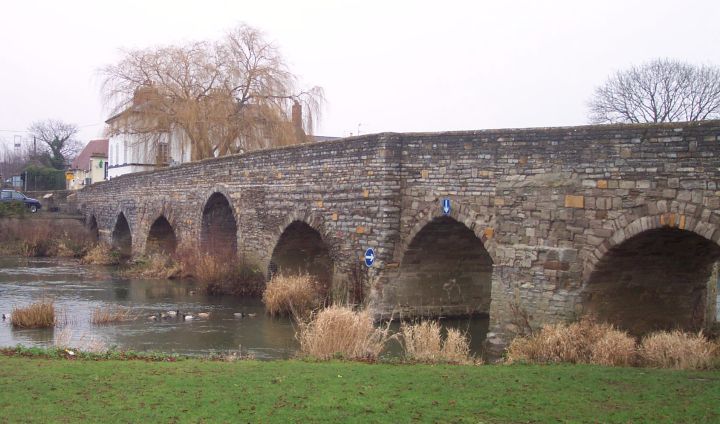
Bidford Bridge

Bidford Bridge crosses the Avon at Bidford-on-Avon, Warwickshire, England. It is a scheduled monument and is Grade I listed. The bridge is wider than a...

Have you been to Bickmarsh?

Leave your review of Bickmarsh below (or comments, questions and feedback).