Berrow
Civil Parish in Somerset Sedgemoor
England
Berrow

Berrow is a civil parish located in the county of Somerset, England. It is situated on the northern coast of the county, and is bordered by the Bristol Channel to the west. The parish covers an area of approximately 15 square miles.
The village of Berrow itself is a small coastal settlement with a population of around 1,300 people. It is primarily a residential area, with a mix of traditional cottages and modern houses. The village has a central green space, known as Berrow Village Green, which is a popular spot for locals to relax and enjoy outdoor activities.
One of the main attractions in Berrow is its beach, which stretches for several miles along the coastline. The beach is known for its sandy dunes and is a popular destination for tourists, especially during the summer months. It is also a designated Site of Special Scientific Interest, as it is home to a variety of rare plants and wildlife.
Berrow is also home to a golf course, Berrow Links Golf Club, which is renowned for its challenging course and stunning coastal views. The club attracts golfers from all over the country and has hosted several professional tournaments in the past.
Overall, Berrow is a picturesque coastal village with a strong sense of community. It offers a range of amenities and attractions, making it an attractive place to live or visit.
If you have any feedback on the listing, please let us know in the comments section below.
Berrow Images
Images are sourced within 2km of 51.268854/-3.029023 or Grid Reference ST2852. Thanks to Geograph Open Source API. All images are credited.


Berrow is located at Grid Ref: ST2852 (Lat: 51.268854, Lng: -3.029023)
Administrative County: Somerset
District: Sedgemoor
Police Authority: Avon and Somerset
What 3 Words
///mocked.fancy.grove. Near Burnham-on-Sea, Somerset
Nearby Locations
Related Wikis

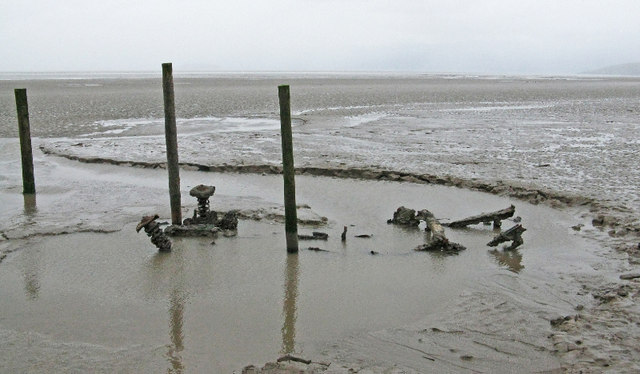
Nornen
The Nornen was a large sailing vessel of the barque type. The three masts were typical of barque ships; the foremast and mainmast square-rigged and the...

Berrow, Somerset
Berrow is a small residential coastal village and holiday area, a civil parish in Somerset, England, situated in between Burnham-on-Sea and Brean. According...

Brean Leisure Park
Brean Leisure Park is an amusement park in the coastal resort of Brean, near Burnham-on-Sea, Somerset, England. The park covers an area of 200 acres (80...

Bulldog Coaster (Brean Leisure Park)
Bulldog Coaster, formerly named Shock Wave or Crazy Loop is a roller coaster at Brean Leisure Park in Brean, Somerset, England. The ride, which was manufactured...
Nearby Amenities
Located within 500m of 51.268854,-3.029023Have you been to Berrow?
Leave your review of Berrow below (or comments, questions and feedback).