Beckley and Stowood

Civil Parish in Oxfordshire South Oxfordshire

England

Beckley and Stowood

Oxford transmitting station, Beckley A television and radio station.
Oxford transmitting station, Beckley Credit: Robin Webster

Beckley and Stowood is a civil parish located in the county of Oxfordshire, England. Situated about 6 miles northeast of the historic city of Oxford, the parish encompasses the villages of Beckley and Stowood.

Beckley, the larger of the two villages, is nestled in the rolling countryside of the Oxfordshire Cotswolds. It is characterized by its picturesque thatched cottages, charming countryside views, and a sense of tranquility. The village is home to a close-knit community, with several community events and activities taking place throughout the year. It boasts a village hall, a primary school, a village shop, and a traditional pub, providing essential amenities for its residents.

Stowood, on the other hand, is a smaller village located to the east of Beckley. It is known for its beautiful rural setting, with open fields and woodlands surrounding the area. The village is primarily residential, offering a peaceful and idyllic environment for its inhabitants.

Both villages benefit from their proximity to Oxford, allowing residents to enjoy the amenities and cultural offerings of the city while still enjoying the tranquility of village life. The area also offers ample opportunities for outdoor activities, with scenic walking and cycling routes nearby.

Overall, Beckley and Stowood offer a charming and picturesque living environment, combining the beauty of the countryside with the convenience of nearby urban amenities.

If you have any feedback on the listing, please let us know in the comments section below.

Beckley and Stowood Images

Images are sourced within 2km of 51.794237/-1.18319 or Grid Reference SP5610. Thanks to Geograph Open Source API. All images are credited.

Oxford transmitting station, Beckley A television and radio station.
Oxford transmitting station, Beckley
A television and radio station.
The Closes, RSPB Otmoor An area of wet grassland. Ot Moor was first drained in 1816 and had been divided up into fields by 1830. Since 1997 the RSPB have been recreating wetlands here.
The Closes, RSPB Otmoor
An area of wet grassland. Ot Moor was first drained in 1816 and had been divided up into fields by 1830. Since 1997 the RSPB have been recreating wetlands here.
Managed land, RSPB Otmoor A lot of shrubs have been cut down to ground level.
Managed land, RSPB Otmoor
A lot of shrubs have been cut down to ground level.
No entry to a conservation area, RSPB Otmoor Ot Moor was first drained in 1816 and had been divided up into fields by 1830. Since 1997 the RSPB have been recreating wetlands here.
No entry to a conservation area, RSPB Otmoor
Ot Moor was first drained in 1816 and had been divided up into fields by 1830. Since 1997 the RSPB have been recreating wetlands here.
Bench with a view of Moorleys, RSPB Otmoor Ot Moor was first drained in 1816 and had been divided up into fields by 1830. Since 1997 the RSPB have been recreating wetlands here.
Bench with a view of Moorleys, RSPB Otmoor
Ot Moor was first drained in 1816 and had been divided up into fields by 1830. Since 1997 the RSPB have been recreating wetlands here.
Screened permissive path, RSPB Otmoor Close to the Wetlands Watch building. Ot Moor was first drained in 1816 and had been divided up into fields by 1830. Since 1997 the RSPB have been recreating wetlands here.
Screened permissive path, RSPB Otmoor
Close to the Wetlands Watch building. Ot Moor was first drained in 1816 and had been divided up into fields by 1830. Since 1997 the RSPB have been recreating wetlands here.
Ashgrave, west from the Wetlands Watch, RSPB Otmoor Ot Moor was first drained in 1816 and had been divided up into fields by 1830. Since 1997 the RSPB have been recreating wetlands here.
Ashgrave, west from the Wetlands Watch, RSPB Otmoor
Ot Moor was first drained in 1816 and had been divided up into fields by 1830. Since 1997 the RSPB have been recreating wetlands here.
Ashgrave, north from the Wetlands Watch, RSPB Otmoor Ot Moor was first drained in 1816 and had been divided up into fields by 1830. Since 1997 the RSPB have been recreating wetlands here.
Ashgrave, north from the Wetlands Watch, RSPB Otmoor
Ot Moor was first drained in 1816 and had been divided up into fields by 1830. Since 1997 the RSPB have been recreating wetlands here.
Ashgrave, south from the Wetlands Watch, RSPB Otmoor Ot Moor was first drained in 1816 and had been divided up into fields by 1830. Since 1997 the RSPB have been recreating wetlands here.
Ashgrave, south from the Wetlands Watch, RSPB Otmoor
Ot Moor was first drained in 1816 and had been divided up into fields by 1830. Since 1997 the RSPB have been recreating wetlands here.
Screened path from the Wetlands Watch, RSPB Otmoor Ot Moor was first drained in 1816 and had been divided up into fields by 1830. Since 1997 the RSPB have been recreating wetlands here.
Screened path from the Wetlands Watch, RSPB Otmoor
Ot Moor was first drained in 1816 and had been divided up into fields by 1830. Since 1997 the RSPB have been recreating wetlands here.
Bridleway on the route of a Roman road, near RSPB Otmoor Looking north.
Bridleway on the route of a Roman road, near RSPB Otmoor
Looking north.
Woodperry Manor
Woodperry Manor
Folly Farm
Folly Farm
Beckley
Beckley
Assumption of the Blessed Virgin Mary Church, Beckley
Roman road near Beckley The roman road across Otmoor is a bridleway. This section is between the RSPB reserve and the military firing range.
Roman road near Beckley
The roman road across Otmoor is a bridleway. This section is between the RSPB reserve and the military firing range.
Bulrushes, ditch and marsh on Otmoor View from bridleway, which is also the RSPB visitor trail. The Royal Society for the Protection of Birds (RSPB) are converting this area back from drained arable land to grazing marsh and reedbed with ditches and pools.
Bulrushes, ditch and marsh on Otmoor
View from bridleway, which is also the RSPB visitor trail. The Royal Society for the Protection of Birds (RSPB) are converting this area back from drained arable land to grazing marsh and reedbed with ditches and pools.
Azure damselflies in tandem on Otmoor "They are Azure Damselflies (Coenagrion puella), which are very similar to Common Blue and also very common. The main difference is the shape of the marking at the top of the abdomen (just under the wing bases). In Azure this is 'rugby post' shaped whereas Common Blue has a club-shaped mark (most blue damselfly species differ mostly by their markings in this area). Another difference, also shown in the photo, is the black marks on the side of the thorax (going down from the wing bases) which are absent on Common Blue." This quote is from Hugh Venables, who identified these dragonflies. My photo <a href="https://www.geograph.org.uk/photo/182148">SP5612 : Rose bush and RSPB visitor trail on Otmoor</a> shows the dogrose bush they were on, and <a href="https://www.geograph.org.uk/photo/181456">SP5612 : Bulrushes, ditch and marsh on Otmoor</a> shows the drainage ditch near them on the RSPB Otmoor reserve.
See Open University nature trail web pages  <span class="nowrap"><a title="http://www.open.ac.uk/Nature_Trail/DFsex.htm" rel="nofollow ugc noopener" href="http://www.open.ac.uk/Nature_Trail/DFsex.htm">Link</a><img style="margin-left:2px;" alt="External link" title="External link - shift click to open in new window" src="https://s1.geograph.org.uk/img/external.png" width="10" height="10"/></span> for an explanation of how this mating of dragonflies works.
Azure damselflies in tandem on Otmoor
"They are Azure Damselflies (Coenagrion puella), which are very similar to Common Blue and also very common. The main difference is the shape of the marking at the top of the abdomen (just under the wing bases). In Azure this is 'rugby post' shaped whereas Common Blue has a club-shaped mark (most blue damselfly species differ mostly by their markings in this area). Another difference, also shown in the photo, is the black marks on the side of the thorax (going down from the wing bases) which are absent on Common Blue." This quote is from Hugh Venables, who identified these dragonflies. My photo SP5612 : Rose bush and RSPB visitor trail on Otmoor shows the dogrose bush they were on, and SP5612 : Bulrushes, ditch and marsh on Otmoor shows the drainage ditch near them on the RSPB Otmoor reserve. See Open University nature trail web pages LinkExternal link for an explanation of how this mating of dragonflies works.
Show me another place!

Beckley and Stowood is located at Grid Ref: SP5610 (Lat: 51.794237, Lng: -1.18319)

Administrative County: Oxfordshire

District: South Oxfordshire

Police Authority: Thames Valley

What 3 Words

///user.defeated.princely. Near Wheatley, Oxfordshire

Nearby Locations

Beckley and Stowood

Related Wikis

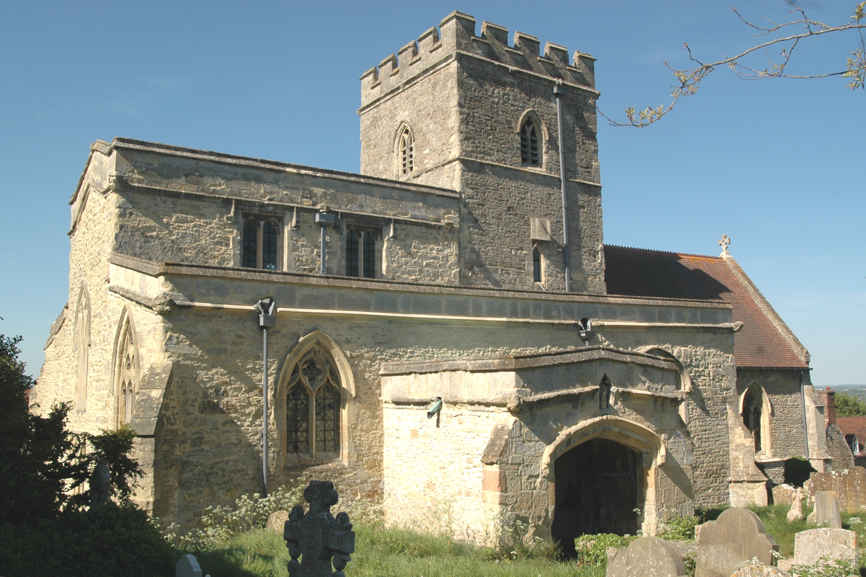
Beckley, Oxfordshire

Beckley is a village in the civil parish of Beckley and Stowood, in the South Oxfordshire district, in the county of Oxfordshire, England. It is about...

Oxford transmitting station

The Oxford transmitting station (sometimes known as the Beckley transmitter) is a broadcasting and telecommunications facility, situated on land 129.5...

Woodperry House

Woodperry House is a Grade I listed building in Stanton St John, South Oxfordshire, England. Woodperry was built from 1728 for John Morse, a London goldsmith...
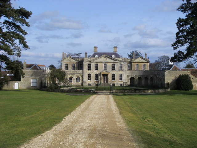
Beckley Park

Beckley Park is an English country house located near the village of Beckley, in Oxfordshire, England. It was built in 1540 by Lord Williams of Thame,...

Nearby Amenities

Located within 500m of 51.794237,-1.18319
Beckley
Is In: Oxfordshire, England, UK
Place: village
Wikidata: Q4878739
Lat/Long: 51.7970275/-1.1854397
Oxford transmitter
Alt Name: Beckley Transmitter
Communication Radio: yes
Communication Television: yes
Ele: 129
Height: 166
Man Made: mast
Tower Construction: guyed_lattice
Tower Type: communication
Lat/Long: 51.7906498/-1.1791025
Post Box
Collection Times: Mo-Fr 16:00; Sa 10:00
Post Box Type: lamp
Ref: OX3 550
Lat/Long: 51.7967042/-1.1835388
Booth: K6
Covered: booth
Disused Amenity: telephone
Man Made: telephone_box
Old Phone: +44 1865 351411
Lat/Long: 51.7967046/-1.1835079
Post Box
Collection Times: Mo-Fr 09:00; Sa 07:00
Post Box Type: lamp
Ref: OX3 356
Royal Cypher: EIIR
Royal Cypher Wikidata: Q33102113
Lat/Long: 51.7941515/-1.1766078
Bus Stop
Abingdon Arms PH
Bench: yes
Bin: yes
Bus: yes
Lit: no
Naptan AtcoCode: 340000084OPP
Naptan Bearing: W
Naptan CommonName: Abingdon Arms PH
Naptan Indicator: Opposite
Naptan Landmark: Abingdon Arms
Naptan NaptanCode: oxfawtjt
Naptan Notes: Timetable Case Only
Naptan Street: High Street
Naptan Verified: yes
Public Transport: platform
Route Ref: 108;118
Shelter: no
Source: naptan_import
Tactile Paving: no
Lat/Long: 51.7966895/-1.1820934
Bus Stop
Abingdon Arms PH
Bench: no
Bin: no
Bus: yes
Lit: no
Naptan AtcoCode: 340000084OUT
Naptan Bearing: E
Naptan BusStopType: CUS
Naptan CommonName: Abingdon Arms PH
Naptan Indicator: Outside
Naptan Landmark: Abingdon Arms
Naptan NaptanCode: oxfampwm
Naptan Street: High Street
Naptan Verified: no
Public Transport: platform
Shelter: no
Source: naptan_import
Tactile Paving: no
Lat/Long: 51.7967458/-1.1821268
Woodperry Road
Naptan AtcoCode: 340001746OUB
Naptan Bearing: NW
Naptan BusStopType: CUS
Naptan CommonName: Woodperry Road
Naptan Indicator: Outside Beckley Court
Naptan Landmark: Beckley Court
Naptan NaptanCode: oxfgdjdm
Naptan Street: Woodperry Road
Source: naptan_import
Lat/Long: 51.7939604/-1.1759855
Grit Bin
Lat/Long: 51.7956175/-1.1811111
Entrance: main
Lat/Long: 51.7978112/-1.1861392
Leisure: playground
Lat/Long: 51.79481/-1.1761445
Bench
Backrest: yes
Lat/Long: 51.7967043/-1.1820602
Board Type: notice
Information: board
Tourism: information
Lat/Long: 51.7967159/-1.1838922
Man Made: tower
Tower Construction: lattice
Tower Type: communication
Lat/Long: 51.7903271/-1.1804476
Evelyn Waugh
Erected By: Beckley & Area Community Benefit Society 2018
Inscription: Evelyn Waugh Author wrote, drank and lvoed here 1924-1931
Memorial: plaque
Note: blue plaque
Lat/Long: 51.7967894/-1.1820746
Board Type: notice
Information: board
Operator: Beckley & Area Community Benefit Society Ltd
Tourism: information
Lat/Long: 51.7967668/-1.1818787
Beckley Hill
Ele: 141
Natural: peak
Lat/Long: 51.7914539/-1.1860819
Direction: 190
Generator Method: photovoltaic
Generator Output Electricity: yes
Generator Solar Modules: 7
Generator Source: solar
Generator Type: solar_photovoltaic_panel
Location: roof
Power: generator
Lat/Long: 51.7947226/-1.178923
Direction: 100
Generator Method: photovoltaic
Generator Output Electricity: yes
Generator Solar Modules: 8
Generator Source: solar
Generator Type: solar_photovoltaic_panel
Location: roof
Power: generator
Lat/Long: 51.7946667/-1.1788772
Fixme: solar panels?
Lat/Long: 51.7949713/-1.1801497
Man Made: utility_pole
Lat/Long: 51.7918235/-1.1830696
Give Way
Direction: forward
Lat/Long: 51.796673/-1.1815465
Defibrillator
Emergency: defibrillator
Indoor: no
Lat/Long: 51.7943816/-1.1762529
The data included in this document is from www.openstreetmap.org. The data is made available under ODbL.

Have you been to Beckley and Stowood?

Leave your review of Beckley and Stowood below (or comments, questions and feedback).