Beckbury

Civil Parish in Shropshire

England

Beckbury

Farmland near Beckbury
Farmland near Beckbury Credit: Stephen Richards

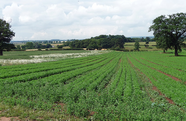
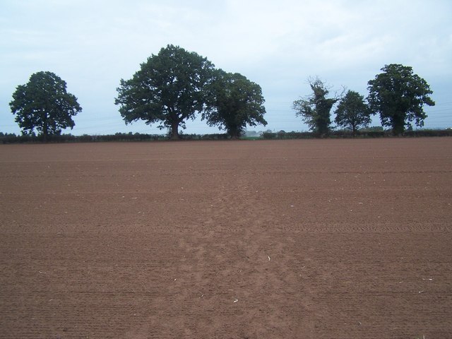
Beckbury is a small civil parish located in the county of Shropshire, England. Situated approximately 9 miles east of the town of Telford, it covers an area of around 8 square miles. The village itself is nestled in the picturesque Shropshire countryside and is surrounded by rolling hills and farmland.

With a population of around 1,000 residents, Beckbury is a close-knit community that offers a tranquil and peaceful environment for its inhabitants. The village features a range of traditional stone-built houses, some of which date back several centuries, giving it a charming and historic feel.

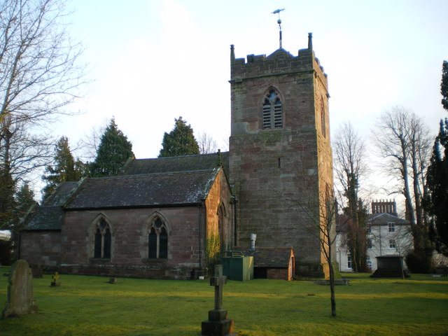
One of the notable landmarks in Beckbury is the St. Milburga's Church, a Grade II listed building that dates back to the 12th century. The church is renowned for its beautiful stained glass windows and its connection to the local history.

The village is well-served by amenities, including a popular pub, The Seven Stars, which is a hub for the community and offers a warm and friendly atmosphere. There is also a village hall that hosts various events and activities throughout the year.

For those who enjoy outdoor pursuits, Beckbury offers plenty of opportunities for walking and cycling, with numerous footpaths and bridleways crisscrossing the surrounding countryside. The nearby Shropshire Hills Area of Outstanding Natural Beauty provides stunning views and is a popular destination for hikers and nature enthusiasts.

In summary, Beckbury is a charming and idyllic village in Shropshire, offering a peaceful rural lifestyle and a strong sense of community.

If you have any feedback on the listing, please let us know in the comments section below.

Beckbury Images

Images are sourced within 2km of 52.612187/-2.341627 or Grid Reference SJ7601. Thanks to Geograph Open Source API. All images are credited.

Farmland near Beckbury
Footpath Near Badger
Footpath Towards Beckbury
Mill Cottages, Higford, 1935 Higford Mill and the cottages were owned around the 1870s & 1880s by the Overton family; the lady in this picture is Frances Flora Overton, who was born here in 1880, and pictured on a return visit in her 50s.
Mill Cottages, Higford, 1935
Higford Mill and the cottages were owned around the 1870s & 1880s by the Overton family; the lady in this picture is Frances Flora Overton, who was born here in 1880, and pictured on a return visit in her 50s.
The Mill House, Higford, 1935 Higford Mill and the adjacent cottages were owned around the 1870s & 1880s by the Overton family; the older lady in this picture is Frances Flora Overton, who was born here in 1880, and is pictured on a return visit in her 50s.
A more recent photo of the same building <a href="https://www.geograph.org.uk/photo/1781087">SJ7500 : Higford Mill</a>.
The Mill House, Higford, 1935
Higford Mill and the adjacent cottages were owned around the 1870s & 1880s by the Overton family; the older lady in this picture is Frances Flora Overton, who was born here in 1880, and is pictured on a return visit in her 50s. A more recent photo of the same building SJ7500 : Higford Mill.
4 & 5 Caynton Cottages near Ryton The much photographed Caynton Cottages, which are not nearly as old as they might appear. They are a pair of mid-19th century estate workers cottages, which are Grade II listed. An extract from the English Heritage listing text:- "Planted half timbering and pebbledash rendered infill on sandstone base, fishscale tiles separated by plain tiled bands to overhanging roof. 1½ storeys, gable fronted...". It also says that "Half timbering imitates local C17 style, square panels with concave lozenges and herringbone struts as decorative motifs".
4 & 5 Caynton Cottages near Ryton
The much photographed Caynton Cottages, which are not nearly as old as they might appear. They are a pair of mid-19th century estate workers cottages, which are Grade II listed. An extract from the English Heritage listing text:- "Planted half timbering and pebbledash rendered infill on sandstone base, fishscale tiles separated by plain tiled bands to overhanging roof. 1½ storeys, gable fronted...". It also says that "Half timbering imitates local C17 style, square panels with concave lozenges and herringbone struts as decorative motifs".
Beckbury Memorial Cross (war memorial), Badger Lane, Beckbury Located in the grounds of the Parish Church of St. Milburga, near the road. The inscription reads: "To the Glory of God and in memory of all who gave their lives in the Great War 1914-1919 especially those from this parish and in the Second World War 1939-1945". It is followed by the names of the nine from the parish who died. This is one of the memorials which gives the ending date for the First World War as 1919 rather than 1918.
Beckbury Memorial Cross (war memorial), Badger Lane, Beckbury
Located in the grounds of the Parish Church of St. Milburga, near the road. The inscription reads: "To the Glory of God and in memory of all who gave their lives in the Great War 1914-1919 especially those from this parish and in the Second World War 1939-1945". It is followed by the names of the nine from the parish who died. This is one of the memorials which gives the ending date for the First World War as 1919 rather than 1918.
St. Milburga's Church, Badger Lane, Beckbury The chancel dates from around 1300, further additions in the 18th century including the west tower, and then further work in Victorian times, and then the church underwent a restoration in 1884. The building is of red sandstone.

<a href="https://www.geograph.org.uk/photo/2761209">SJ7601 : St. Milburga's Church - porch, Badger Lane, Beckbury</a>.
St. Milburga's Church, Badger Lane, Beckbury
The chancel dates from around 1300, further additions in the 18th century including the west tower, and then further work in Victorian times, and then the church underwent a restoration in 1884. The building is of red sandstone. SJ7601 : St. Milburga's Church - porch, Badger Lane, Beckbury.
St. Milburga's Church - porch, Badger Lane, Beckbury The porch dates from 1888 and was designed by T.H. Fleming, who was also responsible for the restoration of the church in 1884.

<a href="https://www.geograph.org.uk/photo/2761186">SJ7601 : St. Milburga's Church, Badger Lane, Beckbury</a>.
St. Milburga's Church - porch, Badger Lane, Beckbury
The porch dates from 1888 and was designed by T.H. Fleming, who was also responsible for the restoration of the church in 1884. SJ7601 : St. Milburga's Church, Badger Lane, Beckbury.
Seven Stars (1), Madeley Road, Beckbury A large and popular pub which has been running since at least 1846, possibly earlier, although much enlarged and altered over the years. It is the village's only pub, although in Victorian times, at least, and earlier there were a number of beerhouses.

<a href="https://www.geograph.org.uk/photo/2762266">SJ7601 : Seven Stars (2), Madeley Road, Beckbury</a>.
<a href="https://www.geograph.org.uk/photo/2762291">SJ7601 : Seven Stars (3) - sign, Madeley Road, Beckbury</a>.
<a href="https://www.geograph.org.uk/photo/2762311">SJ7601 : Seven Stars (4) - rear view, Madeley Road, Beckbury</a>.
Seven Stars (1), Madeley Road, Beckbury
A large and popular pub which has been running since at least 1846, possibly earlier, although much enlarged and altered over the years. It is the village's only pub, although in Victorian times, at least, and earlier there were a number of beerhouses. SJ7601 : Seven Stars (2), Madeley Road, Beckbury. SJ7601 : Seven Stars (3) - sign, Madeley Road, Beckbury. SJ7601 : Seven Stars (4) - rear view, Madeley Road, Beckbury.
Seven Stars (2), Madeley Road, Beckbury A trade directory of the early 1870's refers to the pub as the Seven Stars Inn.

Other photos:- <a href="https://www.geograph.org.uk/photo/2762250">SJ7601 : Seven Stars (1), Madeley Road, Beckbury</a>.
Seven Stars (2), Madeley Road, Beckbury
A trade directory of the early 1870's refers to the pub as the Seven Stars Inn. Other photos:- SJ7601 : Seven Stars (1), Madeley Road, Beckbury.
Seven Stars (3) - sign, Madeley Road, Beckbury Interestingly the sign shows both a plough and the seven stars in the sky which form the constellation of Ursa Major, which is often known as The Plough. The latter is a frequent sign for pubs, particularly in rural areas where agriculture is or used to be the major occupation. Pubs called Seven Stars are far less common, but there are still a few around. At the bottom of the sign are the words eating, drinking, relaxing.

Other photos:- <a href="https://www.geograph.org.uk/photo/2762250">SJ7601 : Seven Stars (1), Madeley Road, Beckbury</a>.
Seven Stars (3) - sign, Madeley Road, Beckbury
Interestingly the sign shows both a plough and the seven stars in the sky which form the constellation of Ursa Major, which is often known as The Plough. The latter is a frequent sign for pubs, particularly in rural areas where agriculture is or used to be the major occupation. Pubs called Seven Stars are far less common, but there are still a few around. At the bottom of the sign are the words eating, drinking, relaxing. Other photos:- SJ7601 : Seven Stars (1), Madeley Road, Beckbury.
Seven Stars (4) - rear view, Madeley Road, Beckbury A view from the pub's car park.

Other photos:- <a href="https://www.geograph.org.uk/photo/2762250">SJ7601 : Seven Stars (1), Madeley Road, Beckbury</a>.
Seven Stars (4) - rear view, Madeley Road, Beckbury
A view from the pub's car park. Other photos:- SJ7601 : Seven Stars (1), Madeley Road, Beckbury.
Higford Lane, Beckbury This short lane continues as a track, over which a public bridleway runs. The brown wooden post is a bridleway marker.
Higford Lane, Beckbury
This short lane continues as a track, over which a public bridleway runs. The brown wooden post is a bridleway marker.
Badger Lane, Beckbury The banner on the right is advertising the Beckbury Show.
Badger Lane, Beckbury
The banner on the right is advertising the Beckbury Show.
Bridleway near Higford through woodland On the route of Monarch’s Way long distance footpath
Bridleway near Higford through woodland
On the route of Monarch’s Way long distance footpath
Show me another place!

Beckbury is located at Grid Ref: SJ7601 (Lat: 52.612187, Lng: -2.341627)

Unitary Authority: Shropshire

Police Authority: West Mercia

What 3 Words

///dispenser.organic.discouraged. Near Ryton, Shropshire

Nearby Locations

Beckbury Beckbury

Related Wikis

Beckbury

Beckbury is a village and civil parish in Shropshire, England. Beckbury had a population of 327 according to the 2001 census, increasing to 340 at the...

Ryton, Shropshire

Ryton is a village and civil parish in Shropshire, England, in the district of Bridgnorth. It lies about one mile north north west of Beckbury. The civil...

Caynton Caves

The Caynton Caves are a series of man-made underground chambers in the grounds of Caynton Hall, near Beckbury, Shropshire, England. Their original purpose...

Burnhill Green

Burnhill Green is a small hamlet near Pattingham, situated in Staffordshire, England, in the former parish of Patshull. The hamlet is on the edge of the...

Nearby Amenities

Located within 500m of 52.612187,-2.341627
War Memorial
Historic: memorial
Source: survey
Lat/Long: 52.6114987/-2.3483412
Grit Bin
Lat/Long: 52.6111737/-2.3466253
Bench
Source: survey
Lat/Long: 52.6115676/-2.3486497
FIXME: continues
Lat/Long: 52.6122612/-2.3445021
Post Box
Post Box Type: pillar
Source: visual survey;estimate
Lat/Long: 52.6121515/-2.3484626
Generator Method: photovoltaic
Generator Output Electricity: yes
Generator Source: solar
Generator Type: solar_photovoltaic_panel
Location: roof
Power: generator
Lat/Long: 52.6131844/-2.3474278
Generator Method: photovoltaic
Generator Output Electricity: yes
Generator Source: solar
Generator Type: solar_photovoltaic_panel
Location: roof
Power: generator
Lat/Long: 52.6130582/-2.3483826
Generator Method: photovoltaic
Generator Output Electricity: yes
Generator Source: solar
Generator Type: solar_photovoltaic_panel
Location: roof
Power: generator
Lat/Long: 52.6130533/-2.3483169
Booth: K6
Colour: blue
Disused Amenity: telephone
Man Made: telephone_box
Lat/Long: 52.6131016/-2.3480882
The data included in this document is from www.openstreetmap.org. The data is made available under ODbL.

Have you been to Beckbury?

Leave your review of Beckbury below (or comments, questions and feedback).