Baddiley

Civil Parish in Cheshire

England

Baddiley

Maize Forage maize grown for winter fodder or biomass electricity generation via anaerobic digesters.
Maize Credit: Richard Webb

Baddiley is a civil parish located in the county of Cheshire, England. It is situated in the South Cheshire district, approximately 4 miles to the northeast of Nantwich. The parish covers an area of around 1,000 acres and has a relatively small population of approximately 200 people.

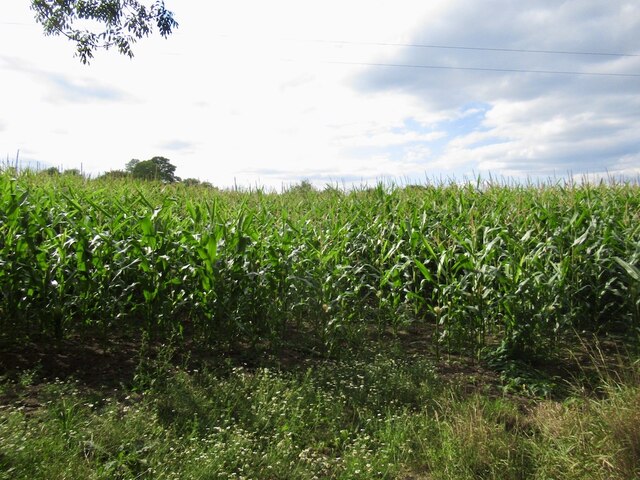
The village of Baddiley is characterized by its rural charm and picturesque surroundings. It is surrounded by beautiful countryside, with rolling hills, fields, and meadows that provide a peaceful and tranquil atmosphere. The parish is known for its agricultural land, and farming plays a significant role in the local economy.

Baddiley is home to a few notable landmarks and historical sites. One of the most prominent features is St. Michael and All Angels Church, a Grade II listed building that dates back to the 14th century. The church is known for its stunning architecture and intricate stained glass windows.

The village also has a primary school, providing education for the local children, and a village hall that serves as a community hub. Residents and visitors can enjoy various outdoor activities and explore the surrounding countryside through walking or cycling routes in the area.

Although Baddiley is a small parish, it offers a close-knit community and a peaceful environment for its residents. It is well-connected to neighboring towns and cities, with good transport links and easy access to amenities and services.

If you have any feedback on the listing, please let us know in the comments section below.

Baddiley Images

Images are sourced within 2km of 53.052533/-2.592217 or Grid Reference SJ6050. Thanks to Geograph Open Source API. All images are credited.

Maize Forage maize grown for winter fodder or biomass electricity generation via anaerobic digesters.
Maize
Forage maize grown for winter fodder or biomass electricity generation via anaerobic digesters.
Hey Lane
Hey Lane
A small field, Larden Green
View below Baddiley No. 2 Lock, Llangollen Canal The overflow channel re-enters the canal immediately below the lock.
View below Baddiley No. 2 Lock, Llangollen Canal
The overflow channel re-enters the canal immediately below the lock.
View north from Baddiley Bridge, Llangollen Canal
Done with fishing - for today anyway!
Rest time for some
Rest time for some
Baddiley Lock No 1 near Wrenbury Heath, Cheshire There are three locks in the short Baddiley flight on the Llangollen Canal. Top Lock (No 1) allows a fall of 6ft 9in (about two metres) in the water level. Baddiley Bridge (No 14) is beyond the moored narrowboat to the north.
Baddiley Lock No 1 near Wrenbury Heath, Cheshire
There are three locks in the short Baddiley flight on the Llangollen Canal. Top Lock (No 1) allows a fall of 6ft 9in (about two metres) in the water level. Baddiley Bridge (No 14) is beyond the moored narrowboat to the north.
Baddiley Bottom Lock near Ravensmoor, Cheshire Travelling north the short flight of three Baddiley Locks lowers the water level by 19ft 8in (about 5 metres). Here, No 3 lock provides a fall of 6ft 1in (1·85 metres).

The Llangollen Branch of the Shropshire Union Canal starts by the River Dee at Llantysilio and leads to the main line at Hurleston Junction, a distance of 46 miles, with twenty-one locks. Water is supplied from the River Dee to the canal, and on to Hurleston Reservoir, a source of domestic water supplies. This results in a noticeable flow of water from west to east; unusual in a canal.

The Llangollen Canal was started in 1795, but not completed for many years. It was eventually absorbed by the Shropshire Union Company in 1846.
Baddiley Bottom Lock near Ravensmoor, Cheshire
Travelling north the short flight of three Baddiley Locks lowers the water level by 19ft 8in (about 5 metres). Here, No 3 lock provides a fall of 6ft 1in (1·85 metres). The Llangollen Branch of the Shropshire Union Canal starts by the River Dee at Llantysilio and leads to the main line at Hurleston Junction, a distance of 46 miles, with twenty-one locks. Water is supplied from the River Dee to the canal, and on to Hurleston Reservoir, a source of domestic water supplies. This results in a noticeable flow of water from west to east; unusual in a canal. The Llangollen Canal was started in 1795, but not completed for many years. It was eventually absorbed by the Shropshire Union Company in 1846.
Baddiley Middle Lock near Ravensmoor, Cheshire Travelling north the short flight of three Baddiley Locks lowers the water level by 19ft 8in (about 5 metres). Here, No 2 lock provides a fall of 6ft 10in (2·1 metres).

The Llangollen Branch of the Shropshire Union Canal starts by the River Dee at Llantysilio and leads to the main line at Hurleston Junction, a distance of 46 miles, with twenty-one locks. Water is supplied from the River Dee to the canal, and on to Hurleston Reservoir, a source of domestic water supplies. This results in a noticeable flow of water from west to east; unusual in a canal.

The Llangollen Canal was started in 1795, but not completed for many years. It was eventually absorbed by the Shropshire Union Company in 1846.
Baddiley Middle Lock near Ravensmoor, Cheshire
Travelling north the short flight of three Baddiley Locks lowers the water level by 19ft 8in (about 5 metres). Here, No 2 lock provides a fall of 6ft 10in (2·1 metres). The Llangollen Branch of the Shropshire Union Canal starts by the River Dee at Llantysilio and leads to the main line at Hurleston Junction, a distance of 46 miles, with twenty-one locks. Water is supplied from the River Dee to the canal, and on to Hurleston Reservoir, a source of domestic water supplies. This results in a noticeable flow of water from west to east; unusual in a canal. The Llangollen Canal was started in 1795, but not completed for many years. It was eventually absorbed by the Shropshire Union Company in 1846.
Baddiley Bottom Lock near Ravensmoor, Cheshire Travelling north the short flight of three Baddiley Locks lowers the water level by 19ft 8in (about 5 metres). Here, No 3 lock provides a fall of 6ft 1in (1·85 metres).

The Llangollen Branch of the Shropshire Union Canal starts by the River Dee at Llantysilio and leads to the main line at Hurleston Junction, a distance of 46 miles, with twenty-one locks. Water is supplied from the River Dee to the canal, and on to Hurleston Reservoir, a source of domestic water supplies. This results in a noticeable flow of water from west to east; unusual in a canal.

The Llangollen Canal was started in 1795, but not completed for many years. It was eventually absorbed by the Shropshire Union Company in 1846.
Baddiley Bottom Lock near Ravensmoor, Cheshire
Travelling north the short flight of three Baddiley Locks lowers the water level by 19ft 8in (about 5 metres). Here, No 3 lock provides a fall of 6ft 1in (1·85 metres). The Llangollen Branch of the Shropshire Union Canal starts by the River Dee at Llantysilio and leads to the main line at Hurleston Junction, a distance of 46 miles, with twenty-one locks. Water is supplied from the River Dee to the canal, and on to Hurleston Reservoir, a source of domestic water supplies. This results in a noticeable flow of water from west to east; unusual in a canal. The Llangollen Canal was started in 1795, but not completed for many years. It was eventually absorbed by the Shropshire Union Company in 1846.
Canal lock overflow channel near Ravensmoor, Cheshire At Baddiley Middle Lock.
The overflow channels by locks on the Llangollen Canal need a greater capacity than most canals because of the considerable amount of water flowing down from its source, the River Dee at Llantysilio. Not only does the river provide water for the canal, but also to the enlarged (1959) Hurleston Reservoir, which feeds the Shropshire Union Canal main line as well as domestic water requirements. This arrangement means there is a current flowing in this canal, very noticeable in some sections approaching Llangollen. Narrowboat tillermen approaching a lock from below can have real problems when crossing the sometimes fierce broadside overflow surges as they cascade back into the canal. Good gongoozler fodder!

<a href="https://www.geograph.org.uk/photo/3214609">SJ6152 : Canal lock overflow near Ravensmoor, Cheshire</a>
Canal lock overflow channel near Ravensmoor, Cheshire
At Baddiley Middle Lock. The overflow channels by locks on the Llangollen Canal need a greater capacity than most canals because of the considerable amount of water flowing down from its source, the River Dee at Llantysilio. Not only does the river provide water for the canal, but also to the enlarged (1959) Hurleston Reservoir, which feeds the Shropshire Union Canal main line as well as domestic water requirements. This arrangement means there is a current flowing in this canal, very noticeable in some sections approaching Llangollen. Narrowboat tillermen approaching a lock from below can have real problems when crossing the sometimes fierce broadside overflow surges as they cascade back into the canal. Good gongoozler fodder! SJ6152 : Canal lock overflow near Ravensmoor, Cheshire
Baddiley Middle Lock near Ravensmoor, Cheshire Travelling north the short flight of three Baddiley Locks lowers the water level by 19ft 8in (about 5 metres). Here, No 2 lock provides a fall of 6ft 10in (2·1 metres). Note the wide overflow channel on the left. <a title="https://www.geograph.org.uk/photo/3207741" href="https://www.geograph.org.uk/photo/3207741">Link</a>

The Llangollen Branch of the Shropshire Union Canal starts by the River Dee at Llantysilio and leads to the main line at Hurleston Junction, a distance of 46 miles, with twenty-one locks. Water is supplied from the River Dee to the canal, and on to Hurleston Reservoir, a source of domestic water supplies. This results in a noticeable flow of water from west to east; unusual in a canal.

The Llangollen Canal was started in 1795, but not completed for many years. It was eventually absorbed by the Shropshire Union Company in 1846.
Baddiley Middle Lock near Ravensmoor, Cheshire
Travelling north the short flight of three Baddiley Locks lowers the water level by 19ft 8in (about 5 metres). Here, No 2 lock provides a fall of 6ft 10in (2·1 metres). Note the wide overflow channel on the left. Link The Llangollen Branch of the Shropshire Union Canal starts by the River Dee at Llantysilio and leads to the main line at Hurleston Junction, a distance of 46 miles, with twenty-one locks. Water is supplied from the River Dee to the canal, and on to Hurleston Reservoir, a source of domestic water supplies. This results in a noticeable flow of water from west to east; unusual in a canal. The Llangollen Canal was started in 1795, but not completed for many years. It was eventually absorbed by the Shropshire Union Company in 1846.
Baddiley Middle Lock near Ravensmoor, Cheshire Travelling north the short flight of three Baddiley Locks lowers the water level by 19ft 8in (about 5 metres). Here, No 2 lock provides a fall of 6ft 10in (2·1 metres).

The Llangollen Branch of the Shropshire Union Canal starts by the River Dee at Llantysilio and leads to the main line at Hurleston Junction, a distance of 46 miles, with twenty-one locks. Water is supplied from the River Dee to the canal, and on to Hurleston Reservoir, a source of domestic water supplies. This results in a noticeable flow of water from west to east; unusual in a canal.

The Llangollen Canal was started in 1795, but not completed for many years. It was eventually absorbed by the Shropshire Union Company in 1846.
Baddiley Middle Lock near Ravensmoor, Cheshire
Travelling north the short flight of three Baddiley Locks lowers the water level by 19ft 8in (about 5 metres). Here, No 2 lock provides a fall of 6ft 10in (2·1 metres). The Llangollen Branch of the Shropshire Union Canal starts by the River Dee at Llantysilio and leads to the main line at Hurleston Junction, a distance of 46 miles, with twenty-one locks. Water is supplied from the River Dee to the canal, and on to Hurleston Reservoir, a source of domestic water supplies. This results in a noticeable flow of water from west to east; unusual in a canal. The Llangollen Canal was started in 1795, but not completed for many years. It was eventually absorbed by the Shropshire Union Company in 1846.
Llangollen Canal near Wrenbury Heath, Cheshire This is the view as you approach Baddiley Middle Lock.

The Llangollen Canal was started in 1795, but not completed for many years. It was eventually absorbed by the Shropshire Union Company in 1846.
Llangollen Canal near Wrenbury Heath, Cheshire
This is the view as you approach Baddiley Middle Lock. The Llangollen Canal was started in 1795, but not completed for many years. It was eventually absorbed by the Shropshire Union Company in 1846.
Llangollen Canal south from Baddiley No1 Lock The Llangollen canal is an arm of the Shropshire Union canal that runs from Hurleston Junction to Llangollen with a wide variety of scenery along its course. Its total length is 46 miles, but the last 1½ miles from Llangollen to Llantisilio is unnavigable by any boats over about 10' length.
The canal's vital statistics for craft are:
Length 72 '
Beam 6'10"
Headroom 7'
Draught 2'3" (Hurleston to Pontcysyllte) 2' (P. to Llangollen)
These are the maximum dimensions for any craft, based on the minimum dimensions of locks & bridges.
There are a total of 21 locks on the canal, but only two between Llangollen and Whitchurch (a distance of about 31 miles). One of the most notable things about the canal is the strong flow especially in the "narrows" near Llangollen and in the tunnels near Chirk. About 12 million gallons of water passes down this canal from the River Dee to the Shropshire Union every day.
The most famous feature of this canal is the superb feat of engineering that is the 200-year-old Pontcysyllte Aqueduct rising 126' above the River Dee and running for over 335 yds - for more information on this see the numerous photos for squares SJ2742 and SJ2741
Llangollen Canal south from Baddiley No1 Lock
The Llangollen canal is an arm of the Shropshire Union canal that runs from Hurleston Junction to Llangollen with a wide variety of scenery along its course. Its total length is 46 miles, but the last 1½ miles from Llangollen to Llantisilio is unnavigable by any boats over about 10' length. The canal's vital statistics for craft are: Length 72 ' Beam 6'10" Headroom 7' Draught 2'3" (Hurleston to Pontcysyllte) 2' (P. to Llangollen) These are the maximum dimensions for any craft, based on the minimum dimensions of locks & bridges. There are a total of 21 locks on the canal, but only two between Llangollen and Whitchurch (a distance of about 31 miles). One of the most notable things about the canal is the strong flow especially in the "narrows" near Llangollen and in the tunnels near Chirk. About 12 million gallons of water passes down this canal from the River Dee to the Shropshire Union every day. The most famous feature of this canal is the superb feat of engineering that is the 200-year-old Pontcysyllte Aqueduct rising 126' above the River Dee and running for over 335 yds - for more information on this see the numerous photos for squares SJ2742 and SJ2741
Show me another place!

Baddiley is located at Grid Ref: SJ6050 (Lat: 53.052533, Lng: -2.592217)

Unitary Authority: Cheshire East

Police Authority: Cheshire

What 3 Words

///montage.woof.guideline. Near Nantwich, Cheshire

Nearby Locations

Baddiley

Related Wikis

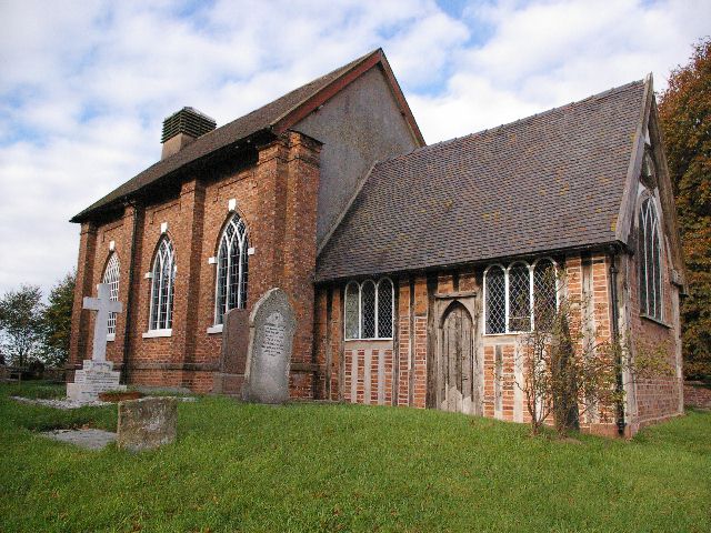
St Michael's Church, Baddiley

St Michael's Church is in the civil parish of Baddiley, Cheshire, England. It is recorded in the National Heritage List for England as a designated Grade...
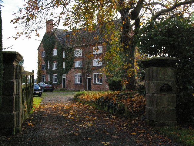
Baddiley Hall

Baddiley Hall is a country house in the settlement of Baddiley in Cheshire, England. Previously there was a half-timbered house on the site, but this...

Ravensmoor

Ravensmoor is a village in the unitary authority of Cheshire East and the ceremonial county of Cheshire, England, located at SJ620505. It is split between...

Swanley, Cheshire

Swanley is a hamlet at SJ618523 in the unitary authority of Cheshire East and the ceremonial county of Cheshire, England. It mainly falls within the civil...

Nearby Amenities

Located within 500m of 53.052533,-2.592217
Barrier: stile
Foot: yes
Lat/Long: 53.0555283/-2.5908408
Baddiley Hall Farm
Place: farm
Lat/Long: 53.0502444/-2.5898445
Baddiley Lodge
Place: locality
Lat/Long: 53.0534466/-2.5918561
Dairy House Farm
Place: farm
Lat/Long: 53.0524706/-2.5961276
Power: pole
Lat/Long: 53.0565966/-2.593047
Power: pole
Lat/Long: 53.0559405/-2.5944847
Power: pole
Lat/Long: 53.0553214/-2.5958982
Power: pole
Lat/Long: 53.0546927/-2.5973332
Power: pole
Lat/Long: 53.053985/-2.5988916
The data included in this document is from www.openstreetmap.org. The data is made available under ODbL.

Have you been to Baddiley?

Leave your review of Baddiley below (or comments, questions and feedback).