Brightwell Baldwin

Settlement in Oxfordshire South Oxfordshire

England

Brightwell Baldwin

Direction Sign – Signpost on the B480 in Cuxham with Easington parish Located on a grass triangle in the centre of a junction on the B480 at Cuttmill Cottages in Cuxham with Easington parish. 3 arms and annulus finial.

Milestone Society National ID: OX_SU6596
Direction Sign – Signpost on the B480 in Cuxham with Easington parish Credit: John V Nicholls

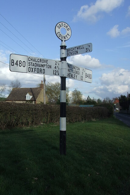
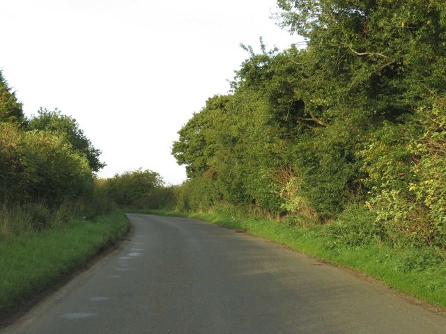
Brightwell Baldwin is a small village located in the county of Oxfordshire, England. Situated approximately four miles southeast of the market town of Watlington, it is nestled in the Chiltern Hills, an Area of Outstanding Natural Beauty. The village is surrounded by picturesque countryside, offering stunning views and an idyllic setting.

The origins of Brightwell Baldwin can be traced back to medieval times, with the first records of the village dating back to the 12th century. It is characterized by a charming mix of traditional thatched cottages, historic buildings, and a quaint village church dedicated to St. Bartholomew.

Despite its small size, Brightwell Baldwin boasts a strong sense of community, with various social activities and events organized throughout the year. The village pub, The Lord Nelson, serves as a hub for residents and visitors alike to gather and enjoy a drink or a meal.

Nature enthusiasts will find plenty to explore in the surrounding area. The village is located near several walking trails and footpaths, including the Ridgeway National Trail, providing opportunities for outdoor activities and enjoying the beautiful countryside.

While Brightwell Baldwin offers a peaceful and rural lifestyle, it is conveniently located within reach of larger towns and cities. The nearby market town of Watlington provides essential amenities and services, while the city of Oxford is approximately 18 miles away, offering a wider range of cultural, educational, and recreational opportunities.

In summary, Brightwell Baldwin is a charming and picturesque village in the heart of Oxfordshire, offering a tranquil setting, a strong community spirit, and easy access to both countryside and urban amenities.

If you have any feedback on the listing, please let us know in the comments section below.

Brightwell Baldwin Images

Images are sourced within 2km of 51.650381/-1.054865 or Grid Reference SU6595. Thanks to Geograph Open Source API. All images are credited.

Direction Sign – Signpost on the B480 in Cuxham with Easington parish Located on a grass triangle in the centre of a junction on the B480 at Cuttmill Cottages in Cuxham with Easington parish. 3 arms and annulus finial.

Milestone Society National ID: OX_SU6596
Direction Sign – Signpost on the B480 in Cuxham with Easington parish
Located on a grass triangle in the centre of a junction on the B480 at Cuttmill Cottages in Cuxham with Easington parish. 3 arms and annulus finial. Milestone Society National ID: OX_SU6596
Direction Sign – Signpost on the B480 in Cuxham Located in Cuxham on the northeast side of a T junction on the B480, Cuxham with Easington parish. 3 arms and annulus finial. 

Milestone Society National ID: OX_SU6695
Direction Sign – Signpost on the B480 in Cuxham
Located in Cuxham on the northeast side of a T junction on the B480, Cuxham with Easington parish. 3 arms and annulus finial. Milestone Society National ID: OX_SU6695
Farmland, Cuxham A footpath to the south-west of the village follows the edge of a field of maize.
Farmland, Cuxham
A footpath to the south-west of the village follows the edge of a field of maize.
Farmland, Brightwell Baldwin Fields of wheat beside the bridleway heading west towards Berrick Salome.
Farmland, Brightwell Baldwin
Fields of wheat beside the bridleway heading west towards Berrick Salome.
Farmland, Chalgrove The footpath north of Cadwell Covert heads towards another copse.
Farmland, Chalgrove
The footpath north of Cadwell Covert heads towards another copse.
New houses, Chalgrove Houses on Lacey Green, part of the recent Chalgrove Meadow development, look out onto an area mostly left to  nature with ponds and a play area.
New houses, Chalgrove
Houses on Lacey Green, part of the recent Chalgrove Meadow development, look out onto an area mostly left to nature with ponds and a play area.
House and phone box in Cuxham This was making use of the lowest possible amount of available light.
House and phone box in Cuxham
This was making use of the lowest possible amount of available light.
Isolated house on the B480 near Cuxham
Rural road to Cuxham
Road into Brightwell Upperton
Rural road to Cuxham
The road to Cuxham passes Lodge House
The road through Brightwell Baldwin
Rural road to Cuxham
The Half Moon, Cuxham
Show me another place!

Brightwell Baldwin is located at Grid Ref: SU6595 (Lat: 51.650381, Lng: -1.054865)

Administrative County: Oxfordshire

District: South Oxfordshire

Police Authority: Thames Valley

What 3 Words

///misfits.excellent.access. Near Chalgrove, Oxfordshire

Related Wikis

Brightwell Baldwin

Brightwell Baldwin is a village and civil parish in Oxfordshire, about 4+1⁄2 miles (7 km) northeast of Wallingford. It was historically in the Hundred...

Henley (UK Parliament constituency)

Henley is a constituency in Oxfordshire represented in the House of Commons of the UK Parliament since 2008 by John Howell, a Member of Parliament from...

South Oxfordshire

South Oxfordshire is a local government district in the ceremonial county of Oxfordshire, England. Its council is temporarily based outside the district...

Cuxham

Cuxham is a village and former civil parish, now in the parish of Cuxham with Easington, in the South Oxfordshire district, in the county of Oxfordshire...

Cuxham with Easington

Cuxham with Easington is a civil parish in South Oxfordshire. It includes the villages of Cuxham and Easington. The 2011 Census recorded a parish population...

Britwell Salome

Britwell Salome is a village and civil parish in South Oxfordshire, England centred 4+1⁄2 miles (7 km) northeast of Wallingford. The 2011 Census recorded...

Easington, South Oxfordshire

Easington is a small village in the civil parish of Cuxham with Easington, in the South Oxfordshire district, in the county of Oxfordshire, England. It...

Chalgrove

Chalgrove is a village and civil parish in South Oxfordshire about 10 miles (16 km) southeast of Oxford. The parish includes the hamlet of Rofford and...

Nearby Amenities

Located within 500m of 51.650381,-1.054865
Pub
Lord Nelson
Fhrs Id: 272137
Wikidata: Q26476977
Lat/Long: 51.6498002/-1.0567173
Bus Stop
Lord Nelson Inn
Bus: yes
Naptan AtcoCode: 340000134CH
Naptan Bearing: SW
Naptan BusStopType: CUS
Naptan CommonName: Lord Nelson Inn
Naptan Indicator: Outside
Naptan Landmark: Church
Naptan NaptanCode: oxfamjwp
Naptan Street: Unclassified Road
Naptan Verified: no
Public Transport: platform
Source: naptan_import
Lat/Long: 51.6498275/-1.0567654
Bus Stop
Lord Nelson Inn
Bus: yes
Naptan AtcoCode: 340000134OCH
Naptan Bearing: NE
Naptan BusStopType: CUS
Naptan CommonName: Lord Nelson Inn
Naptan Indicator: Opposite
Naptan Landmark: Church
Naptan NaptanCode: oxfamjwm
Naptan Street: Unclassified Road
Naptan Verified: no
Public Transport: platform
Source: naptan_import
Lat/Long: 51.6498733/-1.0568801
Barrier: stile
Foot: yes
Lat/Long: 51.6518784/-1.0571337
Barrier: stile
Foot: yes
Lat/Long: 51.6505034/-1.0550476
Post Box
Post Box Mounting: wooden_post
Post Box Type: lamp
Ref: OX49 518
Royal Cypher: EIIR
Royal Cypher Wikidata: Q33102113
Lat/Long: 51.6503704/-1.055309
Power: pole
Source: Bing
Lat/Long: 51.6510508/-1.0612348
Power: pole
Source: Bing
Lat/Long: 51.6502786/-1.0603307
Barrier: stile
Bicycle: no
Foot: yes
Material: wood
Stile: stepover
Lat/Long: 51.6511365/-1.052972
Barrier: stile
Bicycle: no
Foot: yes
Material: wood
Stile: stepover
Lat/Long: 51.6513517/-1.052605
Telephone
Booth: K6
Covered: booth
Listed Status: Grade II
Operator: BT
Operator Wikidata: Q593786
Phone: +44 1491 612213
Lat/Long: 51.6502656/-1.0557918
The data included in this document is from www.openstreetmap.org. The data is made available under ODbL.

Have you been to Brightwell Baldwin?

Leave your review of Brightwell Baldwin below (or comments, questions and feedback).