Asterby

Civil Parish in Lincolnshire East Lindsey

England

Asterby

Spring course, Red Hill Farm, Goulceby: aerial 2022
Spring course, Red Hill Farm, Goulceby: aerial 2022 Credit: Simon Tomson

Asterby is a civil parish located in the East Lindsey district of Lincolnshire, England. Situated approximately 6 miles northeast of Horncastle, the village is nestled amidst the picturesque Lincolnshire Wolds, an Area of Outstanding Natural Beauty.

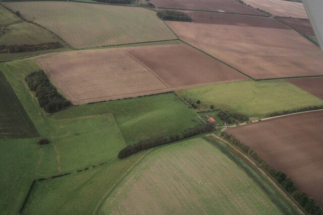
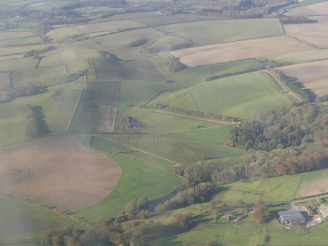
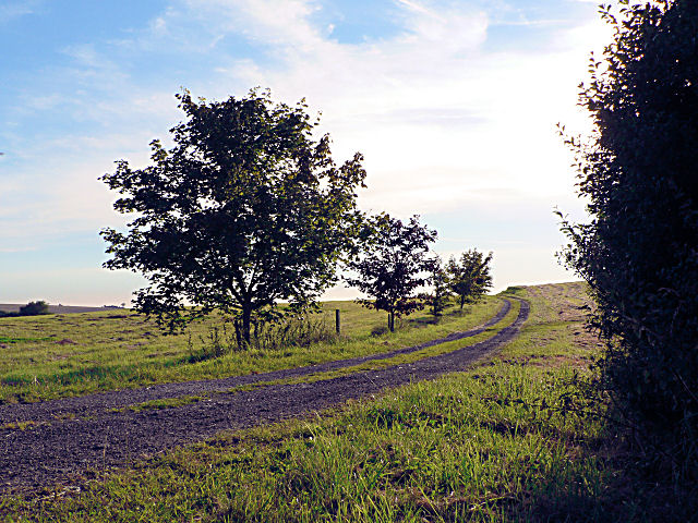
With a population of around 100 residents, Asterby is a small and tight-knit community. The village is predominantly rural, characterized by charming cottages, open fields, and rolling hills. The surrounding countryside offers breathtaking views, making it a popular destination for walkers, cyclists, and nature enthusiasts.

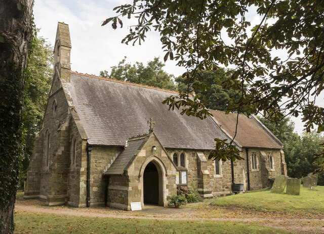
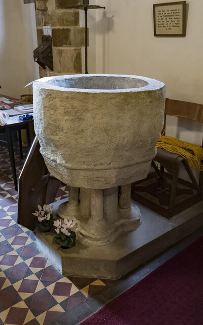
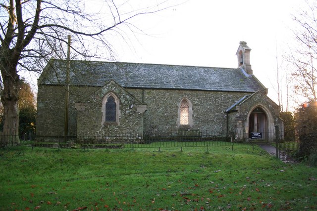
Asterby's history dates back to medieval times, with evidence of settlements and agricultural activity. Today, the village retains its rural charm, with a mix of traditional and modern homes. The prominent St Peter's Church, constructed in the 13th century and restored in the 19th century, stands as a testament to Asterby's historical significance.

Although Asterby does not have any shops or amenities, it benefits from its proximity to nearby towns and villages such as Horncastle, which offers a range of services and facilities. The village's peaceful environment is a major draw for those seeking a tranquil lifestyle away from the hustle and bustle of larger urban areas.

Asterby's community spirit is evident through its active village hall, which hosts various social events and gatherings throughout the year. Residents also enjoy participating in local sports clubs and societies, fostering a strong sense of community cohesion.

In summary, Asterby is a charming rural village in Lincolnshire, offering a tranquil lifestyle amidst the beautiful Lincolnshire Wolds. With its rich history and picturesque setting, it is a place that captures the hearts of both residents and visitors alike.

If you have any feedback on the listing, please let us know in the comments section below.
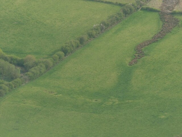
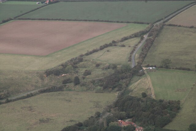
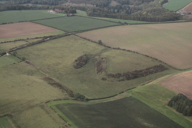
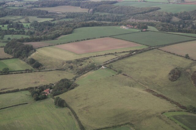
Asterby Images

Images are sourced within 2km of 53.291536/-0.105604 or Grid Reference TF2678. Thanks to Geograph Open Source API. All images are credited.

Spring course, Red Hill Farm, Goulceby: aerial 2022
Benchmark on Building at Manor Farm This indistinct benchmark is at the southeast end of a long roadside farm building.  See <a title="https://www.geograph.org.uk/photo/7395110" href="https://www.geograph.org.uk/photo/7395110">Link</a> for a wider view and <span class="nowrap"><a title="https://www.bench-marks.org.uk/bm182892" rel="nofollow ugc noopener" href="https://www.bench-marks.org.uk/bm182892">Link</a><img style="margin-left:2px;" alt="External link" title="External link - shift click to open in new window" src="https://s1.geograph.org.uk/img/external.png" width="10" height="10"/></span> for details of the mark.
Benchmark on Building at Manor Farm
This indistinct benchmark is at the southeast end of a long roadside farm building. See Link for a wider view and LinkExternal link for details of the mark.
Farm Building at Manor Farm There is an indistinct benchmark at the near end of this long roadside farm building.  See <a title="https://www.geograph.org.uk/photo/7395107" href="https://www.geograph.org.uk/photo/7395107">Link</a> for a closer view and <span class="nowrap"><a title="https://www.bench-marks.org.uk/bm182892" rel="nofollow ugc noopener" href="https://www.bench-marks.org.uk/bm182892">Link</a><img style="margin-left:2px;" alt="External link" title="External link - shift click to open in new window" src="https://s1.geograph.org.uk/img/external.png" width="10" height="10"/></span> for details of the mark.
Farm Building at Manor Farm
There is an indistinct benchmark at the near end of this long roadside farm building. See Link for a closer view and LinkExternal link for details of the mark.
Redhill, near Stenigot: aerial 2023 For distance view see <a href="https://www.geograph.org.uk/photo/3904842">TF2680 : Red Hill from Asterby</a> and <a href="https://www.geograph.org.uk/photo/3904835">TF2680 : Red Hill from Asterby</a>.

The reserve contains a chalk escarpment and a disused quarry with a famous exposure of Red Chalk. This is rich in fossils, particularly belemnites and brachiopods. Below the Red Chalk there is a considerable thickness of Carstone, here a coarse, pebbly sandstone, and above it a thin capping of the white Lower Chalk.

See also <a href="https://www.geograph.org.uk/photo/3727494">TF2680 : The red in Red Hill</a>.
Redhill, near Stenigot: aerial 2023
For distance view see TF2680 : Red Hill from Asterby and TF2680 : Red Hill from Asterby. The reserve contains a chalk escarpment and a disused quarry with a famous exposure of Red Chalk. This is rich in fossils, particularly belemnites and brachiopods. Below the Red Chalk there is a considerable thickness of Carstone, here a coarse, pebbly sandstone, and above it a thin capping of the white Lower Chalk. See also TF2680 : The red in Red Hill.
Imber Hill, NE of Goulceby: aerial 2023
Red Hill, near Goulceby: aerial 2023 (1) Nature Reserve containing a chalk escarpment and a disused quarry with a famous exposure of Red Chalk. This is rich in fossils, particularly belemnites and brachiopods. Below the Red Chalk there is a considerable thickness of Carstone, here a coarse, pebbly sandstone, and above it a thin capping of the white Lower Chalk.

See: <span class="nowrap"><a title="https://www.lincstrust.org.uk/nature-reserves/red-hill" rel="nofollow ugc noopener" href="https://www.lincstrust.org.uk/nature-reserves/red-hill">Link</a><img style="margin-left:2px;" alt="External link" title="External link - shift click to open in new window" src="https://s1.geograph.org.uk/img/external.png" width="10" height="10"/></span>
Red Hill, near Goulceby: aerial 2023 (1)
Nature Reserve containing a chalk escarpment and a disused quarry with a famous exposure of Red Chalk. This is rich in fossils, particularly belemnites and brachiopods. Below the Red Chalk there is a considerable thickness of Carstone, here a coarse, pebbly sandstone, and above it a thin capping of the white Lower Chalk. See: LinkExternal link
Geological feature near Red Hill, Stenigot: aerial 2023 (1)
Red Hill, near Goulceby: aerial 2023 (2) Nature Reserve containing a chalk escarpment and a disused quarry with a famous exposure of Red Chalk. This is rich in fossils, particularly belemnites and brachiopods. Below the Red Chalk there is a considerable thickness of Carstone, here a coarse, pebbly sandstone, and above it a thin capping of the white Lower Chalk.

See: <span class="nowrap"><a title="https://www.lincstrust.org.uk/nature-reserves/red-hill" rel="nofollow ugc noopener" href="https://www.lincstrust.org.uk/nature-reserves/red-hill">Link</a><img style="margin-left:2px;" alt="External link" title="External link - shift click to open in new window" src="https://s1.geograph.org.uk/img/external.png" width="10" height="10"/></span>
Red Hill, near Goulceby: aerial 2023 (2)
Nature Reserve containing a chalk escarpment and a disused quarry with a famous exposure of Red Chalk. This is rich in fossils, particularly belemnites and brachiopods. Below the Red Chalk there is a considerable thickness of Carstone, here a coarse, pebbly sandstone, and above it a thin capping of the white Lower Chalk. See: LinkExternal link
Geological feature near Red Hill, Stenigot: aerial 2023 (2)
Across Cawkwell towards Red Hill and Stenigot: aerial 2023
Imber Hill, north of Goulceby: aerial 2023
St Martin's church, Scamblesby There was probably a church here in Anglo-Saxon times, and  there are remnants of 12th C. fabric.
The chancel was rebuilt in 1890, and the nave in 1893 at a cost of £800. The architect was R. H. Fowler.

The church is built in green sandstone with limestone ashlar dressings and  a slate roof.
There is a nave with a west bellcote, north and south aisles, a south porch and chancel. The north aisle has a reused 12th C. Lancet window.
One of the nave pillars is early Norman, taken from the demolished church of Cawkwell (now a deserted mediaeval village). <a href="https://www.geograph.org.uk/gridref/TF2879">TF2879</a>
The font is a large thirteenth century bowl with an octagonal pedestal.
Most of the internal fabric is 19th-century, however there are older poppy heads on the pews which were taken from Cawkwell church, they depict different characters including a possible Green Man.

There are several wall monuments, and the east window with a depiction of St Martin. There is no organ.
St Martin's church, Scamblesby
There was probably a church here in Anglo-Saxon times, and there are remnants of 12th C. fabric. The chancel was rebuilt in 1890, and the nave in 1893 at a cost of £800. The architect was R. H. Fowler. The church is built in green sandstone with limestone ashlar dressings and a slate roof. There is a nave with a west bellcote, north and south aisles, a south porch and chancel. The north aisle has a reused 12th C. Lancet window. One of the nave pillars is early Norman, taken from the demolished church of Cawkwell (now a deserted mediaeval village). TF2879 The font is a large thirteenth century bowl with an octagonal pedestal. Most of the internal fabric is 19th-century, however there are older poppy heads on the pews which were taken from Cawkwell church, they depict different characters including a possible Green Man. There are several wall monuments, and the east window with a depiction of St Martin. There is no organ.
Interior, St Martin's church, Scamblesby Looking up the nave towards the chancel.
Interior, St Martin's church, Scamblesby
Looking up the nave towards the chancel.
East window, St Martin's church, Scamblesby Showing St Martin dividing his cloak for the beggar, and Jesus walking on water.
In memory of Christopher Bell Robson, Churchwarden, d. 1907 aged 61.
Artist unknown.
East window, St Martin's church, Scamblesby
Showing St Martin dividing his cloak for the beggar, and Jesus walking on water. In memory of Christopher Bell Robson, Churchwarden, d. 1907 aged 61. Artist unknown.
Font, St Martin's church, Scamblesby There was probably a church here in Anglo-Saxon times, and  there are remnants of 12th C. fabric.
The chancel was rebuilt in 1890, and the nave in 1893 at a cost of £800. The architect was R. H. Fowler.

The church is built in green sandstone with limestone ashlar dressings and  a slate roof.
There is a nave with a west bellcote, north and south aisles, a south porch and chancel. The north aisle has a reused 12th C. Lancet window.
One of the nave pillars is early Norman, taken from the demolished church of Cawkwell (now a deserted mediaeval village). <a href="https://www.geograph.org.uk/gridref/TF2879">TF2879</a>
The font is a large thirteenth century bowl with an octagonal pedestal.
Most of the internal fabric is 19th-century, however there are older poppy heads on the pews which were taken from Cawkwell church, they depict different characters including a possible Green Man.

There are several wall monuments, and the east window with a depiction of St Martin. There is no organ.
Font, St Martin's church, Scamblesby
There was probably a church here in Anglo-Saxon times, and there are remnants of 12th C. fabric. The chancel was rebuilt in 1890, and the nave in 1893 at a cost of £800. The architect was R. H. Fowler. The church is built in green sandstone with limestone ashlar dressings and a slate roof. There is a nave with a west bellcote, north and south aisles, a south porch and chancel. The north aisle has a reused 12th C. Lancet window. One of the nave pillars is early Norman, taken from the demolished church of Cawkwell (now a deserted mediaeval village). TF2879 The font is a large thirteenth century bowl with an octagonal pedestal. Most of the internal fabric is 19th-century, however there are older poppy heads on the pews which were taken from Cawkwell church, they depict different characters including a possible Green Man. There are several wall monuments, and the east window with a depiction of St Martin. There is no organ.
Pew end, St Martin's church, Scamblesby There was probably a church here in Anglo-Saxon times, and  there are remnants of 12th C. fabric.
The chancel was rebuilt in 1890, and the nave in 1893 at a cost of £800. The architect was R. H. Fowler.

The church is built in green sandstone with limestone ashlar dressings and  a slate roof.
There is a nave with a west bellcote, north and south aisles, a south porch and chancel. The north aisle has a reused 12th C. Lancet window.
One of the nave pillars is early Norman, taken from the demolished church of Cawkwell (now a deserted mediaeval village). <a href="https://www.geograph.org.uk/gridref/TF2879">TF2879</a>
The font is a large thirteenth century bowl with an octagonal pedestal.
Most of the internal fabric is 19th-century, however there are older poppy heads on the pews which were taken from Cawkwell church, they depict different characters including a possible Green Man.

There are several wall monuments, and the east window with a depiction of St Martin. There is no organ.
Pew end, St Martin's church, Scamblesby
There was probably a church here in Anglo-Saxon times, and there are remnants of 12th C. fabric. The chancel was rebuilt in 1890, and the nave in 1893 at a cost of £800. The architect was R. H. Fowler. The church is built in green sandstone with limestone ashlar dressings and a slate roof. There is a nave with a west bellcote, north and south aisles, a south porch and chancel. The north aisle has a reused 12th C. Lancet window. One of the nave pillars is early Norman, taken from the demolished church of Cawkwell (now a deserted mediaeval village). TF2879 The font is a large thirteenth century bowl with an octagonal pedestal. Most of the internal fabric is 19th-century, however there are older poppy heads on the pews which were taken from Cawkwell church, they depict different characters including a possible Green Man. There are several wall monuments, and the east window with a depiction of St Martin. There is no organ.
Memorial, St Martin's church, Scamblesby Memorial to Margaret Thorndike, nee Coppinger. She was daughter of Henry Coppinger of Suffolk, and married Fancis Thorndike of Scamblesby. She died in 1629.
"The heart on earth no other tomb desires,
And envies not those pompous names whose lives
Money and skill, not love and sorrow, gives."

Info:
Some Lincolnshire Epitaphs
Foster, James.  The Antiquary; London Vol. 5, Iss. 2, (Feb 1909): p66-68.
Memorial, St Martin's church, Scamblesby
Memorial to Margaret Thorndike, nee Coppinger. She was daughter of Henry Coppinger of Suffolk, and married Fancis Thorndike of Scamblesby. She died in 1629. "The heart on earth no other tomb desires, And envies not those pompous names whose lives Money and skill, not love and sorrow, gives." Info: Some Lincolnshire Epitaphs Foster, James. The Antiquary; London Vol. 5, Iss. 2, (Feb 1909): p66-68.
Direction Sign – Signpost in Goulceby Located on the north side of the T junction of Main Road, Ford Way and Horncastle Road in Goulceby parish. 3 arms and no finial.

Milestone Society National ID: LI_TF2579A
Direction Sign – Signpost in Goulceby
Located on the north side of the T junction of Main Road, Ford Way and Horncastle Road in Goulceby parish. 3 arms and no finial. Milestone Society National ID: LI_TF2579A
Show me another place!

Asterby is located at Grid Ref: TF2678 (Lat: 53.291536, Lng: -0.105604)

Administrative County: Lincolnshire

District: East Lindsey

Police Authority: Lincolnshire

What 3 Words

///processor.dads.goes. Near Horncastle, Lincolnshire

Related Wikis

Asterby

Asterby is a hamlet between Goulceby and Scamblesby, west of Louth, in the East Lindsey district of Lincolnshire, England. The civil parish of Asterby...

Goulceby

Goulceby ( GOLSS-bee) is a village and civil parish in the East Lindsey district of Lincolnshire, England. It is situated 7 miles (11 km) south-west from...

Scamblesby

Scamblesby is a village and civil parish in the East Lindsey district from Lincolnshire, England. It is situated 6 miles (10 km) south-west from Louth...

Cawkwell

Cawkwell is a hamlet and former civil parish, now in the parish of Scamblesby, in the East Lindsey district of Lincolnshire, England. It is situated approximately...

Stenigot

Stenigot is a village in the East Lindsey district of Lincolnshire, England. It is in the Lincolnshire Wolds, a designated Area of Outstanding Natural...

Ranby, Lincolnshire

Ranby is a village and civil parish in the East Lindsey district of Lincolnshire, England. It is situated about 6 miles (10 km) north-west from the market...

Cadwell Park

Cadwell Park is a motor racing circuit in Lincolnshire, England, 5 mi (8.0 km) south of Louth, owned and operated by MotorSport Vision, a business associated...

Juicetrump Hill

Juicetrump Hill is a hill around half a mile north of Belchford and 4.5 miles north-east of Horncastle in Lincolnshire, UK within the Lincolnshire Wolds...

Nearby Amenities

Located within 500m of 53.291536,-0.105604
Power: pole
Lat/Long: 53.2939783/-0.0994174
Power: pole
Lat/Long: 53.294212/-0.1007319
Power: pole
Lat/Long: 53.2944525/-0.102081
Power: pole
Lat/Long: 53.2947154/-0.1036045
Power: pole
Lat/Long: 53.295004/-0.10523
Power: pole
Lat/Long: 53.2952493/-0.1066059
Power: pole
Lat/Long: 53.2954865/-0.1079819
Barrier: stile
Lat/Long: 53.2901446/-0.1104459
Barrier: stile
Lat/Long: 53.2933937/-0.1119138
The data included in this document is from www.openstreetmap.org. The data is made available under ODbL.

Have you been to Asterby?

Leave your review of Asterby below (or comments, questions and feedback).