Allhallows

Civil Parish in Kent

England

Allhallows

Crop field near Allhallows Off Stoke Road.
Crop field near Allhallows Credit: JThomas

Allhallows is a civil parish located in the county of Kent, in southeastern England. Situated on the Hoo Peninsula, it is part of the larger district of Medway. The village is located near the estuary of the River Thames, offering picturesque views and easy access to the coast.

The parish of Allhallows is home to a small but close-knit community. The village itself has a quaint charm, with a mix of traditional and modern properties. The population is relatively small, with around 1,500 residents.

The village has a range of amenities to cater to the needs of its residents. These include a primary school, a village hall, and a small selection of shops and pubs. The community is served by regular bus services, making it easy to travel to nearby towns and cities.

Allhallows is surrounded by beautiful natural landscapes. The parish boasts stunning countryside, including farmland and marshland, making it an ideal location for those who enjoy outdoor activities such as walking and birdwatching. The nearby coastal area provides opportunities for recreational activities such as swimming, fishing, and boating.

The parish has a rich history, with evidence of human settlement dating back to the Roman period. There are several historic landmarks in the area, including the Allhallows Church, which dates back to the 14th century.

Overall, Allhallows offers a peaceful and idyllic setting, perfect for those seeking a quiet rural lifestyle within easy reach of urban amenities.

If you have any feedback on the listing, please let us know in the comments section below.

Allhallows Images

Images are sourced within 2km of 51.48042/0.647144 or Grid Reference TQ8379. Thanks to Geograph Open Source API. All images are credited.

Crop field near Allhallows Off Stoke Road.
Crop field near Allhallows
Off Stoke Road.
Stoke Road towards Allhallows
All Saints Church, Allhallows
The former Rose and Crown,  Allhallows See <a href="https://www.geograph.org.uk/photo/1351826">TQ8377 : Rose & Crown, Allhallows</a> for happier times.
The former Rose and Crown, Allhallows
See TQ8377 : Rose & Crown, Allhallows for happier times.
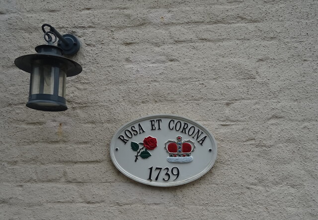
Sign on the  former Rose and Crown,  Allhallows
Sign on the former Rose and Crown, Allhallows
Cereal crop, Allhallows
Bend in the lane, Allhallows
Golf course, Allhallows-on-Sea
Track (footpath) to Dagnam Farm
Communications tower and barn Beside Ratcliffe Highway.
Communications tower and barn
Beside Ratcliffe Highway.
Elizabeth II postbox, The Old Post Office, Allhallows Postbox No. ME3 107.
See <a href="https://www.geograph.org.uk/photo/7228215">TQ8377 : The Old Post Office, Allhallows</a> for context.
Elizabeth II postbox, The Old Post Office, Allhallows
Postbox No. ME3 107. See TQ8377 : The Old Post Office, Allhallows for context.
The Old Post Office, Allhallows Showing position of Postbox No. ME3 107.
See <a href="https://www.geograph.org.uk/photo/7228214">TQ8377 : Elizabeth II postbox, The Old Post Office, Allhallows</a> for postbox.
The Old Post Office, Allhallows
Showing position of Postbox No. ME3 107. See TQ8377 : Elizabeth II postbox, The Old Post Office, Allhallows for postbox.
Allhallows Yacht Club This is This is Allhallows Yacht Club on the River Thames. For more info see  <span class="nowrap"><a title="http://www.noblemarine.co.uk/clubs/name/Allhallows-Yacht-Club-Ltd/" rel="nofollow ugc noopener" href="http://www.noblemarine.co.uk/clubs/name/Allhallows-Yacht-Club-Ltd/">Link</a><img style="margin-left:2px;" alt="External link" title="External link - shift click to open in new window" src="https://s1.geograph.org.uk/img/external.png" width="10" height="10"/></span>
Allhallows Yacht Club
This is This is Allhallows Yacht Club on the River Thames. For more info see LinkExternal link
Allhallows Pillbox This pillbox is on the beach to the west of Allhallows-on-Sea Kent. It appears to be a bit taller than normal probably due to erosion of the sand on which it was built. You can see Canvey Island across the river and the hills of Benfleet behind that.
Allhallows Pillbox
This pillbox is on the beach to the west of Allhallows-on-Sea Kent. It appears to be a bit taller than normal probably due to erosion of the sand on which it was built. You can see Canvey Island across the river and the hills of Benfleet behind that.
New Homes in Allhallows Infill housing on the corner of All Saints Road Allhallows Kent
New Homes in Allhallows
Infill housing on the corner of All Saints Road Allhallows Kent
The British Pilot The pub name describes a nautical rather than an aerial pilot since the River Thames (or the mud flats thereof) is only a few hundred yards away. This pub was intended to be part of an holiday resort to rival Southend-on-Sea just across the water. <span class="nowrap"><a title="http://en.wikipedia.org/wiki/Allhallows,_Kent" rel="nofollow ugc noopener" href="http://en.wikipedia.org/wiki/Allhallows,_Kent">Link</a><img style="margin-left:2px;" alt="External link" title="External link - shift click to open in new window" src="https://s1.geograph.org.uk/img/external.png" width="10" height="10"/></span> But it never came off.
The British Pilot
The pub name describes a nautical rather than an aerial pilot since the River Thames (or the mud flats thereof) is only a few hundred yards away. This pub was intended to be part of an holiday resort to rival Southend-on-Sea just across the water. LinkExternal link But it never came off.
Yantlet Creek The green fence is around the top of the sluices which control the drainage from Allhallows Marshes. In the distance are the storage tanks for the oil-fired Grain power station. 

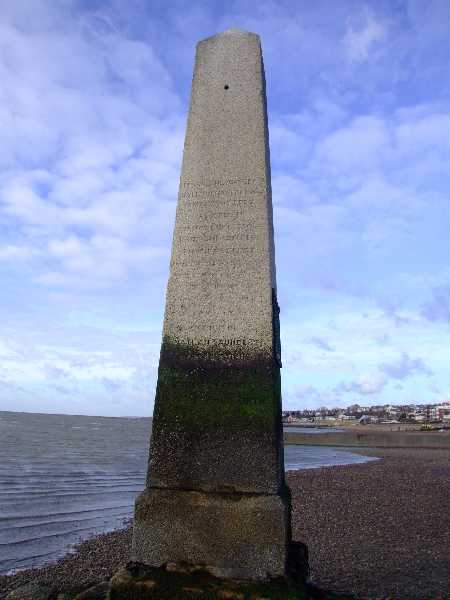
The stone in the foreground may look like a gravestone but the text on it is: "Southern Water Authority, Kent Division. This stone commemorating the completion of the raising of the Thames Flood Defences between 1975 - 1985 was unveiled by Mr H.J.L. Harris, chairman, Regional Land Drainage Committee on the 1st May 1986".

In fact only a few yards away there is a memorial stone to "Geoffrey John Hammond, artist, teacher, naturalist, conservationist drowned on 2 March 1975 in these waters".
Yantlet Creek
The green fence is around the top of the sluices which control the drainage from Allhallows Marshes. In the distance are the storage tanks for the oil-fired Grain power station. The stone in the foreground may look like a gravestone but the text on it is: "Southern Water Authority, Kent Division. This stone commemorating the completion of the raising of the Thames Flood Defences between 1975 - 1985 was unveiled by Mr H.J.L. Harris, chairman, Regional Land Drainage Committee on the 1st May 1986". In fact only a few yards away there is a memorial stone to "Geoffrey John Hammond, artist, teacher, naturalist, conservationist drowned on 2 March 1975 in these waters".
Beacon at sunset
Beacon at sunset
Show me another place!

Allhallows is located at Grid Ref: TQ8379 (Lat: 51.48042, Lng: 0.647144)

Unitary Authority: Medway

Police Authority: Kent

What 3 Words

///walks.reinforce.fidgeting. Near Allhallows, Kent

Nearby Locations

Allhallows

Related Wikis

Nearby Amenities

Located within 500m of 51.48042,0.647144
Traffic Calming: bump
Lat/Long: 51.4787251/0.6452325
Traffic Calming: bump
Lat/Long: 51.4783107/0.6462101
Traffic Calming: bump
Lat/Long: 51.4767406/0.6433203
Traffic Calming: bump
Lat/Long: 51.4772808/0.6433901
Turning Circle
Turning Circle: hammer
Lat/Long: 51.478141/0.6419042
Turning Circle
Turning Circle: hammer
Lat/Long: 51.4782359/0.6424942
Restaurant
Huffkin of Hoo
Addr City: Rochester
Addr Place: Allhallows Holiday Park
Addr Postcode: ME3 9QD
Addr Village: Allhallows
Fhrs Id: 580532
Source Addr: FHRS Open Data
Lat/Long: 51.4773763/0.6446522
Fast Food
Burger King
Addr City: Rochester
Addr Place: Allhallows Holiday Park
Addr Postcode: ME3 9QD
Addr Village: Allhallows
Brand: Burger King
Brand Wikidata: Q177054
Construction: yes
Cuisine: burger
Fhrs Id: 1520296
Operator: Haven
Source Addr: FHRS Open Data
Takeaway: yes
Lat/Long: 51.4772326/0.6457385
Fast Food
Papa John's
Addr City: Rochester
Addr Place: Allhallows Holiday Park
Addr Postcode: ME3 9QD
Addr Village: Allhallows
Brand: Papa John's
Brand Wikidata: Q2759586
Cuisine: pizza
Fhrs Id: 797881
Operator: Haven
Source Addr: FHRS Open Data
Takeaway: yes
Website: https://www.papajohns.co.uk/stores/other
Lat/Long: 51.4775317/0.6448748
Leisure: amusement_arcade
Operator: Haven
Lat/Long: 51.4774865/0.645194
Access: permit
Leisure: swimming_pool
Location: indoor
Swimming Pool: indoor
Lat/Long: 51.4772376/0.6453496
Barrier: yes
Lat/Long: 51.4767866/0.6455178
Entrance: main
Lat/Long: 51.4775533/0.6453341
Entrance: main
Lat/Long: 51.4774364/0.6455413
Fast Food
Cook's Fish and Chips
Addr City: Rochester
Addr Place: Allhallows Holiday Park
Addr Postcode: ME3 9QD
Addr Village: Allhallows
Cuisine: fish_and_chips
Fhrs Id: 1526481
Operator: Haven
Source Addr: FHRS Open Data
Lat/Long: 51.4769407/0.6452651
Crossing
Crossing: unmarked
Lat/Long: 51.4763463/0.6484378
Fire Hydrant
Emergency: fire_hydrant
Water Source: main
Lat/Long: 51.4781496/0.6409469
Recycling
Recycling Type: container
Lat/Long: 51.4765327/0.6449825
Recycling
Recycling Type: container
Lat/Long: 51.4771989/0.6433623
Recycling
Recycling Type: container
Lat/Long: 51.4777225/0.6432488
Recycling
Recycling Type: container
Lat/Long: 51.4783384/0.6431854
Recycling
Recycling Type: container
Lat/Long: 51.4782787/0.6424439
Recycling
Recycling Type: container
Lat/Long: 51.4781243/0.6409497
Recycling
Recycling Type: container
Lat/Long: 51.4786227/0.6418052
Recycling
Recycling Type: container
Lat/Long: 51.4786347/0.6423199
Traffic Calming: bump
Lat/Long: 51.4785477/0.640731
Recycling
Recycling Type: container
Lat/Long: 51.4760998/0.6452047
Fire Hydrant
Emergency: fire_hydrant
Water Source: main
Lat/Long: 51.4761089/0.6451711
Fire Hydrant
Emergency: fire_hydrant
Water Source: main
Lat/Long: 51.4765329/0.6450325
Fire Hydrant
Emergency: fire_hydrant
Water Source: main
Lat/Long: 51.4778047/0.6427047
Fire Hydrant
Emergency: fire_hydrant
Water Source: main
Lat/Long: 51.4777242/0.6421831
Fixme: Number 26 is missing from satellite. There are some extra buildings shown in satellite that differs to the site map.
Lat/Long: 51.4774879/0.6420936
Traffic Calming: bump
Lat/Long: 51.4777805/0.6432715
Fire Hydrant
Emergency: fire_hydrant
Water Source: main
Lat/Long: 51.4782223/0.6418232
Fire Hydrant
Emergency: fire_hydrant
Water Source: main
Lat/Long: 51.4783517/0.6423474
Fixme: Satellite imagery shows 2 static caravans here but the site map shows 3. Unknown numbering of caravans 62, 63, and 64.
Lat/Long: 51.4780137/0.64171
Fire Hydrant
Emergency: fire_hydrant
Water Source: main
Lat/Long: 51.47656/0.6441166
Fire Hydrant
Emergency: fire_hydrant
Water Source: main
Lat/Long: 51.4776845/0.6438388
Fire Hydrant
Emergency: fire_hydrant
Water Source: main
Lat/Long: 51.4780439/0.643638
Fire Hydrant
Emergency: fire_hydrant
Water Source: main
Lat/Long: 51.478393/0.6440214
Fire Hydrant
Emergency: fire_hydrant
Water Source: main
Lat/Long: 51.4785719/0.643514
Recycling
Recycling Type: container
Lat/Long: 51.4759423/0.6470778
Recycling
Recycling Type: container
Lat/Long: 51.4760027/0.646258
Fire Hydrant
Emergency: fire_hydrant
Water Source: main
Lat/Long: 51.4759737/0.646239
Traffic Calming: bump
Lat/Long: 51.4772248/0.647789
Traffic Calming: bump
Lat/Long: 51.4773336/0.6476988
Traffic Calming: bump
Lat/Long: 51.4781152/0.6465969
Traffic Calming: bump
Lat/Long: 51.4778621/0.647068
Traffic Calming: bump
Lat/Long: 51.4776401/0.6474835
Fire Hydrant
Emergency: fire_hydrant
Water Source: main
Lat/Long: 51.4768646/0.6490071
Fire Hydrant
Emergency: fire_hydrant
Water Source: main
Lat/Long: 51.4771579/0.647898
Fire Hydrant
Emergency: fire_hydrant
Water Source: main
Lat/Long: 51.4766259/0.6496999
Traffic Calming: bump
Lat/Long: 51.4769106/0.6489688
Traffic Calming: bump
Lat/Long: 51.4765784/0.6498705
Fixme: I think there is some conflict with old and new data.
Lat/Long: 51.4771771/0.6459134
Traffic Calming: bump
Lat/Long: 51.4765837/0.6435111
Traffic Calming: bump
Lat/Long: 51.4767493/0.6438986
Traffic Calming: bump
Lat/Long: 51.4768934/0.6435616
Traffic Calming: bump
Lat/Long: 51.4766415/0.6457385
Traffic Calming: bump
Lat/Long: 51.4787465/0.6429102
Traffic Calming: bump
Lat/Long: 51.4786641/0.6414841
Give Way
Direction: forward
Lat/Long: 51.4763705/0.6454477
Give Way
Direction: forward
Lat/Long: 51.4765915/0.6451954
Give Way
Direction: forward
Lat/Long: 51.4766876/0.6452174
The data included in this document is from www.openstreetmap.org. The data is made available under ODbL.

Have you been to Allhallows?

Leave your review of Allhallows below (or comments, questions and feedback).