Brierley

Settlement in Herefordshire

England

Brierley

Coal train passing B4361at Ford Bridge
Coal train passing B4361at Ford Bridge Credit: Colin Pyle

Brierley is a small village located in the county of Herefordshire, England. Situated in the scenic countryside, it is surrounded by rolling hills, lush green fields, and picturesque landscapes. The village is part of the civil parish of Humber, nestled between the larger towns of Leominster and Ludlow.

With a population of around 300 residents, Brierley maintains a close-knit community atmosphere. The village is characterized by its charming rural architecture, featuring traditional stone houses and cottages. The local church, St. Peter's, stands as a prominent landmark and dates back to the 13th century, showcasing the area's rich history.

Agriculture plays a vital role in Brierley's economy, with many residents involved in farming and livestock rearing. The fertile soil and favorable climate in the region make it suitable for cultivating crops such as wheat, barley, and fruits. The village is also known for its local produce, including dairy products and homemade jams.

Despite its small size, Brierley offers a range of amenities to its residents. These include a village hall, a primary school, and a post office. The surrounding area provides ample opportunities for outdoor activities, such as hiking, cycling, and nature walks. Additionally, the village is well-connected to nearby towns and cities via road networks, providing easy access for commuting and transportation.

Brierley offers a tranquil and idyllic setting, making it an attractive destination for those seeking a peaceful countryside lifestyle. Its natural beauty, strong community spirit, and historical heritage make it a cherished location within Herefordshire.

If you have any feedback on the listing, please let us know in the comments section below.
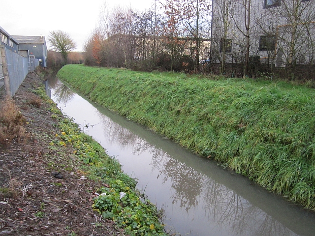
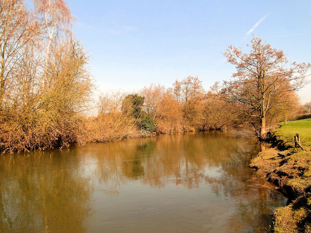
Brierley Images

Images are sourced within 2km of 52.200283/-2.7387621 or Grid Reference SO4956. Thanks to Geograph Open Source API. All images are credited.

Coal train passing B4361at Ford Bridge
Hereford Road near Longmead
Drainage, Leominster A full drain between two parts of the industrial estate which has grown up on the south side of Leominster on what was flat farmland.
The fence on the left is the Post Office delivery office.
Drainage, Leominster
A full drain between two parts of the industrial estate which has grown up on the south side of Leominster on what was flat farmland. The fence on the left is the Post Office delivery office.
Arable land, Elms Green The square is not all Leominster bypass! This is a large arable area just above the floods along the Arrow. Winter planting means a lot of soil is exposed to winter rainfall and the rivers are now running red with lost soil. Nearby much of the land is under water with the A49 running along a causeway.
Arable land, Elms Green
The square is not all Leominster bypass! This is a large arable area just above the floods along the Arrow. Winter planting means a lot of soil is exposed to winter rainfall and the rivers are now running red with lost soil. Nearby much of the land is under water with the A49 running along a causeway.
Leominster Police Station Part of the West Mercia Police force, the large modern police station is in Enterprise Way, Enterprise Park, viewed from the corner of Brunel Road.
Leominster Police Station
Part of the West Mercia Police force, the large modern police station is in Enterprise Way, Enterprise Park, viewed from the corner of Brunel Road.
Leo Pest Control, Leominster Located in Sandford Court, Enterprise Way in Leominster Enterprise Park, next door to the police station. <a title="https://www.geograph.org.uk/photo/3757218" href="https://www.geograph.org.uk/photo/3757218">Link</a>
Leo Pest Control, Leominster
Located in Sandford Court, Enterprise Way in Leominster Enterprise Park, next door to the police station. Link
Leominster Police Station Part of the West Mercia Police force, the large modern police station is in Enterprise Way, Leominster Enterprise Park.
Leominster Police Station
Part of the West Mercia Police force, the large modern police station is in Enterprise Way, Leominster Enterprise Park.
Unnamed stream in Leominster Enterprise Park A tributary of the River Arrow, the stream here flows towards Southern Avenue.
Unnamed stream in Leominster Enterprise Park
A tributary of the River Arrow, the stream here flows towards Southern Avenue.
Royal Mail Delivery Office, Leominster  Viewed across Brierley Way, on the south side of Southern Avenue.
Royal Mail Delivery Office, Leominster
Viewed across Brierley Way, on the south side of Southern Avenue.
St John of Jerusalem, Ford Bridge On the banks of the Lugg and still very much alive, this small Neo-Norman church by Thomas Nicholson of 1850-1 stands on ancient foundations.
St John of Jerusalem, Ford Bridge
On the banks of the Lugg and still very much alive, this small Neo-Norman church by Thomas Nicholson of 1850-1 stands on ancient foundations.
St John of Jerusalem, Ford Bridge On the banks of the Lugg and still very much alive, this small Neo-Norman church by Thomas Nicholson of 1850-1 stands on ancient foundations. The charming interior.
St John of Jerusalem, Ford Bridge
On the banks of the Lugg and still very much alive, this small Neo-Norman church by Thomas Nicholson of 1850-1 stands on ancient foundations. The charming interior.
The Lugg at Ford Bridge The river at the foot of the bank by the church.
The Lugg at Ford Bridge
The river at the foot of the bank by the church.
St John of Jerusalem, Ford Bridge
Railway at Ford Bridge Taken from the footpath which crosses the line at this point. There used to be a proper level crossing here, but it was closed when the Leominster bypass (the road to the left of the shot) was opened. I missed a passing train, which would have added interest to this picture, by perhaps half a minute, which is entirely typical of my luck.
Railway at Ford Bridge
Taken from the footpath which crosses the line at this point. There used to be a proper level crossing here, but it was closed when the Leominster bypass (the road to the left of the shot) was opened. I missed a passing train, which would have added interest to this picture, by perhaps half a minute, which is entirely typical of my luck.
Ford Bridge railway station The old station at Ford, long closed and now used as a private residence. The old platform edge can just be made out in front of the house. The old and new alignments of the A49 can be seen running either side of the railway. The station was closed in 1954.
Ford Bridge railway station
The old station at Ford, long closed and now used as a private residence. The old platform edge can just be made out in front of the house. The old and new alignments of the A49 can be seen running either side of the railway. The station was closed in 1954.
Ford Bridge station house Another shot of the old railway station at Ford in Hereford (yes, the village is called Ford but the station was called Ford Bridge. I don't know why). Taken from the old A49, now a B road.
Ford Bridge station house
Another shot of the old railway station at Ford in Hereford (yes, the village is called Ford but the station was called Ford Bridge. I don't know why). Taken from the old A49, now a B road.
Stone farm Mid way between Stoke Prior and Ford Bridge safely above the Lugg floodplain.
Stone farm
Mid way between Stoke Prior and Ford Bridge safely above the Lugg floodplain.
Show me another place!

Brierley is located at Grid Ref: SO4956 (Lat: 52.200283, Lng: -2.7387621)

Unitary Authority: County of Herefordshire

Police Authority: West Mercia

What 3 Words

///begin.roadblock.younger. Near Hope under Dinmore, Herefordshire

Nearby Locations

Brierley

Related Wikis

Broadward, Herefordshire

Broadward is a hamlet in Herefordshire, England. It is situated approximately 1 mile (1.6 km) south of the town of Leominster, on the B4361 road (Hereford...

Ford Bridge railway station

Ford Bridge railway station was a station in Marlbrook, Herefordshire, England. The station was opened in 1854 and closed in 1954. After closure, the station...

River Arrow, Wales

The River Arrow (Welsh: Afon Arwy) is a river in the Welsh Marches, rising in Powys in Wales, then flowing into the English county of Herefordshire. It...

Ivington Camp

Ivington Camp is an Iron Age hill fort located at Brierley, 3 km south of Leominster, Herefordshire. == Further reading == Children, G; Nash, G (1994)...

Marlbrook, Herefordshire

Marlbrook is an industrial and business park on the borders of and split between the civil parishes of Hope under Dinmore and Newton, in Herefordshire...

Leominster (district)

Leominster was a non-metropolitan district in Hereford and Worcester, England from 1974 to 1998. The council was based in the town of Leominster. ��2...

Ivington

Ivington () is a village in the county of Herefordshire, England, approximately 13 miles (21 km) north of Hereford. It is about 2 miles (3 km) south-west...

Eaton Hall, Herefordshire

Eaton Hall is a two-storey building in Leominster in Herefordshire, 1 mile to the south-east of the village church. It was historically sited in the parish...

Related Videos

Walking from Grange Court to Eaton Barns.

This walk is a lovely flat walk from Leominster to Eaton Barns. it's one of the more accessible walks we have in Leominster. there ...

MLC trip to Dom's Bike Stop. Quick taster

A quick intro for the next video of our Sunday morning ride out. MLC take to the Mway (much to Verbals disgust) and then onto the ...

Nearby Amenities

Located within 500m of 52.200283,-2.7387621
Brierley
Place: hamlet
Lat/Long: 52.2000524/-2.7389419
Power: pole
Source: bing
Lat/Long: 52.1991278/-2.7325675
Power: pole
Source: bing
Lat/Long: 52.1999844/-2.7331549
Power: pole
Source: bing
Lat/Long: 52.2009806/-2.7338281
Power: pole
Source: bing
Lat/Long: 52.201819/-2.7344424
Power: pole
Source: bing
Lat/Long: 52.2040398/-2.7408126
Power: pole
Source: bing
Lat/Long: 52.2036801/-2.7392013
Power: pole
Source: bing
Lat/Long: 52.2032968/-2.7375671
Power: pole
Source: bing
Lat/Long: 52.2029138/-2.735998
Power: pole
Source: bing
Lat/Long: 52.2026803/-2.7350861
The data included in this document is from www.openstreetmap.org. The data is made available under ODbL.

Have you been to Brierley?

Leave your review of Brierley below (or comments, questions and feedback).