Abaty Cwm-hir

Community in Radnorshire

Wales

Abaty Cwm-hir

Glyndwr's Way near Tyfaenor Park
Glyndwr's Way near Tyfaenor Park Credit: Dave Kelly

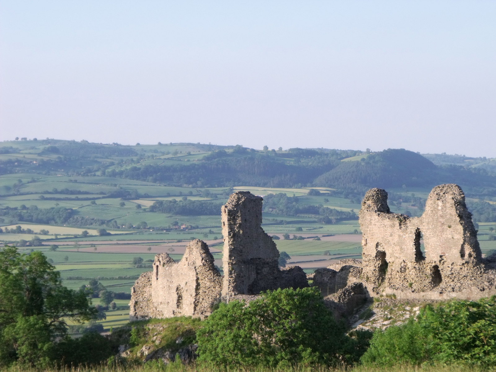
Abaty Cwm-hir is a small community located in the county of Radnorshire, Wales. It is situated in the heart of the scenic Cambrian Mountains, providing breathtaking views of the surrounding countryside. The community is named after the nearby Cwm-hir Abbey, a Cistercian monastery which was founded in the 12th century.

The landscape of Abaty Cwm-hir is characterized by rolling hills, lush green valleys, and an abundance of wildlife. It is a popular destination for nature lovers, hikers, and outdoor enthusiasts who enjoy exploring the numerous walking trails and cycle routes in the area. The community is also home to several ancient sites, including standing stones, burial mounds, and hillforts, which offer a glimpse into its rich history.

Abaty Cwm-hir boasts a close-knit community, with a small population of friendly and welcoming residents. It offers a peaceful and tranquil atmosphere, making it an ideal place for those seeking a retreat from the hustle and bustle of city life. Despite its rural setting, the community is well-connected to nearby towns and villages, with amenities such as shops, pubs, and schools within easy reach.

Visitors to Abaty Cwm-hir can enjoy a range of activities, including fishing in the local rivers, exploring the nearby Elan Valley reservoirs, or simply taking in the breathtaking scenery. The community also hosts various events and festivals throughout the year, celebrating its cultural heritage and providing entertainment for both locals and tourists alike. Overall, Abaty Cwm-hir offers a unique blend of natural beauty, historical significance, and community spirit, making it a hidden gem in the heart of Radnorshire.

If you have any feedback on the listing, please let us know in the comments section below.

Abaty Cwm-hir Images

Images are sourced within 2km of 52.328368/-3.370157 or Grid Reference SO0670. Thanks to Geograph Open Source API. All images are credited.

Glyndwr's Way near Tyfaenor Park
Glyndwr's Way near Abbeycwmhir
Bridge over Cwm Poeth Brook at Abbeycwmhir This stone bridge allows access to St Mary's churchyard from the nearby hall. The single-span footbridge with its attached walls is grade II-listed (Cadw Building ID: 83092 <span class="nowrap"><a title="http://www.britishlistedbuildings.co.uk/wa-83092-footbridge-attached-walls-and-gateway-on-#.VxPdcP_mqHs" rel="nofollow ugc noopener" href="http://www.britishlistedbuildings.co.uk/wa-83092-footbridge-attached-walls-and-gateway-on-#.VxPdcP_mqHs">Link</a><img style="margin-left:2px;" alt="External link" title="External link - shift click to open in new window" src="https://s1.geograph.org.uk/img/external.png" width="10" height="10"/></span>  British Listed Buildings)
Bridge over Cwm Poeth Brook at Abbeycwmhir
This stone bridge allows access to St Mary's churchyard from the nearby hall. The single-span footbridge with its attached walls is grade II-listed (Cadw Building ID: 83092 LinkExternal link British Listed Buildings)
Parish Church of St Mary, Abbeycwmhir The current church was built in 1856 at the expense of Miss Mary Beatrice Philips, a sister to the Squire George Henry Philips of the adjacent Hall <a title="https://www.geograph.org.uk/photo/1445756" href="https://www.geograph.org.uk/photo/1445756">Link</a>. 
The current building, in Victorian Gothic revival style, replaced that built in 1680 by Sir William Fowler a little to the south, of which no trace remains. The earlier building which was dedicated to St Bridget incorporated carved stonework from the nearby Abbey none of which has been preserved in this church.
Cwm Poeth brook runs through the churchyard and into a culvert under the road, eventually emerging below Home Farm before joining Clywedog Brook. A stone bridge leads over Cwm Poeth from the churchyard to The Hall.

Clwyd Powys Archaeological Trust Radnorshire churches survey <span class="nowrap"><a title="https://cpat.org.uk/Archive/churches/radnor/16703.htm" rel="nofollow ugc noopener" href="https://cpat.org.uk/Archive/churches/radnor/16703.htm">Link</a><img style="margin-left:2px;" alt="External link" title="External link - shift click to open in new window" src="https://s1.geograph.org.uk/img/external.png" width="10" height="10"/></span>
Castles of Wales page <span class="nowrap"><a title="http://www.castlewales.com/cwmhr_ch.html" rel="nofollow ugc noopener" href="http://www.castlewales.com/cwmhr_ch.html">Link</a><img style="margin-left:2px;" alt="External link" title="External link - shift click to open in new window" src="https://s1.geograph.org.uk/img/external.png" width="10" height="10"/></span>

The church, bridge and Abbey ruins are all listed Grade II*.
Parish Church of St Mary, Abbeycwmhir
The current church was built in 1856 at the expense of Miss Mary Beatrice Philips, a sister to the Squire George Henry Philips of the adjacent Hall Link. The current building, in Victorian Gothic revival style, replaced that built in 1680 by Sir William Fowler a little to the south, of which no trace remains. The earlier building which was dedicated to St Bridget incorporated carved stonework from the nearby Abbey none of which has been preserved in this church. Cwm Poeth brook runs through the churchyard and into a culvert under the road, eventually emerging below Home Farm before joining Clywedog Brook. A stone bridge leads over Cwm Poeth from the churchyard to The Hall. Clwyd Powys Archaeological Trust Radnorshire churches survey LinkExternal link Castles of Wales page LinkExternal link The church, bridge and Abbey ruins are all listed Grade II*.
Railings Detail, St Mary's Church, Abbeycwmhir The current church was built in 1856 at the expense of Miss Mary Beatrice Philips, a sister to the Squire George Henry Philips of the adjacent Hall <a title="https://www.geograph.org.uk/photo/1445756" href="https://www.geograph.org.uk/photo/1445756">Link</a>. 
The current building, in Victorian Gothic revival style, replaced that built in 1680 by Sir William Fowler a little to the south, of which no trace remains. The earlier building which was dedicated to St Bridget incorporated carved stonework from the nearby Abbey none of which has been preserved in this church.
Cwm Poeth brook runs through the churchyard and into a culvert under the road, eventually emerging below Home Farm before joining Clywedog Brook. A stone bridge leads over Cwm Poeth from the churchyard to The Hall.

Clwyd Powys Archaeological Trust Radnorshire churches survey <span class="nowrap"><a title="https://cpat.org.uk/Archive/churches/radnor/16703.htm" rel="nofollow ugc noopener" href="https://cpat.org.uk/Archive/churches/radnor/16703.htm">Link</a><img style="margin-left:2px;" alt="External link" title="External link - shift click to open in new window" src="https://s1.geograph.org.uk/img/external.png" width="10" height="10"/></span>
Castles of Wales page <span class="nowrap"><a title="http://www.castlewales.com/cwmhr_ch.html" rel="nofollow ugc noopener" href="http://www.castlewales.com/cwmhr_ch.html">Link</a><img style="margin-left:2px;" alt="External link" title="External link - shift click to open in new window" src="https://s1.geograph.org.uk/img/external.png" width="10" height="10"/></span>

The church, bridge and Abbey ruins are all listed Grade II*.
Railings Detail, St Mary's Church, Abbeycwmhir
The current church was built in 1856 at the expense of Miss Mary Beatrice Philips, a sister to the Squire George Henry Philips of the adjacent Hall Link. The current building, in Victorian Gothic revival style, replaced that built in 1680 by Sir William Fowler a little to the south, of which no trace remains. The earlier building which was dedicated to St Bridget incorporated carved stonework from the nearby Abbey none of which has been preserved in this church. Cwm Poeth brook runs through the churchyard and into a culvert under the road, eventually emerging below Home Farm before joining Clywedog Brook. A stone bridge leads over Cwm Poeth from the churchyard to The Hall. Clwyd Powys Archaeological Trust Radnorshire churches survey LinkExternal link Castles of Wales page LinkExternal link The church, bridge and Abbey ruins are all listed Grade II*.
Abbey-Cwm-Hir Abbeycwmhir (Abaty Cwm Hir, "Abbey in the Long Valley") is a remote village in the valley of the Nant Clywedog. The village is named after Cwmhir Abbey, the Cistercian abbey built there in 1143.
Abbey-Cwm-Hir
Abbeycwmhir (Abaty Cwm Hir, "Abbey in the Long Valley") is a remote village in the valley of the Nant Clywedog. The village is named after Cwmhir Abbey, the Cistercian abbey built there in 1143.
Abbeycwmhir Village Centre Abbeycwmhir (Abaty Cwm Hir, "Abbey in the Long Valley") is a remote village in the valley of the Nant Clywedog. The village is named after Cwmhir Abbey, the Cistercian abbey built there in 1143.
Abbeycwmhir Village Centre
Abbeycwmhir (Abaty Cwm Hir, "Abbey in the Long Valley") is a remote village in the valley of the Nant Clywedog. The village is named after Cwmhir Abbey, the Cistercian abbey built there in 1143.
Abbeycwmhir Telephone Kiosk Abbeycwmhir (Abaty Cwm Hir, "Abbey in the Long Valley") is a remote village in the valley of the Nant Clywedog. The village is named after Cwmhir Abbey, the Cistercian abbey built there in 1143.
Abbeycwmhir Telephone Kiosk
Abbeycwmhir (Abaty Cwm Hir, "Abbey in the Long Valley") is a remote village in the valley of the Nant Clywedog. The village is named after Cwmhir Abbey, the Cistercian abbey built there in 1143.
Cwmhir Abbey (Abaty Cwm Hir) The ruins of Abbey Cwmhir lie in the secluded valley of the Clywedog brook in a remote location typical of those chosen by the Cistercian order. The abbey was built in 1176, probably under the patronage of Cadwallon ap Madog of Maelienydd, as this area of Powys was then called.
The abbey was badly damaged in 1401-2 during the revolt of Owen Glyndwr who believed the English monks to be spies. At the time of dissolution in 1537 there were only three monks here.
Little survives of the abbey buildings and only the nave of the church, the largest in Wales,  still stands. Stone from the abbey was used in the construction of the 17th century church (since demolished) and The Hall.
The nearby mound and boating lake are part of the 19th century landscaping around the adjacent Hall <a title="https://www.geograph.org.uk/photo/1445756" href="https://www.geograph.org.uk/photo/1445756">Link</a>.

Clwyd Powys Archaeological Trust <span class="nowrap"><a title="http://www.cpat.org.uk/projects/longer/abbeyc/abbeyc.htm" rel="nofollow ugc noopener" href="http://www.cpat.org.uk/projects/longer/abbeyc/abbeyc.htm">Link</a><img style="margin-left:2px;" alt="External link" title="External link - shift click to open in new window" src="https://s1.geograph.org.uk/img/external.png" width="10" height="10"/></span>
Castles of Wales page <span class="nowrap"><a title="http://www.castlewales.com/cwmhir.html" rel="nofollow ugc noopener" href="http://www.castlewales.com/cwmhir.html">Link</a><img style="margin-left:2px;" alt="External link" title="External link - shift click to open in new window" src="https://s1.geograph.org.uk/img/external.png" width="10" height="10"/></span>

The abbey ruins are Grade II* listed.
Cwmhir Abbey (Abaty Cwm Hir)
The ruins of Abbey Cwmhir lie in the secluded valley of the Clywedog brook in a remote location typical of those chosen by the Cistercian order. The abbey was built in 1176, probably under the patronage of Cadwallon ap Madog of Maelienydd, as this area of Powys was then called. The abbey was badly damaged in 1401-2 during the revolt of Owen Glyndwr who believed the English monks to be spies. At the time of dissolution in 1537 there were only three monks here. Little survives of the abbey buildings and only the nave of the church, the largest in Wales, still stands. Stone from the abbey was used in the construction of the 17th century church (since demolished) and The Hall. The nearby mound and boating lake are part of the 19th century landscaping around the adjacent Hall Link. Clwyd Powys Archaeological Trust LinkExternal link Castles of Wales page LinkExternal link The abbey ruins are Grade II* listed.
Cistercian Abbey Ruins, Cwmhir Abbey (Abaty Cwm Hir) The ruins of Abbey Cwmhir lie in the secluded valley of the Clywedog brook in a remote location typical of those chosen by the Cistercian order. The abbey was built in 1176, probably under the patronage of Cadwallon ap Madog of Maelienydd, as this area of Powys was then called.
The abbey was badly damaged in 1401-2 during the revolt of Owen Glyndwr who believed the English monks to be spies. At the time of dissolution in 1537 there were only three monks here.
Little survives of the abbey buildings and only the nave of the church, the largest in Wales,  still stands. Stone from the abbey was used in the construction of the 17th century church (since demolished) and The Hall.
The nearby mound and boating lake are part of the 19th century landscaping around the adjacent Hall <a title="https://www.geograph.org.uk/photo/1445756" href="https://www.geograph.org.uk/photo/1445756">Link</a>.

Clwyd Powys Archaeological Trust <span class="nowrap"><a title="http://www.cpat.org.uk/projects/longer/abbeyc/abbeyc.htm" rel="nofollow ugc noopener" href="http://www.cpat.org.uk/projects/longer/abbeyc/abbeyc.htm">Link</a><img style="margin-left:2px;" alt="External link" title="External link - shift click to open in new window" src="https://s1.geograph.org.uk/img/external.png" width="10" height="10"/></span>
Castles of Wales page <span class="nowrap"><a title="http://www.castlewales.com/cwmhir.html" rel="nofollow ugc noopener" href="http://www.castlewales.com/cwmhir.html">Link</a><img style="margin-left:2px;" alt="External link" title="External link - shift click to open in new window" src="https://s1.geograph.org.uk/img/external.png" width="10" height="10"/></span>

The abbey ruins are Grade II* listed.
Cistercian Abbey Ruins, Cwmhir Abbey (Abaty Cwm Hir)
The ruins of Abbey Cwmhir lie in the secluded valley of the Clywedog brook in a remote location typical of those chosen by the Cistercian order. The abbey was built in 1176, probably under the patronage of Cadwallon ap Madog of Maelienydd, as this area of Powys was then called. The abbey was badly damaged in 1401-2 during the revolt of Owen Glyndwr who believed the English monks to be spies. At the time of dissolution in 1537 there were only three monks here. Little survives of the abbey buildings and only the nave of the church, the largest in Wales, still stands. Stone from the abbey was used in the construction of the 17th century church (since demolished) and The Hall. The nearby mound and boating lake are part of the 19th century landscaping around the adjacent Hall Link. Clwyd Powys Archaeological Trust LinkExternal link Castles of Wales page LinkExternal link The abbey ruins are Grade II* listed.
Cwmhir Abbey (Abaty Cwm Hir) Ruins The remains of the Cistercian abbey, viewed from the south-east.
Cwmhir Abbey (Abaty Cwm Hir) Ruins
The remains of the Cistercian abbey, viewed from the south-east.
Lake at Abbey-Cwm-Hir The lake, just to the south of the ruined abbey, was built as part of the 19th century landscaping associated with the nearby hall.
Lake at Abbey-Cwm-Hir
The lake, just to the south of the ruined abbey, was built as part of the 19th century landscaping associated with the nearby hall.
Clywedog Brook at Abbey-Cwm-Hir Water drains from the lake into Clywedog Brook.
Clywedog Brook at Abbey-Cwm-Hir
Water drains from the lake into Clywedog Brook.
Lake and Ruined Abbey, Abbey-Cwm-Hir The ruins of Abbey Cwmhir lie in the secluded valley of the Clywedog brook in a remote location typical of those chosen by the Cistercian order. The abbey was built in 1176, probably under the patronage of Cadwallon ap Madog of Maelienydd, as this area of Powys was then called.
The abbey was badly damaged in 1401-2 during the revolt of Owen Glyndwr who believed the English monks to be spies. At the time of dissolution in 1537 there were only three monks here.
Little survives of the abbey buildings and only the nave of the church, the largest in Wales,  still stands. Stone from the abbey was used in the construction of the 17th century church (since demolished) and The Hall.
The nearby mound and boating lake are part of the 19th century landscaping around the adjacent Hall <a title="https://www.geograph.org.uk/photo/1445756" href="https://www.geograph.org.uk/photo/1445756">Link</a>.

Clwyd Powys Archaeological Trust <span class="nowrap"><a title="http://www.cpat.org.uk/projects/longer/abbeyc/abbeyc.htm" rel="nofollow ugc noopener" href="http://www.cpat.org.uk/projects/longer/abbeyc/abbeyc.htm">Link</a><img style="margin-left:2px;" alt="External link" title="External link - shift click to open in new window" src="https://s1.geograph.org.uk/img/external.png" width="10" height="10"/></span>
Castles of Wales page <span class="nowrap"><a title="http://www.castlewales.com/cwmhir.html" rel="nofollow ugc noopener" href="http://www.castlewales.com/cwmhir.html">Link</a><img style="margin-left:2px;" alt="External link" title="External link - shift click to open in new window" src="https://s1.geograph.org.uk/img/external.png" width="10" height="10"/></span>

The abbey ruins are Grade II* listed.
Lake and Ruined Abbey, Abbey-Cwm-Hir
The ruins of Abbey Cwmhir lie in the secluded valley of the Clywedog brook in a remote location typical of those chosen by the Cistercian order. The abbey was built in 1176, probably under the patronage of Cadwallon ap Madog of Maelienydd, as this area of Powys was then called. The abbey was badly damaged in 1401-2 during the revolt of Owen Glyndwr who believed the English monks to be spies. At the time of dissolution in 1537 there were only three monks here. Little survives of the abbey buildings and only the nave of the church, the largest in Wales, still stands. Stone from the abbey was used in the construction of the 17th century church (since demolished) and The Hall. The nearby mound and boating lake are part of the 19th century landscaping around the adjacent Hall Link. Clwyd Powys Archaeological Trust LinkExternal link Castles of Wales page LinkExternal link The abbey ruins are Grade II* listed.
Abaty Cwm Hir (Cwmhir Abbey) Ruins and Lake The ruins of Abbey Cwmhir lie in the secluded valley of the Clywedog brook in a remote location typical of those chosen by the Cistercian order. The abbey was built in 1176, probably under the patronage of Cadwallon ap Madog of Maelienydd, as this area of Powys was then called.
The abbey was badly damaged in 1401-2 during the revolt of Owen Glyndwr who believed the English monks to be spies. At the time of dissolution in 1537 there were only three monks here.
Little survives of the abbey buildings and only the nave of the church, the largest in Wales,  still stands. Stone from the abbey was used in the construction of the 17th century church (since demolished) and The Hall.
The nearby mound and boating lake are part of the 19th century landscaping around the adjacent Hall <a title="https://www.geograph.org.uk/photo/1445756" href="https://www.geograph.org.uk/photo/1445756">Link</a>.

Clwyd Powys Archaeological Trust <span class="nowrap"><a title="http://www.cpat.org.uk/projects/longer/abbeyc/abbeyc.htm" rel="nofollow ugc noopener" href="http://www.cpat.org.uk/projects/longer/abbeyc/abbeyc.htm">Link</a><img style="margin-left:2px;" alt="External link" title="External link - shift click to open in new window" src="https://s1.geograph.org.uk/img/external.png" width="10" height="10"/></span>
Castles of Wales page <span class="nowrap"><a title="http://www.castlewales.com/cwmhir.html" rel="nofollow ugc noopener" href="http://www.castlewales.com/cwmhir.html">Link</a><img style="margin-left:2px;" alt="External link" title="External link - shift click to open in new window" src="https://s1.geograph.org.uk/img/external.png" width="10" height="10"/></span>

The abbey ruins are Grade II* listed.
Abaty Cwm Hir (Cwmhir Abbey) Ruins and Lake
The ruins of Abbey Cwmhir lie in the secluded valley of the Clywedog brook in a remote location typical of those chosen by the Cistercian order. The abbey was built in 1176, probably under the patronage of Cadwallon ap Madog of Maelienydd, as this area of Powys was then called. The abbey was badly damaged in 1401-2 during the revolt of Owen Glyndwr who believed the English monks to be spies. At the time of dissolution in 1537 there were only three monks here. Little survives of the abbey buildings and only the nave of the church, the largest in Wales, still stands. Stone from the abbey was used in the construction of the 17th century church (since demolished) and The Hall. The nearby mound and boating lake are part of the 19th century landscaping around the adjacent Hall Link. Clwyd Powys Archaeological Trust LinkExternal link Castles of Wales page LinkExternal link The abbey ruins are Grade II* listed.
Dam, Abbeycwmhir Lake Water from the lake overflows here into Cywedog Brook.
Dam, Abbeycwmhir Lake
Water from the lake overflows here into Cywedog Brook.
Abbeycwmhir Lake The lake, just to the south of the ruined abbey, was built as part of the 19th century landscaping associated with the nearby hall.
Abbeycwmhir Lake
The lake, just to the south of the ruined abbey, was built as part of the 19th century landscaping associated with the nearby hall.
Small Waterfall on Clywedog Brook Clywedog Brook, south of the lake at Abbey-Cwm-Hir
Small Waterfall on Clywedog Brook
Clywedog Brook, south of the lake at Abbey-Cwm-Hir
Show me another place!

Abaty Cwm-hir is located at Grid Ref: SO0670 (Lat: 52.328368, Lng: -3.370157)

Unitary Authority: Powys

Police Authority: Dyfed Powys

Also known as: Abbey Cwmhir

What 3 Words

///adopt.lecturing.swerving. Near Penybont, Powys

Nearby Locations

Abaty Cwm-hir Abbey Cwmhir

Related Wikis

Abbeycwmhir

Abbeycwmhir or Abbey Cwmhir (Welsh: Abaty Cwm Hir, "Abbey in the Long Valley") is a village and community in the valley of the Nant Clywedog in Radnorshire...

Cwmhir Abbey

Cwmhir Abbey (Welsh: Abaty Cwm Hir), near Llandrindod Wells in Powys, is a Welsh Cistercian monastery founded in 1176 by Cadwallon ap Madog. A spurious...

Abbey Cwmhir Hall

Abbey-Cwm-Hir Hall is a neo-Elizabethan country house in the Welsh county of Powys. == History == The hall was built in 1833 for Thomas Wilson, a London...

Rhwng Gwy a Hafren

Rhwng Gwy a Hafren (English: Between Wye and Severn) was a region of medieval Wales, located in the Welsh Marches between Powys to the north and Brycheiniog...

Buddugre Castle

Buddugre Castle (sometimes referred to as Tomen Bedd-Ugre, Castell Cwm Aran, Tomen Bedd Turc and Bedd-y-gre) was a motte and bailey defensive fortification...

St Anno's Church, Llananno

The Church of St Anno in Llananno, Powys, Wales, is a redundant church dating from the 14th century. Its medieval rood screen is considered "one of the...

Powys

Powys ( POH-iss, POW-iss, Welsh: [ˈpou̯ɪs]) is a county and preserved county in Wales. It borders Gwynedd, Denbighshire, and Wrexham to the north; the...

Llanbister

Llanbister is a small village and community with a 2011 population of 382 in Powys, mid Wales, in the historic county of Radnorshire. == Facilities... ==

Nearby Amenities

Located within 500m of 52.328368,-3.370157
Building: yes
Lat/Long: 52.3298094/-3.3645875
Building: yes
Lat/Long: 52.3306618/-3.3638365
Direction: SE
Generator Method: photovoltaic
Generator Output Electricity: yes
Generator Solar Modules: 16
Generator Source: solar
Generator Type: solar_photovoltaic_panel
Location: roof
Power: generator
Lat/Long: 52.3306267/-3.3639364
Direction: 175
Generator Method: photovoltaic
Generator Output Electricity: yes
Generator Solar Modules: 16
Generator Source: solar
Generator Type: solar_photovoltaic_panel
Location: roof
Power: generator
Lat/Long: 52.329727/-3.3646022
Direction: 175
Generator Method: photovoltaic
Generator Output Electricity: yes
Generator Solar Modules: 16
Generator Source: solar
Generator Type: solar_photovoltaic_panel
Location: roof
Power: generator
Lat/Long: 52.3297522/-3.3646066
The data included in this document is from www.openstreetmap.org. The data is made available under ODbL.

Have you been to Abaty Cwm-hir?

Leave your review of Abaty Cwm-hir below (or comments, questions and feedback).