Walwyn's Castle

Community in Pembrokeshire

Wales

Walwyn's Castle

Walwyn's Castle and church This is the flat interior of the settlement where the livestock would be safe behind the surrounding embankments, now covered in bracken.
Walwyn's Castle and church Credit: Marion Phillips

Walwyn's Castle is a small community located in Pembrokeshire, Wales. Situated approximately 8 miles east of the town of Haverfordwest, it is a rural area surrounded by countryside and characterized by its peaceful and picturesque setting.

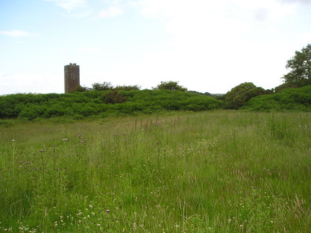
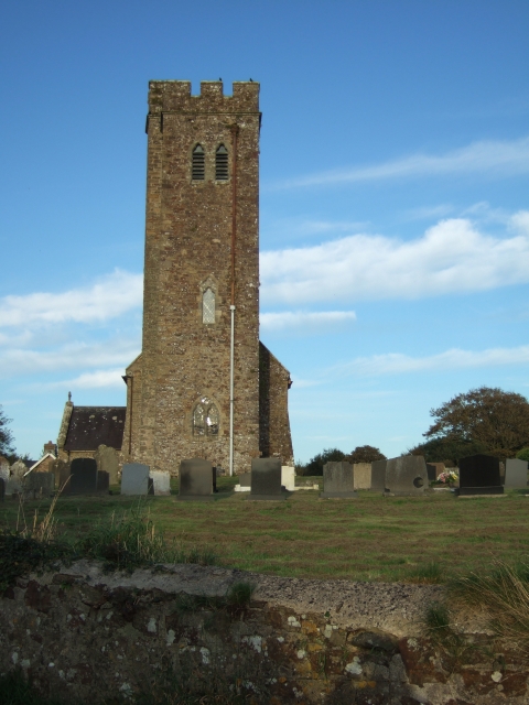
The village takes its name from the nearby castle ruins, which date back to the 13th century. Walwyn's Castle was once a medieval fortress and played a significant role in the defense of the region. Today, only the remains of the castle's walls and a circular tower can be seen, but they serve as a reminder of its historical importance.

The community itself is made up of a scattering of houses and farms, giving it a close-knit and welcoming atmosphere. The village has a small primary school, which caters to the local children, and a community hall that is used for various events and gatherings.

The surrounding countryside offers plenty of opportunities for outdoor activities, such as walking, cycling, and horse riding. The area is also known for its beautiful landscapes, with rolling hills, meandering rivers, and charming woodland.

Despite its rural location, Walwyn's Castle is conveniently situated within easy reach of amenities. The nearby town of Haverfordwest provides a range of services, including shops, supermarkets, healthcare facilities, and leisure activities.

Overall, Walwyn's Castle offers a tranquil and picturesque place to live, with a rich historical heritage and a strong sense of community.

If you have any feedback on the listing, please let us know in the comments section below.

Walwyn's Castle Images

Images are sourced within 2km of 51.748614/-5.101631 or Grid Reference SM8610. Thanks to Geograph Open Source API. All images are credited.

Walwyn's Castle and church This is the flat interior of the settlement where the livestock would be safe behind the surrounding embankments, now covered in bracken.
Walwyn's Castle and church
This is the flat interior of the settlement where the livestock would be safe behind the surrounding embankments, now covered in bracken.
Reservoir overflow This is July and the reservoir is a few inches below the level at which it would overflow.
Reservoir overflow
This is July and the reservoir is a few inches below the level at which it would overflow.
Quarry weighbridge
Quarry weighbridge
Quarry machinery Machinery for processing quarried rock and loading it onto vehicles parked below.
Quarry machinery
Machinery for processing quarried rock and loading it onto vehicles parked below.
OS benchmark - Walwyns Castle, Castle Farm An OS cutmark on the corner of a small barn at Castle Farm; originally levelled at 37.109m above Ordnance Datum Newlyn.
OS benchmark - Walwyns Castle, Castle Farm
An OS cutmark on the corner of a small barn at Castle Farm; originally levelled at 37.109m above Ordnance Datum Newlyn.
OS benchmark - Walwyns Castle church An OS cutmark on the doorpost of the church vestry; originally levelled at 48.211m above Ordnance Datum Newlyn.
OS benchmark - Walwyns Castle church
An OS cutmark on the doorpost of the church vestry; originally levelled at 48.211m above Ordnance Datum Newlyn.
St James the Great church The tower of this grade II* listed building dates from the late 14th or early 15th century, although the belfry lights and upper battlements are much more recent. It contains a medieval font, and a barrel-vaulted ceiling to the ground floor in the tower.
St James the Great church
The tower of this grade II* listed building dates from the late 14th or early 15th century, although the belfry lights and upper battlements are much more recent. It contains a medieval font, and a barrel-vaulted ceiling to the ground floor in the tower.
The Capeston Road out of Walwyns Castle A narrow lane running southwest out of Walwyns Castle, through a series of farms and small settlements. The next place of any size is Herbrandston in SM8607, just north of the oil refinery
The Capeston Road out of Walwyns Castle
A narrow lane running southwest out of Walwyns Castle, through a series of farms and small settlements. The next place of any size is Herbrandston in SM8607, just north of the oil refinery
Heading towards Syke Farm Along the lane between Walwyn's Castle and Syke Farm.
Heading towards Syke Farm
Along the lane between Walwyn's Castle and Syke Farm.
Bridleway north of Syke Farm The bridleway, used in parts as a farm track, leads north and west to the Capeston - Rosepool lane.
Bridleway north of Syke Farm
The bridleway, used in parts as a farm track, leads north and west to the Capeston - Rosepool lane.
Barns and sheds at Syke Farm Plenty of activity at the farm on the evening I ran past; photos of the main farmyard and entrance probably wouldn't have been well received.
Barns and sheds at Syke Farm
Plenty of activity at the farm on the evening I ran past; photos of the main farmyard and entrance probably wouldn't have been well received.
Bridleway to The Cotts Front entrance to The Cotts farm, which just happens also to be a public right of way.
Bridleway to The Cotts
Front entrance to The Cotts farm, which just happens also to be a public right of way.
Along Cotts Road towards Hasguard Cross
Hasguard Cross Crossroads formed by the main B4327 Dale Road, crossed by Cotts Road on the right and a nameless lane to North Leys on the left.
Hasguard Cross
Crossroads formed by the main B4327 Dale Road, crossed by Cotts Road on the right and a nameless lane to North Leys on the left.
The B4327 near Hasguard Cross A damp evening in the middle of an otherwise sunny weekend. This is the main road towards Haverfordwest from the southwest tip of Pembrokeshire.
The B4327 near Hasguard Cross
A damp evening in the middle of an otherwise sunny weekend. This is the main road towards Haverfordwest from the southwest tip of Pembrokeshire.
B4327 approaching Rosepool
Rosepool Farm A roadside farm just off the B4327 Dale Road.
Rosepool Farm
A roadside farm just off the B4327 Dale Road.
Tight bends at The Flags Tight corners (and a slippery surface) to keep drivers awake after the straights on either side of these bends.
Tight bends at The Flags
Tight corners (and a slippery surface) to keep drivers awake after the straights on either side of these bends.
Show me another place!

Walwyn's Castle is located at Grid Ref: SM8610 (Lat: 51.748614, Lng: -5.101631)

Unitary Authority: Pembrokeshire

Police Authority: Dyfed-Powys

Also known as: Castell Gwalchmai

What 3 Words

///oblige.squabbles.submitted. Near Herbrandston, Pembrokeshire

Related Wikis

Hasguard

Hasguard is a parish northwest of the town of Milford Haven in Pembrokeshire, Wales. The name applies to several other locations: Upper and Middle Hasguard...

Walwyn's Castle

Walwyn's Castle (Welsh: Castell Gwalchmai) is a village, parish and community in the county of Pembrokeshire, Wales, and is 84 miles (135 km) from Cardiff...

Herbrandston

Herbrandston is a village, parish and community on the north side of the River Cleddau, in Pembrokeshire, Wales. It is located to the west of Milford Haven...

Little and Broad Haven Lifeboat Station

Little and Broad Haven Lifeboat Station is a Royal National Lifeboat Institution (RNLI) lifeboat station in Pembrokeshire, West Wales. The station was...

Nearby Amenities

Located within 500m of 51.748614,-5.101631
Capeston
Is In: Pembrokeshire,Wales,UK
Place: hamlet
Lat/Long: 51.7463942/-5.0959018
The data included in this document is from www.openstreetmap.org. The data is made available under ODbL.

Have you been to Walwyn's Castle?

Leave your review of Walwyn's Castle below (or comments, questions and feedback).