Bridgend of Lintrathen

Settlement in Angus

Scotland

Bridgend of Lintrathen

Sand and mud flats, Loch of Lintrathen The northernmost corner of the loch where low water levels expose areas of sand and mud.
Sand and mud flats, Loch of Lintrathen Credit: Gordon Hatton

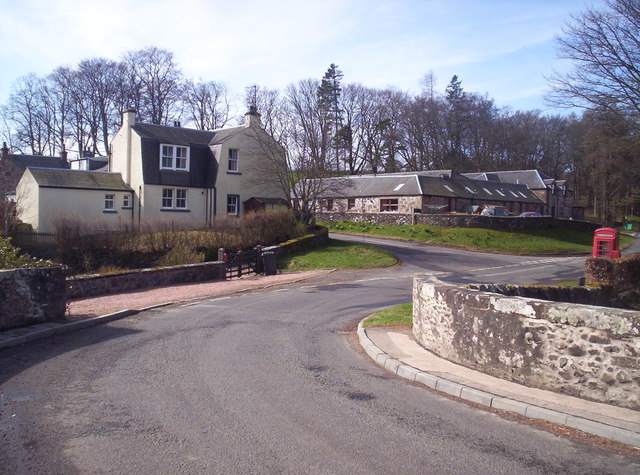
Bridgend of Lintrathen is a small village located in the county of Angus, Scotland. Situated on the southern banks of the Lintrathen Reservoir, it is surrounded by picturesque countryside and offers a tranquil setting for residents and visitors alike.

The village itself is characterized by its charming traditional stone-built houses and cottages, many of which date back several centuries. The population of Bridgend of Lintrathen is relatively small, with a close-knit community that is known for its friendly and welcoming nature.

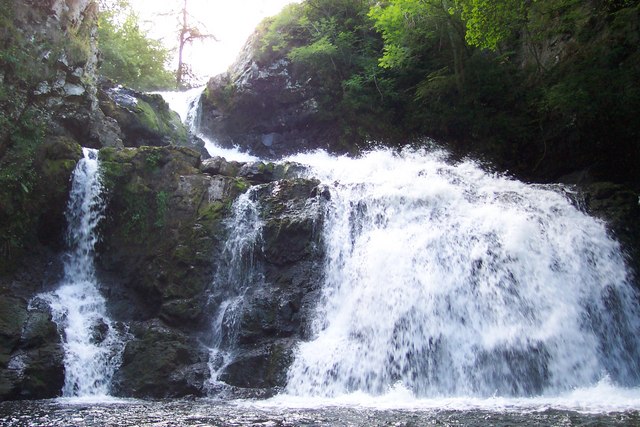
One of the main attractions of Bridgend of Lintrathen is the Lintrathen Reservoir, which covers an area of approximately 350 acres. The reservoir is popular among outdoor enthusiasts, offering opportunities for fishing, boating, and walking along the scenic shoreline. It is also a haven for birdwatchers, as it attracts a variety of bird species throughout the year.

The village is well-connected to the surrounding areas, with the town of Kirriemuir located just a short drive away. Kirriemuir offers a range of amenities including shops, schools, and leisure facilities, providing residents of Bridgend of Lintrathen with easy access to essential services.

In conclusion, Bridgend of Lintrathen is a charming village situated in the beautiful Angus countryside. With its peaceful atmosphere, stunning reservoir, and friendly community, it is a desirable location for those seeking a tranquil rural lifestyle.

If you have any feedback on the listing, please let us know in the comments section below.

Bridgend of Lintrathen Images

Images are sourced within 2km of 56.677345/-3.171651 or Grid Reference NO2854. Thanks to Geograph Open Source API. All images are credited.

Sand and mud flats, Loch of Lintrathen The northernmost corner of the loch where low water levels expose areas of sand and mud.
Sand and mud flats, Loch of Lintrathen
The northernmost corner of the loch where low water levels expose areas of sand and mud.
Melgam Water enters the Loch of Lintrathen The OS maps shows much of this area in blue, but with water levels low in the loch there is much sand and mud exposed which has become green with vegetation.
Melgam Water enters the Loch of Lintrathen
The OS maps shows much of this area in blue, but with water levels low in the loch there is much sand and mud exposed which has become green with vegetation.
Telephone box at Bridgend of Lintrathen The few buildings at the village of Bridgend of Lintrathen lie immediately below the dam of the Loch of Lintrathen; it's hidden from view in the image by trees. The telephone box is still standing, if leaning; it's not known if there's a functioning telephone inside.
Until recently, close beside the box stood an old, protected road sign; it was demolished by a falling tree during one of the storms of winter 2021-2022. A photograph of it can be seen... <a title="https://www.geograph.org.uk/photo/6043246" href="https://www.geograph.org.uk/photo/6043246">Link</a> .
Telephone box at Bridgend of Lintrathen
The few buildings at the village of Bridgend of Lintrathen lie immediately below the dam of the Loch of Lintrathen; it's hidden from view in the image by trees. The telephone box is still standing, if leaning; it's not known if there's a functioning telephone inside. Until recently, close beside the box stood an old, protected road sign; it was demolished by a falling tree during one of the storms of winter 2021-2022. A photograph of it can be seen... Link .
Loch of Lintrathen It is always surprisingly difficult to access the shore of Loch of Lintrathen. This stretch here is accessed by parking on a small space on the west side, and then ambling through a hole in the hedge down a narrow path to the shore.
Loch of Lintrathen
It is always surprisingly difficult to access the shore of Loch of Lintrathen. This stretch here is accessed by parking on a small space on the west side, and then ambling through a hole in the hedge down a narrow path to the shore.
Field above Loch of Lintrathen A mapped clump of trees.
Field above Loch of Lintrathen
A mapped clump of trees.
B951 A bridge over the Inzion Burn.
B951
A bridge over the Inzion Burn.
North of Loch of Lintrathen Cattle were grazing a set of fields with the interconnecting gates left open.  The woodlands are by the Inzeon Burn.
North of Loch of Lintrathen
Cattle were grazing a set of fields with the interconnecting gates left open. The woodlands are by the Inzeon Burn.
North of Loch of Lintrathen Cattle were grazing these fields.
North of Loch of Lintrathen
Cattle were grazing these fields.
North of Loch of Lintrathen Fields at the foot of Brankam Hill.
North of Loch of Lintrathen
Fields at the foot of Brankam Hill.
Brankam Hill View from the road.
Brankam Hill
View from the road.
Loch of Lintrathen The loch is well screened by trees, here there is a glimpse from above the B951.
Loch of Lintrathen
The loch is well screened by trees, here there is a glimpse from above the B951.
Barley beneath Brankam Hill
Gravel pit Sandy deposits have been quarried near Loch of Lintrathen.
Gravel pit
Sandy deposits have been quarried near Loch of Lintrathen.
Isla Primary School At Lintrathen.
<span class="nowrap"><a title="http://www.angus.gov.uk/directory_record/461/isla_primary_school" rel="nofollow ugc noopener" href="http://www.angus.gov.uk/directory_record/461/isla_primary_school">Link</a><img style="margin-left:2px;" alt="External link" title="External link - shift click to open in new window" src="https://s1.geograph.org.uk/img/external.png" width="10" height="10"/></span>
Isla Primary School
At Lintrathen. LinkExternal link
Arable field on Gallow Knowe Loch of Lintrathen reservoir in the background.
Arable field on Gallow Knowe
Loch of Lintrathen reservoir in the background.
Crossroads near Loch of Lintrathen B951 junction, right for Balintore and left for Formal via the west shore of the loch - a reservoir of potable water for Dundee. [Lintrathen ~ High water/fast-flowing water]
Crossroads near Loch of Lintrathen
B951 junction, right for Balintore and left for Formal via the west shore of the loch - a reservoir of potable water for Dundee. [Lintrathen ~ High water/fast-flowing water]
Entrance to Lintrathen sawmill Off B951.
Entrance to Lintrathen sawmill
Off B951.
The Egg Box Eggs for sale at the road entrance to Cairnhall. £2.50 a dozen with an honesty box inside. No money nor eggs were found inside.
The Egg Box
Eggs for sale at the road entrance to Cairnhall. £2.50 a dozen with an honesty box inside. No money nor eggs were found inside.
Show me another place!

Bridgend of Lintrathen is located at Grid Ref: NO2854 (Lat: 56.677345, Lng: -3.171651)

Unitary Authority: Angus

Police Authority: Tayside

What 3 Words

///crops.lends.frames. Near Alyth, Perth & Kinross

Related Wikis

Bridgend of Lintrathen

Bridgend of Lintrathen is a village in Angus, Scotland. It is situated on the southern shore of Loch of Lintrathen, six miles west of Kirriemuir. ��2...

Loch of Lintrathen

Loch of Lintrathen is a man-made loch occupying a glacial basin at the southern end of Glen Isla, approximately 13 kilometres (8.1 mi) west of town of...

Airlie Castle

Airlie Castle is a mansion house in the parish of Airlie, Angus, near the junction of the Isla and Melgund rivers, 9 kilometres west of Kirriemuir, Angus...

Bridge of Craigisla

Bridge of Craigisla is a hamlet in Angus, Scotland. The bridge crosses the River Isla. This settlement lies along the B954 road. == References ==

Airlie Parish Kirk

Airlie Parish Kirk is a church in Airlie, Angus. It was completed in 1783 and dedicated to St. Meddan. The interior was renovated in 1893. The church contains...

Airlie, Angus

Airlie (Scottish Gaelic: Iarlaidh) is a civil parish in the Scottish council area of Angus. It is the seat of the Earl of Airlie, and the location of...

Balintore, Angus

Balintore (Scottish Gaelic: Baile an Todhair) is a village in Angus, Scotland. It lies in Glen Isla, four miles north of the Loch of Lintrathen and seven...

Balintore Castle

Balintore Castle is a Victorian Category A listed building in Scotland. The castle occupies an elevated site in moorland above Balintore village, a few...

Nearby Amenities

Located within 500m of 56.677345,-3.171651
Bridge Cottage
Naptan AtcoCode: 6490IM053
Naptan Bearing: NE
Naptan BusStopType: CUS
Naptan CommonName: Bridge Cottage
Naptan Indicator: opp
Naptan Landmark: War Memorial
Naptan NaptanCode: 26424923
Naptan Street: Unclassified Road
Naptan Verified: no
Source: naptan_import
Lat/Long: 56.6773003/-3.1717189
Bus Stop
Bridge Cottage
Bus: yes
Local Ref: AT
Naptan AtcoCode: 6490IM397
Naptan Bearing: S
Naptan BusStopType: CUS
Naptan CommonName: Bridge Cottage
Naptan Indicator: at
Naptan Landmark: War Memorial
Naptan NaptanCode: 26426879
Naptan Verified: no
Public Transport: platform
Source: naptan_import
Lat/Long: 56.6770864/-3.1715084
Cafe
Wee Bear Café
Cuisine: coffee_shop;cake;local;sandwich;tea
Diet Vegan: yes
Internet Access: wlan
Lat/Long: 56.6768131/-3.1721048
Bridgend of Lintrathen
Place: village
Wikidata: Q4966546
Wikipedia: en:Bridgend of Lintrathen
Lat/Long: 56.6772434/-3.1717281
Bridgend of Lintrathen
Traffic Sign: city_limit
Traffic Sign Direction: forward
Lat/Long: 56.6762629/-3.1710303
Lochside Lodge
Tourism: hotel
Lat/Long: 56.6769223/-3.172076
Information: board
Tourism: information
Lat/Long: 56.6772376/-3.1718855
Historic: memorial
Memorial: war_memorial
Lat/Long: 56.6772627/-3.1720277
Telephone
Booth: K6
Covered: booth
Man Made: telephone_box
Lat/Long: 56.6773172/-3.1715368
Information: guidepost
Tourism: information
Lat/Long: 56.6772907/-3.1716656
Bridgend of Lintrathen
Traffic Sign: city_limit
Traffic Sign Direction: forward
Lat/Long: 56.6761297/-3.174848
Bridgend of Lintrathen
Traffic Sign: city_limit
Traffic Sign Direction: forward
Lat/Long: 56.6782594/-3.1673906
Power: pole
Lat/Long: 56.6737499/-3.1679883
Power: pole
Lat/Long: 56.6745633/-3.1674971
Power: pole
Lat/Long: 56.6754502/-3.1669637
Power: pole
Lat/Long: 56.6758014/-3.1664937
Power: pole
Lat/Long: 56.6764017/-3.1656688
Power: pole
Lat/Long: 56.6770021/-3.1648815
Power: pole
Lat/Long: 56.6778076/-3.1637888
Power: pole
Lat/Long: 56.6778937/-3.1697688
Power: pole
Lat/Long: 56.6780374/-3.1666211
Power: pole
Lat/Long: 56.6779699/-3.1683451
Power: pole
Lat/Long: 56.6780061/-3.1675491
Power: pole
Lat/Long: 56.6779337/-3.1653316
Post Box
Post Box Mounting: pier
Post Box Type: lamp
Ref: DD8 71
Royal Cypher: scottish_crown
Lat/Long: 56.6773378/-3.1715395
The data included in this document is from www.openstreetmap.org. The data is made available under ODbL.

Have you been to Bridgend of Lintrathen?

Leave your review of Bridgend of Lintrathen below (or comments, questions and feedback).