Bridge Street

Settlement in Suffolk Babergh

England

Bridge Street

A134 looking north A route from Colchester to King's Lynn, next major place, Bury St Edmunds. A 30 limit applies here for Alpheton.
A134 looking north Credit: Robin Webster

Bridge Street is a historic thoroughfare located in the charming town of Suffolk, England. Situated in the heart of the town, it spans approximately 500 meters and is lined with a variety of architectural treasures that showcase the town's rich heritage.

The street derives its name from the bridge that crosses over the River Orwell, connecting the western and eastern parts of the town. This picturesque bridge serves as a prominent landmark and offers breathtaking views of the surrounding countryside.

Bridge Street is characterized by its well-preserved medieval buildings, which reflect the town's prosperous history. The street is home to a diverse range of establishments, including quaint shops, traditional pubs, and cozy cafes. Visitors can explore the unique boutiques that dot the street, offering a delightful selection of antiques, handmade crafts, and locally produced goods.

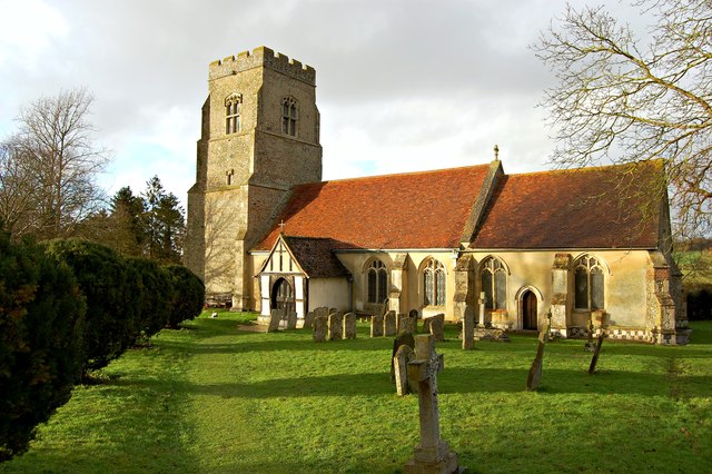
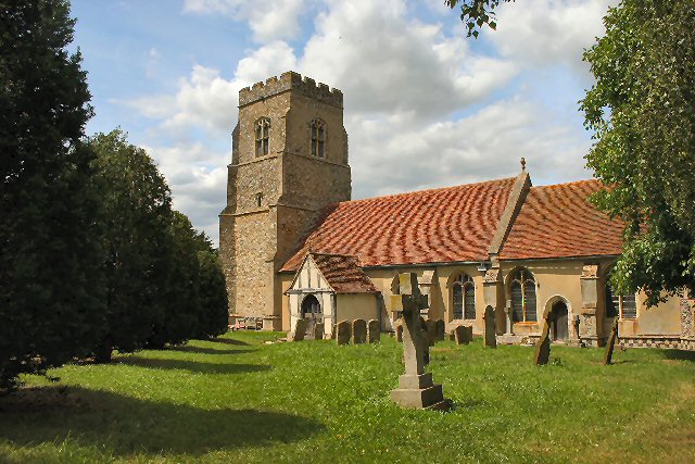
One of the notable landmarks on Bridge Street is St. Mary's Church, a magnificent structure dating back to the 15th century. Its towering spire can be seen from various points along the street, adding to the area's charm.

The street also hosts a vibrant market every Wednesday, where locals and tourists alike can browse through a variety of stalls selling fresh produce, artisanal products, and unique souvenirs.

Bridge Street is not only a place of historical significance but also a bustling hub of activity and a testament to the town's vibrant community. Whether strolling along the riverbanks, exploring the shops, or simply enjoying the ambiance, visitors to Bridge Street are sure to be captivated by its timeless allure.

If you have any feedback on the listing, please let us know in the comments section below.

Bridge Street Images

Images are sourced within 2km of 52.108365/0.741754 or Grid Reference TL8749. Thanks to Geograph Open Source API. All images are credited.

A134 looking north A route from Colchester to King's Lynn, next major place, Bury St Edmunds. A 30 limit applies here for Alpheton.
A134 looking north
A route from Colchester to King's Lynn, next major place, Bury St Edmunds. A 30 limit applies here for Alpheton.
Old Road Part of the old A.134 at Alpheton, Suffolk.
Old Road
Part of the old A.134 at Alpheton, Suffolk.
Tye Farm Tye Farm at Alpheton, Suffolk.
Tye Farm
Tye Farm at Alpheton, Suffolk.
Bus Shelter Bus shelter, post box village sign at Alpheton, Suffolk
Bus Shelter
Bus shelter, post box village sign at Alpheton, Suffolk
Ss. Peter and Paul Alpheton parish church
Ss. Peter and Paul
Alpheton parish church
Tye Green, Alpheton At the junction with Church Lane
Tye Green, Alpheton
At the junction with Church Lane
Tye Green Postbox On Tye Green at the junction with Church Lane
Postbox No.CO10 1040
Tye Green Postbox
On Tye Green at the junction with Church Lane Postbox No.CO10 1040
Tye Green Postbox On Tye Green at the junction with Church Lane
Postbox No.CO10 1040
Tye Green Postbox
On Tye Green at the junction with Church Lane Postbox No.CO10 1040
Tye Green Postbox On Tye Green at the junction with Church Lane
Postbox No.CO10 1040
(Close up)
Tye Green Postbox
On Tye Green at the junction with Church Lane Postbox No.CO10 1040 (Close up)
Alpheton Garage Ltd On Tye Green at the junction with Church Lane
<span class="nowrap"><a title="http://www.alphetongarage.com/" rel="nofollow ugc noopener" href="http://www.alphetongarage.com/">Link</a><img style="margin-left:2px;" alt="External link" title="External link - shift click to open in new window" src="https://s1.geograph.org.uk/img/external.png" width="10" height="10"/></span>
Alpheton Garage Ltd
On Tye Green at the junction with Church Lane LinkExternal link
Alpheton Village sign On Tye Green at the junction with Church Lane
Alpheton Village sign
On Tye Green at the junction with Church Lane
Alpheton Village sign On Tye Green at the junction with Church Lane
(Close up)
Alpheton Village sign
On Tye Green at the junction with Church Lane (Close up)
Alpheton Church sign On Tye Green at the junction with Church Lane
Alpheton Church sign
On Tye Green at the junction with Church Lane
Tye Green sign On Tye Green at the junction with Church Lane
Tye Green sign
On Tye Green at the junction with Church Lane
Bus Shelter on Tye Green At the junction with Church Lane
Bus Shelter on Tye Green
At the junction with Church Lane
Church Lane, Alpheton At the junction with Tye Green
Church Lane, Alpheton
At the junction with Tye Green
Church Lane sign On Church Lane at the junction with Tye Green
Church Lane sign
On Church Lane at the junction with Tye Green
Alpheton Church & Alpheton Hall Off Church Lane
<span class="nowrap"><a title="http://www.alpheton-hall-barns.co.uk/" rel="nofollow ugc noopener" href="http://www.alpheton-hall-barns.co.uk/">Link</a><img style="margin-left:2px;" alt="External link" title="External link - shift click to open in new window" src="https://s1.geograph.org.uk/img/external.png" width="10" height="10"/></span>
Alpheton Church & Alpheton Hall
Off Church Lane LinkExternal link
Show me another place!

Bridge Street is located at Grid Ref: TL8749 (Lat: 52.108365, Lng: 0.741754)

Administrative County: Suffolk

District: Babergh

Police Authority: Suffolk

What 3 Words

///remainder.stocky.limo. Near Lavenham, Suffolk

Nearby Locations

Bridge Street

Related Wikis

Lineage Wood & Railway Track, Long Melford

Lineage Wood & Railway Track, Long Melford is a 78.7-hectare (194-acre) biological Site of Special Scientific Interest north-east of Long Melford in Suffolk...
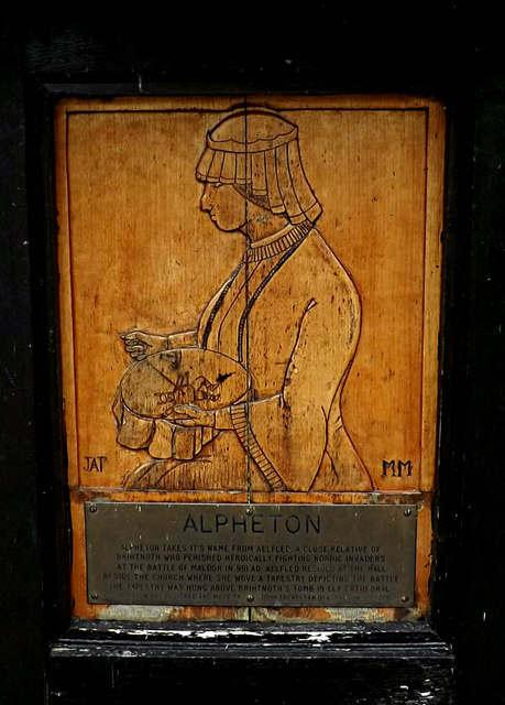
Alpheton

Alpheton is a village and civil parish in the Babergh district of Suffolk, England. Located on the A134 road about six miles north of Sudbury, in 2005...

Kentwell Woods

Kentwell Woods is a 77.6-hectare (192-acre) biological Site of Special Scientific Interest in fifteen woods in fourteen separate blocks east and north...

The Railway Walks

The Railway Walks is a 25.3 hectare Local Nature Reserve which runs along parts of a former railway line between Sudbury and Lavenham in Suffolk. It is...

Nearby Amenities

Located within 500m of 52.108365,0.741754
Walker's Hub
Defibrillator
Access: yes
Booth: K6
Covered: booth
Defibrillator Location: inside old red phone box, Bridge Street
Disused Amenity: telephone
Emergency: defibrillator
Listed Status: Grade II
Man Made: telephone_box
Ref GB The Circuit: 879CA424-1252-4859-827E-AE6F00E676EB
Lat/Long: 52.1085077/0.7408534
Post Box
Operator: Royal Mail
Post Box Type: lamp
Royal Cypher: EIIR
Royal Cypher Wikidata: Q33102113
Lat/Long: 52.108552/0.7409613
Bus Stop
Rose and Crown
Naptan AtcoCode: 390010201
Naptan Bearing: N
Naptan CommonName: Rose and Crown
Naptan Indicator: adj
Naptan Landmark: Rose and Crown
Naptan NaptanCode: sufadpap
Naptan Street: A134
Naptan Verified: no
Source: naptan_import
Lat/Long: 52.1088083/0.7416824
Bus Stop
Rose and Crown
Naptan AtcoCode: 390010202
Naptan Bearing: SW
Naptan BusStopType: CUS
Naptan CommonName: Rose and Crown
Naptan Indicator: opp
Naptan Landmark: Rose and Crown
Naptan NaptanCode: sufadpat
Naptan Street: A134
Naptan Verified: no
Source: naptan_import
Lat/Long: 52.1087836/0.741973
Barrier: stile
Lat/Long: 52.1092857/0.7406805
Barrier: stile
Source: Survey
Lat/Long: 52.1101091/0.7404174
Barrier: stile
Lat/Long: 52.1089151/0.7415613
Milestone
Lat/Long: 52.1063455/0.738337
Bridge Street
Place: hamlet
Wikidata: Q2623627
Lat/Long: 52.1082807/0.7422522
The data included in this document is from www.openstreetmap.org. The data is made available under ODbL.

Have you been to Bridge Street?

Leave your review of Bridge Street below (or comments, questions and feedback).