Llanddewibrefi

Community in Cardiganshire

Wales

Llanddewibrefi

Forestry and moorland east of Llanddewi-Brefi, Ceredigion Looking east towards Esgair Llethr (471 metres, 1545 feet) from the mountain road near Blaendoethie.
There are many images available of beautiful Elenydd landscapes with blue skies and fluffy cumulus clouds drifting. This one sets the record straight, and represents the Elenydd moorlands in their more usual guise. ;-)

It is often like this up here when the sun is shining in the Teifi valley at Llanddewi-Brefi or Tregaron just five or six miles away.
Forestry and moorland east of Llanddewi-Brefi, Ceredigion Credit: Roger D Kidd

The requested URL returned error: 429 Too Many Requests

If you have any feedback on the listing, please let us know in the comments section below.

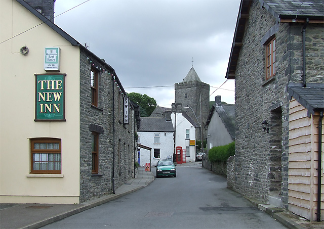
Llanddewibrefi Images

Images are sourced within 2km of 52.162465/-3.878612 or Grid Reference SN7153. Thanks to Geograph Open Source API. All images are credited.

Forestry and moorland east of Llanddewi-Brefi, Ceredigion Looking east towards Esgair Llethr (471 metres, 1545 feet) from the mountain road near Blaendoethie.
There are many images available of beautiful Elenydd landscapes with blue skies and fluffy cumulus clouds drifting. This one sets the record straight, and represents the Elenydd moorlands in their more usual guise. ;-)

It is often like this up here when the sun is shining in the Teifi valley at Llanddewi-Brefi or Tregaron just five or six miles away.
Forestry and moorland east of Llanddewi-Brefi, Ceredigion
Looking east towards Esgair Llethr (471 metres, 1545 feet) from the mountain road near Blaendoethie. There are many images available of beautiful Elenydd landscapes with blue skies and fluffy cumulus clouds drifting. This one sets the record straight, and represents the Elenydd moorlands in their more usual guise. ;-) It is often like this up here when the sun is shining in the Teifi valley at Llanddewi-Brefi or Tregaron just five or six miles away.
Trac yn gadael yr heol / Track exiting the road Trac coedwigaeth ar y chwith yn gadael heol fach wledig. Sylwer hefyd ar y arwydd i Hostel Tyn y Cornel.

A forestry track on the left exits a minor rural road. Note the sign for Tyn y Cornel Hostel (trans. corner homestead).
Trac yn gadael yr heol / Track exiting the road
Trac coedwigaeth ar y chwith yn gadael heol fach wledig. Sylwer hefyd ar y arwydd i Hostel Tyn y Cornel. A forestry track on the left exits a minor rural road. Note the sign for Tyn y Cornel Hostel (trans. corner homestead).
Trac yn gadael yr heol / Track exiting the road Trac coedwigaeth ar y chwith yn gadael heol fach wledig.

Forestry track on the left exits a minor rural road.
Trac yn gadael yr heol / Track exiting the road
Trac coedwigaeth ar y chwith yn gadael heol fach wledig. Forestry track on the left exits a minor rural road.
Trac yn gadael yr heol / Track exiting the road Trac yn gadael heol fach wledig ger Waun Bryn Owen.

Track exits the road near Waun Bryn Owen (trans. the wet land of Owen's hill).
Trac yn gadael yr heol / Track exiting the road
Trac yn gadael heol fach wledig ger Waun Bryn Owen. Track exits the road near Waun Bryn Owen (trans. the wet land of Owen's hill).
Trac fynedfa yn gadael heol / An access road exits the road Heol fynedfa i Fryn Garegog yn gadael ffordd fach wledig.

An access road to Bryn Garegog (trans. stony hill) exits a minor rural road.
Trac fynedfa yn gadael heol / An access road exits the road
Heol fynedfa i Fryn Garegog yn gadael ffordd fach wledig. An access road to Bryn Garegog (trans. stony hill) exits a minor rural road.
Ffordd fynedfa i goedwigaeth / Access road to forestry Ffordd fynedfa i blanhigfa gonifferaidd ac anhedd-dy.

An access road to a conifer plantation and a property.
Ffordd fynedfa i goedwigaeth / Access road to forestry
Ffordd fynedfa i blanhigfa gonifferaidd ac anhedd-dy. An access road to a conifer plantation and a property.
Gweddillion Esgair Maen / Remains of Esgair Maen Gweddillion Ffarm Esgair Maen. Byddai'r pileri cerrig yn y blaendir wedi cynnal yr hen ysgubor.  Yn ystod y rhan fwyaf o'r 1800au bu'n gartref i David Ajax a'i deulu. Heddiw, mae'r ty ffarm wedi ei hamgylchynu gan blanhigfa gonifferaidd. 

The remains of Esgair Maen (trans. stone ridge) and for most of the 1800s it was home to David Ajax and his family.  The stone pillars in the foreground would have supported the former hay loft. The property today is surrounded by a conifer plantation.
Gweddillion Esgair Maen / Remains of Esgair Maen
Gweddillion Ffarm Esgair Maen. Byddai'r pileri cerrig yn y blaendir wedi cynnal yr hen ysgubor. Yn ystod y rhan fwyaf o'r 1800au bu'n gartref i David Ajax a'i deulu. Heddiw, mae'r ty ffarm wedi ei hamgylchynu gan blanhigfa gonifferaidd. The remains of Esgair Maen (trans. stone ridge) and for most of the 1800s it was home to David Ajax and his family. The stone pillars in the foreground would have supported the former hay loft. The property today is surrounded by a conifer plantation.
Gweddillion Ffarm Egair Maen / Remains of Egair Maen Farm Gweddillion Ffarm Esgair Maen ac yn ystod y rhan fwyaf o'r 1800au bu'n gartref i David Ajax a'i deulu. Mae'r ffarm bellach wedi ei hamgylchynu gan blanhigfa gonifferaidd.  

The remains of Esgair Maen (trans. stone ridge) and for most of the 1800s it was home to David Ajax and his family.  The property today is surrounded by a conifer plantation.
Gweddillion Ffarm Egair Maen / Remains of Egair Maen Farm
Gweddillion Ffarm Esgair Maen ac yn ystod y rhan fwyaf o'r 1800au bu'n gartref i David Ajax a'i deulu. Mae'r ffarm bellach wedi ei hamgylchynu gan blanhigfa gonifferaidd. The remains of Esgair Maen (trans. stone ridge) and for most of the 1800s it was home to David Ajax and his family. The property today is surrounded by a conifer plantation.
Ffarm Esgair Maen / Esgair Maen Farm Gweddillion Ffarm Esgair Maen ac yn ystod y rhan fwyaf o'r 1800au bu'n gartref i David Ajax a'i deulu. Mae'r ffarm bellach wedi ei hamgylchynu gan blanhigfa gonifferaidd.  

The remains of Esgair Maen (trans. stone ridge) and for most of the 1800s it was home to David Ajax and his family.  The property today is surrounded by a conifer plantation.
Ffarm Esgair Maen / Esgair Maen Farm
Gweddillion Ffarm Esgair Maen ac yn ystod y rhan fwyaf o'r 1800au bu'n gartref i David Ajax a'i deulu. Mae'r ffarm bellach wedi ei hamgylchynu gan blanhigfa gonifferaidd. The remains of Esgair Maen (trans. stone ridge) and for most of the 1800s it was home to David Ajax and his family. The property today is surrounded by a conifer plantation.
Ger Esgair Maen / Near Esgair Maen Gât yn rhoi mynediad i blanhigfa gonifferaidd ger Esgair Maen.

A gate gives access to a conifer plantation near Esgair Maen (trans. stone ridge).
Ger Esgair Maen / Near Esgair Maen
Gât yn rhoi mynediad i blanhigfa gonifferaidd ger Esgair Maen. A gate gives access to a conifer plantation near Esgair Maen (trans. stone ridge).
Planhigfa Esgair Maen / Esgair Maen plantation Planhigfa gonifferaidd yn Esgair Main. Y tyle yn y pellter yw Llethr Erwast.

A conifer plantation at Esgair Maen (trans. stone ridge). The hill in the distance is Llethr Erwast.
Planhigfa Esgair Maen / Esgair Maen plantation
Planhigfa gonifferaidd yn Esgair Main. Y tyle yn y pellter yw Llethr Erwast. A conifer plantation at Esgair Maen (trans. stone ridge). The hill in the distance is Llethr Erwast.
Toriad tân mewn planhigfa / Fire break in a plantation Toriad tân o fewn planhigfa gonifferaidd mewn lleoliad a elwir Esgair Maen.

A fire break within a conifer plantation at a location known as Esgair Maen (trans. stone ridge).
Toriad tân mewn planhigfa / Fire break in a plantation
Toriad tân o fewn planhigfa gonifferaidd mewn lleoliad a elwir Esgair Maen. A fire break within a conifer plantation at a location known as Esgair Maen (trans. stone ridge).
Drainllwyn-du Edrych draw tuag at anhedd-dy o'r enw Drainllwyn-du. 

Looking towards  a property known as Drainllwyn-du (trans. black grove of hawthorn trees).
Drainllwyn-du
Edrych draw tuag at anhedd-dy o'r enw Drainllwyn-du. Looking towards a property known as Drainllwyn-du (trans. black grove of hawthorn trees).
Trac coedwigaeth / Forestry track Trac coedwigaeth ger Bronbyrfe. Y gofod  ar y chwith yw'r man lle  mae'r coed eisioes wedi cael eu cynhaeafu a'u hailblannu.

Forestry track near Bronbyrfe.  The space on the left is where trees have already been harvested and replanted.
Trac coedwigaeth / Forestry track
Trac coedwigaeth ger Bronbyrfe. Y gofod ar y chwith yw'r man lle mae'r coed eisioes wedi cael eu cynhaeafu a'u hailblannu. Forestry track near Bronbyrfe. The space on the left is where trees have already been harvested and replanted.
Garn-lwyd Heol fach wledig yn mynd heibio i anhedd-dy o'r enw Garn-lwyd.

A minor rural road passes a property known as Garn-lwyd (trans. grey cairn /rock).
Garn-lwyd
Heol fach wledig yn mynd heibio i anhedd-dy o'r enw Garn-lwyd. A minor rural road passes a property known as Garn-lwyd (trans. grey cairn /rock).
Trac coedigaeth / Forestry track Trac coedwigaeth ger Bryn Moel. Mae'n amlwg bod llawer o waith wedi mynd  i mewn i greu'r trac hwn.

A forestry track near Bryn Moel (trans. bare hilltop).  It's clear that a lot of work went in to create this track.
Trac coedigaeth / Forestry track
Trac coedwigaeth ger Bryn Moel. Mae'n amlwg bod llawer o waith wedi mynd i mewn i greu'r trac hwn. A forestry track near Bryn Moel (trans. bare hilltop). It's clear that a lot of work went in to create this track.
Cynaeafu coed / Harvesting trees Peirianwaith wrthi yn y pellter yn cynaeafu coed ger Bryn Moel.

Machinery in the distance harvesting trees near Bryn Moel (trans. bare hilltop).
Cynaeafu coed / Harvesting trees
Peirianwaith wrthi yn y pellter yn cynaeafu coed ger Bryn Moel. Machinery in the distance harvesting trees near Bryn Moel (trans. bare hilltop).
Cleared forest near the Afon Pysgotwr Fawr in Ceredigion This is at the head of the river, which is off to the right. The former drover's road to Abergwesyn via Soar-y-Mynydd forks to the left.
Cleared forest near the Afon Pysgotwr Fawr in Ceredigion
This is at the head of the river, which is off to the right. The former drover's road to Abergwesyn via Soar-y-Mynydd forks to the left.
Show me another place!

Llanddewibrefi is located at Grid Ref: SN7153 (Lat: 52.162465, Lng: -3.878612)

Unitary Authority: Ceredigion

Police Authority: Dyfed-Powys

Also known as: Llanddewi Brefi

What 3 Words

///passwords.plans.toolbar. Near Tregaron, Ceredigion

Related Wikis

Pentre-rhew

Pentre-rhew is a hamlet in the community of Llanddewibrefi, Ceredigion, Wales, which is 58.3 miles (93.9 km) from Cardiff and 169.6 miles (272.9 km) from...

St David's Church, Llanddewi Brefi

St David's Church is a Grade II* listed medieval church in the Welsh village of Llanddewi Brefi, 3 miles south of Tregaron in the county of Ceredigion...

Llanddewi Brefi

Llanddewi Brefi (Welsh pronunciation: [ɬanˈðɛwi ˈbrɛvi]) is a village, parish and community of approximately 500 people in Ceredigion, Wales. The village...

Camddwr

For the tributary of the River Wye, see Camddwr, Wye and for the tributary of the River Teifi, see Camddwr, Teifi.The Camddwr is a significant right-bank...

Nearby Amenities

Located within 500m of 52.162465,-3.878612
Barrier: cattle_grid
Lat/Long: 52.1602938/-3.8742873
The data included in this document is from www.openstreetmap.org. The data is made available under ODbL.

Have you been to Llanddewibrefi?

Leave your review of Llanddewibrefi below (or comments, questions and feedback).