Yaxley

Settlement in Suffolk Mid Suffolk

England

Yaxley

Thornham Parva Church
Thornham Parva Church Credit: Dave Thompson

Yaxley is a small village located in the county of Suffolk, England. Situated about eight miles northeast of the town of Eye, Yaxley is surrounded by picturesque countryside, offering residents and visitors a tranquil and rural setting. The village is part of the Mid Suffolk district and falls under the civil parish of Stradbroke.

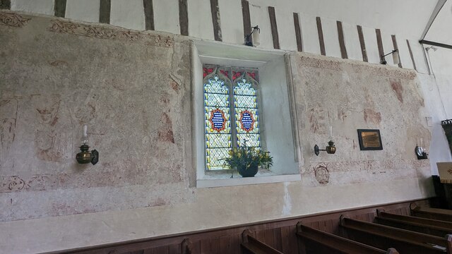
Yaxley, with a population of around 500 people, has a rich history dating back many centuries. It is mentioned in the Domesday Book of 1086, where it is referred to as "Giaxlea." Evidence of its past can still be seen today, with several historic buildings and structures dotting the village. One notable landmark is St. Mary's Church, a beautiful medieval church that has stood since the 14th century and attracts visitors interested in its architectural and historical significance.

The village also boasts a vibrant community spirit, with various local events and activities taking place throughout the year. Yaxley is home to a primary school, providing education for children in the area. Additionally, the village has a pub, The Cherry Tree Inn, which serves as a hub for social gatherings and a place to enjoy traditional pub fare.

Yaxley's rural surroundings offer opportunities for outdoor pursuits, such as walking, cycling, and exploring the nearby countryside. The village's proximity to larger towns, such as Eye and Diss, provides residents with access to a wider range of amenities, including shops, supermarkets, and healthcare facilities.

Overall, Yaxley offers a peaceful and close-knit community, steeped in history and surrounded by the natural beauty of the Suffolk countryside.

If you have any feedback on the listing, please let us know in the comments section below.

Yaxley Images

Images are sourced within 2km of 52.321583/1.1094146 or Grid Reference TM1273. Thanks to Geograph Open Source API. All images are credited.

Thornham Parva Church
Approaching Mellis by field
Towards Kiln Farm - Mellis
On Judas Lane
On Judas Lane
On Green Lane
On Green Lane
Chandos Farm, Thornham Parva
A140 north approaching B1117 junction
A140 north approaching new island at Yaxley
Sports centre, Hartismere Sixth Form College
Castleton Way heading west from Eye
The Bull Auberge <span class="nowrap"><a title="https://historicengland.org.uk/listing/the-list/list-entry/1181752?section=official-list-entry" rel="nofollow ugc noopener" href="https://historicengland.org.uk/listing/the-list/list-entry/1181752?section=official-list-entry">Link</a><img style="margin-left:2px;" alt="External link" title="External link - shift click to open in new window" src="https://s1.geograph.org.uk/img/external.png" width="10" height="10"/></span>
The Bull Auberge
Tandem House
Tandem House
212 and 213 Bull Road, Thornham Parva <span class="nowrap"><a title="https://historicengland.org.uk/listing/the-list/list-entry/1181199" rel="nofollow ugc noopener" href="https://historicengland.org.uk/listing/the-list/list-entry/1181199">Link</a><img style="margin-left:2px;" alt="External link" title="External link - shift click to open in new window" src="https://s1.geograph.org.uk/img/external.png" width="10" height="10"/></span>
212 and 213 Bull Road, Thornham Parva
Church of St Mary, Thornham Parva <span class="nowrap"><a title="https://historicengland.org.uk/listing/the-list/list-entry/1285113?section=official-list-entry" rel="nofollow ugc noopener" href="https://historicengland.org.uk/listing/the-list/list-entry/1285113?section=official-list-entry">Link</a><img style="margin-left:2px;" alt="External link" title="External link - shift click to open in new window" src="https://s1.geograph.org.uk/img/external.png" width="10" height="10"/></span>
Church of St Mary, Thornham Parva
Medieval Wall Painting in Church of St Mary, Thornham Parva <span class="nowrap"><a title="https://historicengland.org.uk/listing/the-list/list-entry/1285113?section=official-list-entry" rel="nofollow ugc noopener" href="https://historicengland.org.uk/listing/the-list/list-entry/1285113?section=official-list-entry">Link</a><img style="margin-left:2px;" alt="External link" title="External link - shift click to open in new window" src="https://s1.geograph.org.uk/img/external.png" width="10" height="10"/></span>
Medieval Wall Painting in Church of St Mary, Thornham Parva
Font in Church of St Mary, Thornham Parva <span class="nowrap"><a title="https://historicengland.org.uk/listing/the-list/list-entry/1285113?section=official-list-entry" rel="nofollow ugc noopener" href="https://historicengland.org.uk/listing/the-list/list-entry/1285113?section=official-list-entry">Link</a><img style="margin-left:2px;" alt="External link" title="External link - shift click to open in new window" src="https://s1.geograph.org.uk/img/external.png" width="10" height="10"/></span>
Font in Church of St Mary, Thornham Parva
Show me another place!

Yaxley is located at Grid Ref: TM1273 (Lat: 52.321583, Lng: 1.1094146)

Administrative County: Suffolk

District: Mid Suffolk

Police Authority: Suffolk

What 3 Words

///shadow.thrashed.print. Near Scole, Norfolk

Nearby Locations

Yaxley Beacon Hill

Related Wikis

Yaxley, Suffolk

Yaxley is a small village just west of Eye in Suffolk, England. The name means 'cuckoo-clearing'. == Church of St. Mary == Pevsner describes the north...

Yaxley Halt railway station

Yaxley Halt railway station was located in Yaxley, Suffolk. It was midway along a branch line from Mellis to the terminus at Eye which opened in 1867....

Pye Road

Pye Road is a Roman road running from the capital of the Iceni at Venta Icenorum (Caistor St Edmund near Norwich) to the original Roman provincial capital...

Major Farm Meadow

Major Farm Meadow is a 1.8-hectare (4.4-acre) biological Site of Special Scientific Interest south-west of Eye in Suffolk.This is one of the few surviving...

Nearby Amenities

Located within 500m of 52.321583,1.1094146
Yaxley
Created By: Potlatch 0.10b
Place: village
Wikidata: Q8050499
Lat/Long: 52.3232068/1.110045
Bus Stop
Kent Lodge
Naptan AtcoCode: 390040127
Naptan Bearing: W
Naptan BusStopType: CUS
Naptan CommonName: Kent Lodge
Naptan Indicator: opp
Naptan Landmark: Kent Lodge
Naptan NaptanCode: sufawawd
Naptan Street: Eye Road
Naptan Verified: no
Source: naptan_import
Lat/Long: 52.3249465/1.1124975
Bus Stop
Post Office
Naptan AtcoCode: 390040128
Naptan Bearing: N
Naptan CommonName: Post Office
Naptan Indicator: adj
Naptan Landmark: Post Office
Naptan NaptanCode: sufawawg
Naptan Street: Ipswich Road
Naptan Verified: no
Source: naptan_import
Lat/Long: 52.3249505/1.1116611
Bus Stop
Post Office
Naptan AtcoCode: 390040803
Naptan Bearing: S
Naptan BusStopType: CUS
Naptan CommonName: Post Office
Naptan Indicator: opp
Naptan Landmark: Post Office
Naptan NaptanCode: sufjgagw
Naptan Street: Ipswich Road
Naptan Verified: no
Source: naptan_import
Lat/Long: 52.3248663/1.1117873
Bus Stop
Kent Lodge
Naptan AtcoCode: 390040804
Naptan Bearing: E
Naptan BusStopType: CUS
Naptan CommonName: Kent Lodge
Naptan Indicator: adj
Naptan Landmark: Kent Lodge
Naptan NaptanCode: sufjgaja
Naptan Street: Eye Road
Naptan Verified: no
Source: naptan_import
Lat/Long: 52.3250332/1.112621
Yaxley
Historic Railway: halt
Railway: site
Wikidata: Q8050494
Wikipedia: en:Yaxley Halt railway station
Lat/Long: 52.3241639/1.1108613
War Memorial
Description: Tall stone cross on engraved pedestal and plinth, in corner of graveyard near gate.
Historic: memorial
Inscription: To the Glory of God and in Grateful Remembrance of Those Who Died for Their Country in the Great War 1914 - 1919 (8 mens names engraved) 1939 - 1945 (3 mens names engraved).
Wikidata: Q26677822
Lat/Long: 52.3224854/1.1106425
Barrier: stile
Bicycle: yes
Foot: yes
Material: wood
Stile: stepover
Lat/Long: 52.3202419/1.1072588
Barrier: stile
Bicycle: yes
Foot: yes
Material: wood
Stile: stepover
Lat/Long: 52.3210145/1.1064779
Give Way
Lat/Long: 52.3250894/1.1118458
Give Way
Lat/Long: 52.3257748/1.1118561
Power: pole
Lat/Long: 52.3243621/1.1145119
Power: pole
Lat/Long: 52.3238732/1.1153122
Power: pole
Lat/Long: 52.3235749/1.1159874
Location Transition: yes
Power: pole
Lat/Long: 52.3248399/1.1137873
Power: pole
Lat/Long: 52.3221978/1.1137283
Power: pole
Lat/Long: 52.3229863/1.114549
Post Office
Yaxley Mobile Post Office Service
Addr City: Eye
Addr Housename: The Village Hall Car Park
Addr Postcode: IP23 8BX
Addr Street: Old Ipswich Road
Addr Village: Yaxley
Brand: Post Office
Brand Wikidata: Q1783168
Contact Website: https://www.postoffice.co.uk/branch-finder/7371365/yaxley-mobile-service
Fixme: verify by survey
Opening Hours: Fr 09:00-10:00
Ref Pol Id: 148568
Source: pol_branch_list_2019-03
Lat/Long: 52.3226/1.1095
Barrier: stile
Foot: yes
Material: wood
Stile: stepover
Lat/Long: 52.3222048/1.1125977
Barrier: stile
Foot: yes
Material: wood
Stile: stepover
Lat/Long: 52.3214006/1.112874
Barrier: stile
Foot: yes
Material: wood
Stile: stepover
Lat/Long: 52.3196833/1.1131011
Grit Bin
Lat/Long: 52.3249917/1.1119366
Waste Basket
Waste: trash
Lat/Long: 52.325006/1.1116945
Board Type: notice
Information: board
Tourism: information
Lat/Long: 52.3250189/1.1116955
Bench
Backrest: yes
Material: wood
Lat/Long: 52.3250366/1.1116871
Waste Basket
Waste: trash
Lat/Long: 52.3248962/1.1128452
Recycling
Recycling Glass Bottles: yes
Recycling Paper: yes
Recycling Type: container
Lat/Long: 52.3248909/1.1128928
The data included in this document is from www.openstreetmap.org. The data is made available under ODbL.

Have you been to Yaxley?

Leave your review of Yaxley below (or comments, questions and feedback).