Bredon's Norton

Settlement in Worcestershire Wychavon

England

Bredon's Norton

The Pad, Kemerton A farm track from Kemerton up onto Bredon Hill. The parish of Kemerton stretched all the way from the Carrant Brook to the top of Bredon Hill.
The Pad, Kemerton Credit: David Hawgood

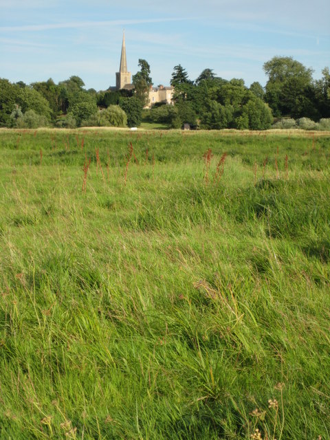
Bredon's Norton is a small village located in Worcestershire, England. Situated on the eastern side of the River Avon, it forms part of the larger Bredon's Norton civil parish. The village is surrounded by beautiful countryside, offering residents and visitors a peaceful and picturesque setting.

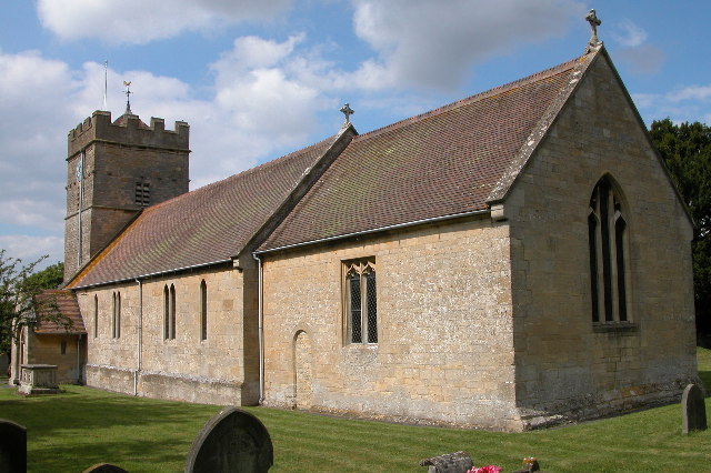
Despite its small size, Bredon's Norton has a rich history that dates back centuries. The village is home to St. Giles Church, a Grade II listed building that showcases stunning medieval architecture. This historic landmark provides a glimpse into the village's past and serves as a focal point for community gatherings and religious events.

The village itself consists of a mix of traditional stone cottages and more modern houses, providing a diverse range of housing options. It is primarily a residential area, with a close-knit community that fosters a friendly and welcoming atmosphere.

While Bredon's Norton may not have extensive amenities within its boundaries, it benefits from its proximity to nearby towns. The larger village of Bredon is just a short distance away, offering a wider range of shops, services, and recreational facilities. The surrounding countryside provides ample opportunities for outdoor activities such as walking, cycling, and horse riding.

Overall, Bredon's Norton is a charming village that offers a tranquil and idyllic lifestyle for its residents. With its historical significance, natural beauty, and close-knit community, it is a place that holds great appeal for those seeking a peaceful retreat in the heart of Worcestershire.

If you have any feedback on the listing, please let us know in the comments section below.

Bredon's Norton Images

Images are sourced within 2km of 52.049949/-2.098736 or Grid Reference SO9339. Thanks to Geograph Open Source API. All images are credited.

The Pad, Kemerton A farm track from Kemerton up onto Bredon Hill. The parish of Kemerton stretched all the way from the Carrant Brook to the top of Bredon Hill.
The Pad, Kemerton
A farm track from Kemerton up onto Bredon Hill. The parish of Kemerton stretched all the way from the Carrant Brook to the top of Bredon Hill.
The Pad Barn, Kemerton The barn is an isolated building among fields belonging to a farm which has its farmhouse and farmyard near the centre of the village. Kemerton is unusual in having most of its farmhouses in the village with their land stretching away from the village centre. As well as the barn shown which was used to store hay and crops, there used to be a range of open fronted cattle sheds forming an L shape with the barn.
The Pad Barn, Kemerton
The barn is an isolated building among fields belonging to a farm which has its farmhouse and farmyard near the centre of the village. Kemerton is unusual in having most of its farmhouses in the village with their land stretching away from the village centre. As well as the barn shown which was used to store hay and crops, there used to be a range of open fronted cattle sheds forming an L shape with the barn.
Cattle by the Pad Barn, Kemerton View across to Merecombe Hill.
Cattle by the Pad Barn, Kemerton
View across to Merecombe Hill.
Pasture on Bredon Hill This big field at the top of The Pad has been pasture for at least 70 years. The public footpath used to run through the field, but has been diverted around the edge.
Pasture on Bredon Hill
This big field at the top of The Pad has been pasture for at least 70 years. The public footpath used to run through the field, but has been diverted around the edge.
Seat provided by BTCV built into wall The BTCV logo shown in <a href="https://www.geograph.org.uk/photo/2364409">SO9438 : BTCV logo carved on wooden bench</a> is carved into the wooden seat built into the wall, which forms a back to the seat. There is a fine view across Bredon Hill.
Seat provided by BTCV built into wall
The BTCV logo shown in SO9438 : BTCV logo carved on wooden bench is carved into the wooden seat built into the wall, which forms a back to the seat. There is a fine view across Bredon Hill.
BTCV logo carved on wooden bench On the seat shown in <a href="https://www.geograph.org.uk/photo/2364333">SO9438 : Seat provided by BTCV built into wall</a>. BTCV used to be called the British Trust for Conservation Volunteers. It is a large organisation, over 700 staff, over 600,000 volunteers. The seat is close to the Kemerton Conservation nature reserve in an old quarry.
BTCV logo carved on wooden bench
On the seat shown in SO9438 : Seat provided by BTCV built into wall. BTCV used to be called the British Trust for Conservation Volunteers. It is a large organisation, over 700 staff, over 600,000 volunteers. The seat is close to the Kemerton Conservation nature reserve in an old quarry.
Cowslips on Bredon Hill On the grass verge of a farm track
Cowslips on Bredon Hill
On the grass verge of a farm track
Hollow in pasture on Bredon Hill View from footpath.
Hollow in pasture on Bredon Hill
View from footpath.
Pond near R.Avon,  Bredon Taken from footpath 512.
Pond near R.Avon, Bredon
Taken from footpath 512.
Footpath over railway bridge, Bredon
Cross-field to B 4080 Footpath over to the main road, Bredon/Westmancote area.
Cross-field to B 4080
Footpath over to the main road, Bredon/Westmancote area.
Curve on Moreton Lane (B4080)
B4080 at the junction for Westmancote
Across the valley to Rectory Farm
B4080 at the junction for Bredon's Norton
Lane to Home Farm, Bredon's Norton
Eastern end of the lane to Home Farm
House at a lane junction, Bredon's Norton
Show me another place!

Bredon's Norton is located at Grid Ref: SO9339 (Lat: 52.049949, Lng: -2.098736)

Administrative County: Worcestershire

District: Wychavon

Police Authority: West Mercia

What 3 Words

///reporters.awestruck.sedated. Near Eckington, Worcestershire

Related Wikis

Bredon's Norton

Bredon's Norton or Norton-by-Bredon is a village and civil parish 11 miles (18 km) south east of Worcester, in the Wychavon district, in the county of...

Upham Meadow and Summer Leasow

Upham Meadow and Summer Leasow (grid reference SO917375) is a 104.0-hectare (257-acre) biological Site of Special Scientific Interest on the border between...

Kemerton

Kemerton is a village and civil parish in Worcestershire in England. It lies at the extreme south of the county in the local government district of Wychavon...

Bredon railway station

Bredon railway station was on the Birmingham–Gloucester railway line to the north of Ashchurch for Tewkesbury railway station. The station closed in 1965...

Nearby Amenities

Located within 500m of 52.049949,-2.098736
Bredon's Norton
Place: village
Postal Code: GL20 7
Source: NPE
Lat/Long: 52.0499394/-2.1012344
Bus Stop
Bredon's Norton- shelter
Bus: yes
Naptan AtcoCode: 2000G088600
Naptan Bearing: W
Naptan BusStopType: CUS
Naptan CommonName: Bredon's Norton- shelter
Naptan Indicator: Adj
Naptan Landmark: Village Road
Naptan NaptanCode: wocdagtd
Naptan Street: Village Road
Public Transport: platform
Shelter: yes
Source: naptan_import
Lat/Long: 52.0502043/-2.1030779
Post Box
Collection Times: Mo-Fr 09:00; Sa 07:00
Old Ref: TWR 012 Bredon's Norton SO
Post Box Mounting: brick_pillar
Post Box Type: wall
Ref: GL20 12D
Royal Cypher: GR
Royal Cypher Wikidata: Q33102273
Lat/Long: 52.0501647/-2.1024771
Telephone
Booth: K6
Covered: booth
Listed Status: Grade II
Man Made: telephone_box
Old Phone: +44 1684 772348
Lat/Long: 52.0501647/-2.1024073
Meadow's Farm Shop
Addr Postcode: GL20 7EZ
Addr Street: Manor Lane
Addr Village: Bredon's Norton
Fhrs Id: 674116
Shop: farm
Source Addr: FSA Food Hygiene Ratings Database
Lat/Long: 52.0493647/-2.0984151
Post Box
Collection Times: Mo-Fr 09:00; Sa 07:00
Note: A small lamp box, built in to a stone wall
Post Box Design: hovis
Post Box Mounting: wall
Post Box Type: lamp
Ref: GL20 37D
Royal Cypher: EVIIR
Royal Cypher Wikidata: Q33102324
Lat/Long: 52.0485872/-2.1029736
Defibrillator
Defibrillator Location: in Porch of Bredon Borton Village Hall
Emergency: defibrillator
Lat/Long: 52.0487301/-2.1029069
The data included in this document is from www.openstreetmap.org. The data is made available under ODbL.

Have you been to Bredon's Norton?

Leave your review of Bredon's Norton below (or comments, questions and feedback).