Breaclete

Settlement in Ross-shire

Scotland

Breaclete

Old hardstandings at Tob Blar Meadha Abandoned lobster loading hardstandings at the lobster pond.
Old hardstandings at Tob Blar Meadha Credit: Gus Macdonald

Breaclete is a charming village located in the historic county of Ross-shire, in the Scottish Highlands. Situated on the Isle of Lewis, it is part of the Outer Hebrides archipelago, known for its breathtaking landscapes and rich cultural heritage.

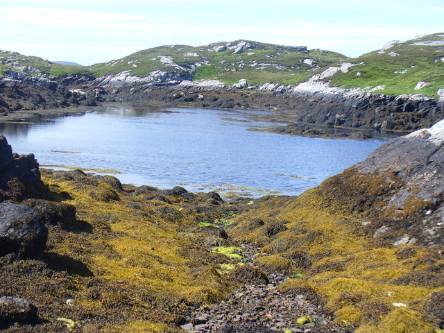
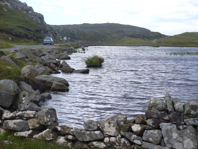
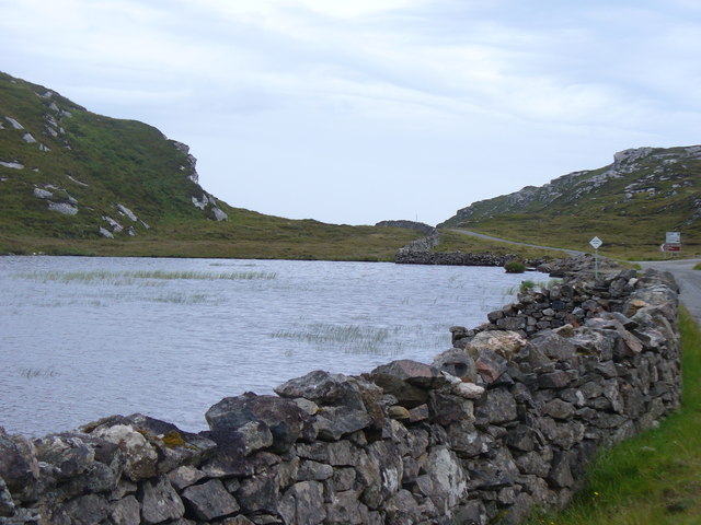
With a population of around 300 inhabitants, Breaclete offers a peaceful and idyllic setting for residents and visitors alike. The village is surrounded by vast expanses of untouched nature, including rugged mountains, pristine beaches, and picturesque lochs. Its remote location makes it an ideal destination for those seeking tranquility and a break from the hustle and bustle of modern life.

Breaclete is steeped in Gaelic history and culture, with many residents still speaking the language. The village is home to several traditional thatched cottages, which add to its authentic charm. The local community takes great pride in preserving their heritage, and visitors can immerse themselves in traditional music, dance, and storytelling at various events throughout the year.

Outdoor enthusiasts will find plenty to do in Breaclete and its surrounding areas. Hiking, fishing, and birdwatching are popular activities, with the nearby lochs and moorlands teeming with wildlife. The village's coastal location also provides opportunities for water sports such as kayaking and sailing.

Facilities in Breaclete are limited but sufficient for everyday needs. There is a small shop, a post office, and a community center that serves as a hub for social gatherings and events. For more extensive amenities, the nearby town of Stornoway offers a wider range of services, including supermarkets, restaurants, and cultural attractions.

In summary, Breaclete offers a tranquil and picturesque escape in the heart of the Scottish Highlands. Its stunning natural surroundings and rich cultural heritage make it a hidden gem for those seeking an authentic Highland experience.

If you have any feedback on the listing, please let us know in the comments section below.

Breaclete Images

Images are sourced within 2km of 58.229672/-6.8383174 or Grid Reference NB1636. Thanks to Geograph Open Source API. All images are credited.

Old hardstandings at Tob Blar Meadha Abandoned lobster loading hardstandings at the lobster pond.
Old hardstandings at Tob Blar Meadha
Abandoned lobster loading hardstandings at the lobster pond.
Beach north of Bhalasaigh
Sea loch west of Loch Veiravat Although it isn't obvious from here, this is the start of a long channel that leads out to the sea.
Sea loch west of Loch Veiravat
Although it isn't obvious from here, this is the start of a long channel that leads out to the sea.
Moorland and loch on Great Bernera The loch is unnamed on the map, but the Allt Loch an Fheoir flows into it, so this must be Loch an Fheoir.

The houses in the distance are on the road south of Bhalasaigh.
Moorland and loch on Great Bernera
The loch is unnamed on the map, but the Allt Loch an Fheoir flows into it, so this must be Loch an Fheoir. The houses in the distance are on the road south of Bhalasaigh.
Bridge at Bhalasaigh Looking back to the road end on the main island of Great Bernera.
Bridge at Bhalasaigh
Looking back to the road end on the main island of Great Bernera.
War Memorial, Breacleit The memorial stands on a mound at the crossroads in the centre of Breacleit / Breaclete, the capital of Great Bernera / Bearnaraigh. On the skyline is the Bernera Community Centre.
<span class="nowrap"><a title="http://www.uigandbernera.com/" rel="nofollow ugc noopener" href="http://www.uigandbernera.com/">Link</a><img style="margin-left:2px;" alt="External link" title="External link - shift click to open in new window" src="https://s1.geograph.org.uk/img/external.png" width="10" height="10"/></span>
War Memorial, Breacleit
The memorial stands on a mound at the crossroads in the centre of Breacleit / Breaclete, the capital of Great Bernera / Bearnaraigh. On the skyline is the Bernera Community Centre. LinkExternal link
Breacleit, Bernera Summer flowers, church and school in the village centre.
<span class="nowrap"><a title="http://www.uigandbernera.com/" rel="nofollow ugc noopener" href="http://www.uigandbernera.com/">Link</a><img style="margin-left:2px;" alt="External link" title="External link - shift click to open in new window" src="https://s1.geograph.org.uk/img/external.png" width="10" height="10"/></span>
Breacleit, Bernera
Summer flowers, church and school in the village centre. LinkExternal link
Loch Ionail Freshwater loch on the island of Great Bernera / Bearnaraigh.
<span class="nowrap"><a title="http://www.uigandbernera.com/" rel="nofollow ugc noopener" href="http://www.uigandbernera.com/">Link</a><img style="margin-left:2px;" alt="External link" title="External link - shift click to open in new window" src="https://s1.geograph.org.uk/img/external.png" width="10" height="10"/></span>
Loch Ionail
Freshwater loch on the island of Great Bernera / Bearnaraigh. LinkExternal link
Tob Bhalasaigh Tidal lagoon with a mix of rare seaweeds on Great Bernera / Bearnaraigh.
<span class="nowrap"><a title="http://www.uigandbernera.com/" rel="nofollow ugc noopener" href="http://www.uigandbernera.com/">Link</a><img style="margin-left:2px;" alt="External link" title="External link - shift click to open in new window" src="https://s1.geograph.org.uk/img/external.png" width="10" height="10"/></span>
Tob Bhalasaigh
Tidal lagoon with a mix of rare seaweeds on Great Bernera / Bearnaraigh. LinkExternal link
Valasay Bridge Carrying the single track road across an outlet of the tidal lagoon, Tob Bhalasaigh on Great Bernera / Bearnaraigh.
<span class="nowrap"><a title="http://www.uigandbernera.com/" rel="nofollow ugc noopener" href="http://www.uigandbernera.com/">Link</a><img style="margin-left:2px;" alt="External link" title="External link - shift click to open in new window" src="https://s1.geograph.org.uk/img/external.png" width="10" height="10"/></span>
Valasay Bridge
Carrying the single track road across an outlet of the tidal lagoon, Tob Bhalasaigh on Great Bernera / Bearnaraigh. LinkExternal link
Shoreline at Tob Bhalasaigh Rocks and heather at the edge of the tidal lagoon in Valasay.
<span class="nowrap"><a title="http://www.uigandbernera.com/" rel="nofollow ugc noopener" href="http://www.uigandbernera.com/">Link</a><img style="margin-left:2px;" alt="External link" title="External link - shift click to open in new window" src="https://s1.geograph.org.uk/img/external.png" width="10" height="10"/></span>
Shoreline at Tob Bhalasaigh
Rocks and heather at the edge of the tidal lagoon in Valasay. LinkExternal link
Valasay Footbridge The bridge across the tidal Tob Bhalasaigh was built in 1898.
<span class="nowrap"><a title="http://www.uigandbernera.com/" rel="nofollow ugc noopener" href="http://www.uigandbernera.com/">Link</a><img style="margin-left:2px;" alt="External link" title="External link - shift click to open in new window" src="https://s1.geograph.org.uk/img/external.png" width="10" height="10"/></span>
Valasay Footbridge
The bridge across the tidal Tob Bhalasaigh was built in 1898. LinkExternal link
Tidal Lagoon, Valasay Tob Bhalasaigh, on the island of Great Bernera / Bearnaraigh.
<span class="nowrap"><a title="http://www.uigandbernera.com/" rel="nofollow ugc noopener" href="http://www.uigandbernera.com/">Link</a><img style="margin-left:2px;" alt="External link" title="External link - shift click to open in new window" src="https://s1.geograph.org.uk/img/external.png" width="10" height="10"/></span>
Tidal Lagoon, Valasay
Tob Bhalasaigh, on the island of Great Bernera / Bearnaraigh. LinkExternal link
Tob Bhalasaigh from the Footbridge View northwards, along the narrow tidal lagoon, to Tobson 2 kilometres away in the distance.
Tob Bhalasaigh from the Footbridge
View northwards, along the narrow tidal lagoon, to Tobson 2 kilometres away in the distance.
Tob Lathach, Bearnaraigh Small tidal lagoon on the west coast of Great Bernera.
<span class="nowrap"><a title="http://www.uigandbernera.com/" rel="nofollow ugc noopener" href="http://www.uigandbernera.com/">Link</a><img style="margin-left:2px;" alt="External link" title="External link - shift click to open in new window" src="https://s1.geograph.org.uk/img/external.png" width="10" height="10"/></span>
Tob Lathach, Bearnaraigh
Small tidal lagoon on the west coast of Great Bernera. LinkExternal link
Loch Tana Small freshwater loch on Great Bernera / Bearnaraigh with a single track road running alongside it.
<span class="nowrap"><a title="http://www.uigandbernera.com/" rel="nofollow ugc noopener" href="http://www.uigandbernera.com/">Link</a><img style="margin-left:2px;" alt="External link" title="External link - shift click to open in new window" src="https://s1.geograph.org.uk/img/external.png" width="10" height="10"/></span>
Loch Tana
Small freshwater loch on Great Bernera / Bearnaraigh with a single track road running alongside it. LinkExternal link
Loch Tana from the South Freshwater loch with drystane dyke and single track road, Great Bernera / Bearnaraigh.
<span class="nowrap"><a title="http://www.uigandbernera.com/" rel="nofollow ugc noopener" href="http://www.uigandbernera.com/">Link</a><img style="margin-left:2px;" alt="External link" title="External link - shift click to open in new window" src="https://s1.geograph.org.uk/img/external.png" width="10" height="10"/></span>
Loch Tana from the South
Freshwater loch with drystane dyke and single track road, Great Bernera / Bearnaraigh. LinkExternal link
Loch Ruig Sanndabhat Small and reedy freshwater loch below the slopes of Beinn Breacleit, Great Bernera / Bearnaraigh.
<span class="nowrap"><a title="http://www.uigandbernera.com/" rel="nofollow ugc noopener" href="http://www.uigandbernera.com/">Link</a><img style="margin-left:2px;" alt="External link" title="External link - shift click to open in new window" src="https://s1.geograph.org.uk/img/external.png" width="10" height="10"/></span>
Loch Ruig Sanndabhat
Small and reedy freshwater loch below the slopes of Beinn Breacleit, Great Bernera / Bearnaraigh. LinkExternal link
Show me another place!

Breaclete is located at Grid Ref: NB1636 (Lat: 58.229672, Lng: -6.8383174)

Unitary Authority: Na h-Eileanan an Iar

Police Authority: Highlands and Islands

Also known as: Breacleit

What 3 Words

///pool.dame.flickers. Near Carloway, Na h-Eileanan Siar

Related Wikis

Breaclete

Breacleit (or Roulanish; Scottish Gaelic: Breacleit; Old Norse: Breiðiklettr) is the central village on Great Bernera in the Outer Hebrides, Scotland....

Great Bernera

Great Bernera (; Scottish Gaelic: Beàrnaraigh Mòr), often known just as Bernera (Scottish Gaelic: Beàrnaraigh), is an island and community in the Outer...

Dun Bharabhat, Great Bernera

Dun Bharabhat (or Dun Baravat) is an Iron Age galleried dun or "semi-broch" situated on the island of Great Bernera near Lewis in Scotland (grid reference...

Bernera Riot

The Bernera Riot occurred in 1874, on the island of Great Bernera, in Scotland in response to the Highland Clearances. The use of the term 'Bernera Riot...

Nearby Amenities

Located within 500m of 58.229672,-6.8383174
Passing Place
Lat/Long: 58.2305008/-6.8428949
Barrier: cattle_grid
Lat/Long: 58.2276073/-6.8405624
War Memorial
Historic: memorial
Memorial: war_memorial
Lat/Long: 58.2276691/-6.8406383
Passing Place
Lat/Long: 58.2287295/-6.8420015
Bernera Museum
Email: berneramuseum1@gmail.com
Fee: yes
Opening Hours: Mo-Fr 12:00-16:00
Tourism: museum
Website: https://www.visitscotland.com/info/see-do/bernera-museum-p1424221
Wheelchair: yes
Lat/Long: 58.2279363/-6.84186
Recycling
Recycling Clothes: yes
Recycling Glass: yes
Recycling Glass Bottles: yes
Recycling Paper: yes
Recycling Plastic: yes
Lat/Long: 58.2276993/-6.8420015
Passing Place
Lat/Long: 58.2271477/-6.8427523
Source: http://www.geograph.org.uk/photo/2646823
Lat/Long: 58.227341/-6.842447
Passing Place
Lat/Long: 58.2285708/-6.8385691
Passing Place
Lat/Long: 58.2314983/-6.8378924
Passing Place
Lat/Long: 58.2330748/-6.8385093
Passing Place
Lat/Long: 58.2322823/-6.8438078
Barrier: cattle_grid
Lat/Long: 58.2264322/-6.8394885
Barrier: cattle_grid
Lat/Long: 58.2321154/-6.8380481
Post Box
Collection Times: Mo-Fr 08:15; Sa 08:15
Operator: Royal Mail
Operator Wikidata: Q638098
Post Box Mounting: pier
Post Box Type: lamp
Ref: HS2 93
Royal Cypher: scottish_crown
Source: survey
Lat/Long: 58.2272813/-6.8409395
Turning Circle
Lat/Long: 58.2266664/-6.8423347
Doctors
Breaclete Surgery
Healthcare: doctor
Website: https://www.langabhatmedicalpractice.co.uk/
Lat/Long: 58.2278942/-6.8420631
Cafe
Community Cafe
Opening Hours: Mo-Fr 12:00-15:00
Lat/Long: 58.2279394/-6.8416929
Barrier: cattle_grid
Lat/Long: 58.2278641/-6.8415516
Bus Stop
Breaclete
Bus: yes
Naptan AtcoCode: 6010731553
Naptan Bearing: S
Naptan BusStopType: CUS
Naptan CommonName: Village
Naptan Indicator: at
Naptan Landmark: road junction near hall
Naptan NaptanCode: 94723929
Naptan Street: Minor Road
Naptan Verified: no
Public Transport: platform
Source: naptan_import
Lat/Long: 58.2273761/-6.8408465
Breacleit
Name En: Breaclete
Name Gd: Breacleit
Name Non: Breiðiklettr
Place: village
Wikidata: Q3777831
Wikipedia: en:Breaclete
Lat/Long: 58.2276288/-6.8402008
Power: pole
Lat/Long: 58.2321503/-6.8453572
Power: pole
Lat/Long: 58.2316595/-6.845048
Power: pole
Lat/Long: 58.2307979/-6.8444611
Power: pole
Lat/Long: 58.2300956/-6.8440729
Power: pole
Lat/Long: 58.2295514/-6.8437637
Power: pole
Lat/Long: 58.2288824/-6.843419
Power: pole
Lat/Long: 58.2282348/-6.8430542
Power: pole
Lat/Long: 58.2276722/-6.8427337
Power: pole
Lat/Long: 58.2268598/-6.8422429
Power: pole
Lat/Long: 58.2266159/-6.8414953
Power: pole
Lat/Long: 58.2263402/-6.8407844
Power: pole
Lat/Long: 58.2258458/-6.8394504
Power: pole
Lat/Long: 58.2291147/-6.8422787
Power: pole
Lat/Long: 58.2293247/-6.8412525
Power: pole
Lat/Long: 58.2295228/-6.8402663
Power: pole
Lat/Long: 58.2297141/-6.8393481
Power: pole
Lat/Long: 58.2296559/-6.8387304
Power: pole
Lat/Long: 58.229423/-6.8372182
Power: pole
Lat/Long: 58.2294183/-6.8367149
Power: pole
Lat/Long: 58.2293957/-6.8354803
Power: pole
Lat/Long: 58.2295882/-6.8347241
Power: pole
Lat/Long: 58.2337057/-6.8388162
Power: pole
Lat/Long: 58.2332387/-6.8387485
Power: pole
Lat/Long: 58.2327397/-6.8385905
Power: pole
Lat/Long: 58.2321776/-6.8384325
Power: pole
Lat/Long: 58.2316036/-6.8385138
Power: pole
Lat/Long: 58.2313363/-6.8385318
Power: pole
Lat/Long: 58.2306673/-6.8391128
Power: pole
Lat/Long: 58.2303795/-6.8394486
Power: pole
Lat/Long: 58.2312626/-6.8398928
Power: pole
Lat/Long: 58.2313113/-6.8390442
Power: pole
Lat/Long: 58.231448/-6.8380059
Power: pole
Lat/Long: 58.2318829/-6.8381549
Power: pole
Lat/Long: 58.2323261/-6.83827
Power: pole
Lat/Long: 58.2327836/-6.838419
Power: pole
Lat/Long: 58.2308372/-6.8381504
Power: pole
Lat/Long: 58.2308633/-6.8377509
Power: pole
Lat/Long: 58.2295585/-6.8372679
Power: pole
Lat/Long: 58.2273587/-6.8433913
Power: pole
Lat/Long: 58.2268572/-6.8442535
Power: pole
Lat/Long: 58.2266207/-6.839924
Power: pole
Lat/Long: 58.2268322/-6.8392802
Passing Place
Lat/Long: 58.2307006/-6.8380989
Barrier: cattle_grid
Lat/Long: 58.2271064/-6.8407998
Charging Station
Capacity: 2
Operator: ChargePlace Scotland
Operator Wikidata: Q105359316
Ref: 52989
Socket Type2 Output: 22 kW
Website: https://chargeplacescotland.org/cpmap/chargepoint/621036/
Lat/Long: 58.2278413/-6.8419003
The data included in this document is from www.openstreetmap.org. The data is made available under ODbL.

Have you been to Breaclete?

Leave your review of Breaclete below (or comments, questions and feedback).