Wickham Street

Settlement in Suffolk Mid Suffolk

England

Wickham Street

Church of St Andrew, Wickham Skeith <span class="nowrap"><a title="https://historicengland.org.uk/listing/the-list/list-entry/1352521?section=official-list-entry" rel="nofollow ugc noopener" href="https://historicengland.org.uk/listing/the-list/list-entry/1352521?section=official-list-entry">Link</a><img style="margin-left:2px;" alt="External link" title="External link - shift click to open in new window" src="https://s1.geograph.org.uk/img/external.png" width="10" height="10"/></span>
Church of St Andrew, Wickham Skeith Credit: Sandy Gerrard

Wickham Street is a small village located in the county of Suffolk, England. Situated in the Babergh district, the village is nestled in the picturesque countryside, surrounded by fields and meadows. Wickham Street is known for its tranquil and idyllic setting, making it a popular destination for those seeking a peaceful retreat away from the hustle and bustle of city life.

The village itself is characterized by its charming traditional cottages and historic buildings, which give it a distinct rural charm. The local community is close-knit, fostering a strong sense of belonging and camaraderie among its residents. Wickham Street is home to a small but vibrant population, with a range of ages and backgrounds represented.

Despite its small size, the village boasts a few amenities to cater to the needs of its residents. There is a local pub, The Red Lion, where locals and visitors can enjoy a pint and traditional pub food. Additionally, there is a village hall that hosts various events and activities throughout the year, serving as a hub for community gatherings.

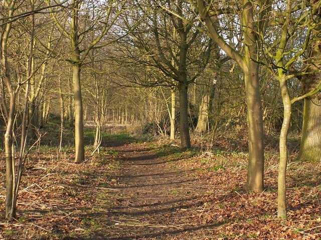
Surrounded by stunning natural beauty, Wickham Street offers numerous opportunities for outdoor activities. The village is surrounded by footpaths and bridleways, making it an excellent location for walking, hiking, and cycling. The nearby countryside also provides ample opportunities for wildlife spotting and nature enthusiasts.

Overall, Wickham Street is a charming and peaceful village that offers a tranquil lifestyle amidst beautiful surroundings. Its strong sense of community and scenic countryside make it an appealing place to call home or visit for a peaceful getaway.

If you have any feedback on the listing, please let us know in the comments section below.

Wickham Street Images

Images are sourced within 2km of 52.28577/1.064618 or Grid Reference TM0969. Thanks to Geograph Open Source API. All images are credited.

Church of St Andrew, Wickham Skeith <span class="nowrap"><a title="https://historicengland.org.uk/listing/the-list/list-entry/1352521?section=official-list-entry" rel="nofollow ugc noopener" href="https://historicengland.org.uk/listing/the-list/list-entry/1352521?section=official-list-entry">Link</a><img style="margin-left:2px;" alt="External link" title="External link - shift click to open in new window" src="https://s1.geograph.org.uk/img/external.png" width="10" height="10"/></span>
Church of St Andrew, Wickham Skeith
Rood Loft Stair at Church of St Andrew, Wickham Skeith <span class="nowrap"><a title="https://historicengland.org.uk/listing/the-list/list-entry/1352521?section=official-list-entry" rel="nofollow ugc noopener" href="https://historicengland.org.uk/listing/the-list/list-entry/1352521?section=official-list-entry">Link</a><img style="margin-left:2px;" alt="External link" title="External link - shift click to open in new window" src="https://s1.geograph.org.uk/img/external.png" width="10" height="10"/></span>
Rood Loft Stair at Church of St Andrew, Wickham Skeith
Font at Church of St Andrew, Wickham Skeith <span class="nowrap"><a title="https://historicengland.org.uk/listing/the-list/list-entry/1352521?section=official-list-entry" rel="nofollow ugc noopener" href="https://historicengland.org.uk/listing/the-list/list-entry/1352521?section=official-list-entry">Link</a><img style="margin-left:2px;" alt="External link" title="External link - shift click to open in new window" src="https://s1.geograph.org.uk/img/external.png" width="10" height="10"/></span>
Font at Church of St Andrew, Wickham Skeith
Doorway at Church of St Andrew, Wickham Skeith <span class="nowrap"><a title="https://historicengland.org.uk/listing/the-list/list-entry/1352521?section=official-list-entry" rel="nofollow ugc noopener" href="https://historicengland.org.uk/listing/the-list/list-entry/1352521?section=official-list-entry">Link</a><img style="margin-left:2px;" alt="External link" title="External link - shift click to open in new window" src="https://s1.geograph.org.uk/img/external.png" width="10" height="10"/></span>
Doorway at Church of St Andrew, Wickham Skeith
Elm Farmhouse, Wickham Skeith <span class="nowrap"><a title="https://historicengland.org.uk/listing/the-list/list-entry/1032198?section=official-list-entry" rel="nofollow ugc noopener" href="https://historicengland.org.uk/listing/the-list/list-entry/1032198?section=official-list-entry">Link</a><img style="margin-left:2px;" alt="External link" title="External link - shift click to open in new window" src="https://s1.geograph.org.uk/img/external.png" width="10" height="10"/></span>
Elm Farmhouse, Wickham Skeith
Field next to Colsey Wood
Footpath from Thornham Magna to Wickham Skeith
Wickham Road Looking towards Thwaite Suffolk along Wickham road.
Wickham Road
Looking towards Thwaite Suffolk along Wickham road.
Blue Skies And Green Grass Country view photo taken east of Wickham Skeith Suffolk.
Blue Skies And Green Grass
Country view photo taken east of Wickham Skeith Suffolk.
One After Another A line of pylons crosses the Suffolk countryside just north of Mendlesham Suffolk.
One After Another
A line of pylons crosses the Suffolk countryside just north of Mendlesham Suffolk.
Farm track through pastures at Wickham Skeith The track serves as a public footpath.
Farm track through pastures at Wickham Skeith
The track serves as a public footpath.
Footpath to Wickham Skeith This public footpath follows a track and links Colsey Wood with Wickham Skeith. The trees seen in the background surround St Andrew's church, a dry ford can be seen in the foreground.
Footpath to Wickham Skeith
This public footpath follows a track and links Colsey Wood with Wickham Skeith. The trees seen in the background surround St Andrew's church, a dry ford can be seen in the foreground.
Wickham Skeith church
Path on the Thornham Estate Thornham Estate is a beautiful place to walk and is open to the public each day. There are 12 miles of footpaths through ancient parkland, woodland, farmland and water meadows.
Path on the Thornham Estate
Thornham Estate is a beautiful place to walk and is open to the public each day. There are 12 miles of footpaths through ancient parkland, woodland, farmland and water meadows.
Redhouse Farm, Gislingham Bales of hay stacked high outside the farm buildings, viewed from the minor road between Finningham and Gislingham.
Redhouse Farm, Gislingham
Bales of hay stacked high outside the farm buildings, viewed from the minor road between Finningham and Gislingham.
Footpath through copse This unnamed copse lies south of Eastlands Farm, Finningham.  The path runs through the centre.
Footpath through copse
This unnamed copse lies south of Eastlands Farm, Finningham. The path runs through the centre.
Footpath near Eastlands Farm This path commences from the track to Eastlands Farm, heading east through this unnamed copse.
Footpath near Eastlands Farm
This path commences from the track to Eastlands Farm, heading east through this unnamed copse.
Footpath to Wickham Green This path leads south-east from the minor road between Finningham and Wickham Skeith.
Footpath to Wickham Green
This path leads south-east from the minor road between Finningham and Wickham Skeith.
Show me another place!

Wickham Street is located at Grid Ref: TM0969 (Lat: 52.28577, Lng: 1.064618)

Administrative County: Suffolk

District: Mid Suffolk

Police Authority: Suffolk

What 3 Words

///rely.sensibly.enchanted. Near Bacton, Suffolk

Related Wikis

Wickham Skeith

Wickham Skeith is a village and civil parish in Suffolk, England, about 5 miles to the west of Eye and about 3 miles east of Finningham. == History... ==

Hartismere Hundred

Hartismere was a hundred of Suffolk, that later gave its name to a poor law union, a rural sanitary district, and the Hartismere Rural District. Listed...

Gislingham

Gislingham is a village and civil parish in the Mid Suffolk district of Suffolk in eastern England. == History == Gislingham is situated around the area...

Thornham Magna

Thornham Magna is the larger sister village of Thornham Parva on the former estate of Thornham Hall, the Henniker family seat, in Suffolk. It is about...

Finningham

Finningham is a village and civil parish in the Mid Suffolk district of Suffolk in the East of England, located approximately 7.5 miles north of Stowmarket...

Stoke Ash

Stoke Ash is a village and civil parish in the Mid Suffolk district of Suffolk in eastern England. Located around six miles south of Diss, in 2011 its...

Thwaite, Suffolk

Thwaite is a rural village in Suffolk, England. Thwaite is based on and around the A140 road, midway between Suffolk's county town of Ipswich and the city...

St Mary's Church, Thornham Parva

St Mary's Church is a medieval church in Thornham Parva, Suffolk, England. Much of the fabric dates from the 12th century, and it is a Grade I listed building...

Nearby Amenities

Located within 500m of 52.28577,1.064618
Bus Stop
The Street
Bus: yes
Naptan AtcoCode: 390040175
Naptan Bearing: W
Naptan BusStopType: CUS
Naptan CommonName: The Street
Naptan Indicator: adj
Naptan Landmark: The Street
Naptan NaptanCode: sufawdwa
Naptan Street: Workhouse Road
Naptan Verified: no
Public Transport: platform
Source: naptan_import
Lat/Long: 52.2863386/1.0642961
Bus Stop
The Street
Bus: yes
Naptan AtcoCode: 390040176
Naptan Bearing: E
Naptan BusStopType: CUS
Naptan CommonName: The Street
Naptan Indicator: opp
Naptan Landmark: The Street
Naptan NaptanCode: sufawdwd
Naptan Street: Workhouse Street
Naptan Verified: no
Public Transport: platform
Source: naptan_import
Lat/Long: 52.2865084/1.0643371
Bus Stop
Pumping Station
Bus: yes
Naptan AtcoCode: 390041024
Naptan Bearing: N
Naptan BusStopType: CUS
Naptan CommonName: Pumping Station
Naptan Indicator: opp
Naptan Landmark: Pumping Station
Naptan NaptanCode: sufjpgdg
Naptan Street: The Broadway
Naptan Verified: no
Public Transport: platform
Source: naptan_import
Lat/Long: 52.286413/1.0652398
Bus Stop
Pumping Station
Bus: yes
Naptan AtcoCode: 390041025
Naptan Bearing: S
Naptan BusStopType: CUS
Naptan CommonName: Pumping Station
Naptan Indicator: adj
Naptan Landmark: Pumping Station
Naptan NaptanCode: sufjpgda
Naptan Street: The Broadway
Naptan Verified: no
Public Transport: platform
Source: naptan_import
Lat/Long: 52.2864682/1.0655369
Give Way
Lat/Long: 52.2865982/1.0653785
Ford: yes
Lat/Long: 52.2868269/1.064305
Give Way
Lat/Long: 52.2864568/1.0644722
Give Way
Lat/Long: 52.2861364/1.065457
Post Box
Collection Times: Mo-Fr 09:00; Sa 07:00
Operator: Royal Mail
Post Box Mounting: wooden_post
Post Box Type: lamp
Ref: IP23 7156D
Royal Cypher: EIIR
Royal Cypher Wikidata: Q33102113
Lat/Long: 52.2861815/1.0612428
The data included in this document is from www.openstreetmap.org. The data is made available under ODbL.

Have you been to Wickham Street?

Leave your review of Wickham Street below (or comments, questions and feedback).