Weston

Settlement in Lincolnshire South Holland

England

Weston

Harrox House, Moulton Dates from the late eighteenth century <span class="nowrap"><a title="https://historicengland.org.uk/listing/the-list/list-entry/1064506" rel="nofollow ugc noopener" href="https://historicengland.org.uk/listing/the-list/list-entry/1064506">Link</a><img style="margin-left:2px;" alt="External link" title="External link - shift click to open in new window" src="https://s1.geograph.org.uk/img/external.png" width="10" height="10"/></span>
Harrox House, Moulton Credit: Jonathan Thacker

Weston is a small village located in the county of Lincolnshire, England. Situated approximately 10 miles north of Lincoln, it is part of the West Lindsey district. With a population of around 500 residents, Weston boasts a tranquil and picturesque setting, surrounded by lush green fields and rolling hills.

The village dates back to the medieval period and retains much of its historical charm. It features a mix of traditional stone-built cottages and more modern houses, giving it a unique character. The village center is home to a few local amenities, including a post office, a village hall, and a cozy pub.

Nature enthusiasts will find plenty to explore in Weston, with the nearby Whisby Nature Park offering a diverse range of wildlife and scenic trails. The park is popular for bird-watching, as it serves as a habitat for various species throughout the year.

Weston is also well-connected to surrounding areas, with easy access to the A46 road, which links it to Lincoln and other nearby towns. This makes it an ideal location for commuters seeking a peaceful village lifestyle while remaining within reach of larger urban centers.

Overall, Weston, Lincolnshire, is a charming and tranquil village, rich in history and natural beauty. Its small population and idyllic surroundings make it an attractive place for those seeking a peaceful and rural lifestyle.

If you have any feedback on the listing, please let us know in the comments section below.

Weston Images

Images are sourced within 2km of 52.80662/-0.086162612 or Grid Reference TF2924. Thanks to Geograph Open Source API. All images are credited.

Harrox House, Moulton Dates from the late eighteenth century <span class="nowrap"><a title="https://historicengland.org.uk/listing/the-list/list-entry/1064506" rel="nofollow ugc noopener" href="https://historicengland.org.uk/listing/the-list/list-entry/1064506">Link</a><img style="margin-left:2px;" alt="External link" title="External link - shift click to open in new window" src="https://s1.geograph.org.uk/img/external.png" width="10" height="10"/></span>
Harrox House, Moulton
Dates from the late eighteenth century LinkExternal link
Now that's one tall windmill! Three images stitched together in order to take in the whole of Britain's tallest mill, Moulton Windmill.  I now have a stiff neck!
Now that's one tall windmill!
Three images stitched together in order to take in the whole of Britain's tallest mill, Moulton Windmill. I now have a stiff neck!
Moulton Fish & Chips What a pity it was closed. I could have done with a nice hot lunch.  
It might have been sunny, but the NW wind was cold and quite strong.
Moulton Fish & Chips
What a pity it was closed. I could have done with a nice hot lunch. It might have been sunny, but the NW wind was cold and quite strong.
All Saint's Church, Moulton, Lincolnshire “The Queen of the Fens” dates back to about 1180, the spire is about 158 feet high.
All Saint's Church, Moulton, Lincolnshire
“The Queen of the Fens” dates back to about 1180, the spire is about 158 feet high.
Junction West Cob Gate and Station Road, Moulton
Moulton Windmill The tallest tower mill in the United Kingdom.

Dating back to 1822 it is Grade I listed and 9 stories high. For more details see; <span class="nowrap"><a title="https://en.wikipedia.org/wiki/Moulton_Windmill" rel="nofollow ugc noopener" href="https://en.wikipedia.org/wiki/Moulton_Windmill">Link</a><img style="margin-left:2px;" alt="External link" title="External link - shift click to open in new window" src="https://s1.geograph.org.uk/img/external.png" width="10" height="10"/></span>
Moulton Windmill
The tallest tower mill in the United Kingdom. Dating back to 1822 it is Grade I listed and 9 stories high. For more details see; LinkExternal link
Moulton Windmill The tallest tower mill in the United Kingdom.

Dating back to 1822 it is Grade I listed and 9 stories high.
Moulton Windmill
The tallest tower mill in the United Kingdom. Dating back to 1822 it is Grade I listed and 9 stories high.
Moulton Church and Windmill: aerial 2023 (1) Windmill is the tallest tower mill in the United Kingdom.

Dated 1822 it is Grade I listed and 9 stories high. 

New sails were fitted on 21 November 2011 to complete the restoration of the mill. The community restoration took 14 years to complete at a cost of nearly £2m.

See: <span class="nowrap"><a title="https://en.wikipedia.org/wiki/Moulton_Windmill" rel="nofollow ugc noopener" href="https://en.wikipedia.org/wiki/Moulton_Windmill">Link</a><img style="margin-left:2px;" alt="External link" title="External link - shift click to open in new window" src="https://s1.geograph.org.uk/img/external.png" width="10" height="10"/></span>
Moulton Church and Windmill: aerial 2023 (1)
Windmill is the tallest tower mill in the United Kingdom. Dated 1822 it is Grade I listed and 9 stories high. New sails were fitted on 21 November 2011 to complete the restoration of the mill. The community restoration took 14 years to complete at a cost of nearly £2m. See: LinkExternal link
Moulton Windmill: aerial 2023 (1) The tallest tower mill in the United Kingdom.

Dated 1822 it is Grade I listed and 9 stories high. 

New sails were fitted on 21 November 2011 to complete the restoration of the mill. The community restoration took 14 years to complete at a cost of nearly £2m.

See: <span class="nowrap"><a title="https://en.wikipedia.org/wiki/Moulton_Windmill" rel="nofollow ugc noopener" href="https://en.wikipedia.org/wiki/Moulton_Windmill">Link</a><img style="margin-left:2px;" alt="External link" title="External link - shift click to open in new window" src="https://s1.geograph.org.uk/img/external.png" width="10" height="10"/></span>
Moulton Windmill: aerial 2023 (1)
The tallest tower mill in the United Kingdom. Dated 1822 it is Grade I listed and 9 stories high. New sails were fitted on 21 November 2011 to complete the restoration of the mill. The community restoration took 14 years to complete at a cost of nearly £2m. See: LinkExternal link
Moulton Church and Windmill: aerial 2023 (2) Windmill is the tallest tower mill in the United Kingdom.

Dated 1822 it is Grade I listed and 9 stories high. 

New sails were fitted on 21 November 2011 to complete the restoration of the mill. The community restoration took 14 years to complete at a cost of nearly £2m.

See: <span class="nowrap"><a title="https://en.wikipedia.org/wiki/Moulton_Windmill" rel="nofollow ugc noopener" href="https://en.wikipedia.org/wiki/Moulton_Windmill">Link</a><img style="margin-left:2px;" alt="External link" title="External link - shift click to open in new window" src="https://s1.geograph.org.uk/img/external.png" width="10" height="10"/></span>
Moulton Church and Windmill: aerial 2023 (2)
Windmill is the tallest tower mill in the United Kingdom. Dated 1822 it is Grade I listed and 9 stories high. New sails were fitted on 21 November 2011 to complete the restoration of the mill. The community restoration took 14 years to complete at a cost of nearly £2m. See: LinkExternal link
Moulton Windmill: aerial 2023 (2) The tallest tower mill in the United Kingdom.

Dated 1822 it is Grade I listed and 9 stories high. 

New sails were fitted on 21 November 2011 to complete the restoration of the mill. The community restoration took 14 years to complete at a cost of nearly £2m.

See: <span class="nowrap"><a title="https://en.wikipedia.org/wiki/Moulton_Windmill" rel="nofollow ugc noopener" href="https://en.wikipedia.org/wiki/Moulton_Windmill">Link</a><img style="margin-left:2px;" alt="External link" title="External link - shift click to open in new window" src="https://s1.geograph.org.uk/img/external.png" width="10" height="10"/></span>
Moulton Windmill: aerial 2023 (2)
The tallest tower mill in the United Kingdom. Dated 1822 it is Grade I listed and 9 stories high. New sails were fitted on 21 November 2011 to complete the restoration of the mill. The community restoration took 14 years to complete at a cost of nearly £2m. See: LinkExternal link
Moulton Church and Windmill: aerial 2023 (3) Windmill is the tallest tower mill in the United Kingdom.

Dated 1822 it is Grade I listed and 9 stories high. 

New sails were fitted on 21 November 2011 to complete the restoration of the mill. The community restoration took 14 years to complete at a cost of nearly £2m.

See: <span class="nowrap"><a title="https://en.wikipedia.org/wiki/Moulton_Windmill" rel="nofollow ugc noopener" href="https://en.wikipedia.org/wiki/Moulton_Windmill">Link</a><img style="margin-left:2px;" alt="External link" title="External link - shift click to open in new window" src="https://s1.geograph.org.uk/img/external.png" width="10" height="10"/></span>
Moulton Church and Windmill: aerial 2023 (3)
Windmill is the tallest tower mill in the United Kingdom. Dated 1822 it is Grade I listed and 9 stories high. New sails were fitted on 21 November 2011 to complete the restoration of the mill. The community restoration took 14 years to complete at a cost of nearly £2m. See: LinkExternal link
Moulton Church and Windmill: aerial 2023 (4)
Moulton Windmill: aerial 2023 (3)
Park House Park, Moulton: aerial 2023 (1) See: <span class="nowrap"><a title="https://www.heritagegateway.org.uk/Gateway/Results_Single.aspx?uid=MLI92280&resourceID=1006" rel="nofollow ugc noopener" href="https://www.heritagegateway.org.uk/Gateway/Results_Single.aspx?uid=MLI92280&resourceID=1006">Link</a><img style="margin-left:2px;" alt="External link" title="External link - shift click to open in new window" src="https://s1.geograph.org.uk/img/external.png" width="10" height="10"/></span>
Park House Park, Moulton: aerial 2023 (1)
See: LinkExternal link
Park House Park, Moulton: aerial 2023 (2)  See: <span class="nowrap"><a title="https://www.heritagegateway.org.uk/Gateway/Results_Single.aspx?uid=MLI92280&resourceID=1006" rel="nofollow ugc noopener" href="https://www.heritagegateway.org.uk/Gateway/Results_Single.aspx?uid=MLI92280&resourceID=1006">Link</a><img style="margin-left:2px;" alt="External link" title="External link - shift click to open in new window" src="https://s1.geograph.org.uk/img/external.png" width="10" height="10"/></span>
Park House Park, Moulton: aerial 2023 (2)
See: LinkExternal link
Farm track off Low Gate
Straw stacks off Low Gate
Show me another place!

Weston is located at Grid Ref: TF2924 (Lat: 52.80662, Lng: -0.086162612)

Division: Parts of Holland

Administrative County: Lincolnshire

District: South Holland

Police Authority: Lincolnshire

What 3 Words

///rigid.relieves.proved. Near Whaplode, Lincolnshire

Nearby Locations

Weston

Related Wikis

Weston, Lincolnshire

Weston is a village and civil parish in the South Holland district of Lincolnshire, England. It is situated approximately 2 miles (3 km) north-east from...
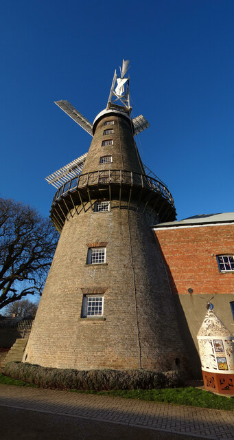
Moulton Windmill

Moulton Windmill in the Lincolnshire village of Moulton, between Spalding and Holbeach is a restored windmill claimed to be the tallest tower mill in the...

Moulton, Lincolnshire

Moulton is a village in the civil parish of The Moultons, in the South Holland district of Lincolnshire, England. It is situated on the A151 and B1537...

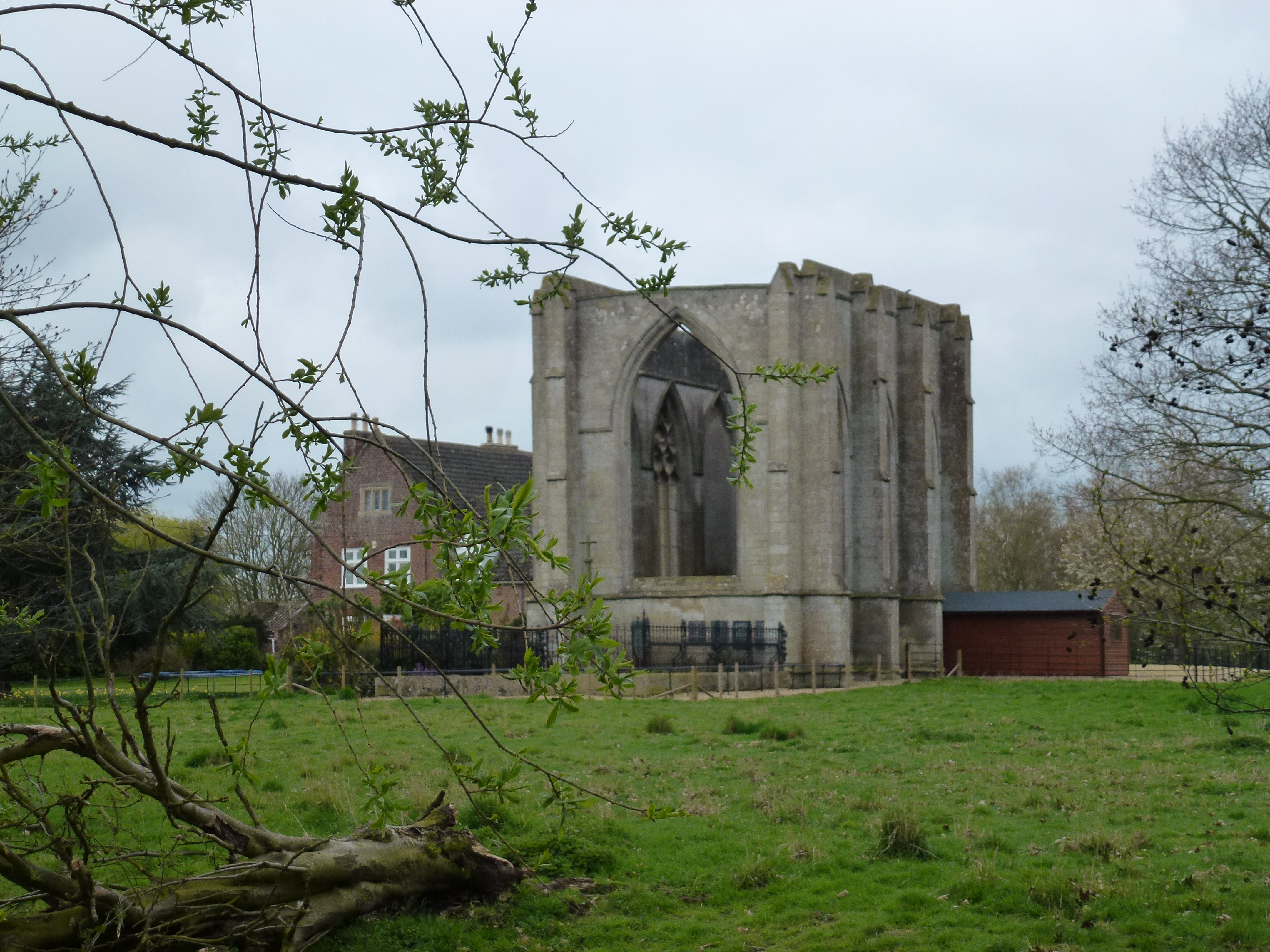
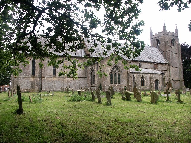
Wykeham, Weston, Lincolnshire

Wykeham /ˈwɪk.əm/ is a deserted medieval village in the civil parish of Weston in the South Holland district of Lincolnshire, England. Wykeham is the...

Moulton railway station (Lincolnshire)

Moulton (Lincolnshire) railway station was a station in Moulton, Lincolnshire. Built by the Norwich and Spalding Railway, (later Midland and Great Northern...

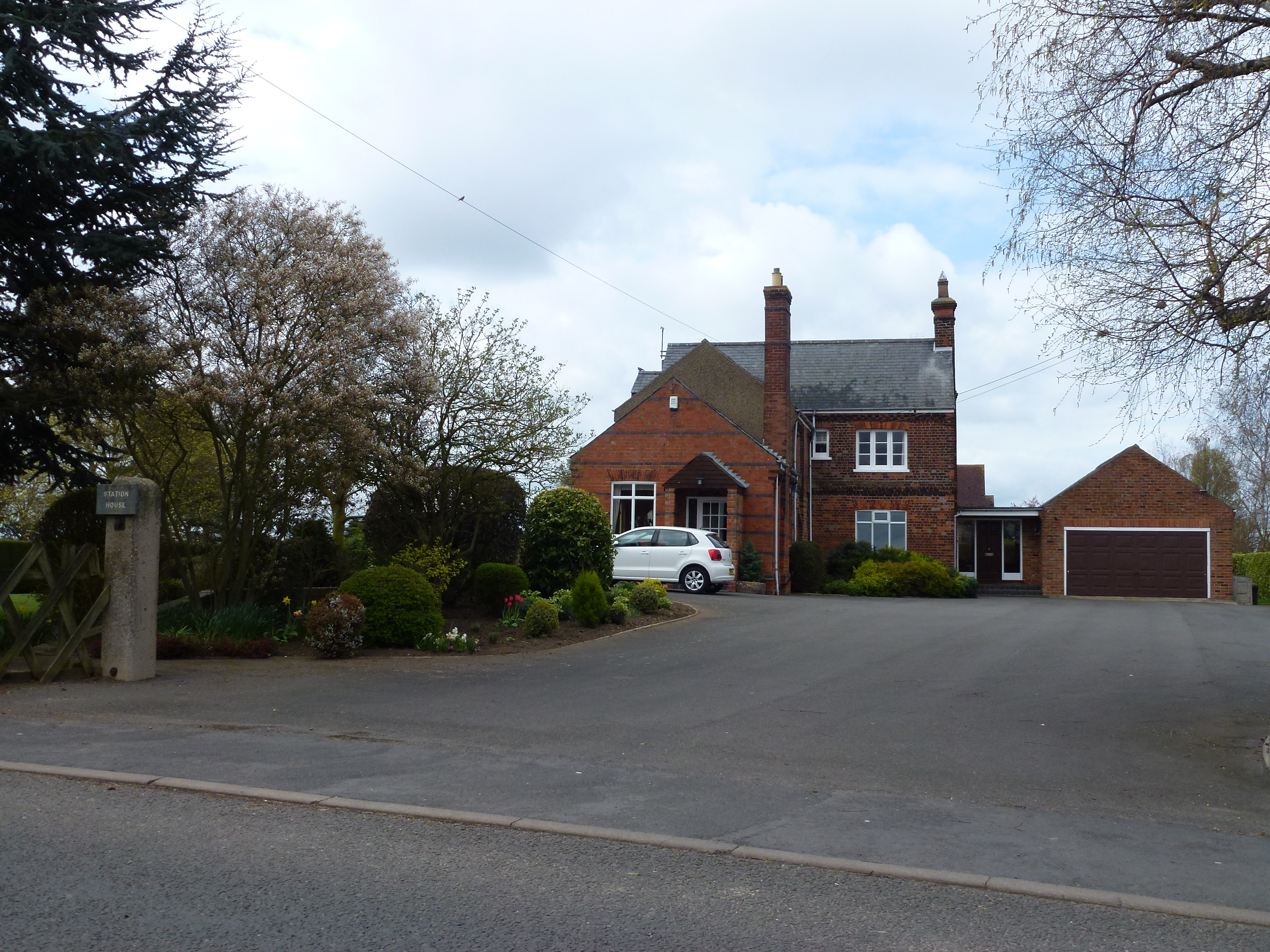
Weston railway station (Lincolnshire)

Weston railway station was a station in Weston, Lincolnshire on the Midland and Great Northern Joint Railway, Built by the Norwich and Spalding Railway...

Spalding Power Station

Spalding Power Station is a 860 MW gas-fired power station one mile north of Spalding on West Marsh Road close to the River Welland. The current site provides...
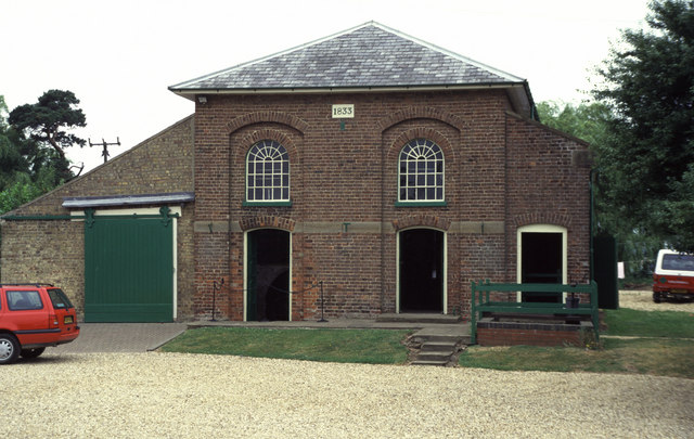
Pinchbeck Engine

The Pinchbeck Engine is a drainage engine, a rotative beam engine built in 1833 to drain Pinchbeck Marsh, to the north of Spalding, Lincolnshire, in England...

Nearby Amenities

Located within 500m of 52.80662,-0.086162612
Weston
Is In: Lincolnshire, England, UK
Place: village
Wikidata: Q7989361
Lat/Long: 52.8056758/-0.0865961
Bus Stop
The Chequers PH, opp
Bus: yes
Naptan AtcoCode: 270000009468
Naptan Bearing: SW
Naptan CommonName: The Chequers PH
Naptan Indicator: opp
Naptan Landmark: The Chequers PH
Naptan NaptanCode: linjawtw
Naptan Street: High Road
Naptan Verified: no
Public Transport: platform
Source: naptan_import
Lat/Long: 52.8080208/-0.0839525
Bus Stop
Wimberley Close, adj
Bus: yes
Naptan AtcoCode: 270002701089
Naptan Bearing: SW
Naptan CommonName: Wimberley Close
Naptan Indicator: adj
Naptan Landmark: Wimberley Close
Naptan Street: High Road
Naptan Verified: no
Public Transport: platform
Source: naptan_import
Lat/Long: 52.8057706/-0.088265
Bus Stop
Wimberley Close, opp
Bus: yes
Naptan AtcoCode: 270002701091
Naptan Bearing: NE
Naptan CommonName: Wimberley Close
Naptan Indicator: opp
Naptan Landmark: Wimberley Close
Naptan Street: High Road
Naptan Verified: no
Public Transport: platform
Source: naptan_import
Lat/Long: 52.8059576/-0.0881529
Bus Stop
The Chequers PH, adj
Bus: yes
Naptan AtcoCode: 2700LWC02216
Naptan Bearing: NE
Naptan CommonName: The Chequers PH
Naptan Indicator: adj
Naptan Landmark: The Chequers PH
Naptan NaptanCode: linapjwa
Naptan Street: High Road
Naptan Verified: no
Public Transport: platform
Source: naptan_import
Lat/Long: 52.8081298/-0.0840219
Post Box
Collection Times: Mo-Fr 16:30; Sa 12:00
Operator: Royal Mail
Operator Wikidata: Q638098
Post Box Type: pillar
Ref: PE12 23
Source: Stop-motion GPS
Lat/Long: 52.808353/-0.082882
Post Office
Weston Village Stores
Addr City: Spalding
Addr Country: GB
Addr Housenumber: 1
Addr Postcode: PE12 6HS
Addr Street: Small Drove
Addr Suburb: Weston
Fhrs Authority: South Holland
Fhrs Id: 242896
Fhrs Local Authority Id: 4897
Ref Pol Id: 10710
Shop: convenience
Source: local knowl; interpolation from GPS
Lat/Long: 52.8082907/-0.082711
Note: End of Public Highway
Lat/Long: 52.8086491/-0.0877999
Church Farm
Place: farm
Source: Bing
Lat/Long: 52.8089588/-0.0830074
Leisure: playground
Lat/Long: 52.8025522/-0.0852017
Generator Method: photovoltaic
Generator Output Electricity: yes
Generator Source: solar
Generator Type: solar_photovoltaic_panel
Location: roof
Power: generator
Lat/Long: 52.804904/-0.0912715
Generator Method: photovoltaic
Generator Output Electricity: yes
Generator Source: solar
Generator Type: solar_photovoltaic_panel
Location: roof
Power: generator
Lat/Long: 52.8046948/-0.0886375
Generator Method: photovoltaic
Generator Output Electricity: yes
Generator Source: solar
Generator Type: solar_photovoltaic_panel
Location: roof
Power: generator
Lat/Long: 52.8039413/-0.0879428
Generator Method: photovoltaic
Generator Output Electricity: yes
Generator Source: solar
Generator Type: solar_photovoltaic_panel
Location: roof
Power: generator
Lat/Long: 52.8041456/-0.087393
Generator Method: photovoltaic
Generator Output Electricity: yes
Generator Source: solar
Generator Type: solar_photovoltaic_panel
Location: roof
Power: generator
Lat/Long: 52.8033835/-0.0874305
Generator Method: photovoltaic
Generator Output Electricity: yes
Generator Source: solar
Generator Type: solar_photovoltaic_panel
Location: roof
Power: generator
Lat/Long: 52.8036559/-0.0872696
Generator Method: photovoltaic
Generator Output Electricity: yes
Generator Source: solar
Generator Type: solar_photovoltaic_panel
Location: roof
Power: generator
Lat/Long: 52.8041261/-0.0870094
The data included in this document is from www.openstreetmap.org. The data is made available under ODbL.

Have you been to Weston?

Leave your review of Weston below (or comments, questions and feedback).