West Lulworth

Settlement in Dorset

England

West Lulworth

South West Coast Path, Lulworth Cove The South West Coast Path at Lulworth Cove, on Dorset's Jurassic coastline.
South West Coast Path, Lulworth Cove Credit: Malc McDonald

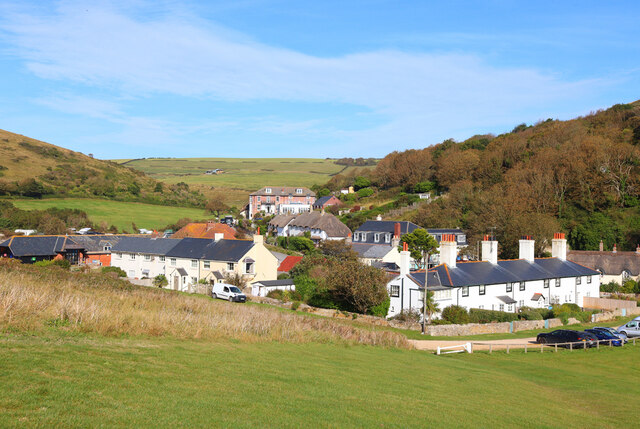
West Lulworth is a small village located on the southern coast of England in the county of Dorset. Situated within the Purbeck district, it is nestled between the towns of Wareham and Weymouth. The village is home to approximately 600 residents and is known for its scenic beauty and proximity to the iconic Lulworth Cove.

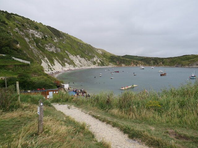
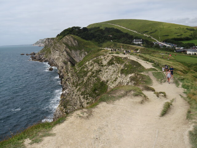
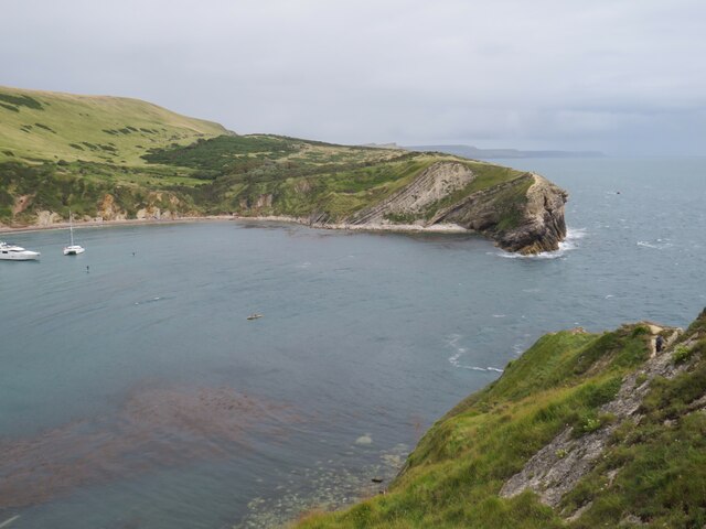
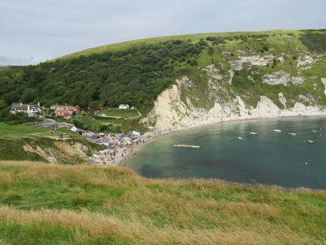
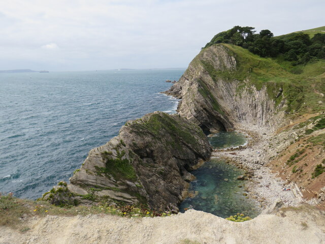
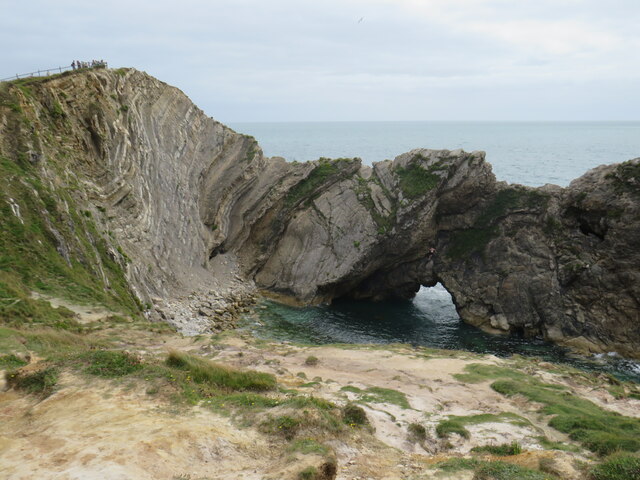
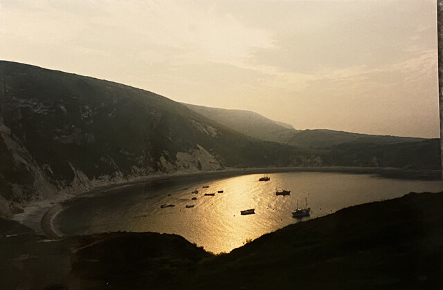
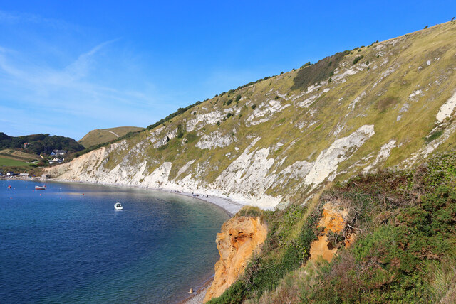
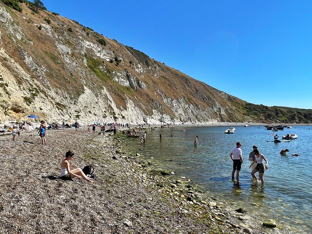
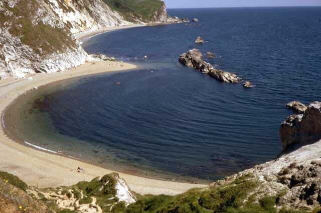
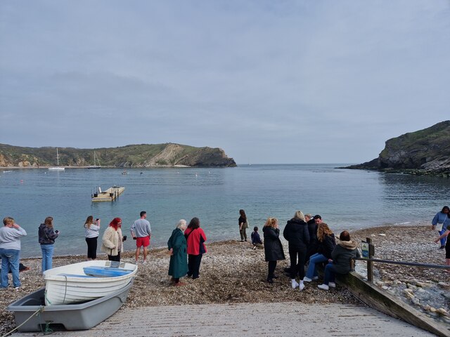
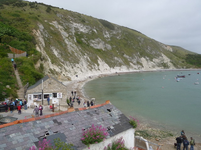
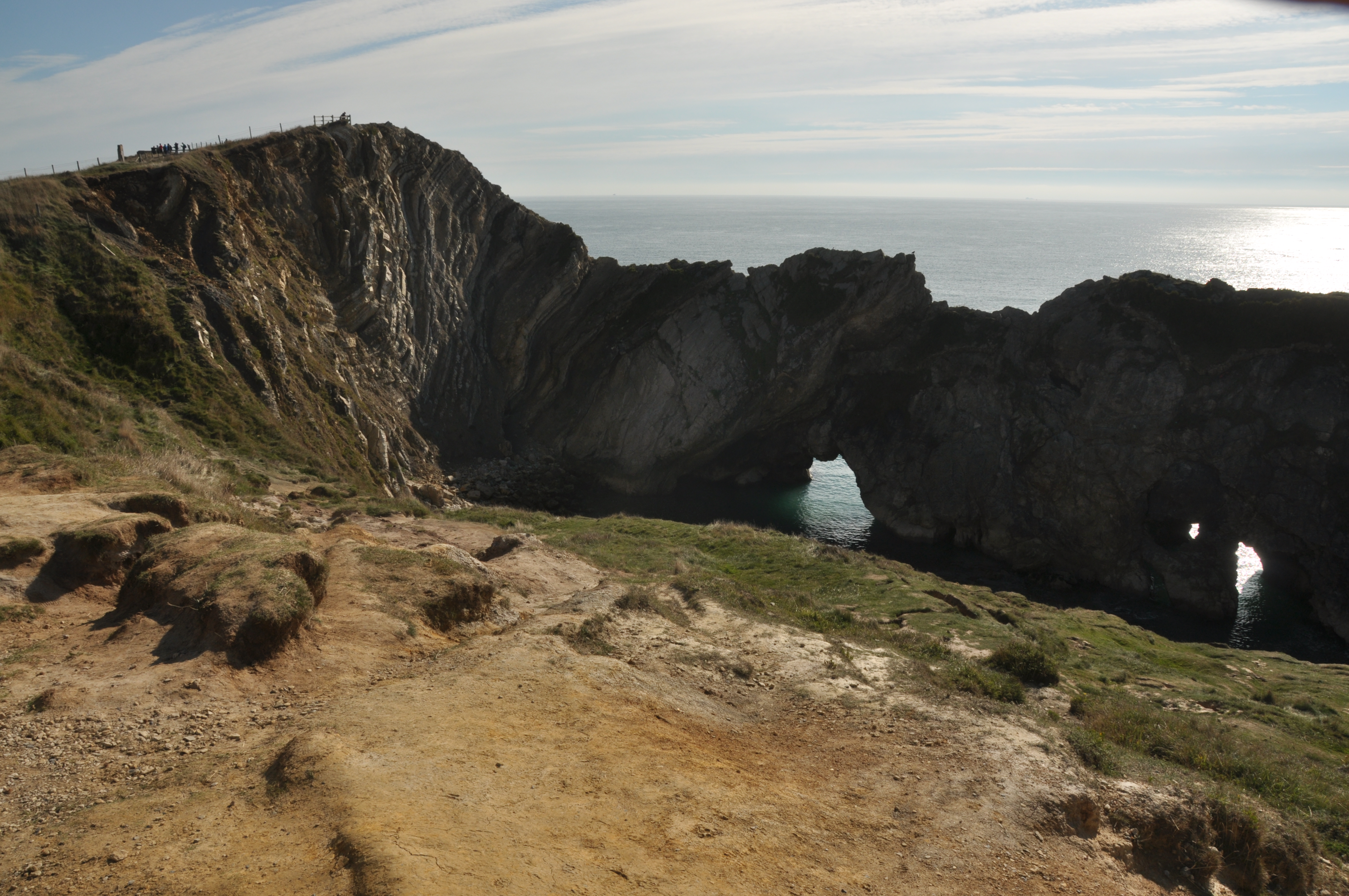
Lulworth Cove, a natural horseshoe-shaped bay, is a major attraction in the area. The cove's crystal-clear waters and stunning limestone cliffs draw in visitors from all over the country. The surrounding Jurassic Coast, a UNESCO World Heritage Site, offers a wealth of geological wonders, including the renowned Durdle Door – a natural limestone arch that juts out into the sea.

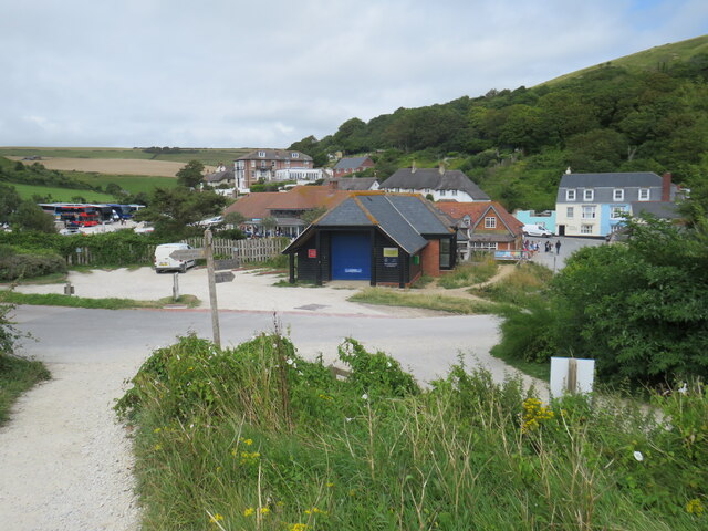
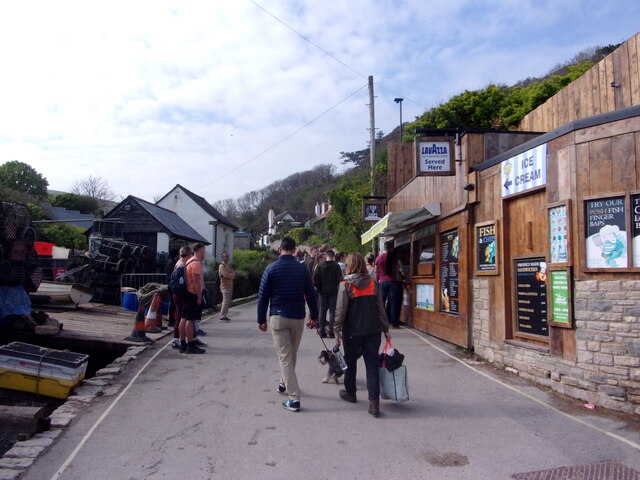
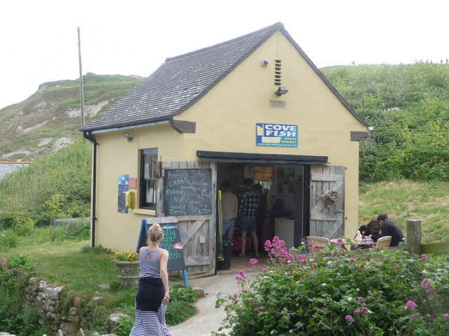
West Lulworth itself is a charming village with a traditional English character. It boasts a range of quaint cottages, some of which date back to the 17th century. The village also features a handful of local businesses, including pubs, cafes, and small shops, catering to both residents and tourists.

Nature enthusiasts will find ample opportunities for outdoor activities in and around West Lulworth. The village is surrounded by beautiful countryside, perfect for hiking, cycling, and exploring. The nearby Lulworth Estate, a privately owned land, offers picturesque walking trails and parkland for visitors to enjoy.

Overall, West Lulworth is a peaceful and picturesque village that offers visitors a chance to immerse themselves in the natural beauty of the Dorset coast. Its close proximity to Lulworth Cove and the Jurassic Coast make it a popular destination for those seeking a quintessential English coastal experience.

If you have any feedback on the listing, please let us know in the comments section below.

West Lulworth Images

Images are sourced within 2km of 50.625401/-2.2496395 or Grid Reference SY8280. Thanks to Geograph Open Source API. All images are credited.

South West Coast Path, Lulworth Cove The South West Coast Path at Lulworth Cove, on Dorset's Jurassic coastline.
South West Coast Path, Lulworth Cove
The South West Coast Path at Lulworth Cove, on Dorset's Jurassic coastline.
Coastline at Lulworth Cove A view of Dorset's Jurassic coastline at Lulworth Cove.

The white scar on the hill in the background is a path, which forms part of the route of the South West Coast Path.
Coastline at Lulworth Cove
A view of Dorset's Jurassic coastline at Lulworth Cove. The white scar on the hill in the background is a path, which forms part of the route of the South West Coast Path.
Mouth of Lulworth Cove The mouth of Lulworth Cove, on Dorset's Jurassic coastline.
Mouth of Lulworth Cove
The mouth of Lulworth Cove, on Dorset's Jurassic coastline.
Lulworth Cove A view over part of Lulworth Cove, on Dorset's Jurassic coastline.
Lulworth Cove
A view over part of Lulworth Cove, on Dorset's Jurassic coastline.
Stair Hole, Lulworth Cove Stair Hole, adjacent to Lulworth Cove on Dorset's Jurassic coastline.  In the distance to the left of the image is the Isle of Portland.
Stair Hole, Lulworth Cove
Stair Hole, adjacent to Lulworth Cove on Dorset's Jurassic coastline. In the distance to the left of the image is the Isle of Portland.
Stair Hole, Lulworth Cove Stair Hole adjacent to Lulworth Cove on Dorset's Jurassic coastline.
Stair Hole, Lulworth Cove
Stair Hole adjacent to Lulworth Cove on Dorset's Jurassic coastline.
South West Coast Path, Lulworth Cove The South West Coast Path at Lulworth Cove in Dorset.
South West Coast Path, Lulworth Cove
The South West Coast Path at Lulworth Cove in Dorset.
South West Coast Path, Lulworth Cove The South West Coast Path at Lulworth Cove, in Dorset.
South West Coast Path, Lulworth Cove
The South West Coast Path at Lulworth Cove, in Dorset.
Lulworth Cove at dawn
West Lulworth Houses in West Lulworth.
West Lulworth
Houses in West Lulworth.
Lulworth Cove Cliffs at Lulworth.
Lulworth Cove
Cliffs at Lulworth.
Lulworth Cove
Lulworth Cove
Lulworth Cove Fairly quiet autumn day.
Lulworth Cove
Fairly quiet autumn day.
Lulworth Cove: late April 2023
Mayday Bank holiday weekend visitors at Lulworth
West Lulworth: Cove Fish A tiny building for a detached shop; it has a 1955 date stone in the gable looks as if it is a former telephone exchange. The shop has a frozen counter and is not a fish-and-chip outlet.
West Lulworth: Cove Fish
A tiny building for a detached shop; it has a 1955 date stone in the gable looks as if it is a former telephone exchange. The shop has a frozen counter and is not a fish-and-chip outlet.
West Lulworth: view over a boathouse roof Looking across the back of the Cove over the roof of a boathouse which looks as if it could do with some repairs. Opposite it at the bottom of the road from the village is the Old Boathouse, now a refreshment shop.
West Lulworth: view over a boathouse roof
Looking across the back of the Cove over the roof of a boathouse which looks as if it could do with some repairs. Opposite it at the bottom of the road from the village is the Old Boathouse, now a refreshment shop.
West Lulworth: the Lulworth Crumple A well-known geological phenomenon at Stair Hole, just by the Cove.
West Lulworth: the Lulworth Crumple
A well-known geological phenomenon at Stair Hole, just by the Cove.
Show me another place!

West Lulworth is located at Grid Ref: SY8280 (Lat: 50.625401, Lng: -2.2496395)

Unitary Authority: Dorset

Police Authority: Dorset

What 3 Words

///shifts.motion.mural. Near Wool, Dorset

Related Wikis

West Lulworth

West Lulworth is a village and civil parish in the English county of Dorset, situated on the English Channel beside Lulworth Cove. In the 2011 census the...

Lulworth

Lulworth is the popular name for an area on the coast of Dorset, South West England notable for its castle and cove. However, there is no actual place...

Lulworth Cove

Lulworth Cove is a cove near the village of West Lulworth, on the Jurassic Coast in Dorset, southern England. The cove is one of the world's finest examples...
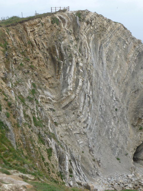
Stair Hole

Stair Hole is a small cove located just west of Lulworth Cove in Dorset, southern England. The folded limestone strata known as the Lulworth crumple are...

Hambury Tout

Hambury Tout is a large chalk hill by the coast near Lulworth, Dorset, England. It overlooks Lulworth Cove to the west. Hambury Tout is the site of an...
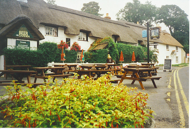
Castle Inn

The Castle Inn is a public house in West Lulworth, Dorset, England, which dates from the 16th century. It was originally called The Green Man, and later...

Dungy Head

Dungy Head is a coastal promontory located west of Lulworth Cove on the Jurassic Coast in Dorset, England. It forms the eastern end of St Oswald's Bay...

Bindon Hill

Bindon Hill is an extensive Iron Age earthwork enclosing a coastal hill area on the Jurassic Coast near Lulworth Cove in Dorset, England, about 19 kilometres...

Nearby Amenities

Located within 500m of 50.625401,-2.2496395
West Lulworth
Is In: Dorset, England, UK
Place: village
Lat/Long: 50.6259195/-2.2505422
Turning Circle
Lat/Long: 50.6235953/-2.2482811
Turning Circle
Lat/Long: 50.626657/-2.2492225
Telephone
Booth: K6
Colour: red
Covered: booth
Listed Status: Grade II
Operator: BT
Operator Wikidata: Q593786
Phone: +44 1929 400246
Ref GB Uprn: 10024754817
Lat/Long: 50.6262598/-2.2458741
Post Box
Collection Times: Mo-Fr 16:45; Sa 08:00
Operator: Royal Mail
Operator Wikidata: Q638098
Post Box Type: lamp
Postal Code: BH20
Ref: BH20 19
Ref GB Uprn: 10015364842
Royal Cypher: EIIR
Royal Cypher Wikidata: Q33102113
Source: survey
Lat/Long: 50.6256669/-2.2433579
Bus Stop
War Memorial
Bench: yes
Bin: no
Bus: yes
Lit: no
Naptan AtcoCode: 1200DOB20840
Naptan Bearing: E
Naptan CommonName: War Memorial
Naptan Indicator: E-bound
Naptan NaptanCode: doratada
Naptan Street: Main Road
Naptan Verified: no
Public Transport: platform
Shelter: yes
Tactile Paving: no
Lat/Long: 50.6260051/-2.2482649
Telephone
Booth: K6
Covered: booth
Note: Has a notice saying it will be removed soon. Notice has been there a long time.
Operator: BT
Operator Wikidata: Q593786
Phone: +44 1929 400364
Lat/Long: 50.6244494/-2.251111
Post Box
Operator: Royal Mail
Operator Wikidata: Q638098
Post Box Type: pillar
Postal Code: BH20
Ref: BH20 87
Ref GB Uprn: 10015292057
Lat/Long: 50.6268782/-2.2444164
Disused Amenity: post_box
Note: very high up on the wall
Post Box Type: wall
Royal Cypher: VR
Lat/Long: 50.626/-2.2482192
Bench
Backrest: yes
Lat/Long: 50.6260843/-2.245576
Entrance: emergency
Lat/Long: 50.6254268/-2.2521076
Historic: memorial
Memorial: war_memorial
Lat/Long: 50.6259452/-2.2484581
Fire Hydrant
Emergency: fire_hydrant
Fire Hydrant Diameter: 100
Fire Hydrant Type: underground
Ref: 271
Source: GPS
Lat/Long: 50.626326/-2.2495518
Fire Hydrant
Emergency: fire_hydrant
Fixme: Is this a real fire hydrant?
Source: GPS+GLONASS
Lat/Long: 50.6265353/-2.2522467
Waste Basket
Waste: dog_excrement
Lat/Long: 50.6266401/-2.249205
Fire Hydrant
Emergency: fire_hydrant
Fire Hydrant Diameter: 100
Fire Hydrant Type: underground
Ref: 13214
Source: GPS
Lat/Long: 50.6267346/-2.2471878
Fire Hydrant
Emergency: fire_hydrant
Fire Hydrant Type: underground
Ref: 9442
Source: GPS
Lat/Long: 50.627155/-2.2444763
Fire Hydrant
Emergency: fire_hydrant
Fire Hydrant Diameter: 99
Fire Hydrant Type: underground
Ref: 1690
Source: GPS
Lat/Long: 50.62638/-2.2432682
Fire Hydrant
Emergency: fire_hydrant
Fire Hydrant Diameter: 90
Fire Hydrant Type: underground
Ref: 13194
Source: GPS
Lat/Long: 50.624086/-2.2512427
Fire Hydrant
Emergency: fire_hydrant
Fire Hydrant Diameter: 4 inch
Fire Hydrant Type: underground
Source: GPS
Lat/Long: 50.6266108/-2.2492662
Fire Hydrant
Emergency: fire_hydrant
Fire Hydrant Type: underground
Source: GPS+GLONASS
Lat/Long: 50.623616/-2.248364
Fire Hydrant
Emergency: fire_hydrant
Fire Hydrant Diameter: 3 inch
Fire Hydrant Type: underground
Ref: 9538
Source: GPS+GLONASS
Lat/Long: 50.626034/-2.247888
Location: underground
Source: GPS+GLONASS
Water: wash_out
Lat/Long: 50.626488/-2.2521975
Location: underground
Source: GPS+GLONASS
Water: wash_out
Lat/Long: 50.6265344/-2.2522588
Fire Hydrant
Emergency: fire_hydrant
Fire Hydrant Diameter: 100
Fire Hydrant Type: underground
Ref: 265
Source: GPS+GLONASS
Lat/Long: 50.627321/-2.254318
Post Box
Collection Times: Mo-Fr 17:00; Sa 08:00
Operator: Royal Mail
Operator Wikidata: Q638098
Post Box Type: pillar
Ref: BH20 106
Royal Cypher: GR
Royal Cypher Wikidata: Q33102273
Source: GPS+GLONASS
Lat/Long: 50.6244555/-2.251199
Bench
Backrest: yes
Source: survey
Lat/Long: 50.6244488/-2.2511716
Fire Hydrant
Emergency: fire_hydrant
Fire Hydrant Type: underground
Ref: 1561
Source: GPS
Lat/Long: 50.6250561/-2.2501864
Camera Direction: 92
Camera Type: fixed
Height: 3
Man Made: surveillance
Surveillance: public
Surveillance Type: camera
Lat/Long: 50.6246546/-2.2516014
Height: 3
Man Made: surveillance
Surveillance: indoor
Surveillance Type: camera
Lat/Long: 50.62468/-2.2516038
Camera Direction: 250
Camera Type: fixed
Height: 3
Man Made: surveillance
Surveillance: public
Surveillance Type: camera
Lat/Long: 50.624714/-2.2514846
Camera Type: dome
Height: 3
Man Made: surveillance
Surveillance: indoor
Surveillance Type: camera
Lat/Long: 50.6247715/-2.2515099
Camera Type: dome
Height: 3
Man Made: surveillance
Surveillance: indoor
Surveillance Type: camera
Lat/Long: 50.6247722/-2.2515213
Camera Direction: 260
Camera Type: fixed
Height: 3
Man Made: surveillance
Surveillance: outdoor
Surveillance Type: camera
Lat/Long: 50.6247819/-2.2515208
Camera Direction: 240
Camera Type: fixed
Height: 3
Man Made: surveillance
Surveillance: public
Surveillance Type: camera
Lat/Long: 50.6256262/-2.2492722
Camera Direction: 60
Camera Type: fixed
Man Made: surveillance
Surveillance: public
Surveillance Type: camera
Lat/Long: 50.62563/-2.249261
Camera Direction: 240
Camera Type: fixed
Height: 3
Man Made: surveillance
Surveillance: public
Surveillance Type: camera
Lat/Long: 50.6256672/-2.2491499
Camera Type: fixed
Height: 3
Man Made: surveillance
Surveillance: public
Surveillance Type: camera
Lat/Long: 50.625764/-2.2490076
Power: switch
Lat/Long: 50.6237142/-2.2502107
Power: switch
Lat/Long: 50.6259585/-2.2486252
Power: switch
Lat/Long: 50.6264644/-2.252397
Frequency: 50
Location: outdoor
Phases: 3
Power: transformer
Ref GB Uprn: 10025376650
Transformer: distribution
Voltage Primary: 11000
Voltage Secondary: 400
Voltage Tertiary: 230
Lat/Long: 50.6276001/-2.2546797
Bench
Backrest: no
Lat/Long: 50.6222867/-2.2528961
Bench
Backrest: no
Lat/Long: 50.6227137/-2.2526621
Camera Direction: 280
Camera Mount: ceiling
Camera Type: fixed
Man Made: surveillance
Surveillance: public
Surveillance Type: camera
Lat/Long: 50.6259855/-2.2477408
Camera Direction: 75
Camera Mount: wall
Camera Type: fixed
Man Made: surveillance
Surveillance: public
Surveillance Type: camera
Lat/Long: 50.6250489/-2.2518208
Camera Direction: 75
Camera Mount: wall
Camera Type: fixed
Man Made: surveillance
Surveillance: public
Surveillance Type: camera
Lat/Long: 50.6249467/-2.2518512
Tourism: guest_house
Lat/Long: 50.6256339/-2.2492448
Bench
Backrest: no
Lat/Long: 50.6218901/-2.2530552
Post Office
West Lulworth Post Office
Addr City: Wareham
Addr Housename: West Lulworth Village Hall
Addr Postcode: BH20 5SG
Addr Street: Church Road
Addr Village: West Lulworth
Opening Hours: Mo,Fr 09:00-12:00; Tu 09:00-11:00
Ref Pol Id: 97091
Source: pol_branch_list_2020-02-20
Lat/Long: 50.6252644/-2.2520886
Entrance: main
Lat/Long: 50.6253085/-2.2520163
Defibrillator
Access: yes
Emergency: defibrillator
Indoor: no
Opening Hours: 24/7
Source: survey
Wheelchair: yes
Lat/Long: 50.6253197/-2.2520142
Waste Basket
Lat/Long: 50.6244495/-2.2511393
Bench
Backrest: yes
Source: survey;gps
Lat/Long: 50.6238798/-2.2513946
Give Way
Direction: forward
Lat/Long: 50.626858/-2.2441812
Give Way
Direction: forward
Lat/Long: 50.6261629/-2.2462113
Give Way
Direction: backward
Lat/Long: 50.6259719/-2.2483326
Give Way
Direction: forward
Lat/Long: 50.6266672/-2.2523633
Addr City: Wareham
Addr Housename: Lynches
Addr Postcode: BH20 5RY
Addr Street: West Road
Addr Suburb: West Lulworth
Lat/Long: 50.6264666/-2.2497779
Addr City: Wareham
Addr Housename: Greenbay
Addr Postcode: BH20 5RY
Addr Street: West Road
Addr Suburb: West Lulworth
Lat/Long: 50.6264632/-2.2498181
Bus Stop
Castle Inn
Bus: yes
Public Transport: platform
Lat/Long: 50.6263313/-2.2457035
Give Way
Direction: backward
Lat/Long: 50.6262798/-2.2432158
The data included in this document is from www.openstreetmap.org. The data is made available under ODbL.

Have you been to West Lulworth?

Leave your review of West Lulworth below (or comments, questions and feedback).