Bennan, West

Settlement in Buteshire

Scotland

Bennan, West

Arrans most southerly point at Bennan Head with Ailsa Craig in the background Photo taken at the exact time of low tide.
Arrans most southerly point at Bennan Head with Ailsa Craig in the background Credit: Brian Robertson

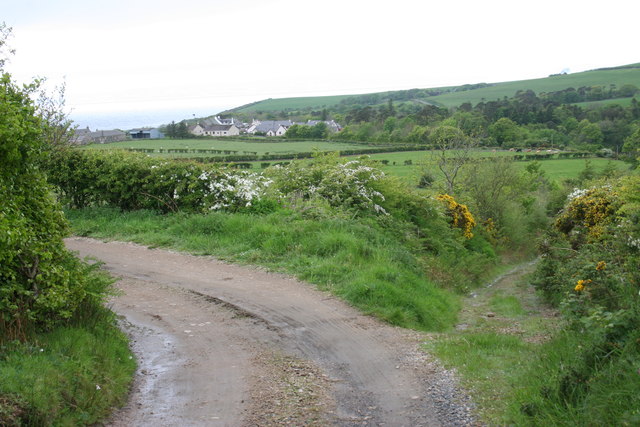
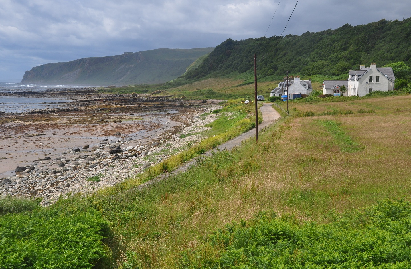
Bennan is a small village located in the West of Buteshire, Scotland. Situated amidst stunning natural landscapes, this tranquil village is surrounded by rolling hills, lush green fields, and breathtaking views of the nearby Bennan Loch. With a population of around 200 residents, Bennan offers a peaceful and close-knit community atmosphere.

The village is primarily residential, with a scattering of traditional stone cottages and a quaint main street. The local economy is driven by agriculture, with many residents engaged in farming and related activities. The fertile soil and favorable weather conditions in the region allow for the cultivation of various crops and livestock farming.

Bennan boasts a strong sense of community, with residents actively involved in local events and organizations. The village hall serves as a central meeting point for social gatherings, community meetings, and recreational activities, fostering a sense of unity among its inhabitants.

For outdoor enthusiasts, Bennan offers plenty of opportunities to explore the surrounding natural beauty. The nearby Bennan Loch is a popular destination for fishing and boating, attracting both locals and visitors alike. Additionally, the rolling hills and well-maintained walking trails provide ample opportunities for hiking and nature walks, allowing residents to immerse themselves in the breathtaking countryside scenery.

While Bennan may be a small village, its charm and natural beauty make it an appealing place to call home for those seeking peace, tranquility, and a strong community spirit.

If you have any feedback on the listing, please let us know in the comments section below.

Bennan, West Images

Images are sourced within 2km of 55.444269/-5.1888879 or Grid Reference NR9821. Thanks to Geograph Open Source API. All images are credited.

Arrans most southerly point at Bennan Head with Ailsa Craig in the background Photo taken at the exact time of low tide.
Arrans most southerly point at Bennan Head with Ailsa Craig in the background
Photo taken at the exact time of low tide.
Rough road from High Kilmory The unmetalled road turning to the left runs from High Kilmory and Kilmory Farm down to the 'main' road (actually a 'yellow' road, but also the only road across the southern end of Arran). The track to the right leads down to Kilmory Church. The houses in the distance form the small village of Kilmory itself.
Rough road from High Kilmory
The unmetalled road turning to the left runs from High Kilmory and Kilmory Farm down to the 'main' road (actually a 'yellow' road, but also the only road across the southern end of Arran). The track to the right leads down to Kilmory Church. The houses in the distance form the small village of Kilmory itself.
Forestry track, Kilbride Hill
Bennan Head
Bennan Head
Old Milestone by the A841, east of Laigh Kilmory Arran by the A841, in parish of Kilmory (Arran District), 20m past track to Lenamhor farm, on seaward side of road.

Inscription reads:-
18
(To Brodick Old Quay)

Surveyed

Milestone Society National ID: AYN_ARR18.
Old Milestone by the A841, east of Laigh Kilmory
Arran by the A841, in parish of Kilmory (Arran District), 20m past track to Lenamhor farm, on seaward side of road. Inscription reads:- 18 (To Brodick Old Quay) Surveyed Milestone Society National ID: AYN_ARR18.
Old Milestone near Shannochie, Kilmory parish Arran by the UC road, in parish of Kilmory (Arran District), just after highest point of road, well back on inland verge, North side of road.

Inscription reads:-
17
(To Brodick Old Quay)

Surveyed

Milestone Society National ID: AYN_ARR17
Old Milestone near Shannochie, Kilmory parish
Arran by the UC road, in parish of Kilmory (Arran District), just after highest point of road, well back on inland verge, North side of road. Inscription reads:- 17 (To Brodick Old Quay) Surveyed Milestone Society National ID: AYN_ARR17
Old Milestone by the A841, Kilmory parish, Arran Milestone on Arran by the A841, in parish of Kilmory (Arran District), 200m from South Bank Farm park adjacent to middle of three bridges, in bank under hedge.

Inscription reads:-
16
(To Brodick Old Quay)

Surveyed

Milestone Society National ID: AYN_ARR16
Old Milestone by the A841, Kilmory parish, Arran
Milestone on Arran by the A841, in parish of Kilmory (Arran District), 200m from South Bank Farm park adjacent to middle of three bridges, in bank under hedge. Inscription reads:- 16 (To Brodick Old Quay) Surveyed Milestone Society National ID: AYN_ARR16
Isle of Arran, Bennan Head
Cows Grazing next to the A841 near Levencorroch The A841 is the only A-road on the Isle of Arran and forms the island's primary transport route, as it connects all the major settlements on the island - Brodick, Lochranza, Blackwaterfoot and Whiting Bay. It used to make a complete circuit of the Isle of Arran on its 55-mile course around the coast. In the early 2000s, the road was reclassified so that the western and southern sides of the route are now unclassified.
Cows Grazing next to the A841 near Levencorroch
The A841 is the only A-road on the Isle of Arran and forms the island's primary transport route, as it connects all the major settlements on the island - Brodick, Lochranza, Blackwaterfoot and Whiting Bay. It used to make a complete circuit of the Isle of Arran on its 55-mile course around the coast. In the early 2000s, the road was reclassified so that the western and southern sides of the route are now unclassified.
A841, Bridge over a Stream near East Bennan The A841 is the only A-road on the Isle of Arran and forms the island's primary transport route, as it connects all the major settlements on the island - Brodick, Lochranza, Blackwaterfoot and Whiting Bay. It used to make a complete circuit of the Isle of Arran on its 55-mile course around the coast. In the early 2000s, the road was reclassified so that the western and southern sides of the route are now unclassified.
A841, Bridge over a Stream near East Bennan
The A841 is the only A-road on the Isle of Arran and forms the island's primary transport route, as it connects all the major settlements on the island - Brodick, Lochranza, Blackwaterfoot and Whiting Bay. It used to make a complete circuit of the Isle of Arran on its 55-mile course around the coast. In the early 2000s, the road was reclassified so that the western and southern sides of the route are now unclassified.
A841 at Southbank Farm The A841 is the only A-road on the Isle of Arran and forms the island's primary transport route, as it connects all the major settlements on the island - Brodick, Lochranza, Blackwaterfoot and Whiting Bay. It used to make a complete circuit of the Isle of Arran on its 55-mile course around the coast. In the early 2000s, the road was reclassified so that the western and southern sides of the route are now unclassified.
A841 at Southbank Farm
The A841 is the only A-road on the Isle of Arran and forms the island's primary transport route, as it connects all the major settlements on the island - Brodick, Lochranza, Blackwaterfoot and Whiting Bay. It used to make a complete circuit of the Isle of Arran on its 55-mile course around the coast. In the early 2000s, the road was reclassified so that the western and southern sides of the route are now unclassified.
Service Bus on the A841 at East Bennan Stagecoach West Scotland's Wright StreetLite DF (SN15 AAV) on service number 323 to Brodick Pier.
Service Bus on the A841 at East Bennan
Stagecoach West Scotland's Wright StreetLite DF (SN15 AAV) on service number 323 to Brodick Pier.
A841 Isle of Arran, Craig View The A841 is the only A-road on the Isle of Arran and forms the island's primary transport route, as it connects all the major settlements on the island - Brodick, Lochranza, Blackwaterfoot and Whiting Bay. It used to make a complete circuit of the Isle of Arran on its 55-mile course around the coast. In the early 2000s, the road was reclassified so that the western and southern sides of the route are now unclassified.
A841 Isle of Arran, Craig View
The A841 is the only A-road on the Isle of Arran and forms the island's primary transport route, as it connects all the major settlements on the island - Brodick, Lochranza, Blackwaterfoot and Whiting Bay. It used to make a complete circuit of the Isle of Arran on its 55-mile course around the coast. In the early 2000s, the road was reclassified so that the western and southern sides of the route are now unclassified.
Rosebank, A841 Isle of Arran The A841 is the only A-road on the Isle of Arran and forms the island's primary transport route, as it connects all the major settlements on the island - Brodick, Lochranza, Blackwaterfoot and Whiting Bay. It used to make a complete circuit of the Isle of Arran on its 55-mile course around the coast. In the early 2000s, the road was reclassified so that the western and southern sides of the route are now unclassified.
Rosebank, A841 Isle of Arran
The A841 is the only A-road on the Isle of Arran and forms the island's primary transport route, as it connects all the major settlements on the island - Brodick, Lochranza, Blackwaterfoot and Whiting Bay. It used to make a complete circuit of the Isle of Arran on its 55-mile course around the coast. In the early 2000s, the road was reclassified so that the western and southern sides of the route are now unclassified.
Kilbride Farm
Kilbride Farm
A841 towards Kilmory As the A481 drops down towards Kilmory, there is a spectacular view of the south-west of Arran and the Firth of Clyde, with Kintyre beyond.
A841 towards Kilmory
As the A481 drops down towards Kilmory, there is a spectacular view of the south-west of Arran and the Firth of Clyde, with Kintyre beyond.
Blizzard conditions  at Levencorroch From a week of shorts and tee shirts, this came as quite a shock on the last full day on Arran.
Blizzard conditions at Levencorroch
From a week of shorts and tee shirts, this came as quite a shock on the last full day on Arran.
Dykes with seals The long, level outcrop of Palaeogene dykes in this area is well-known. I surmise that it relates to erosion of the Main Rock Platform, followed by more recent erosion of their soft, Triassic sandstone host rocks. Seals have obviously been long-accustomed to beaching themselves on the convenient, comfortable outcrops and awaiting the incoming tide.
Dykes with seals
The long, level outcrop of Palaeogene dykes in this area is well-known. I surmise that it relates to erosion of the Main Rock Platform, followed by more recent erosion of their soft, Triassic sandstone host rocks. Seals have obviously been long-accustomed to beaching themselves on the convenient, comfortable outcrops and awaiting the incoming tide.
Show me another place!

Bennan, West is located at Grid Ref: NR9821 (Lat: 55.444269, Lng: -5.1888879)

Unitary Authority: North Ayrshire

Police Authority: Ayrshire

What 3 Words

///childcare.measure.aimlessly. Near Kildonan, North Ayrshire

Related Wikis

Kilmory, Arran

Kilmory (Scottish Gaelic: Cill Mhoire) is a small village on the south coast of the Isle of Arran, located on the coastal road between Lagg and Kildonan...

Lagg, Arran

Lagg (Scottish Gaelic: An Lag) is a hamlet on southern coast of the Isle of Arran in Scotland made up of a few houses and a hotel. The hamlet is within...

Torrylin Cairn

Torrylin Cairn is the remains of a Neolithic chambered tomb. It is located near Kilmory on the Isle of Arran in Scotland (grid reference NR95532108)....

Bennecarrigan Free Church

The Bennecarrigan Free Church is a place of worship of the Free Church of Scotland in Kilmory, on the island of Arran, Scotland. The church was built...

Pladda

Pladda (Scottish Gaelic: Pladaigh) is an uninhabited island 1 km (0.62 mi) off the south coast of the Isle of Arran in the Firth of Clyde at grid reference...

Carn Ban, Arran

Carn Ban is a Neolithic chambered tomb located on the Isle of Arran in Scotland (grid reference NR99102618). == Description == Carn Ban is situated in...

Kildonan, Arran

Kildonan (Scottish Gaelic: Cill Donnain) is a village on the south coast of the Isle of Arran in the Firth of Clyde, Scotland. The village is within the...

Kildonan Castle

Kildonan Castle stands in the small village of Kildonan on the southern coast of the Isle of Arran in Scotland. The castle's name is derived from the name...

Nearby Amenities

Located within 500m of 55.444269,-5.1888879
West Bennan
Place: neighbourhood
Lat/Long: 55.4414436/-5.1843289
Telephone
Booth: KX100
Covered: booth
Lat/Long: 55.4441133/-5.1956009
Post Box
Post Box Type: wall
Ref: KA27 78
Royal Cypher: EVIIR
Royal Cypher Wikidata: Q33102324
Lat/Long: 55.4439997/-5.1955472
Power: pole
Lat/Long: 55.4441668/-5.196558
Power: pole
Lat/Long: 55.4455997/-5.1880885
Man Made: mast
Tower Type: communication
Lat/Long: 55.4465088/-5.1887182
Power: pole
Lat/Long: 55.4466679/-5.1891354
Power: pole
Lat/Long: 55.4441446/-5.1873042
Power: pole
Lat/Long: 55.4408648/-5.1878485
Power: pole
Lat/Long: 55.4408629/-5.1883299
Power: pole
Lat/Long: 55.4410655/-5.1871351
Power: pole
Lat/Long: 55.4408252/-5.1878615
Power: pole
Lat/Long: 55.4411932/-5.1847916
Power: pole
Lat/Long: 55.441282/-5.1834671
Power: pole
Lat/Long: 55.4409632/-5.1835134
Power: pole
Lat/Long: 55.4407935/-5.1861489
Benham Smiddy
Place: isolated_dwelling
Lat/Long: 55.4448162/-5.1880123
Power: pole
Lat/Long: 55.4443509/-5.1888201
Power: pole
Lat/Long: 55.4465326/-5.1889878
Power: pole
Lat/Long: 55.4447319/-5.1893519
Power: pole
Lat/Long: 55.4451945/-5.1892601
Power: pole
Lat/Long: 55.4456419/-5.189159
Power: pole
Lat/Long: 55.4460904/-5.18907
The data included in this document is from www.openstreetmap.org. The data is made available under ODbL.

Have you been to Bennan, West?

Leave your review of Bennan, West below (or comments, questions and feedback).