Washbrook

Settlement in Suffolk Babergh

England

Washbrook

Pasture gate by Coles Green Farm
Pasture gate by Coles Green Farm Credit: Evelyn Simak

The requested URL returned error: 429 Too Many Requests

If you have any feedback on the listing, please let us know in the comments section below.
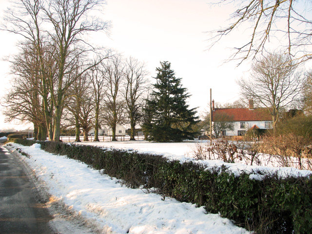
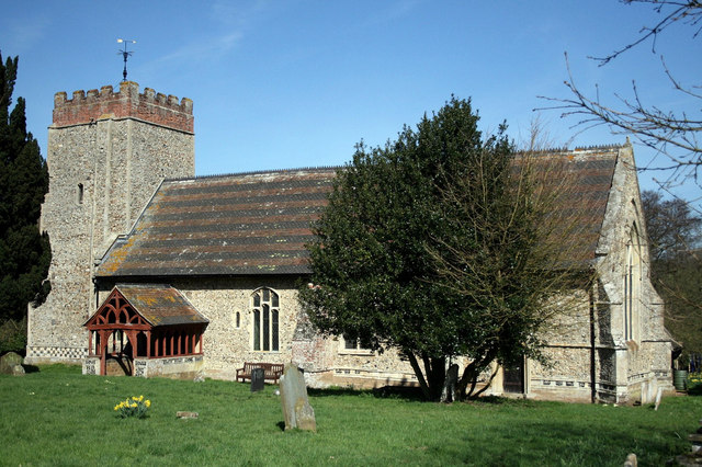
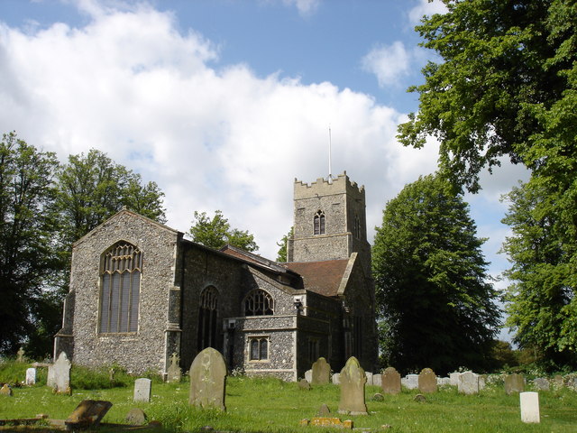
Washbrook Images

Images are sourced within 2km of 52.036596/1.0852994 or Grid Reference TM1142. Thanks to Geograph Open Source API. All images are credited.

Pasture gate by Coles Green Farm
Snowy field by Coles Green Farm
Snowy scenery east of Chattisham
Coles Green Farmhouse in the snow
Farmhouse at Coles Green Farm
A14 eastbound at junction 55 for Ipswich
Leaving the A14 westbound at junction 55
A12 southbound nearing junctions 32 and 32a
Pizza Hut on London Road, Ipswich
The A12, Belstead
The A12, Belstead
Roundabout on Hurdle Makers Hill west of Ipswich
Park by Hurdle Makers Hill, Ipswich
Ipswich Veterinary Centre on Scrivener Road
Scrivener Drive from London Road Ipswich
Thorpe's Hill, Hintlesham
The A12, Belstead
The A12, Belstead
Footpath over field to Red House
Show me another place!

Washbrook is located at Grid Ref: TM1142 (Lat: 52.036596, Lng: 1.0852994)

Administrative County: Suffolk

District: Babergh

Police Authority: Suffolk

What 3 Words

///lookout.reinvest.ferrets. Near Bramford, Suffolk

Nearby Locations

Washbrook

Related Wikis

Washbrook

Washbrook is a village and former civil parish 3 miles (4.8 km) south west of Ipswich, now in the parish of Copdock and Washbrook, in the Babergh district...

Copdock

Copdock is a village and former civil parish, now in the parish of Copdock and Washbrook, in the Babergh district, in the county of Suffolk, England. In...

Old London Road

Old London Road is a cricket ground in Copdock, Suffolk. The first recorded match on the ground was in 1847, when the Gentlemen of Suffolk played the...

St Mary's Church, Washbrook

St Mary's Church is a redundant Anglican church in the village of Washbrook, Suffolk, England. It is recorded in the National Heritage List for England...

Nearby Amenities

Located within 500m of 52.036596,1.0852994
Washbrook
Place: village
Wikidata: Q3248025
Lat/Long: 52.0377362/1.0897946
Bus Stop
Brook Inn
Local Ref: adj
Naptan AtcoCode: 390010541
Naptan Bearing: NE
Naptan CommonName: Brook Inn
Naptan Landmark: Shelter
Naptan NaptanCode: sufagpag
Naptan PlusbusZoneRef: IPSWICH
Naptan Street: The Street
Naptan Verified: no
Public Transport: platform
Source: naptan_import
Lat/Long: 52.0369384/1.0863267
Bus Stop
Brook Inn
Local Ref: opp
Naptan AtcoCode: 390010542
Naptan Bearing: SW
Naptan BusStopType: CUS
Naptan CommonName: Brook Inn
Naptan Landmark: Rear of Bus Sheler
Naptan NaptanCode: sufagpaj
Naptan PlusbusZoneRef: IPSWICH
Naptan Street: Back Lane
Naptan Verified: no
Source: naptan_import
Lat/Long: 52.0369754/1.0862855
Bus Stop
Garage
Local Ref: o/s
Naptan AtcoCode: 390010581
Naptan Bearing: NE
Naptan CommonName: Garage
Naptan Landmark: Garage
Naptan NaptanCode: sufagptw
Naptan PlusbusZoneRef: IPSWICH
Naptan Street: London Road
Naptan Verified: no
Public Transport: platform
Source: naptan_import
Lat/Long: 52.035958/1.0885754
Bus Stop
Garage
Local Ref: opp
Naptan AtcoCode: 390010582
Naptan Bearing: SW
Naptan BusStopType: CUS
Naptan CommonName: Garage
Naptan Landmark: Garage
Naptan NaptanCode: sufagpwa
Naptan PlusbusZoneRef: IPSWICH
Naptan Street: London Road
Naptan Verified: no
Public Transport: platform
Source: naptan_import
Lat/Long: 52.0356285/1.0885445
Bus Stop
London Road
Local Ref: adj
Naptan AtcoCode: 390010583
Naptan Bearing: NW
Naptan CommonName: London Road
Naptan Landmark: London Road
Naptan NaptanCode: sufagpwd
Naptan PlusbusZoneRef: IPSWICH
Naptan Street: Chapel Lane
Naptan Verified: no
Public Transport: platform
Source: naptan_import
Lat/Long: 52.0384399/1.0904553
Bus Stop
London Road
Local Ref: opp
Naptan AtcoCode: 390010584
Naptan Bearing: SE
Naptan BusStopType: CUS
Naptan CommonName: London Road
Naptan Landmark: London Road
Naptan NaptanCode: sufagpwg
Naptan PlusbusZoneRef: IPSWICH
Naptan Street: Chapel Lane
Naptan Verified: no
Public Transport: platform
Source: naptan_import
Lat/Long: 52.0383256/1.0911232
Bus Stop
Brook Inn
Local Ref: O/S
Naptan AtcoCode: 390010821
Naptan Bearing: NW
Naptan BusStopType: CUS
Naptan CommonName: Brook Inn
Naptan Landmark: Brook Inn
Naptan NaptanCode: sufjmwtp
Naptan PlusbusZoneRef: IPSWICH
Naptan Street: Back Lane
Naptan Verified: no
Source: naptan_import
Lat/Long: 52.0370296/1.0862946
Power: pole
Lat/Long: 52.0354605/1.0922278
Power: pole
Lat/Long: 52.0362888/1.0918764
Power: pole
Lat/Long: 52.0370147/1.0916109
Power: pole
Lat/Long: 52.0374553/1.0914151
Power: pole
Lat/Long: 52.0380674/1.0902591
Give Way
Lat/Long: 52.0379895/1.0919039
Turning Circle
Lat/Long: 52.0391087/1.0904266
Defibrillator
Defibrillator Location: On the western end of the Brook Inn.
Emergency: defibrillator
Indoor: no
Ref: CHT-9637
Lat/Long: 52.0369363/1.0858447
Turning Circle
Lat/Long: 52.0391218/1.090613
Public Bookcase
Booth: K6
Disused Amenity: telephone
Man Made: telephone_box
Public Bookcase Type: phone_box
Lat/Long: 52.0384242/1.0886923
Give Way
Lat/Long: 52.0380215/1.0916421
Addr City: Copdock
Addr Housenumber: 23A
Addr Postcode: IP8 3LG
Addr Street: Pearsons Way
Lat/Long: 52.0368603/1.0883905
Addr City: Copdock
Addr Housenumber: 23B
Addr Postcode: IP8 3LG
Addr Street: Pearsons Way
Lat/Long: 52.0367995/1.0883331
Give Way
Direction: backward
Lat/Long: 52.0369111/1.0861445
Give Way
Direction: forward
Lat/Long: 52.0368352/1.086244
Give Way
Direction: backward
Lat/Long: 52.0370392/1.0865253
Addr City: Washbrook
Addr Housename: Brook Cottage
Addr Postcode: IP8 3HR
Addr Street: The Street
Lat/Long: 52.0370841/1.0863054
Addr City: Washbrook
Addr Housename: 1 Chestnut Cottages
Addr Postcode: IP8 3HR
Addr Street: The Street
Lat/Long: 52.0370495/1.0862208
Addr City: Washbrook
Addr Housename: 2 Chestnut Cottages
Addr Postcode: IP8 3HR
Addr Street: The Street
Lat/Long: 52.037023/1.0861491
Addr City: Washbrook
Addr Housename: High View
Addr Postcode: IP8 3JA
Addr Street: Back Lane
Lat/Long: 52.0358309/1.0841824
Addr City: Washbrook
Addr Housename: Gainsborough Cottage
Addr Postcode: IP8 3JA
Addr Street: Back Lane
Lat/Long: 52.0358466/1.0840121
Addr City: Washbrook
Addr Housename: Chelmesis
Addr Postcode: IP8 3JA
Addr Street: Back Lane
Lat/Long: 52.035788/1.0839316
Addr City: Washbrook
Addr Housename: Inglenook
Addr Postcode: IP8 3JA
Addr Street: Back Lane
Lat/Long: 52.0358714/1.0838176
Addr City: Washbrook
Addr Housename: Cherry Cottage
Addr Postcode: IP8 3JA
Addr Street: Back Lane
Lat/Long: 52.035774/1.0836446
Addr City: Washbrook
Addr Housename: Cherry Orchard
Addr Postcode: IP8 3JA
Addr Street: Back Lane
Lat/Long: 52.0358557/1.0834502
Addr City: Washbrook
Addr Housename: 2 Swan Farm House
Addr Postcode: IP8 3LH
Lat/Long: 52.0390958/1.089696
Addr City: Washbrook
Addr Housename: 1 Swan Farm House
Addr Postcode: IP8 3LH
Lat/Long: 52.0392028/1.0895559
Noexit: yes
Lat/Long: 52.0372169/1.0854362
Post Box
Operator: Royal Mail
Post Box Mounting: pier
Post Box Type: lamp
Ref: IP8 1203
Lat/Long: 52.0371796/1.0870963
The data included in this document is from www.openstreetmap.org. The data is made available under ODbL.

Have you been to Washbrook?

Leave your review of Washbrook below (or comments, questions and feedback).