Warwick Bridge

Settlement in Cumberland Carlisle

England

Warwick Bridge

"Newby East"
"Newby East" Credit: John Holmes

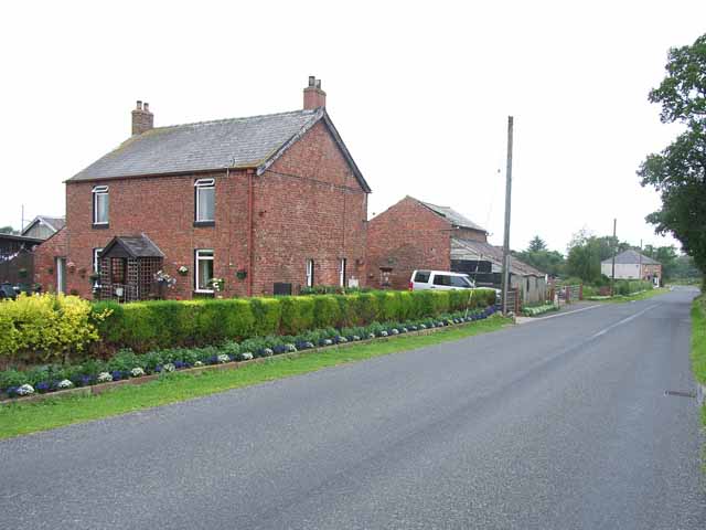
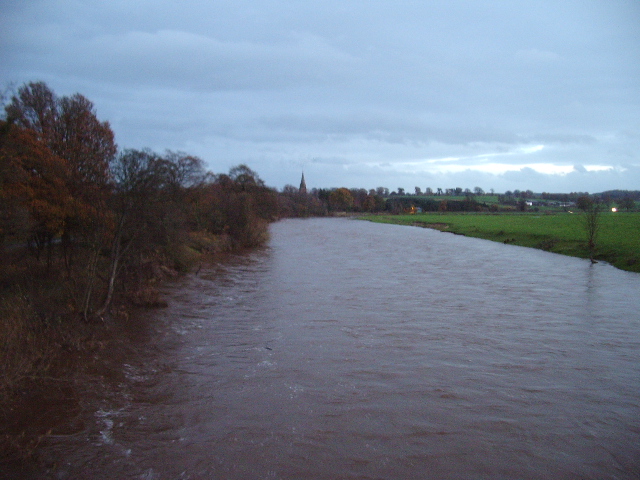
Warwick Bridge is a small village located in the county of Cumberland, in the northwestern region of England. Situated on the banks of the River Eden, it lies approximately 3 miles southeast of Carlisle, the county town. The village is nestled amidst picturesque countryside, with rolling hills and lush green fields surrounding the area.

The village is best known for its historic bridge, from which it takes its name. Warwick Bridge is a charming stone structure that spans the River Eden and has been an important crossing point for centuries. Originally built in the 14th century, the bridge has undergone several renovations and repairs over the years but still retains its original character and charm.

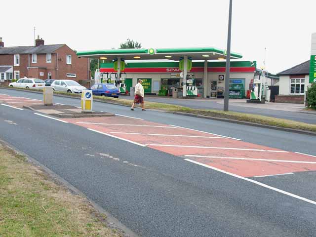
In addition to its iconic bridge, Warwick Bridge is also home to a handful of residential properties, a local pub, and a small convenience store. The village offers a peaceful and idyllic setting, with its tranquil atmosphere attracting both locals and tourists alike.

The surrounding area provides ample opportunities for outdoor activities, such as walking, cycling, and fishing. The nearby River Eden is renowned for its salmon and trout, making it a popular destination for anglers. Additionally, the village's proximity to Carlisle offers residents easy access to a wider range of amenities and services.

Overall, Warwick Bridge is a quaint and picturesque village that embodies the beauty and tranquility of the English countryside. Its historic bridge and charming surroundings make it a delightful destination for visitors seeking a peaceful retreat.

If you have any feedback on the listing, please let us know in the comments section below.

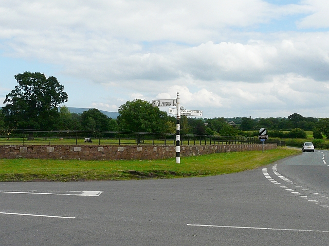
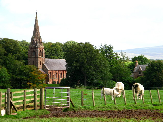
Warwick Bridge Images

Images are sourced within 2km of 54.904009/-2.8178746 or Grid Reference NY4756. Thanks to Geograph Open Source API. All images are credited.

"Newby East"
"Newby East"
Livestock sheds at Holme Ends Farm, Newby East Not too sure what's being kept in these sheds. Chickens?
Livestock sheds at Holme Ends Farm, Newby East
Not too sure what's being kept in these sheds. Chickens?
A69, Warwick Bridge The village of Warwick Bridge is bisected by the very busy A69 Carlisle to Newcastle road
A69, Warwick Bridge
The village of Warwick Bridge is bisected by the very busy A69 Carlisle to Newcastle road
Spar shop and filling station, Warwick Bridge As is so often found now, the filling station on the busy A69 doubles up as the village shop.
Spar shop and filling station, Warwick Bridge
As is so often found now, the filling station on the busy A69 doubles up as the village shop.
Traffic lights, Corby Hill Where the road from Little Corby to Heads Nook crosses the busy A69 Carlisle to Newcastle road
Traffic lights, Corby Hill
Where the road from Little Corby to Heads Nook crosses the busy A69 Carlisle to Newcastle road
Little Corby The white house on the left is the Haywain public house
Little Corby
The white house on the left is the Haywain public house
River Irthing Looking upstream from the bridge at Newby East
River Irthing
Looking upstream from the bridge at Newby East
Newby East from the bridge The village stands well above the river on a terrace. The building on the left looks very much like a fortified farmhouse, quite common in Cumbria, dating from the days of the Border Reivers.
Newby East from the bridge
The village stands well above the river on a terrace. The building on the left looks very much like a fortified farmhouse, quite common in Cumbria, dating from the days of the Border Reivers.
Signpost near Heads Nook There are many "heritage" signposts still standing in Cumbria.
Signpost near Heads Nook
There are many "heritage" signposts still standing in Cumbria.
Applegarth Farm near Warwick Bridge Allengrove House in the distance
Applegarth Farm near Warwick Bridge
Allengrove House in the distance
Parkland at Corby Hill, Warwick Bridge
The Coach House, Heads Nook A large country pub, licensed for weddings. Also the venue for the Carlisle Folk and Blues Club.
The Coach House, Heads Nook
A large country pub, licensed for weddings. Also the venue for the Carlisle Folk and Blues Club.
Ashview, near Heads Nook With adjoining cottage. Ashview is the white house.
Ashview, near Heads Nook
With adjoining cottage. Ashview is the white house.
Warwick Bridge Carries the A69 Carlisle to Newcastle road over the River Eden, between Warwick Bridge and Warwick-on-Eden
Warwick Bridge
Carries the A69 Carlisle to Newcastle road over the River Eden, between Warwick Bridge and Warwick-on-Eden
Warwick Bridge Up-stream side of Warwick Bridge
Warwick Bridge
Up-stream side of Warwick Bridge
River Eden Looking down stream from Warwick Bridge, in the distance is Warwick Hall
River Eden
Looking down stream from Warwick Bridge, in the distance is Warwick Hall
River Eden Looking up stream from Warwick Bridge, the church in the distance is St Paul Church, Holme Eden
River Eden
Looking up stream from Warwick Bridge, the church in the distance is St Paul Church, Holme Eden
The Road to Myre Bank
Show me another place!

Warwick Bridge is located at Grid Ref: NY4756 (Lat: 54.904009, Lng: -2.8178746)

Administrative County: Cumbria

District: Carlisle

Police Authority: Cumbria

What 3 Words

///implanted.unusually.similar. Near Wetheral, Cumbria

Nearby Locations

Warwick Bridge

Related Wikis

Warwick Bridge

Warwick Bridge is a village in the Cumberland area of the county of Cumbria, England. It forms part of a small urban area which includes the villages of...

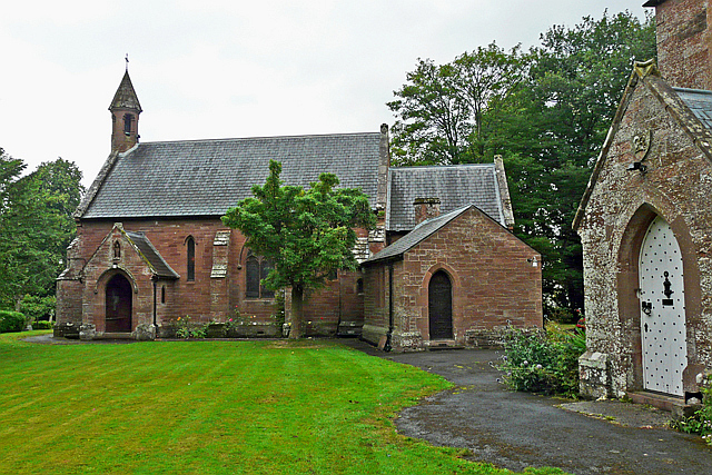
Our Lady and St Wilfrid's Church, Warwick Bridge

Our Lady and St Wilfrid's Church is a Roman Catholic church designed by Augustus Welby Northmore Pugin, completed in 1841. The church was designed for...

Little Corby

Little Corby is a village in the county of Cumbria in the north of England. It is east of the city of Carlisle, alongside the River Eden and near to the...

Corby Hill

Corby Hill is a village in Cumbria, England. It is located 5.4 miles (8.7 km) by road east of the city centre of Carlisle. The Trout Beck stream passes...

Holme Eden Abbey

Holme Eden Abbey was an abbey in Cumbria, England. The current building (built 1833–37) is a Grade II* listed building. == History == It was designed in...

Warwick Hall

Warwick Hall is a large country house located on the banks of the River Eden at Warwick-on-Eden in Cumbria, England, United Kingdom. == History == The...

Warwick-on-Eden

Warwick-on-Eden is a small village and (as just Warwick) a former civil parish, now in the parish of Wetheral, in the Carlisle district of the county of...

Burnrigg

Burnrigg is a hamlet in Cumbria, England. It is located to the east of Carlisle. In 1887, The British Architect said "on a site particularly high and open...

Nearby Amenities

Located within 500m of 54.904009,-2.8178746
Crossing
Crossing: island
Kerb: lowered
Tactile Paving: yes
Lat/Long: 54.9047948/-2.8150543
Traffic Signals
Lat/Long: 54.9058641/-2.8138285
Warwick Bridge
Place: village
Source: NPE
Wikidata: Q2212919
Lat/Long: 54.9041669/-2.8188408
Little Corby
Place: village
Source: NPE
Wikidata: Q6649643
Lat/Long: 54.9079408/-2.8174928
Speed Camera
Lat/Long: 54.9044227/-2.8163673
Bus Stop
Crossroads (W bound)
Bench: no
Bus: yes
Departures Board: timetable
Naptan AtcoCode: 090033192133
Naptan Bearing: W
Naptan CommonName: Crossroads (W bound)
Naptan Indicator: opp
Naptan Landmark: Wingate Cottage
Naptan NaptanCode: cumapwma
Naptan Street: A69
Naptan Verified: no
Public Transport: platform
Shelter: yes
Source: naptan_import
Lat/Long: 54.9061969/-2.8131733
Bus Stop
Crossroads (E bound)
Bench: no
Bus: yes
Naptan AtcoCode: 090033192888
Naptan Bearing: E
Naptan CommonName: Crossroads (E bound)
Naptan Indicator: o/s
Naptan Landmark: Wingate Cottage
Naptan NaptanCode: cumapwpa
Naptan Street: A69
Naptan Verified: no
Passenger Information Display: no
Public Transport: platform
Source: naptan_import
Lat/Long: 54.9062508/-2.8133575
Bus Stop
Warwick Bridge School
Bus: yes
Naptan AtcoCode: 090033441813
Naptan Bearing: W
Naptan CommonName: Warwick Bridge School
Naptan Indicator: o/s
Naptan Landmark: Warwick Bridge School
Naptan NaptanCode: cumatgpw
Naptan Street: A69
Naptan Verified: no
Public Transport: platform
Shelter: yes
Source: naptan_import
Lat/Long: 54.9030711/-2.8237893
Bus Stop
The George PH
Naptan AtcoCode: 090033442824
Naptan Bearing: W
Naptan CommonName: The George PH
Naptan Indicator: o/s
Naptan Landmark: The George Pub
Naptan NaptanCode: cumatjdw
Naptan Street: A69
Naptan Verified: no
Source: naptan_import
Lat/Long: 54.9038556/-2.818066
Bus Stop
Little Corby Road
Local Ref: AT
Naptan AtcoCode: 090033443649
Naptan Bearing: E
Naptan CommonName: Little Corby Road
Naptan Indicator: at
Naptan Landmark: junction with Little Corby Road
Naptan NaptanCode: cumatjpg
Naptan Street: A69
Naptan Verified: no
Source: naptan_import
Lat/Long: 54.9039975/-2.8223421
Turning Circle
Lat/Long: 54.90612/-2.8166791
Turning Circle
Lat/Long: 54.9066134/-2.8180685
Turning Circle
Lat/Long: 54.9049141/-2.8160997
Turning Circle
Lat/Long: 54.9051472/-2.8176
Turning Circle
Lat/Long: 54.9057375/-2.8167928
Turning Circle
Lat/Long: 54.904837/-2.8195705
Turning Circle
Lat/Long: 54.9071747/-2.8141632
Turning Circle
Lat/Long: 54.9067275/-2.8132995
Turning Circle
Lat/Long: 54.9070976/-2.8124305
Turning Circle
Lat/Long: 54.9074893/-2.8148069
Turning Circle
Lat/Long: 54.9025301/-2.8229602
Cycleway: asl
Lat/Long: 54.9057806/-2.8136448
Corby Hill
Place: village
Wikidata: Q5169819
Lat/Long: 54.9055652/-2.8137982
Post Office
Corby Hill Post Office
Addr City: Carlisle
Addr Country: GB
Addr Place: Corby Hill Garage
Addr Postcode: CA4 8PL
Brand: Post Office
Brand Wikidata: Q1783168
Check Date: 2022-05-27
Contact Website: https://www.postoffice.co.uk/branch-finder/471458x/corby-hill
Ref Pol Id: 124693
Lat/Long: 54.9048274/-2.8143773
Crossing
Crossing: island
Lat/Long: 54.9041481/-2.8175448
Post Box
Drive Through: no
Operator: Royal Mail
Operator Wikidata: Q638098
Post Box Design: type_l
Post Box Type: lamp
Ref: CA4 148
Royal Cypher: EIIR
Royal Cypher Wikidata: Q33102113
Lat/Long: 54.9038286/-2.8174341
Telephone
Booth: KX100
Covered: booth
Lat/Long: 54.9045674/-2.8152543
Bench
Lat/Long: 54.905845/-2.8141287
Bench
Lat/Long: 54.9057936/-2.814147
Waste Basket
Lat/Long: 54.9058334/-2.8141409
Turning Circle
Lat/Long: 54.9050171/-2.8210934
Post Box
Ref: CA4 44
Lat/Long: 54.9049266/-2.8207168
Post Box
Ref: CA4 3
Lat/Long: 54.9062942/-2.8146042
Bus Stop
Bench: yes
Bus: yes
Public Transport: platform
Shelter: yes
Lat/Long: 54.9043444/-2.8171428
Give Way
Direction: backward
Lat/Long: 54.9046288/-2.8153125
Milestone
Lat/Long: 54.9052428/-2.8145669
Board Type: notice
Information: board
Tourism: information
Lat/Long: 54.9059098/-2.8140714
Crossing
Crossing: traffic_signals
Kerb: lowered
Tactile Paving: yes
Lat/Long: 54.9057331/-2.8139535
Bus Stop
Bench: yes
Bin: yes
Bus: yes
Public Transport: platform
Shelter: yes
Lat/Long: 54.9042928/-2.8167332
Cafe
Sally's Cafe
Addr City: Warwick Bridge
Addr Postcode: CA4 8RN
Phone: +44 1228 317071
Website: https://www.sallyswarwickbridge.co.uk/
Wheelchair: yes
Lat/Long: 54.9038645/-2.817356
Co-op Food
Addr City: Warwick Bridge
Addr Postcode: CA4 8SA
Brand: Co-op Food
Brand Wikidata: Q3277439
Brand Wikipedia: en:Co-op Food
Operator: The Co-operative Group
Operator Wikidata: Q117202
Phone: +44 1228 562863
Shop: supermarket
Website: https://www.coop.co.uk/store-finder/CA4-8SA/king-george-court
Wheelchair: yes
Lat/Long: 54.9036987/-2.8177842
Atm
Lat/Long: 54.9038178/-2.8177337
Troutbeck Cottage
Addr City: Warwick Bridge
Addr Postcode: CA4 8RN
Tourism: guest_house
Lat/Long: 54.9040331/-2.817168
Steve Wilson
Addr City: Corby Hill
Addr Postcode: CA4 8QG
Phone: +44 1228 560896
Shop: butcher
Website: https://steven-wilson-butchers.business.site/
Lat/Long: 54.9065761/-2.8160348
Addr Housename: Langley Toll Cottage
Lat/Long: 54.9058708/-2.8136092
Power: substation
Lat/Long: 54.9060601/-2.8133613
Power: pole
Lat/Long: 54.9064028/-2.811316
Power: pole
Lat/Long: 54.9003848/-2.8146535
Power: pole
Lat/Long: 54.9026202/-2.8184299
Power: pole
Lat/Long: 54.9032773/-2.8184143
Power: pole
Lat/Long: 54.9019003/-2.8184477
Power: pole
Lat/Long: 54.9015262/-2.8193456
Power: pole
Lat/Long: 54.9007755/-2.8210522
The data included in this document is from www.openstreetmap.org. The data is made available under ODbL.

Have you been to Warwick Bridge?

Leave your review of Warwick Bridge below (or comments, questions and feedback).