Waddon

Settlement in Devon Teignbridge

England

Waddon

Layby on the A38 near Chudleigh The A38 is a major A-class trunk route. When first designated in 1922, it ran from Derby to Plymouth but it was later extended at both ends so that it now runs for 292 miles from Mansfield in Nottinghamshire to Bodmin in Cornwall.

Prior to the opening of the M5 motorway in the 1960s and 1970s, the A38 formed the main "holiday route" from the Midlands to Somerset, Devon and Cornwall and the south-western section was notorious at holiday times for the congestion. Nowadays, for most of the southern section, the A38 is a fairly quiet road shadowing the M5 extremely closely; often running alongside the motorway as a single carriageway road. The section between Exeter and Plymouth is, however, a busy dual carriageway which serves as the southern extension of the M5 and is known as “the Devon Expressway”.

More information at <span class="nowrap"><a title="http://en.wikipedia.org/wiki/A38_road" rel="nofollow ugc noopener" href="http://en.wikipedia.org/wiki/A38_road">Link</a><img style="margin-left:2px;" alt="External link" title="External link - shift click to open in new window" src="https://s1.geograph.org.uk/img/external.png" width="10" height="10"/></span>  (Wikipedia) and <span class="nowrap"><a title="http://www.sabre-roads.org.uk/wiki/index.php?title=A38" rel="nofollow ugc noopener" href="http://www.sabre-roads.org.uk/wiki/index.php?title=A38">Link</a><img style="margin-left:2px;" alt="External link" title="External link - shift click to open in new window" src="https://s1.geograph.org.uk/img/external.png" width="10" height="10"/></span>  (SABRE).
Layby on the A38 near Chudleigh Credit: David Dixon

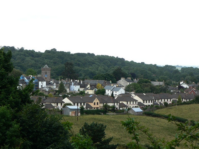
Waddon is a small village located in the county of Devon, in southwestern England. Situated in the Teignbridge district, Waddon is nestled in the picturesque countryside, surrounded by rolling hills and lush green fields. The village is home to a population of around 300 residents and is known for its peaceful and tranquil atmosphere.

Waddon is characterized by its charming thatched cottages and traditional stone buildings, which give the village a quaint and old-worldly feel. The architecture in Waddon reflects the area's rich history, with some buildings dating back several centuries.

Despite its small size, Waddon offers a range of amenities to its residents and visitors. There is a local pub, serving up traditional English fare and ales, as well as a small village shop for daily essentials. The village also has a primary school, providing education for local children.

Surrounded by beautiful countryside, Waddon offers plenty of opportunities for outdoor activities. The area is known for its scenic walking and cycling routes, allowing residents and visitors to explore the stunning landscapes and enjoy the fresh country air.

Waddon is conveniently located near the larger towns of Newton Abbot and Exeter, providing access to a wider range of amenities and services. Overall, Waddon is a charming and idyllic village, offering a peaceful retreat for those seeking a slower pace of life in the heart of the Devonshire countryside.

If you have any feedback on the listing, please let us know in the comments section below.

Waddon Images

Images are sourced within 2km of 50.599942/-3.5839157 or Grid Reference SX8879. Thanks to Geograph Open Source API. All images are credited.

Layby on the A38 near Chudleigh The A38 is a major A-class trunk route. When first designated in 1922, it ran from Derby to Plymouth but it was later extended at both ends so that it now runs for 292 miles from Mansfield in Nottinghamshire to Bodmin in Cornwall.

Prior to the opening of the M5 motorway in the 1960s and 1970s, the A38 formed the main "holiday route" from the Midlands to Somerset, Devon and Cornwall and the south-western section was notorious at holiday times for the congestion. Nowadays, for most of the southern section, the A38 is a fairly quiet road shadowing the M5 extremely closely; often running alongside the motorway as a single carriageway road. The section between Exeter and Plymouth is, however, a busy dual carriageway which serves as the southern extension of the M5 and is known as “the Devon Expressway”.

More information at <span class="nowrap"><a title="http://en.wikipedia.org/wiki/A38_road" rel="nofollow ugc noopener" href="http://en.wikipedia.org/wiki/A38_road">Link</a><img style="margin-left:2px;" alt="External link" title="External link - shift click to open in new window" src="https://s1.geograph.org.uk/img/external.png" width="10" height="10"/></span>  (Wikipedia) and <span class="nowrap"><a title="http://www.sabre-roads.org.uk/wiki/index.php?title=A38" rel="nofollow ugc noopener" href="http://www.sabre-roads.org.uk/wiki/index.php?title=A38">Link</a><img style="margin-left:2px;" alt="External link" title="External link - shift click to open in new window" src="https://s1.geograph.org.uk/img/external.png" width="10" height="10"/></span>  (SABRE).
Layby on the A38 near Chudleigh
The A38 is a major A-class trunk route. When first designated in 1922, it ran from Derby to Plymouth but it was later extended at both ends so that it now runs for 292 miles from Mansfield in Nottinghamshire to Bodmin in Cornwall. Prior to the opening of the M5 motorway in the 1960s and 1970s, the A38 formed the main "holiday route" from the Midlands to Somerset, Devon and Cornwall and the south-western section was notorious at holiday times for the congestion. Nowadays, for most of the southern section, the A38 is a fairly quiet road shadowing the M5 extremely closely; often running alongside the motorway as a single carriageway road. The section between Exeter and Plymouth is, however, a busy dual carriageway which serves as the southern extension of the M5 and is known as “the Devon Expressway”. More information at LinkExternal link (Wikipedia) and LinkExternal link (SABRE).
Bridge over the Devon Expressway near Chudleigh The A38 is a major A-class trunk route. When first designated in 1922, it ran from Derby to Plymouth but it was later extended at both ends so that it now runs for 292 miles from Mansfield in Nottinghamshire to Bodmin in Cornwall.

Prior to the opening of the M5 motorway in the 1960s and 1970s, the A38 formed the main "holiday route" from the Midlands to Somerset, Devon and Cornwall and the south-western section was notorious at holiday times for the congestion. Nowadays, for most of the southern section, the A38 is a fairly quiet road shadowing the M5 extremely closely; often running alongside the motorway as a single carriageway road. The section between Exeter and Plymouth is, however, a busy dual carriageway which serves as the southern extension of the M5 and is known as “the Devon Expressway”.

More information at <span class="nowrap"><a title="http://en.wikipedia.org/wiki/A38_road" rel="nofollow ugc noopener" href="http://en.wikipedia.org/wiki/A38_road">Link</a><img style="margin-left:2px;" alt="External link" title="External link - shift click to open in new window" src="https://s1.geograph.org.uk/img/external.png" width="10" height="10"/></span>  (Wikipedia) and <span class="nowrap"><a title="http://www.sabre-roads.org.uk/wiki/index.php?title=A38" rel="nofollow ugc noopener" href="http://www.sabre-roads.org.uk/wiki/index.php?title=A38">Link</a><img style="margin-left:2px;" alt="External link" title="External link - shift click to open in new window" src="https://s1.geograph.org.uk/img/external.png" width="10" height="10"/></span>  (SABRE).
Bridge over the Devon Expressway near Chudleigh
The A38 is a major A-class trunk route. When first designated in 1922, it ran from Derby to Plymouth but it was later extended at both ends so that it now runs for 292 miles from Mansfield in Nottinghamshire to Bodmin in Cornwall. Prior to the opening of the M5 motorway in the 1960s and 1970s, the A38 formed the main "holiday route" from the Midlands to Somerset, Devon and Cornwall and the south-western section was notorious at holiday times for the congestion. Nowadays, for most of the southern section, the A38 is a fairly quiet road shadowing the M5 extremely closely; often running alongside the motorway as a single carriageway road. The section between Exeter and Plymouth is, however, a busy dual carriageway which serves as the southern extension of the M5 and is known as “the Devon Expressway”. More information at LinkExternal link (Wikipedia) and LinkExternal link (SABRE).
Bridge over the A38 near Chudleigh The A38 is a major A-class trunk route. When first designated in 1922, it ran from Derby to Plymouth but it was later extended at both ends so that it now runs for 292 miles from Mansfield in Nottinghamshire to Bodmin in Cornwall.

Prior to the opening of the M5 motorway in the 1960s and 1970s, the A38 formed the main "holiday route" from the Midlands to Somerset, Devon and Cornwall and the south-western section was notorious at holiday times for the congestion. Nowadays, for most of the southern section, the A38 is a fairly quiet road shadowing the M5 extremely closely; often running alongside the motorway as a single carriageway road. The section between Exeter and Plymouth is, however, a busy dual carriageway which serves as the southern extension of the M5 and is known as “the Devon Expressway”.

More information at <span class="nowrap"><a title="http://en.wikipedia.org/wiki/A38_road" rel="nofollow ugc noopener" href="http://en.wikipedia.org/wiki/A38_road">Link</a><img style="margin-left:2px;" alt="External link" title="External link - shift click to open in new window" src="https://s1.geograph.org.uk/img/external.png" width="10" height="10"/></span>  (Wikipedia) and <span class="nowrap"><a title="http://www.sabre-roads.org.uk/wiki/index.php?title=A38" rel="nofollow ugc noopener" href="http://www.sabre-roads.org.uk/wiki/index.php?title=A38">Link</a><img style="margin-left:2px;" alt="External link" title="External link - shift click to open in new window" src="https://s1.geograph.org.uk/img/external.png" width="10" height="10"/></span>  (SABRE).
Bridge over the A38 near Chudleigh
The A38 is a major A-class trunk route. When first designated in 1922, it ran from Derby to Plymouth but it was later extended at both ends so that it now runs for 292 miles from Mansfield in Nottinghamshire to Bodmin in Cornwall. Prior to the opening of the M5 motorway in the 1960s and 1970s, the A38 formed the main "holiday route" from the Midlands to Somerset, Devon and Cornwall and the south-western section was notorious at holiday times for the congestion. Nowadays, for most of the southern section, the A38 is a fairly quiet road shadowing the M5 extremely closely; often running alongside the motorway as a single carriageway road. The section between Exeter and Plymouth is, however, a busy dual carriageway which serves as the southern extension of the M5 and is known as “the Devon Expressway”. More information at LinkExternal link (Wikipedia) and LinkExternal link (SABRE).
Old Milestone by UC road (was A38), New Exeter Road, by Oakfields The Milestone is located in a hedge by the road.  Parish of Chudleigh (Teignbridge District). Carved stone post, Exeter tombstone design, erected by the Exeter turnpike trust in the 19th Century, missing in 2005. An earlier photograph can be found here: <span class="nowrap"><a title="http://www.flickr.com/photos/bridgemarkertim/5123846159" rel="nofollow ugc noopener" href="http://www.flickr.com/photos/bridgemarkertim/5123846159">Link</a><img style="margin-left:2px;" alt="External link" title="External link - shift click to open in new window" src="https://s1.geograph.org.uk/img/external.png" width="10" height="10"/></span> 

Inscription reads:-  
9 / MILES / TO / EXETER  

Milestone Society National ID: DV_EXCH09
Old Milestone by UC road (was A38), New Exeter Road, by Oakfields
The Milestone is located in a hedge by the road.  Parish of Chudleigh (Teignbridge District). Carved stone post, Exeter tombstone design, erected by the Exeter turnpike trust in the 19th Century, missing in 2005. An earlier photograph can be found here: LinkExternal link  Inscription reads:- 9 / MILES / TO / EXETER Milestone Society National ID: DV_EXCH09
Woodway Street bridge over A38 north of Chudleigh The design of the bridge is very similar to <a href="https://www.geograph.org.uk/photo/2372098">SX8780 : Heathfieldlake Hill bridge crossing A38 north-east of Chudleigh</a> which is about 1km to the east.
Woodway Street bridge over A38 north of Chudleigh
The design of the bridge is very similar to SX8780 : Heathfieldlake Hill bridge crossing A38 north-east of Chudleigh which is about 1km to the east.
Heathfieldlake Hill bridge crossing A38 north-east of Chudleigh The design of the bridge is very similar to <a href="https://www.geograph.org.uk/photo/2372089">SX8680 : Woodway Street bridge over A38 north of Chudleigh</a> which is about 1km to the west.
Heathfieldlake Hill bridge crossing A38 north-east of Chudleigh
The design of the bridge is very similar to SX8680 : Woodway Street bridge over A38 north of Chudleigh which is about 1km to the west.
Layby on A38 near Filleigh
Bridge carrying Old Exeter Road over A38
A38 in cutting north of Filleigh
Bottle Bridge According to: <span class="nowrap"><a title="http://www.chudleighhistorygroup.com/toll-houses.html" rel="nofollow ugc noopener" href="http://www.chudleighhistorygroup.com/toll-houses.html">Link</a><img style="margin-left:2px;" alt="External link" title="External link - shift click to open in new window" src="https://s1.geograph.org.uk/img/external.png" width="10" height="10"/></span> , the name "Bottle" may be a corruption of "Buddle", and two origins are suggested for this.  The site prefers "a meaning of buddle as being a spring of water bursting through the road"
Bottle Bridge
According to: LinkExternal link , the name "Bottle" may be a corruption of "Buddle", and two origins are suggested for this. The site prefers "a meaning of buddle as being a spring of water bursting through the road"
Orange Way in Devon and Torbay (160) The Way carries on up Heathfieldlake Hill seen here from Bottle Bridge.
Orange Way in Devon and Torbay (160)
The Way carries on up Heathfieldlake Hill seen here from Bottle Bridge.
Orange Way in Devon and Torbay (161) Here is a field entrance passed on Heathfieldlake Hill.
Orange Way in Devon and Torbay (161)
Here is a field entrance passed on Heathfieldlake Hill.
Orange Way in Devon and Torbay (162) "The Convent" on Heathfieldlake Hill is now a private residence.
Orange Way in Devon and Torbay (162)
"The Convent" on Heathfieldlake Hill is now a private residence.
Orange Way in Devon and Torbay (163) The minor road crosses the A38 here.
Orange Way in Devon and Torbay (163)
The minor road crosses the A38 here.
Woodway Street Bridge, A38 The A38 is also known as the Devon Expressway. It runs 292 miles from Bodmin to Mansfield, across the South West and Midlands. Primary places visited include Liskeard, Plymouth, Exeter, Taunton, Bridgwater, Bristol, Gloucester, Worcester, Bromsgrove, Birmingham, Lichfield, Burton upon Trent and Derby.
Wikipedia: <span class="nowrap"><a title="http://en.wikipedia.org/wiki/A38_road" rel="nofollow ugc noopener" href="http://en.wikipedia.org/wiki/A38_road">Link</a><img style="margin-left:2px;" alt="External link" title="External link - shift click to open in new window" src="https://s1.geograph.org.uk/img/external.png" width="10" height="10"/></span>
Woodway Street Bridge, A38
The A38 is also known as the Devon Expressway. It runs 292 miles from Bodmin to Mansfield, across the South West and Midlands. Primary places visited include Liskeard, Plymouth, Exeter, Taunton, Bridgwater, Bristol, Gloucester, Worcester, Bromsgrove, Birmingham, Lichfield, Burton upon Trent and Derby. Wikipedia: LinkExternal link
Heathfield Lake Hill Bridge, A38 The A38 is also known as the Devon Expressway. It runs 292 miles from Bodmin to Mansfield, across the South West and Midlands. Primary places visited include Liskeard, Plymouth, Exeter, Taunton, Bridgwater, Bristol, Gloucester, Worcester, Bromsgrove, Birmingham, Lichfield, Burton upon Trent and Derby.
Wikipedia: <span class="nowrap"><a title="http://en.wikipedia.org/wiki/A38_road" rel="nofollow ugc noopener" href="http://en.wikipedia.org/wiki/A38_road">Link</a><img style="margin-left:2px;" alt="External link" title="External link - shift click to open in new window" src="https://s1.geograph.org.uk/img/external.png" width="10" height="10"/></span>
Heathfield Lake Hill Bridge, A38
The A38 is also known as the Devon Expressway. It runs 292 miles from Bodmin to Mansfield, across the South West and Midlands. Primary places visited include Liskeard, Plymouth, Exeter, Taunton, Bridgwater, Bristol, Gloucester, Worcester, Bromsgrove, Birmingham, Lichfield, Burton upon Trent and Derby. Wikipedia: LinkExternal link
Farm entrance on minor road north of Chudleigh
Bridge over A38 north of Chudleigh
Show me another place!

Waddon is located at Grid Ref: SX8879 (Lat: 50.599942, Lng: -3.5839157)

Administrative County: Devon

District: Teignbridge

Police Authority: Devon and Cornwall

What 3 Words

///blemishes.tree.admires. Near Chudleigh, Devon

Nearby Locations

Burrows Wood Waddon

Related Wikis

Ugbrooke

Ugbrooke House is a stately home in the parish of Chudleigh, Devon, England, situated in a valley between Exeter and Newton Abbot. The home of the Clifford...

Chudleigh Town Hall

Chudleigh Town Hall is a municipal building in Market Way, Chudleigh, Devon, England. The town hall, which is the meeting place of Chudleigh Town Council...

Chudleigh

Chudleigh () is an ancient wool town located within the Teignbridge District Council area of Devon, England between Newton Abbot and Exeter. The electoral...

Chudleigh Cavern

Chudleigh Cavern is a limestone cave outside the town of Chudleigh in Devon, England. The cave is deep and contains stalactites. A small part is open to...

Nearby Amenities

Located within 500m of 50.599942,-3.5839157
Biddlecombe Cross
Place: locality
Source: OS_OpenData_StreetView
Lat/Long: 50.6005061/-3.5836415
Biddlecombe
Building: yes
Lat/Long: 50.5990653/-3.5841068
The data included in this document is from www.openstreetmap.org. The data is made available under ODbL.

Have you been to Waddon?

Leave your review of Waddon below (or comments, questions and feedback).