Victoria Park

Settlement in Cheshire

England

Victoria Park

Shops behind Balls Road East road sign
Shops behind Balls Road East road sign Credit: shikari

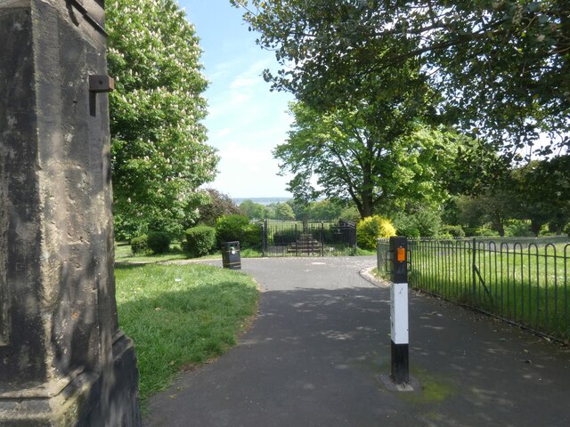
Victoria Park is a picturesque public park located in the county of Cheshire, England. Spanning over 20 acres, the park is situated in the heart of the charming market town of Widnes. Named after Queen Victoria, the park was established in 1900 and has since become a beloved recreational spot for residents and visitors alike.

The park boasts a diverse range of amenities, making it an ideal destination for individuals of all ages. Its well-maintained green spaces provide ample room for leisurely walks, picnics, and outdoor activities. Visitors can also enjoy the park's beautifully landscaped gardens, which showcase an array of colorful flowers and plants.

For sports enthusiasts, Victoria Park offers a variety of facilities, including tennis courts, a bowling green, and a skate park. These amenities provide opportunities for physical fitness and friendly competition in a serene and inviting environment.

Children are well catered for in the park, with a large playground featuring swings, slides, and climbing frames. Additionally, the park is home to a small boating lake where families can rent paddle boats and enjoy a leisurely ride on the water.

Victoria Park regularly hosts community events, such as concerts, fairs, and festivals. These gatherings attract a vibrant mix of locals and tourists, fostering a sense of community and celebration.

With its extensive range of recreational pursuits and tranquil atmosphere, Victoria Park is a cherished asset to the town of Widnes and a must-visit destination for those seeking a peaceful retreat amidst the bustling Cheshire countryside.

If you have any feedback on the listing, please let us know in the comments section below.

Victoria Park Images

Images are sourced within 2km of 53.374123/-3.021335 or Grid Reference SJ3286. Thanks to Geograph Open Source API. All images are credited.

Shops behind Balls Road East road sign
Birkenhead Central Railway Station
Mollington Street motive power depot, Birkenhead – 1965 This was the main Birkenhead depot, provided locomotives for both passenger services and the heavy freight traffic out of Birkenhead docks. A variety of locomotives can be seen in this view.

Centre stage is 42968, one of the 2-6-0 locomotives designed by William Stanier soon after he moved to the LMS Railway. This particular locomotive has survived into preservation as the sole survivor of the class and is currently (2021) at the Severn Valley Railway <a title="https://www.geograph.org.uk/photo/2440423" href="https://www.geograph.org.uk/photo/2440423">Link</a>
Mollington Street motive power depot, Birkenhead – 1965
This was the main Birkenhead depot, provided locomotives for both passenger services and the heavy freight traffic out of Birkenhead docks. A variety of locomotives can be seen in this view. Centre stage is 42968, one of the 2-6-0 locomotives designed by William Stanier soon after he moved to the LMS Railway. This particular locomotive has survived into preservation as the sole survivor of the class and is currently (2021) at the Severn Valley Railway Link
Cammell Laird Shipyard Cammell Laird Shipyard on the River Mersey with RFA Tideforce A139 on site
Cammell Laird Shipyard
Cammell Laird Shipyard on the River Mersey with RFA Tideforce A139 on site
Tranmere Oil Terminal Tranmere Oil Terminal pier with storage tanks behind
Tranmere Oil Terminal
Tranmere Oil Terminal pier with storage tanks behind
Bus in Oxton Village – 1971 Out of a fleet of more than 200 buses, Birkenhead Corporation never had more than a handful of single deckers. No.91 was one of four Leyland Leopards with rather boxy Massey bodywork, new in 1964, and is seen after the fleet was integrated into the Merseyside Passenger Transport Executive, although still in basic Birkenhead livery. These small buses were used on a couple of routes where smaller vehicles were appropriate, including route 97 to Oxton Village, but this view has historic significance as it was the final day of bus operation into the village itself.

This is one of a series of views featuring buses in the 60s, 70s, and 80s. <a title="https://www.geograph.org.uk/search.php?i=137652761" href="https://www.geograph.org.uk/search.php?i=137652761">Link</a>
Bus in Oxton Village – 1971
Out of a fleet of more than 200 buses, Birkenhead Corporation never had more than a handful of single deckers. No.91 was one of four Leyland Leopards with rather boxy Massey bodywork, new in 1964, and is seen after the fleet was integrated into the Merseyside Passenger Transport Executive, although still in basic Birkenhead livery. These small buses were used on a couple of routes where smaller vehicles were appropriate, including route 97 to Oxton Village, but this view has historic significance as it was the final day of bus operation into the village itself. This is one of a series of views featuring buses in the 60s, 70s, and 80s. Link
Birkenhead Central Station 
Birkenhead Central station was opened in 1886 as part of the Mersey Railway's route from Liverpool, via the Mersey Railway Tunnel under the River Mersey. The station was the location of the Mersey Railway's headquarters. The station platforms were refurbished and finished in 2012.
Birkenhead Central Station
Birkenhead Central station was opened in 1886 as part of the Mersey Railway's route from Liverpool, via the Mersey Railway Tunnel under the River Mersey. The station was the location of the Mersey Railway's headquarters. The station platforms were refurbished and finished in 2012.
Birkenhead Bus Station
The Mount
The Mount
Victoria Park, Tranmere North-west entrance to the park from Bebington Road.
Victoria Park, Tranmere
North-west entrance to the park from Bebington Road.
Cammell Laird shipyard, Birkenhead At the time there were two Royal Fleet Auxiliary ships in the dry docks for maintenance.
Cammell Laird shipyard, Birkenhead
At the time there were two Royal Fleet Auxiliary ships in the dry docks for maintenance.
Cammell Laird's yellow cranes The famous Birkenhead shipyard.
Cammell Laird's yellow cranes
The famous Birkenhead shipyard.
Cammell Laird, Birkenhead The legendary Cammell Laird Yard on the Mersey at Birkenhead.
Cammell Laird, Birkenhead
The legendary Cammell Laird Yard on the Mersey at Birkenhead.
Williamson Art Gallery And Museum Well worth a visit.
Williamson Art Gallery And Museum
Well worth a visit.
St Mary's Tower Birkenhead In 1999 the tower was dedicated as a memorial to those who died on the submarine Thetis which sank 60 years previously on sea trials in Liverpool Bay off the North Wales coast. The names of the 99 men who died are recorded as you move up and down the 101 steps to reach the parapet and the unparalleled views of the river, Liverpool and Birkenhead but, most particularly, the shipyard of Cammell Laird so many ships of importance to the country’s history, including Thetis, were built.
** Courtesy Birkenhead Priory
St Mary's Tower Birkenhead
In 1999 the tower was dedicated as a memorial to those who died on the submarine Thetis which sank 60 years previously on sea trials in Liverpool Bay off the North Wales coast. The names of the 99 men who died are recorded as you move up and down the 101 steps to reach the parapet and the unparalleled views of the river, Liverpool and Birkenhead but, most particularly, the shipyard of Cammell Laird so many ships of importance to the country’s history, including Thetis, were built. ** Courtesy Birkenhead Priory
Mizzen Mast from HMS Conway The only remaining part of the original Mizzen Mast of the Training Ship HMS Conway in St Mary's Tower.
Mizzen Mast from HMS Conway
The only remaining part of the original Mizzen Mast of the Training Ship HMS Conway in St Mary's Tower.
Plaque commemorating the HMS THETIS disaster To the memory of the 99 men who lost their lives in Liverpool Bay - to be seen in St. Mary's Tower, Birkenhead.
Plaque commemorating the HMS THETIS disaster
To the memory of the 99 men who lost their lives in Liverpool Bay - to be seen in St. Mary's Tower, Birkenhead.
Borough Road, Birkenhead – 1972 Classic inter-war semi-detached housing development along what was a traditional highway between Birkenhead and Higher Bebington, originally named Happy Valley Road. The elegant cast iron lighting columns were a typical feature of Birkenhead.

The bus is Birkenhead Corporation 360, a Guy Arab IV with Massey bodywork running out of service to take up service somewhere in the Bebington area.

This is one of a series of views featuring buses in the 60s, 70s, and 80s. <a title="https://www.geograph.org.uk/search.php?i=137652761" href="https://www.geograph.org.uk/search.php?i=137652761">Link</a>
Borough Road, Birkenhead – 1972
Classic inter-war semi-detached housing development along what was a traditional highway between Birkenhead and Higher Bebington, originally named Happy Valley Road. The elegant cast iron lighting columns were a typical feature of Birkenhead. The bus is Birkenhead Corporation 360, a Guy Arab IV with Massey bodywork running out of service to take up service somewhere in the Bebington area. This is one of a series of views featuring buses in the 60s, 70s, and 80s. Link
Show me another place!

Victoria Park is located at Grid Ref: SJ3286 (Lat: 53.374123, Lng: -3.021335)

Unitary Authority: Wirral

Police Authority: Merseyside

What 3 Words

///humble.rated.crowd. Near Birkenhead, Merseyside

Related Wikis

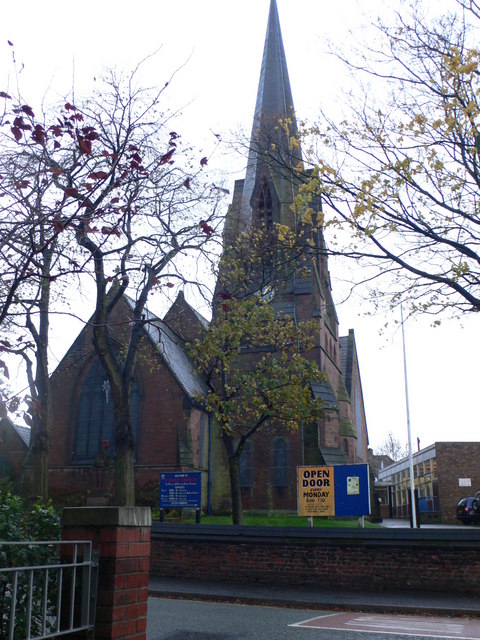
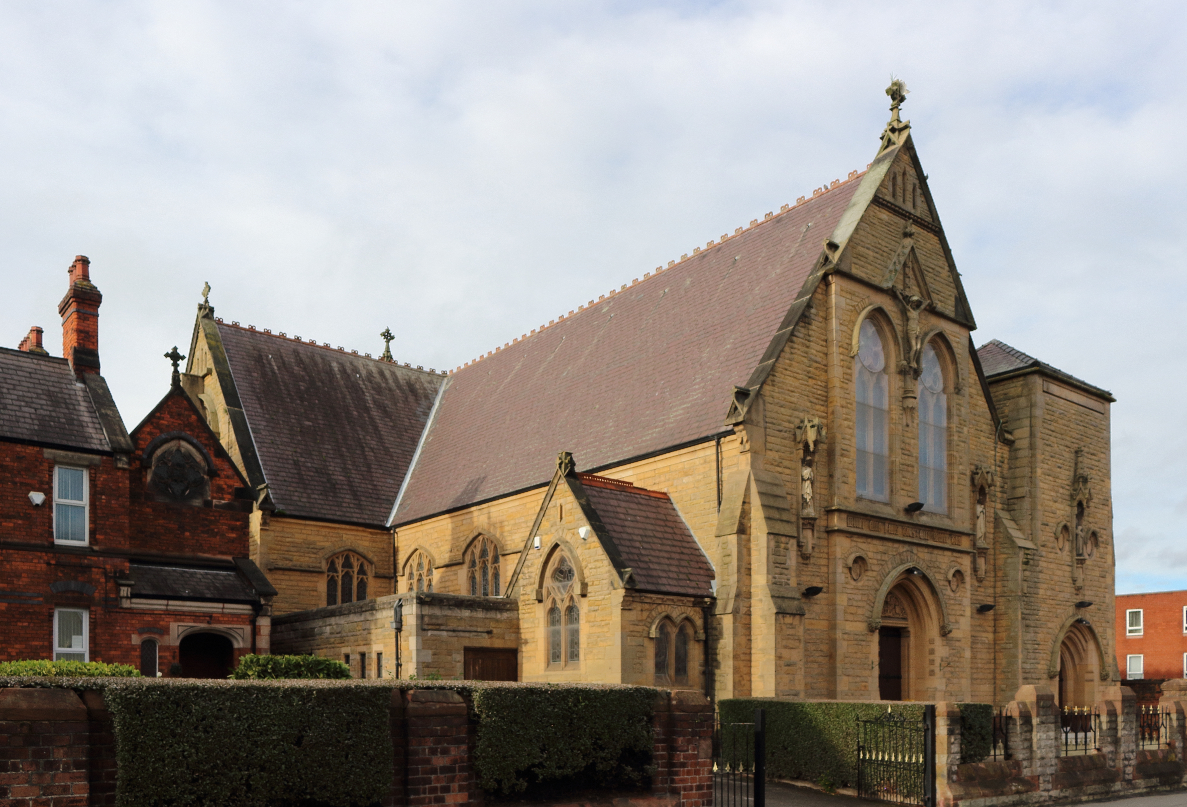
Church of St Paul with St Luke, Tranmere

The Church of St Paul with St Luke is in Old Chester Road, Tranmere, Merseyside, England. It is an active Anglican parish church in the deanery of Birkenhead...

Tranmere, Merseyside

Tranmere is a suburb of Birkenhead, on the Wirral Peninsula, England. Administratively, it is within the Birkenhead and Tranmere Ward of the Metropolitan...

Tranmere railway station

Tranmere was a railway station on the Chester and Birkenhead Railway in Cheshire, England. It opened in 1846 and closed in 1857 and consisted of two platforms...

Prenton High School for Girls

Prenton High School for Girls is an academy school for girls between the ages of 11 and 16 in Rock Ferry, Birkenhead, Wirral, England. == Overview == This...

Rock Ferry railway station

Rock Ferry railway station is situated in the Rock Ferry area of Birkenhead, Merseyside, England. The station lies 4.5 miles (7 km) south west of Liverpool...

Prenton Park

Prenton Park is a large outdoor seated association football stadium in Birkenhead, England. It is the home ground of Tranmere Rovers, as well as Liverpool...

St Anne's Church, Rock Ferry

St Anne's Church is a Roman Catholic church on Highfield Road in Rock Ferry, Birkenhead, Merseyside, England. It is a Grade II listed building. == History... ==

St Catherine's Health Centre

St Catherine's Health Centre, formerly St Catherine's Hospital, is a community hospital in Tranmere, Birkenhead, England. St Catherine's is managed by...

Nearby Amenities

Located within 500m of 53.374123,-3.021335
Crossing
Crossing: traffic_signals
Crossing Ref: puffin
Kerb: lowered
Tactile Paving: yes
Lat/Long: 53.3746565/-3.0150052
Post Box
Description: Queen Victoria Type A post box CH42 145 on Bedford Avenue, Rock Ferry.
Operator: Royal Mail
Operator Wikidata: Q638098
Post Box Design: type_a
Post Box Type: pillar
Ref: CH42 145
Royal Cypher: VR
Royal Cypher Wikidata: Q33102356
Wikimedia Commons: File:Post box on Bedford Avenue, Rock Ferry.jpg
Lat/Long: 53.3709924/-3.0188159
Pub
The Fairfield
Lat/Long: 53.3749173/-3.0152052
Englewood Residential Care Home
Created By: Potlatch 0.8c
Note: Care Home
Lat/Long: 53.3697698/-3.0202975
Bank
Barclays
Brand: Barclays
Brand Wikidata: Q245343
Brand Wikipedia: en:Barclays
Operator: Barclays Bank PLC
Lat/Long: 53.3742368/-3.0253574
Pub
The Sportsmans Arms
Operator: Stonegate
Operator Wikidata: Q7619176
Website: https://www.craftunionpubs.com/sportsmans-arms-prenton-east
Lat/Long: 53.3754563/-3.0261777
Pharmacy
Healthcare: pharmacy
Lat/Long: 53.3759457/-3.0261867
Bus Stop
Old Chester Rd/southwick Road
Bus: yes
Naptan AtcoCode: 2800S20010A
Naptan Bearing: N
Naptan CommonName: Old Chester Rd/southwick Road
Naptan Indicator: Old Chester Road/southwick Road
Naptan Landmark: Between Crofton Road And Southwick Road O/s 212
Naptan NaptanCode: merajtgj
Naptan Notes: No Notes
Naptan ShortCommonName: Tranmere Utd Reform
Naptan Street: Old Chester Road
Naptan Verified: no
Public Transport: platform
Shelter: yes
Source: naptan_import
Lat/Long: 53.3765079/-3.0160214
Bus Stop
OLD CHESTER ROAD/SOUTHWICK ROAD
Bench: no
Bin: no
Bus: yes
Lit: yes
Naptan AtcoCode: 2800S20010B
Naptan Bearing: N
Naptan CommonName: OLD CHESTER ROAD/SOUTHWICK ROAD
Naptan Indicator: OLD CHESTER ROAD/SOUTHWICK ROAD
Naptan Landmark: O/S TRANMERE UNITED REFORM CHURCH
Naptan NaptanCode: merajtgm
Naptan Notes: No Notes
Naptan ShortCommonName: Tranmere Utd Reform
Naptan Street: OLD CHESTER ROAD
Naptan Verified: no
Public Transport: platform
Shelter: no
Source: naptan_import
Tactile Paving: no
Lat/Long: 53.3771636/-3.0160821
Bus Stop
GROVE RD/ROCK FERRY LIBRARY
Bus: yes
Naptan AtcoCode: 2800S20011A
Naptan Bearing: NW
Naptan CommonName: GROVE RD/ROCK FERRY LIBRARY
Naptan Indicator: GROVE ROAD / ST PAULS ROAD
Naptan Landmark: O/S ROCK FERRY LIBRARY C/O OLD CHESTER ROAD
Naptan NaptanCode: merajtgp
Naptan Notes: No Notes
Naptan ShortCommonName: Rock Ferry Library
Naptan Street: GROVE ROAD
Naptan Verified: no
Public Transport: platform
Source: naptan_import
Lat/Long: 53.3740844/-3.0145357
Bus Stop
OLD CHESTER RD/WELL LANE
Bus: yes
Naptan AtcoCode: 2800S20011B
Naptan Bearing: S
Naptan CommonName: OLD CHESTER RD/WELL LANE
Naptan Indicator: OLD CHESTER ROAD/ST PAULS ROAD
Naptan Landmark: O/S SHOP 267
Naptan NaptanCode: merajtgt
Naptan Notes: No Notes
Naptan ShortCommonName: Farifield Hotel
Naptan Street: OLD CHESTER ROAD
Naptan Verified: no
Public Transport: platform
Source: naptan_import
Lat/Long: 53.3751401/-3.015132
Bus Stop
BEDFORD DRIVE/BEBINGTON ROAD
Bus: yes
Naptan AtcoCode: 2800S20040A
Naptan Bearing: E
Naptan CommonName: BEDFORD DRIVE/BEBINGTON ROAD
Naptan Indicator: BEDFORD DRIVE/BEBINGTON ROAD
Naptan Landmark: O/S 10/12
Naptan NaptanCode: merajwpt
Naptan Notes: No Notes
Naptan ShortCommonName: Bedford Dr/B'Ton Rd
Naptan Street: BEDFORD DRIVE
Naptan Verified: no
Public Transport: platform
Source: naptan_import
Lat/Long: 53.3707487/-3.0230389
Bus Stop
BEDFORD AVE/BEBINGTON ROAD
Bus: yes
Naptan AtcoCode: 2800S20040B
Naptan Bearing: W
Naptan CommonName: BEDFORD AVE/BEBINGTON ROAD
Naptan Indicator: BEDFORD AVENUE/BEBINGTON ROAD
Naptan Landmark: O/S 81/83
Naptan NaptanCode: merajwpw
Naptan Notes: No Notes
Naptan ShortCommonName: B'Ford Av/B'Ton Rd
Naptan Street: BEDFORD AVENUE
Naptan Verified: no
Public Transport: platform
Source: naptan_import
Lat/Long: 53.3707443/-3.0214606
Bus Stop
Bebington Road/bedford Drive
Bus: yes
Naptan AtcoCode: 2800S20040C
Naptan Bearing: N
Naptan CommonName: Bebington Road/bedford Drive
Naptan Indicator: Bebington Road/bedford Drive
Naptan Landmark: O/s 96
Naptan NaptanCode: merajwta
Naptan Notes: No Notes
Naptan ShortCommonName: Victoria Park
Naptan Street: Bebington Road
Naptan Verified: no
Public Transport: platform
Source: naptan_import
Lat/Long: 53.3713904/-3.0226334
Bus Stop
Bebington Road/bedford Drive
Bus: yes
Naptan AtcoCode: 2800S20040D
Naptan Bearing: S
Naptan CommonName: Bebington Road/bedford Drive
Naptan Indicator: Bebington Road/bedford Drive
Naptan Landmark: Opp 104 O/s Park
Naptan NaptanCode: merajwtd
Naptan Notes: No Notes
Naptan ShortCommonName: Victoria Park
Naptan Street: Bebington Road
Naptan Verified: no
Public Transport: platform
Source: naptan_import
Lat/Long: 53.3712137/-3.0222835
Bus Stop
BEDFORD AVENUE/OLD CHESTER ROAD
Bus: yes
Naptan AtcoCode: 2800S20041A
Naptan Bearing: W
Naptan CommonName: BEDFORD AVENUE/OLD CHESTER ROAD
Naptan Indicator: BEDFORD AVENUE/OLD CHESTER ROAD
Naptan Landmark: O/S 1/3
Naptan NaptanCode: merajwtg
Naptan Notes: No Notes
Naptan ShortCommonName: Fieldside Rd
Naptan Street: BEDFORD AVENUE
Naptan Verified: no
Public Transport: platform
Source: naptan_import
Lat/Long: 53.3710589/-3.0161923
Bus Stop
BEDFORD AVE/OLD CHESTER ROAD
Bus: yes
Naptan AtcoCode: 2800S20041B
Naptan Bearing: E
Naptan CommonName: BEDFORD AVE/OLD CHESTER ROAD
Naptan Indicator: BEDFORD AVENUE/OLD CHESTER ROAD
Naptan Landmark: O/S 14/16
Naptan NaptanCode: merajwtj
Naptan Notes: No Notes
Naptan ShortCommonName: Fieldside Rd
Naptan Street: BEDFORD AVENUE
Naptan Verified: no
Public Transport: platform
Source: naptan_import
Lat/Long: 53.3710799/-3.0168993
Bus Stop
GREENWAY ROAD/STUART ROAD
Bus: yes
Naptan AtcoCode: 2800S20055A
Naptan Bearing: N
Naptan CommonName: GREENWAY ROAD/STUART ROAD
Naptan Indicator: GREENWAY ROAD/STUART ROAD ROAD
Naptan Landmark: O/S PUMP STATION
Naptan NaptanCode: meramamg
Naptan Notes: No Notes
Naptan ShortCommonName: Stuart Rd
Naptan Street: GREENWAY ROAD
Naptan Verified: no
Public Transport: platform
Source: naptan_import
Lat/Long: 53.3765355/-3.0264547
Bus Stop
GREENWAY ROAD/STUART ROAD
Bus: yes
Naptan AtcoCode: 2800S20055B
Naptan Bearing: S
Naptan CommonName: GREENWAY ROAD/STUART ROAD
Naptan Indicator: GREENWAY ROAD/BEBINGTON ROAD
Naptan Landmark: O/S 101 CORNER PRENTON ROAD EAST
Naptan NaptanCode: meramamj
Naptan Notes: No Notes
Naptan ShortCommonName: Stuart Rd
Naptan Street: GREENWAY ROAD
Naptan Verified: no
Public Transport: platform
Source: naptan_import
Lat/Long: 53.3757579/-3.0259249
Bus Stop
Mount Road/bebington Road
Bus: yes
Naptan AtcoCode: 2800S20056A
Naptan Bearing: NE
Naptan CommonName: Mount Road/bebington Road
Naptan Indicator: Mount Road/bebington Road
Naptan Landmark: O/s 1
Naptan NaptanCode: meramamp
Naptan Notes: No Notes
Naptan ShortCommonName: Mt Rd/bebington Rd
Naptan Street: Mount Road
Naptan Verified: no
Public Transport: platform
Source: naptan_import
Lat/Long: 53.3740441/-3.025568
Bus Stop
Bebington Road/mount Rd
Bus: yes
Naptan AtcoCode: 2800S20056B
Naptan Bearing: NW
Naptan CommonName: Bebington Road/mount Rd
Naptan Indicator: Bebington Road/mount Road
Naptan Landmark: Opp Shop. 10
Naptan NaptanCode: meramamt
Naptan Notes: No Notes
Naptan ShortCommonName: Bebington Rd/mt Rd
Naptan Street: Bebington Road
Naptan Verified: no
Public Transport: platform
Source: naptan_import
Lat/Long: 53.3741218/-3.0248935
Bus Stop
Church Road/bebington Road
Bus: yes
Naptan AtcoCode: 2800S20056C
Naptan Bearing: N
Naptan CommonName: Church Road/bebington Road
Naptan Indicator: Church Road/bebington Road
Naptan Landmark: Adj No.154 C/o Prenton Road East
Naptan NaptanCode: meramamw
Naptan Notes: No Notes
Naptan ShortCommonName: Ch Rd/bebington Rd
Naptan Street: Church Road
Naptan Verified: no
Public Transport: platform
Source: naptan_import
Lat/Long: 53.375377/-3.0252693
Bus Stop
Bebington Road/mount Road
Bus: yes
Naptan AtcoCode: 2800S20056D
Naptan Bearing: NW
Naptan CommonName: Bebington Road/mount Road
Naptan Indicator: Bebington Road/mount Road
Naptan Landmark: O/s Shop 8/10
Naptan NaptanCode: meramapa
Naptan Notes: No Notes
Naptan ShortCommonName: Bebington Rd/mt Rd
Naptan Street: Bebington Road
Naptan Verified: no
Public Transport: platform
Source: naptan_import
Lat/Long: 53.3740748/-3.0251328
Bus Stop
Mount Road/irvine Road
Bus: yes
Naptan AtcoCode: 2800S20059A
Naptan Bearing: N
Naptan CommonName: Mount Road/irvine Road
Naptan Indicator: Mount Road/bebington Road
Naptan Landmark: Corner Ingleborough Road O/s 54/52
Naptan NaptanCode: meramapt
Naptan Notes: No Notes
Naptan ShortCommonName: Mount Rd/irvine Rd
Naptan Street: Mount Road
Naptan Verified: no
Public Transport: platform
Source: naptan_import
Lat/Long: 53.3724774/-3.0265017
Bus Stop
Mount Road / St Georges Avenue
Bus: yes
Naptan AtcoCode: 2800S20059B
Naptan Bearing: S
Naptan CommonName: Mount Road / St Georges Avenue
Naptan Indicator: Mount Road / Irvine Road
Naptan Landmark: Opp Irvine Road O/s No.61-63
Naptan NaptanCode: meramapw
Naptan Notes: No Notes
Naptan ShortCommonName: Mt Rd/st Georges Av
Naptan Street: Mount Road
Naptan Verified: no
Public Transport: platform
Source: naptan_import
Lat/Long: 53.3720224/-3.0265115
Bus Stop
CHURCH ROAD/DIAL ROAD
Bus: yes
Naptan AtcoCode: 2800S20060A
Naptan Bearing: N
Naptan CommonName: CHURCH ROAD/DIAL ROAD
Naptan Indicator: CHURCH ROAD / DIAL ROAD
Naptan Landmark: NR GLADSTONE LIBERAL CLUB
Naptan NaptanCode: meramata
Naptan Notes: No Notes
Naptan ShortCommonName: Church Rd/Dial Rd
Naptan Street: CHURCH ROAD
Naptan Verified: no
Public Transport: platform
Source: naptan_import
Lat/Long: 53.3772739/-3.0252548
Bus Stop
CHURCH ROAD/DIAL ROAD
Bus: yes
Naptan AtcoCode: 2800S20060B
Naptan Bearing: S
Naptan CommonName: CHURCH ROAD/DIAL ROAD
Naptan Indicator: CHURCH ROAD / DIAL ROAD
Naptan Landmark: O/S NO.191
Naptan NaptanCode: meramatd
Naptan Notes: No Notes
Naptan ShortCommonName: Church Rd/Dial Rd
Naptan Street: CHURCH ROAD
Naptan Verified: no
Public Transport: platform
Source: naptan_import
Lat/Long: 53.377482/-3.0250944
Taxi
GROVE ROAD
Naptan AtcoCode: 2800TX00133
Naptan CommonName: GROVE ROAD
Naptan Indicator: GROVE ROAD
Naptan Landmark: GROVE ROAD
Naptan Notes: No Notes
Naptan Street: GROVE ROAD
Naptan Verified: no
Source: naptan_import
Lat/Long: 53.3744607/-3.0146799
B.I.Cycles
Shop: bicycle
Lat/Long: 53.3737414/-3.0246284
Lidl
Addr Country: GB
Addr Housenumber: 2A
Addr Postcode: CH42 3UZ
Addr Street: St Paul's Road
Brand: Lidl
Brand Wikidata: Q151954
Brand Wikipedia: en:Lidl
Fhrs Id: 394619
Shop: supermarket
Website: https://www.lidl.co.uk/s/en-GB/store-finder/rock-ferry/st-pauls-rd-2a/
Lat/Long: 53.3746453/-3.014607
Crossing
Crossing: traffic_signals
Crossing Ref: puffin
Kerb: lowered
Tactile Paving: yes
Lat/Long: 53.3767921/-3.0250206
Crossing
Crossing: uncontrolled
Crossing Island: no
Crossing Markings: yes
Lat/Long: 53.3751458/-3.0206127
Fast Food
Golden Palace (Chinese)
Cuisine: fish_and_chips
Lat/Long: 53.3764984/-3.0178981
Doctors
Gladstone Medical Centre
No
Emergency: no
Healthcare: doctor
Lat/Long: 53.3758359/-3.0154465
Crossing
Crossing: traffic_signals
Crossing Ref: puffin
Kerb: lowered
Tactile Paving: yes
Lat/Long: 53.3754729/-3.0153787
Fine Food and Wine
Shop: convenience
Lat/Long: 53.3757685/-3.0156504
Sayers
Shop: bakery
Lat/Long: 53.3755159/-3.0151569
Morrisons Daily
Addr Country: GB
Addr Housenumber: 229-231
Addr Postcode: CH42 3TD
Addr Street: Old Chester Road
Brand: Morrisons Daily
Brand Wikidata: Q99752411
Check Date: 2022-04-09
Fhrs Id: 1002512
Old Name: The Co-operative Food
Operator: McColl's
Operator Wikidata: Q16997477
Shop: convenience
Lat/Long: 53.3763064/-3.0156397
Cafe
Rumbling Tums
Lat/Long: 53.3754983/-3.0152454
Pharmacy
Swettenham Chemists
Dispensing: yes
Healthcare: pharmacy
Lat/Long: 53.375743/-3.0153875
Pub
The Rock Villa
Lat/Long: 53.3718789/-3.0155496
council office
Office: company
Lat/Long: 53.3755391/-3.0149287
Post Box
Description: George V Type A post box CH42 74 by McDowell Stevens on Greenway Road at junction of Hawthorne Road, with pouch box.
Manufacturer: McDowell Stevens
Operator: Royal Mail
Operator Wikidata: Q638098
Post Box Design: type_a
Post Box Type: pillar
Ref: CH42 74
Royal Cypher: GR
Royal Cypher Wikidata: Q33102273
Wikimedia Commons: File:Post box on Greenway Road, Tranmere.jpg
Lat/Long: 53.376836/-3.0266256
Noexit: yes
Lat/Long: 53.3733975/-3.0278289
Noexit: yes
Lat/Long: 53.3735208/-3.0279041
Power: substation
Lat/Long: 53.3741573/-3.0282624
Generator Method: photovoltaic
Generator Output Electricity: yes
Generator Source: solar
Generator Type: solar_photovoltaic_panel
Location: roof
Power: generator
Lat/Long: 53.3706292/-3.0200118
Post Box
Description: QEII Type K post box CH42 2 on Well Lane, Rock Ferry, on the edge of Victoria Park.
Latitude: -3.02152
Longitude: 53.37512
Operator: Royal Mail
Operator Wikidata: Q638098
Post Box Design: type_k
Post Box Type: pillar
Ref: CH42 2
Royal Cypher: EIIR
Royal Cypher Wikidata: Q33102113
Wikimedia Commons: File:Post box on Well Lane, Rock Ferry.jpg
Lat/Long: 53.3751243/-3.0215258
Post Box
Collection Times: Mo-Fr 17:00; Sa 12:00
Description: George VI Type A post box CH42 77 by Carron Company at former Tranmere Post Office, Old Chester Road, Rock Ferry. The post office has moved nearby to a small shopping estate.
Manufacturer: Carron Company
Operator: Royal Mail
Operator Wikidata: Q638098
Post Box Design: type_a
Post Box Type: pillar
Ref: CH42 77
Royal Cypher: GVIR
Royal Cypher Wikidata: Q33102169
Wikimedia Commons: File:Post box at former Tranmere Post Office.jpg
Lat/Long: 53.3757619/-3.0154656
Post Box
Description: GVIR type A post box CH42 293 by Carron Company at Allcot Avenue/Mount Road, Tranmere.
Manufacturer: Carron Company
Operator: Royal Mail
Operator Wikidata: Q638098
Post Box Design: type_a
Post Box Type: pillar
Ref: CH42 293
Royal Cypher: GVIR
Royal Cypher Wikidata: Q33102169
Wikimedia Commons: File:Post box at Allcot Avenue, Tranmere.jpg
Lat/Long: 53.37175/-3.0266822
Post Box
Description: EIIR type A post box CH42 257 by Carron Company on Bebington Road near junction of Mount Road.
Manufacturer: Carron Company
Operator: Royal Mail
Operator Wikidata: Q638098
Post Box Design: type_a
Post Box Type: pillar
Ref: CH42 257
Royal Cypher: EIIR
Royal Cypher Wikidata: Q33102113
Wikimedia Commons: File:Post box at Bebington Road.jpg
Lat/Long: 53.3739616/-3.0250081
Bicycle Parking
Access: yes
Bicycle Parking: stands
Capacity: 1
Covered: no
Fee: no
Lat/Long: 53.3769973/-3.0250561
Leisure: playground
Playground: youth_bench
Lat/Long: 53.374397/-3.0209844
Leisure: playground
Playground: youth_bench
Lat/Long: 53.3743926/-3.0209325
The data included in this document is from www.openstreetmap.org. The data is made available under ODbL.

Have you been to Victoria Park?

Leave your review of Victoria Park below (or comments, questions and feedback).