Bowershall

Settlement in Fife

Scotland

Bowershall

Road heading north through Bowershall
Road heading north through Bowershall Credit: Rob Purvis

Bowershall is a small village located in the county of Fife, Scotland. Situated approximately 4 miles west of the town of Cupar, it is nestled in the picturesque countryside of the region. Bowershall has a population of around 300 residents.

The village is characterized by its charming rural setting, with rolling hills, green pastures, and beautiful farmland surrounding it. It is an ideal location for those seeking a peaceful and tranquil lifestyle away from the bustle of city living. The nearby River Eden adds to the scenic beauty of the area, providing opportunities for fishing and leisurely walks along its banks.

Although small in size, Bowershall has a strong sense of community. The village is home to a community hall, which serves as a social hub for various events and gatherings throughout the year. The hall also hosts a range of clubs and activities, catering to different interests and age groups.

Residents of Bowershall primarily rely on nearby towns for amenities and services. Cupar, with its range of shops, supermarkets, and schools, is easily accessible by car or public transport. The village benefits from good transportation links, with regular bus services connecting it to the surrounding areas.

Overall, Bowershall offers a tranquil living environment, surrounded by beautiful scenery and a close-knit community. Its proximity to nearby towns ensures that residents have access to all necessary amenities while enjoying the benefits of a peaceful rural lifestyle.

If you have any feedback on the listing, please let us know in the comments section below.

Bowershall Images

Images are sourced within 2km of 56.103157/-3.451694 or Grid Reference NT0990. Thanks to Geograph Open Source API. All images are credited.
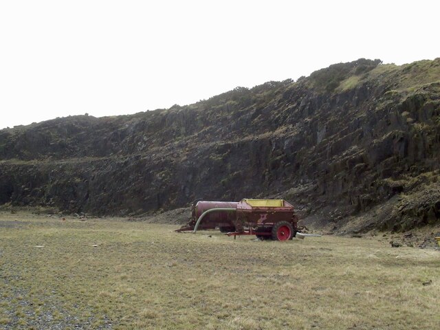
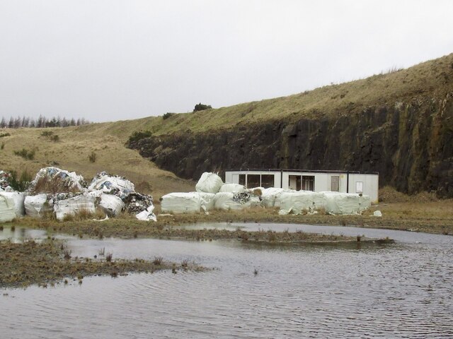
Road heading north through Bowershall
Old Milestone by the A823, Brooklynn, Dunfermline parish Stone post by the A823, by entrance to Brooklynn, in parish of Dunfermline (District), West of junction with the B915, on grass verge, against low stone wall, North side of road.

Inscription reads:-
DUNF
3 M

Surveyed

Milestone Society National ID: FF_DFRB03
Old Milestone by the A823, Brooklynn, Dunfermline parish
Stone post by the A823, by entrance to Brooklynn, in parish of Dunfermline (District), West of junction with the B915, on grass verge, against low stone wall, North side of road. Inscription reads:- DUNF 3 M Surveyed Milestone Society National ID: FF_DFRB03
Farmland near Lochead And field margin trees.
Farmland near Lochead
And field margin trees.
Lochead Landfill Site A large area [ca 50ha] of old workings.
Lochead Landfill Site
A large area [ca 50ha] of old workings.
Wetland pasture, Bowleys
B914 Passing the site of Grove. Lathalmond Hill in the background.
B914
Passing the site of Grove. Lathalmond Hill in the background.
Muddy track near Bowershall Heading south, apparently to nowhere.
Muddy track near Bowershall
Heading south, apparently to nowhere.
Farmland near Bowershall Looking north from Cairncubie Road. This was the area of the Elgin & Westwood Colliery and the Hawthorns follow the line of the West of Fife Section of the North British Railway.
Farmland near Bowershall
Looking north from Cairncubie Road. This was the area of the Elgin & Westwood Colliery and the Hawthorns follow the line of the West of Fife Section of the North British Railway.
Quarry, Lathalmond Hill
Quarry, Lathalmond Hill Abandoned bales of plastic meant for recycling.
Quarry, Lathalmond Hill
Abandoned bales of plastic meant for recycling.
Summit, Lathalmond Hill The hill is quarried and the natural summit may have been lost. Old maps show it to be near the edge of the current rock face.
Summit, Lathalmond Hill
The hill is quarried and the natural summit may have been lost. Old maps show it to be near the edge of the current rock face.
Bowleys Farm
Bowleys Farm
Field below Gaskie Hill
Leadside Crescent, Wellwood Looking west from the end of this cul-de-sac in the small housing estate of Wellwood, on the outskirts of Dunfermline.
Leadside Crescent, Wellwood
Looking west from the end of this cul-de-sac in the small housing estate of Wellwood, on the outskirts of Dunfermline.
Little and large - pylons Pylons of two transmission lines, of different sizes, running along the course of an old railway. Beyond is part of Townhill Country Park.
Little and large - pylons
Pylons of two transmission lines, of different sizes, running along the course of an old railway. Beyond is part of Townhill Country Park.
Shelterbelt on Cairncubie Road A mainly conifer planting separating Cairncubie Road from farmland, between Townhill and Bowershall.
Shelterbelt on Cairncubie Road
A mainly conifer planting separating Cairncubie Road from farmland, between Townhill and Bowershall.
Lochead waste disposal and recycling centre Fife Council are leaders in recycling and waste disposal.  This is a recycling centre at a landfill site reclaimed from mining and quarrying.  Although open long hours seven days a week, visitors still deposit rubbish at the gate.
Lochead waste disposal and recycling centre
Fife Council are leaders in recycling and waste disposal. This is a recycling centre at a landfill site reclaimed from mining and quarrying. Although open long hours seven days a week, visitors still deposit rubbish at the gate.
Farmland Looking NW. The raised ground is the embankment of a disused railway line.Knockhill can be seen in the distance,
Farmland
Looking NW. The raised ground is the embankment of a disused railway line.Knockhill can be seen in the distance,
Show me another place!

Bowershall is located at Grid Ref: NT0990 (Lat: 56.103157, Lng: -3.451694)

Unitary Authority: Fife

Police Authority: Fife

What 3 Words

///grow.festivity.puff. Near Townhill, Fife

Nearby Locations

Bowershall

Related Wikis

Related Videos

Walking in Dunfermline - Scotland

A walk in the city of Dunfermline in Fife, Scotland. 0:00 intro 0:12 Dunfermline High Street 7:01 Dunfermline Abbey 10:39 ...

Fife Walking Trail - Dunfermline West and Pittencrieff Park

This walk starts at Crossford. Following a trip over fields with picturesque views of the Forth, we arrive at the western edge of ...

WALKING IN THE TOWN AS IF YOU WERE WANDERING IN LANDSCAPE by Nicola Atkinson Beautiful Materials

Public Artwork 'Walking in the town as if you were wandering in landscape' by Nicola Atkinson, artist of the Beautiful Materials ...

Dunfermline - City Centre & Pittencrieff Park - Walking Tour | 4K | 60FPS

The Royal Burgh of Dunfermline is a city in Fife, Scotland with an estimated population of 58000. The city is steeped in history with ...

Nearby Amenities

Located within 500m of 56.103157,-3.451694
Bowershall
Place: hamlet
Lat/Long: 56.1043455/-3.4530863
Bowershall Junction
Historic Railway: junction
Railway: site
Lat/Long: 56.1002032/-3.4471687
Power: pole
Lat/Long: 56.1074966/-3.45175
Power: pole
Lat/Long: 56.1069273/-3.4520174
Power: pole
Lat/Long: 56.1062818/-3.4523625
Power: pole
Lat/Long: 56.1055748/-3.4520236
Power: pole
Lat/Long: 56.1051547/-3.4518684
Power: pole
Lat/Long: 56.1047369/-3.4517276
Power: pole
Lat/Long: 56.1043658/-3.4513356
Power: pole
Lat/Long: 56.1040003/-3.4509906
Power: pole
Lat/Long: 56.1035244/-3.4501107
Power: pole
Lat/Long: 56.1030747/-3.4492961
Power: pole
Lat/Long: 56.1026158/-3.4484713
Power: pole
Lat/Long: 56.1021422/-3.4476221
Power: pole
Lat/Long: 56.1016799/-3.446781
Power: pole
Lat/Long: 56.1012142/-3.4459154
Power: pole
Lat/Long: 56.1007485/-3.4450804
Power: pole
Lat/Long: 56.1052936/-3.453273
Power: pole
Lat/Long: 56.1054394/-3.4525727
Power: pole
Lat/Long: 56.105683/-3.4512478
Power: pole
Lat/Long: 56.1043646/-3.4513478
Power: pole
Lat/Long: 56.1045286/-3.4498677
Power: pole
Lat/Long: 56.1046561/-3.4486959
Power: pole
Lat/Long: 56.1050659/-3.4487143
Power: pole
Lat/Long: 56.1042735/-3.4494084
Power: pole
Lat/Long: 56.1039445/-3.4500066
Power: pole
Lat/Long: 56.1035472/-3.4507435
The data included in this document is from www.openstreetmap.org. The data is made available under ODbL.

Have you been to Bowershall?

Leave your review of Bowershall below (or comments, questions and feedback).