Upper Bighouse

Settlement in Sutherland

Scotland

Upper Bighouse

Bunkhouse and Bridge Renovated corn mill and old bridge in Strath Halladale
Bunkhouse and Bridge Credit: John MacKenzie

Upper Bighouse is a small hamlet located in the county of Sutherland, in the northern part of Scotland. Situated amidst the picturesque Scottish Highlands, this remote settlement is nestled within a valley surrounded by rolling hills and stunning natural landscapes.

The hamlet of Upper Bighouse is characterized by its tranquil and secluded atmosphere, making it an ideal destination for those seeking a peaceful retreat. The area is sparsely populated, with only a handful of houses and farms dotting the landscape. The residents of Upper Bighouse primarily engage in agricultural activities, such as sheep farming and crop cultivation, taking advantage of the fertile soil and favorable climatic conditions.

The surrounding area offers ample opportunities for outdoor enthusiasts to explore and enjoy nature. The nearby River Bighouse is renowned for its salmon fishing, attracting anglers from far and wide. Hiking and walking trails, such as the Bighouse Circular Walk, provide visitors with a chance to immerse themselves in the breathtaking scenery and observe the local flora and fauna.

Despite its remote location, Upper Bighouse is within driving distance of several amenities and attractions. The town of Lairg, located approximately 10 miles away, offers shops, restaurants, and other essential services. Additionally, nearby attractions such as the historic Carbisdale Castle and the picturesque Loch Shin provide visitors with further opportunities for exploration and enjoyment.

In summary, Upper Bighouse is a serene and secluded hamlet in Sutherland, Scotland. With its natural beauty and peaceful ambiance, it is an ideal destination for those seeking respite from the hustle and bustle of daily life.

If you have any feedback on the listing, please let us know in the comments section below.

Upper Bighouse Images

Images are sourced within 2km of 58.486772/-3.9227493 or Grid Reference NC8857. Thanks to Geograph Open Source API. All images are credited.

Bunkhouse and Bridge Renovated corn mill and old bridge in Strath Halladale
Bunkhouse and Bridge
Renovated corn mill and old bridge in Strath Halladale
Bridge to Trantlemore One of two river crossings in the area
Bridge to Trantlemore
One of two river crossings in the area
River Halladale River Halladale at Craigtown
River Halladale
River Halladale at Craigtown
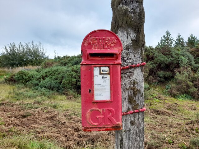
Post Box at Dalhalvaig KW11 41. Royal Mail list this box as 'Bunahoun Bridge Dalhalvaig' however there is another box at that location that I cannot find listed. There is some confusion in the records I suspect. It's an example of a 'Hovis' style box from the reign of King George V.
Post Box at Dalhalvaig
KW11 41. Royal Mail list this box as 'Bunahoun Bridge Dalhalvaig' however there is another box at that location that I cannot find listed. There is some confusion in the records I suspect. It's an example of a 'Hovis' style box from the reign of King George V.
Smigel, Strath Halladale
Smigel Burn and mill View from a newer road bridge.
Smigel Burn and mill
View from a newer road bridge.
Smigel corn mill, Strath Halladale
Smigel Burn, Strath Halladale
River Halladale Bridge carrying a minor road across the river Halladale
River Halladale
Bridge carrying a minor road across the river Halladale
Smigel Mill Disused mill on the Smigel burn.
Smigel Mill
Disused mill on the Smigel burn.
River Halladale Macbeth's Pool, river Halladale.
River Halladale
Macbeth's Pool, river Halladale.
River Halladale and Craigtown Rock Looking downstream from Harpers Pool. Craigtown Rock is the rocky crag in the centre of the picture.
River Halladale and Craigtown Rock
Looking downstream from Harpers Pool. Craigtown Rock is the rocky crag in the centre of the picture.
Strathy and Halladale Church of Scotland
A  Bridge to Trantlemore
A Bridge to Trantlemore
Craigton Spelled Craigtown on maps, the local spelling is Craigton. The name is derived from the Gaelic Baile na Creag, which means 'township by the rock'. A view of Craigton Rock can be seen here > <a href="https://www.geograph.org.uk/photo/428027">NC8956 : River Halladale and Craigtown Rock</a>. Of the three houses that once formed this township, only the one depicted here is left.
Craigton
Spelled Craigtown on maps, the local spelling is Craigton. The name is derived from the Gaelic Baile na Creag, which means 'township by the rock'. A view of Craigton Rock can be seen here > NC8956 : River Halladale and Craigtown Rock. Of the three houses that once formed this township, only the one depicted here is left.
Sheepdog on quad bike It is customary for crofters to use a quad bike when setting out into the hills, and to let their sheepdog ride along on the bike with them when gathering in sheep from the common grazings, so as not to tire them out before their work has started.
Sheepdog on quad bike
It is customary for crofters to use a quad bike when setting out into the hills, and to let their sheepdog ride along on the bike with them when gathering in sheep from the common grazings, so as not to tire them out before their work has started.
View north along Strath Halladale Buildings belonging to Upper Bighouse across the river can be seen in the distance at left. The picture was taken from the track leading up to Craigton Rock just to the south of Craigton.
View north along Strath Halladale
Buildings belonging to Upper Bighouse across the river can be seen in the distance at left. The picture was taken from the track leading up to Craigton Rock just to the south of Craigton.
Smigel Mill in the gloaming This mill, disused for many years, was erected beside Smigel Burn.
Smigel Mill in the gloaming
This mill, disused for many years, was erected beside Smigel Burn.
Show me another place!

Upper Bighouse is located at Grid Ref: NC8857 (Lat: 58.486772, Lng: -3.9227493)

Unitary Authority: Highland

Police Authority: Highlands and Islands

What 3 Words

///footballers.snack.triangles. Near Reay, Highland

Related Wikis

Upper Bighouse

Upper Bighouse is a remote linear crofting township, which lies on the west bank of the Halladale River in the former county of Sutherland. It is now in...

Achiemore, Strath Halladale

Achiemore is a hamlet in Strath Halladale in Sutherland, in the Highland council area of Scotland. Achiemore is situated to the north of Smigel Burn on...

Dalhalvaig

Dalhalvaig (Scottish Gaelic: Dail Healabhaig) is a small crofting village, located in the right bank of the River Halladale in the Scottish council area...

Strath Halladale

Strath Halladale is a strath in the traditional county of Sutherland in the north of Scotland down which the Halladale River flows to enter the Atlantic...

Nearby Amenities

Located within 500m of 58.486772,-3.9227493
Bighouse Hill
Ele: 145
Name Gd: Tòrr Bhiogais
Natural: peak
Lat/Long: 58.4886968/-3.9176508
The data included in this document is from www.openstreetmap.org. The data is made available under ODbL.

Have you been to Upper Bighouse?

Leave your review of Upper Bighouse below (or comments, questions and feedback).