Unapool

Settlement in Sutherland

Scotland

Unapool

The Kylesku Bridge A view of the Kylesku Bridge taken from the start of the armco barrier north side of the bridge.
The Kylesku Bridge Credit: Mr S Mudgey

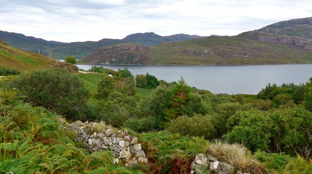
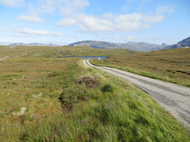
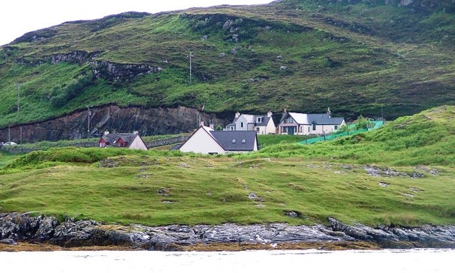
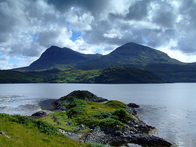
Unapool is a small village located in the county of Sutherland, in the Highlands region of Scotland. Situated on the eastern shore of Loch Glencoul, Unapool offers breathtaking views of the surrounding mountainous landscapes. The village is nestled within the vast and untouched wilderness that characterizes this remote part of Scotland.

Unapool is a tranquil and picturesque place, ideal for those seeking peace and solitude amidst nature. The area is renowned for its unspoiled beauty, with crystal-clear lochs, dense forests, and rugged hills dominating the landscape. It is a haven for outdoor enthusiasts, offering a wide range of activities such as hiking, fishing, and birdwatching.

Despite its small size, Unapool does have a few amenities to cater to both locals and visitors. The village boasts a charming inn that serves as a hub for socializing and enjoying traditional Scottish cuisine. Additionally, there are several self-catering accommodations available for those who wish to stay longer and explore the region at their own pace.

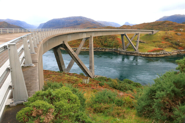
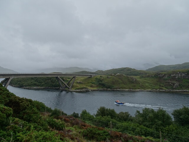
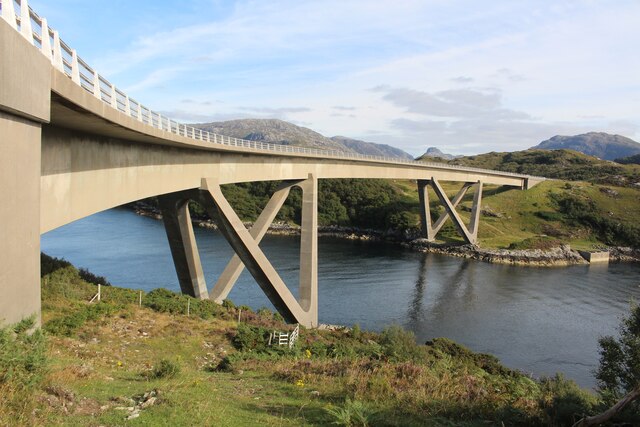
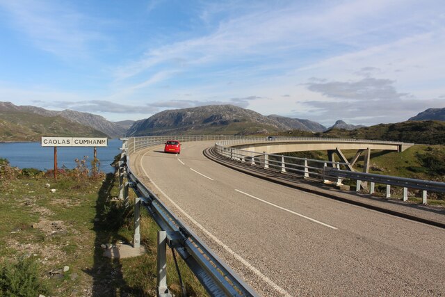
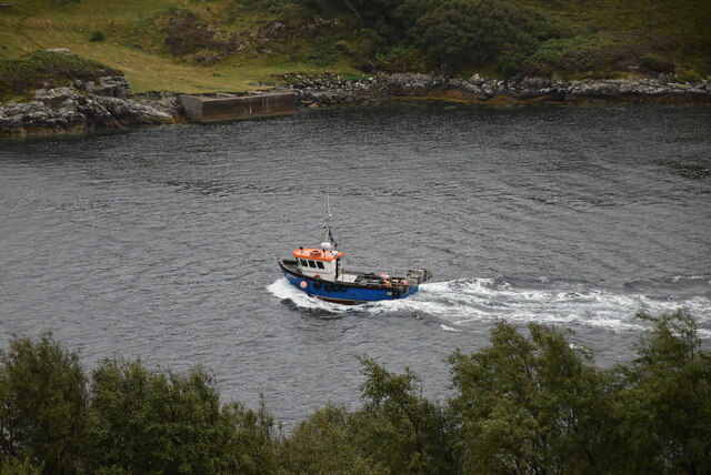
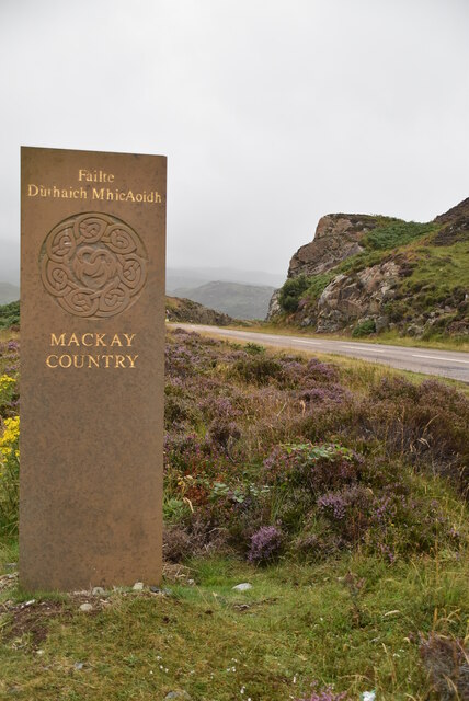
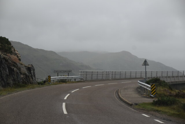
Unapool's proximity to other attractions in Sutherland makes it a convenient base for exploration. Within a short drive, visitors can reach the famous mountains of Quinag and Suilven, as well as the stunning Kylesku Bridge. The nearby Glencoul and Glendhu forests provide ample opportunities for nature walks and wildlife spotting.

Unapool is a hidden gem within the Scottish Highlands, offering a peaceful retreat for nature lovers and adventurers alike. Its untouched landscapes and serene atmosphere make it a must-visit destination for anyone seeking an escape from the hustle and bustle of modern life.

If you have any feedback on the listing, please let us know in the comments section below.

Unapool Images

Images are sourced within 2km of 58.249648/-5.0060232 or Grid Reference NC2332. Thanks to Geograph Open Source API. All images are credited.

The Kylesku Bridge A view of the Kylesku Bridge taken from the start of the armco barrier north side of the bridge.
The Kylesku Bridge
A view of the Kylesku Bridge taken from the start of the armco barrier north side of the bridge.
Loch Glencoul from the A894 There is just a glimpse of Loch Glendhu top left, where it joins with Loch Glencoul before the combined waters flow under the magnificent Kylesku bridge and out to sea.
Loch Glencoul from the A894
There is just a glimpse of Loch Glendhu top left, where it joins with Loch Glencoul before the combined waters flow under the magnificent Kylesku bridge and out to sea.
Kylesku Bridge
Kylesku Bridge
Kylesku Bridge Opened on 8 August 1984. Designed for Highland Regional Council by Ove Arup and Partners Scotland Ltd and built by Morrison Construction Ltd.
Kylesku Bridge
Opened on 8 August 1984. Designed for Highland Regional Council by Ove Arup and Partners Scotland Ltd and built by Morrison Construction Ltd.
Kylesku Bridge Commemorative Stone Designed to replicate the piers supporting the Kylesku Bridge. See <a href="https://www.geograph.org.uk/photo/6988553">NC2233 : Kylesku Bridge Commemorative Plaque</a> for a closer view of the plaques.
Kylesku Bridge Commemorative Stone
Designed to replicate the piers supporting the Kylesku Bridge. See NC2233 : Kylesku Bridge Commemorative Plaque for a closer view of the plaques.
Kylesku Bridge Commemorative Plaque
Kylesku Bridge
Kylesku Bridge
Road (B869) approaching Loch Unapool Looking eastward.
Road (B869) approaching Loch Unapool
Looking eastward.
Caolas Cumhann  This view was taken adjacent to the former ferry slipway; the ferry had ceased to operate the previous year when the impressive new bridge, seen here in the background, was opened. Compare with this view taken 13 years earlier, exactly 10 years before construction started: <a href="https://www.geograph.org.uk/photo/6500717">NC2234 : Caolas Cumhann from beside the Kylesku Ferry slipway</a>.
Caolas Cumhann
This view was taken adjacent to the former ferry slipway; the ferry had ceased to operate the previous year when the impressive new bridge, seen here in the background, was opened. Compare with this view taken 13 years earlier, exactly 10 years before construction started: NC2234 : Caolas Cumhann from beside the Kylesku Ferry slipway.
Submarine Memorial, Kylesku War memorials were mainly constructed after WWI to commemorate the troops who gave their lives in the war. Many were then updated after WWII. Some war memorials date back to the Boer War. Almost every town and village in Britain has a War Memorial. They take many forms, the commonest being an obelisk, a cross or statue of a soldier. Some commemorate the inhabitants of a place, some are for schools and others are for companies or Military groupings.
Many memorials are grade II listed, 61 are II* listed, <span class="nowrap"><a title="https://en.wikipedia.org/wiki/Grade_II" rel="nofollow ugc noopener" href="https://en.wikipedia.org/wiki/Grade_II">Link</a><img style="margin-left:2px;" alt="External link" title="External link - shift click to open in new window" src="https://s1.geograph.org.uk/img/external.png" width="10" height="10"/></span>*_listed_war_memorials_in_England  
 & 12 are Grade I listed. <span class="nowrap"><a title="https://en.wikipedia.org/wiki/Grade_I_listed_war_memorials_in_England" rel="nofollow ugc noopener" href="https://en.wikipedia.org/wiki/Grade_I_listed_war_memorials_in_England">Link</a><img style="margin-left:2px;" alt="External link" title="External link - shift click to open in new window" src="https://s1.geograph.org.uk/img/external.png" width="10" height="10"/></span> 
A search for memorials can be carried out at <span class="nowrap"><a title="http://www.ukniwm.org.uk/server/show/nav.002006003" rel="nofollow ugc noopener" href="http://www.ukniwm.org.uk/server/show/nav.002006003">Link</a><img style="margin-left:2px;" alt="External link" title="External link - shift click to open in new window" src="https://s1.geograph.org.uk/img/external.png" width="10" height="10"/></span>
Submarine Memorial, Kylesku
War memorials were mainly constructed after WWI to commemorate the troops who gave their lives in the war. Many were then updated after WWII. Some war memorials date back to the Boer War. Almost every town and village in Britain has a War Memorial. They take many forms, the commonest being an obelisk, a cross or statue of a soldier. Some commemorate the inhabitants of a place, some are for schools and others are for companies or Military groupings. Many memorials are grade II listed, 61 are II* listed, LinkExternal link*_listed_war_memorials_in_England & 12 are Grade I listed. LinkExternal link A search for memorials can be carried out at LinkExternal link
Kylesku Bridge The A894 runs 23 miles from Skiag Bridge <a href="https://www.geograph.org.uk/photo/7123534">NC2324 : Skiag Bridge</a> to Laxford Bridge.
<span class="nowrap"><a title="https://www.sabre-roads.org.uk/wiki/index.php?title=A894" rel="nofollow ugc noopener" href="https://www.sabre-roads.org.uk/wiki/index.php?title=A894">Link</a><img style="margin-left:2px;" alt="External link" title="External link - shift click to open in new window" src="https://s1.geograph.org.uk/img/external.png" width="10" height="10"/></span>
Kylesku Bridge
The A894 runs 23 miles from Skiag Bridge NC2324 : Skiag Bridge to Laxford Bridge. LinkExternal link
Boat on Coalas Cumhann
Loch a chairn Bhain
Loch a chairn Bhain
Mackay Country
Mackay Country
A894 approaching the Kylesku Bridge The A894 runs 23 miles from Skiag Bridge <a href="https://www.geograph.org.uk/photo/7123534">NC2324 : Skiag Bridge</a> to Laxford Bridge.
<span class="nowrap"><a title="https://www.sabre-roads.org.uk/wiki/index.php?title=A894" rel="nofollow ugc noopener" href="https://www.sabre-roads.org.uk/wiki/index.php?title=A894">Link</a><img style="margin-left:2px;" alt="External link" title="External link - shift click to open in new window" src="https://s1.geograph.org.uk/img/external.png" width="10" height="10"/></span>
A894 approaching the Kylesku Bridge
The A894 runs 23 miles from Skiag Bridge NC2324 : Skiag Bridge to Laxford Bridge. LinkExternal link
A894, Unapool The A894 runs 23 miles from Skiag Bridge <a href="https://www.geograph.org.uk/photo/7123534">NC2324 : Skiag Bridge</a> to Laxford Bridge.
<span class="nowrap"><a title="https://www.sabre-roads.org.uk/wiki/index.php?title=A894" rel="nofollow ugc noopener" href="https://www.sabre-roads.org.uk/wiki/index.php?title=A894">Link</a><img style="margin-left:2px;" alt="External link" title="External link - shift click to open in new window" src="https://s1.geograph.org.uk/img/external.png" width="10" height="10"/></span>
A894, Unapool
The A894 runs 23 miles from Skiag Bridge NC2324 : Skiag Bridge to Laxford Bridge. LinkExternal link
A894 by Loch Glencoul The A894 runs 23 miles from Skiag Bridge <a href="https://www.geograph.org.uk/photo/7123534">NC2324 : Skiag Bridge</a> to Laxford Bridge.
<span class="nowrap"><a title="https://www.sabre-roads.org.uk/wiki/index.php?title=A894" rel="nofollow ugc noopener" href="https://www.sabre-roads.org.uk/wiki/index.php?title=A894">Link</a><img style="margin-left:2px;" alt="External link" title="External link - shift click to open in new window" src="https://s1.geograph.org.uk/img/external.png" width="10" height="10"/></span>
A894 by Loch Glencoul
The A894 runs 23 miles from Skiag Bridge NC2324 : Skiag Bridge to Laxford Bridge. LinkExternal link
Show me another place!

Unapool is located at Grid Ref: NC2332 (Lat: 58.249648, Lng: -5.0060232)

Unitary Authority: Highland

Police Authority: Highlands and Islands

What 3 Words

///playoffs.soups.sweetener. Near Inchnadamph, Highland

Nearby Locations

Unapool Cnoc na Mòine

Related Wikis

Unapool

Unapool is a small settlement in the Assynt district of Sutherland in the Highland council area of Scotland. It is located on the A894 between Durness...

Kylesku

Kylesku (Scottish Gaelic: An Caolas Cumhang) is a small, remote fishing hamlet in Sutherland in the Scottish Highlands. Until 1984, it was the site of...

Kylestrome

Kylestrome (Scottish Gaelic: Caol Sròim) is a village on the north shore of Loch a' Chàirn Bhàin, 2 miles (3 kilometres) northwest of Unapool, in Sutherland...
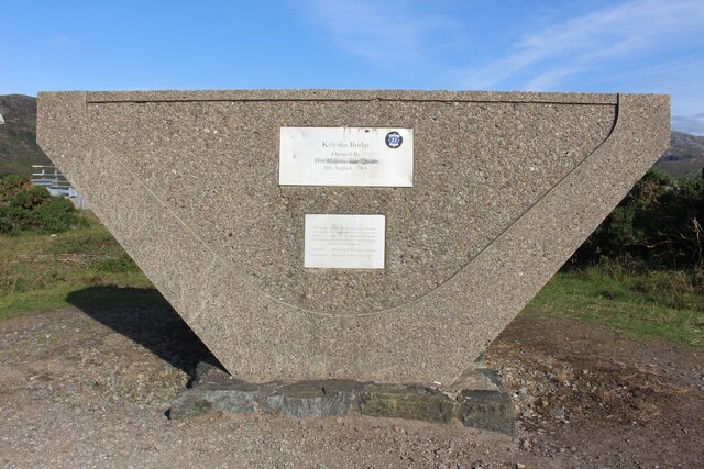
Kylesku Bridge

The Kylesku Bridge (officially known since 2019 by its Gaelic name Drochaid a' Chaolais Chumhaing) is a distinctively curved concrete box girder bridge...

Nearby Amenities

Located within 500m of 58.249648,-5.0060232
Source: PGS
Lat/Long: 58.2459362/-5.004085
Source: PGS
Lat/Long: 58.2462654/-5.0042167
Source: PGS
Lat/Long: 58.2465139/-5.004266
Source: PGS
Lat/Long: 58.2475375/-5.0041008
Source: PGS
Lat/Long: 58.2481823/-5.0040954
Source: PGS
Lat/Long: 58.2484115/-5.0044098
Created By: almien_coastlines
Source: PGS
Lat/Long: 58.249917/-5.00469
Created By: almien_coastlines
Source: PGS
Lat/Long: 58.250059/-5.003727
Created By: almien_coastlines
Source: PGS
Lat/Long: 58.250192/-5.003492
Source: PGS
Lat/Long: 58.2514387/-5.0040139
Source: PGS
Lat/Long: 58.2516267/-5.0043797
Source: PGS
Lat/Long: 58.2518577/-5.0049166
Source: PGS
Lat/Long: 58.2522742/-5.0059247
Source: PGS
Lat/Long: 58.2538871/-5.0056425
Source: PGS
Lat/Long: 58.2541033/-5.0063603
Unapool
Is In: Scotland, Assynt, Sutherland
Place: hamlet
Lat/Long: 58.24961/-5.00748
Turning Circle
Lat/Long: 58.2520972/-5.0089
Tourism: guest_house
Lat/Long: 58.248593/-5.0058893
Power: pole
Lat/Long: 58.2509839/-5.0127522
Power: pole
Lat/Long: 58.2508016/-5.0106108
Power: pole
Lat/Long: 58.2501368/-5.0097854
Power: pole
Lat/Long: 58.2494894/-5.0087439
Power: pole
Lat/Long: 58.2491851/-5.0081755
Power: pole
Lat/Long: 58.2487456/-5.0073851
Power: pole
Lat/Long: 58.2482242/-5.0064546
Power: pole
Lat/Long: 58.2478564/-5.0058063
Power: pole
Lat/Long: 58.2473278/-5.0056486
Power: pole
Lat/Long: 58.2467971/-5.0054851
Power: pole
Lat/Long: 58.2463678/-5.0054111
Power: pole
Lat/Long: 58.2454038/-5.0052632
The data included in this document is from www.openstreetmap.org. The data is made available under ODbL.

Have you been to Unapool?

Leave your review of Unapool below (or comments, questions and feedback).