Bourne

Settlement in Lincolnshire South Kesteven

England

Bourne

Bourne Town Centre Bourne is a "market town" in south Lincolnshire.  This photograph was taken at the centre of town at the junction of North Street, South Street, West Street and Abbey Road.  In years past the market would have been here, now there is just a dangerous amount of traffic and some shops.
Bourne Town Centre Credit: Tony Atkin

Bourne is a market town located in Lincolnshire, England. It has a population of around 14,000 residents and is known for its historic charm and picturesque surroundings. The town is situated on the eastern edge of the Lincolnshire Fens, surrounded by beautiful countryside and agricultural land.

Bourne has a rich history dating back to Roman times, with evidence of settlements and a Roman road passing through the area. The town grew in importance during the medieval period, with the construction of Bourne Abbey in the 12th century. The abbey was later dissolved during the reign of Henry VIII, but its ruins still stand as a reminder of Bourne's past.

Today, Bourne is a thriving community with a range of amenities and attractions for residents and visitors alike. The town has a variety of shops, restaurants, and pubs, as well as a weekly market where local produce and goods are sold. Bourne is also home to several schools, churches, and sports facilities, making it a popular choice for families and young professionals looking to settle in the area.

If you have any feedback on the listing, please let us know in the comments section below.

Bourne Images

Images are sourced within 2km of 52.768243/-0.37717697 or Grid Reference TF0920. Thanks to Geograph Open Source API. All images are credited.

Bourne Town Centre Bourne is a "market town" in south Lincolnshire.  This photograph was taken at the centre of town at the junction of North Street, South Street, West Street and Abbey Road.  In years past the market would have been here, now there is just a dangerous amount of traffic and some shops.
Bourne Town Centre
Bourne is a "market town" in south Lincolnshire. This photograph was taken at the centre of town at the junction of North Street, South Street, West Street and Abbey Road. In years past the market would have been here, now there is just a dangerous amount of traffic and some shops.
West Road, Bourne Early 20th century ribbon development housing along the main road into Bourne from the West.
West Road, Bourne
Early 20th century ribbon development housing along the main road into Bourne from the West.
In Bourne Wood Bourne Wood is an ancient area of woodland on a ridge of mainly poor soil to the west of Bourne.  It was taken over by the Forestry Commission in the 1920's who planted large areas of conifers.  Today it is used mainly as a recreational area for local people and is being gradually restored to native broadleaf woodland. 

Over the years several resident artists have added their contributions to the woodland.  The circular structure of willows in the foreground is a living sculpture by Claire Wilks called "Helter Skelter".
In Bourne Wood
Bourne Wood is an ancient area of woodland on a ridge of mainly poor soil to the west of Bourne. It was taken over by the Forestry Commission in the 1920's who planted large areas of conifers. Today it is used mainly as a recreational area for local people and is being gradually restored to native broadleaf woodland. Over the years several resident artists have added their contributions to the woodland. The circular structure of willows in the foreground is a living sculpture by Claire Wilks called "Helter Skelter".
Edge of Town This dirt road leads to a farm and with a modern housing estate on the southern side of it, marks the edge of the town of Bourne.
Edge of Town
This dirt road leads to a farm and with a modern housing estate on the southern side of it, marks the edge of the town of Bourne.
Nice House!
Nice House!
West Street, Bourne, Lincs Taken from the island in the middle of the main junction in Bourne, looking west.
West Street, Bourne, Lincs
Taken from the island in the middle of the main junction in Bourne, looking west.
Public toilets, South Street, Bourne, Lincs
Garden shed There is a 1970s estate to the northeast of Bourne, with conventional detached houses.  The estate is "open plan" in that the front gardens are unfenced, but the back gardens are individually enclosed.
Garden shed
There is a 1970s estate to the northeast of Bourne, with conventional detached houses. The estate is "open plan" in that the front gardens are unfenced, but the back gardens are individually enclosed.
Blind Well field On the far side of this field is the "Chalybeate well" shown on the OS sheet at TF 085 206
Blind Well field
On the far side of this field is the "Chalybeate well" shown on the OS sheet at TF 085 206
Footpath to Cawthorpe from A15 This footpath is well-used and maintained as a path: the pedestrians and a few cyclists have crops in varying stages of growth from being ploughed up to walking by crops as tall as a child all within a year.

This footpath follows the course of the Roman Road 'King Street', which having come through Bourne from the south makes a turn at the corner on the A15 and heads toward Stainfield and hence to Ancaster.
Footpath to Cawthorpe from A15
This footpath is well-used and maintained as a path: the pedestrians and a few cyclists have crops in varying stages of growth from being ploughed up to walking by crops as tall as a child all within a year. This footpath follows the course of the Roman Road 'King Street', which having come through Bourne from the south makes a turn at the corner on the A15 and heads toward Stainfield and hence to Ancaster.
Bourne Woods car park Part of the car parking area and one of the picnic tables; an information board and toilets are nearby.
Bourne Woods car park
Part of the car parking area and one of the picnic tables; an information board and toilets are nearby.
Bourne Wood carpark A Forestry Commission wood, part of Kesteven Forest. The wood is being gradually restored to native broadleaf woodland under the 'Ancient Woodland Project'. See <span class="nowrap"><a title="http://www.forestry.gov.uk/website/recreation.nsf/LUWebDocsByKey/EnglandLincolnshireKestevenForestBourneWoods" rel="nofollow ugc noopener" href="http://www.forestry.gov.uk/website/recreation.nsf/LUWebDocsByKey/EnglandLincolnshireKestevenForestBourneWoods">Link</a><img style="margin-left:2px;" alt="External link" title="External link - shift click to open in new window" src="https://s1.geograph.org.uk/img/external.png" width="10" height="10"/></span>
Bourne Wood carpark
A Forestry Commission wood, part of Kesteven Forest. The wood is being gradually restored to native broadleaf woodland under the 'Ancient Woodland Project'. See LinkExternal link
Forestry road, Bourne Wood A public bridleway follows this road. It meets the Forest Trail (in the centre of the picture) just over the boundary with <a href="https://www.geograph.org.uk/gridref/TF0820">TF0820</a>.
Forestry road, Bourne Wood
A public bridleway follows this road. It meets the Forest Trail (in the centre of the picture) just over the boundary with TF0820.
Bourne Woods, Lincolnshire See <span class="nowrap"><a title="http://www.forestry.gov.uk/website/recreation.nsf/LUWebDocsByKey/EnglandLincolnshireKestevenForestBourneWoods" rel="nofollow ugc noopener" href="http://www.forestry.gov.uk/website/recreation.nsf/LUWebDocsByKey/EnglandLincolnshireKestevenForestBourneWoods">Link</a><img style="margin-left:2px;" alt="External link" title="External link - shift click to open in new window" src="https://s1.geograph.org.uk/img/external.png" width="10" height="10"/></span>
Bourne Woods, Lincolnshire
See LinkExternal link
Bourne Eau A pleasant waterside footpath on one side (but alongside the busy A15) and the well-kept Memorial Gardens on the other bank.
Bourne Eau
A pleasant waterside footpath on one side (but alongside the busy A15) and the well-kept Memorial Gardens on the other bank.
The  Old Grain Warehouse, South Road This building has been empty and gradually falling apart for years but has recently sold and this should provide a real change of use/scenery as it is transformed into housing.
The Old Grain Warehouse, South Road
This building has been empty and gradually falling apart for years but has recently sold and this should provide a real change of use/scenery as it is transformed into housing.
Bourne Bus Station in the Snow There is regular bus service between Bourne and Peterborough, even in the snow. The building behind the bus stops is St Gilbert Roman Catholic Church.
Bourne Bus Station in the Snow
There is regular bus service between Bourne and Peterborough, even in the snow. The building behind the bus stops is St Gilbert Roman Catholic Church.
Footpath from Bourne Woods The footpath here perches between a stream and the back gardens of a suburban estate in Bourne.
Footpath from Bourne Woods
The footpath here perches between a stream and the back gardens of a suburban estate in Bourne.
Show me another place!

Bourne is located at Grid Ref: TF0920 (Lat: 52.768243, Lng: -0.37717697)

Division: Parts of Kesteven

Administrative County: Lincolnshire

District: South Kesteven

Police Authority: Lincolnshire

What 3 Words

///students.icon.currently. Near Bourne, Lincolnshire

Nearby Locations

Bourne

Related Wikis

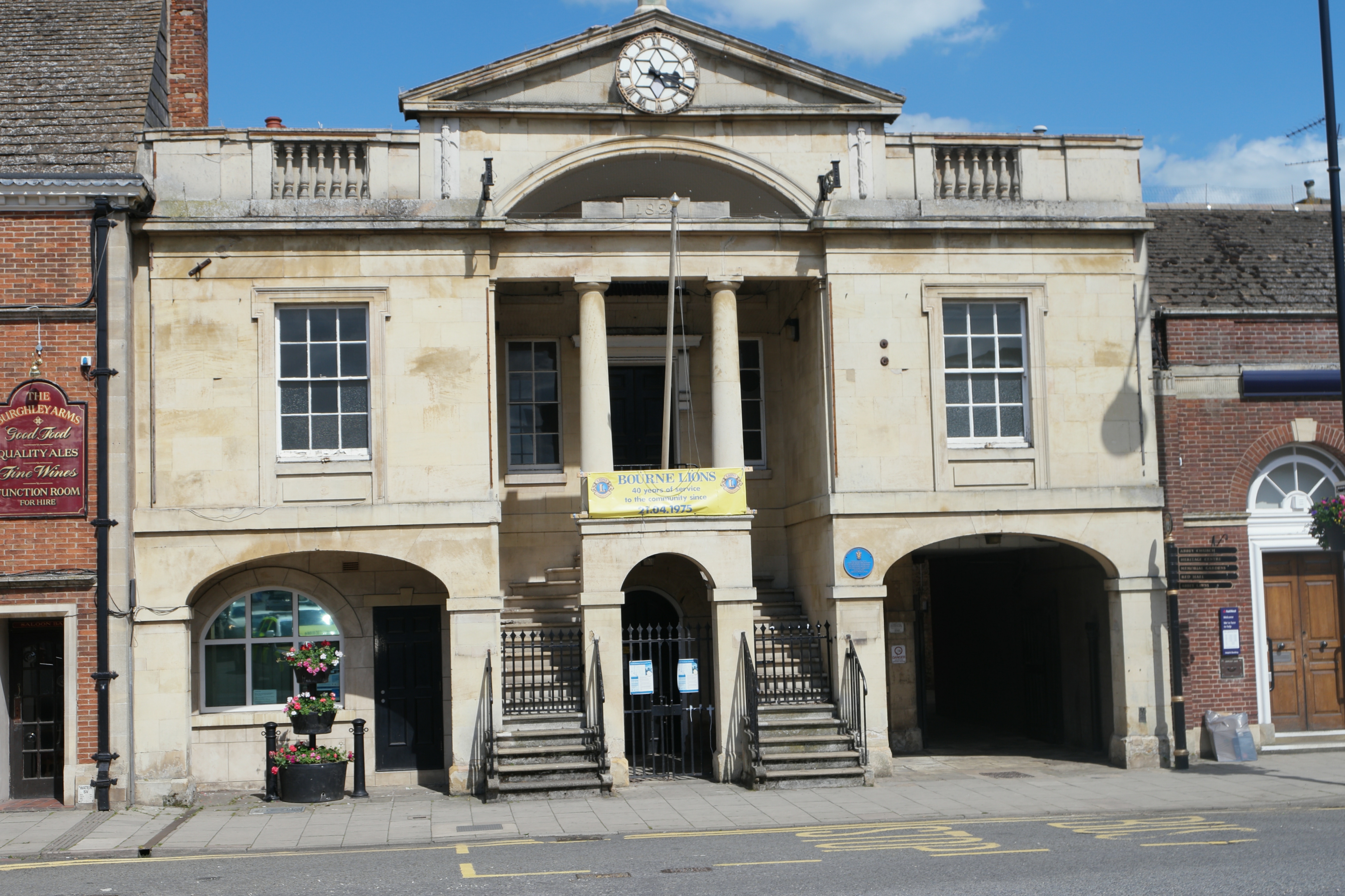
Bourne Town Hall, Lincolnshire

Bourne Town Hall is a municipal building in North Street, Bourne, Lincolnshire, England. The town hall, which was the headquarters of Bourne Urban District...

Bourne, Lincolnshire

Bourne is a market town and civil parish in the South Kesteven district of Lincolnshire, England. It lies on the eastern slopes of the limestone Kesteven...

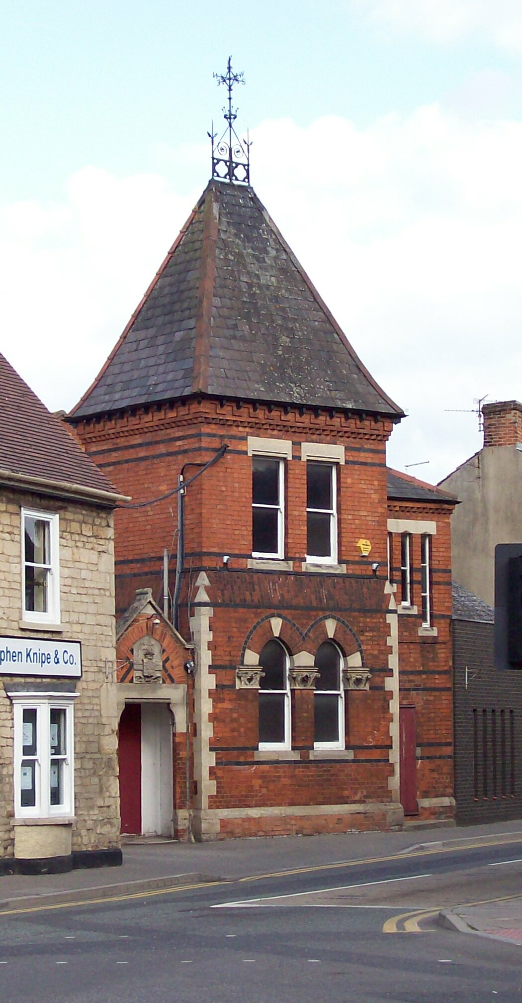
Corn Exchange, Bourne

The Corn Exchange is a commercial building in Abbey Road in Bourne, Lincolnshire, England. The structure is currently used as a community events venue...

Bourne Abbey

Bourne Abbey and the Parish Church of St. Peter and St. Paul is a scheduled Grade I church in Bourne, Lincolnshire, England. The building remains in parochial...

Nearby Amenities

Located within 500m of 52.768243,-0.37717697
Mini Roundabout
Direction: clockwise
Source: Bing
Lat/Long: 52.7678944/-0.3812252
Mini Roundabout
Direction: clockwise
Lat/Long: 52.7716131/-0.3766935
Mini Roundabout
Direction: clockwise
Lat/Long: 52.7711726/-0.3769127
Mini Roundabout
Foot: no
Lat/Long: 52.7707995/-0.3815593
Bourne
Historic Railway: station
Railway: site
Wikidata: Q4950262
Wikipedia: en:Bourne railway station
Lat/Long: 52.7644496/-0.3770035
Bourne East Junction
Historic Railway: junction
Railway: site
Lat/Long: 52.7651941/-0.3738104
Bus Station
Bourne Bus Station
Addr City: Bourne
Addr Street: North Street
Bus: yes
Naptan AtcoCode: 270GLBC00026
Operator: Delaine
Public Transport: station
Shelter: yes
Start Date: 1974-10
Lat/Long: 52.7710409/-0.3774944
Bus Stop
Town Hall
Bus: yes
Naptan AtcoCode: 270000008960
Naptan Bearing: SE
Naptan CommonName: Town Hall
Naptan Indicator: adj
Naptan Landmark: Town Hall
Naptan NaptanCode: lingwjpg
Naptan Street: Market Place
Naptan Verified: no
Public Transport: platform
Source: naptan_import
Lat/Long: 52.7682106/-0.3769967
Bus Stop
Baldwin Grove
Bus: yes
Naptan AtcoCode: 270000009538
Naptan Bearing: W
Naptan CommonName: Baldwin Grove
Naptan Indicator: adj
Naptan Landmark: Baldwin Grove
Naptan NaptanCode: linjdgjw
Naptan Street: Harrington Street
Naptan Verified: no
Public Transport: platform
Source: naptan_import
Lat/Long: 52.7715325/-0.3746792
Bus Stop
Post Office
Bus: yes
Naptan AtcoCode: 270000009546
Naptan Bearing: E
Naptan CommonName: Post Office
Naptan Indicator: o/s
Naptan Landmark: Post Office
Naptan NaptanCode: linjdgpa
Naptan Street: West Street
Naptan Verified: no
Public Transport: platform
Source: naptan_import
Lat/Long: 52.7681472/-0.3786552
Bus Stop
Sainsburys
Bus: yes
Naptan AtcoCode: 270000009555
Naptan Bearing: S
Naptan CommonName: Sainsburys
Naptan Indicator: opp
Naptan Landmark: Sainsburys
Naptan NaptanCode: linjdgtg
Naptan Street: Exeter Street
Naptan Verified: no
Public Transport: platform
Source: naptan_import
Lat/Long: 52.7697259/-0.3812985
Bus Stop
Nowells Lane
Bus: yes
Naptan AtcoCode: 270000009764
Naptan Bearing: NW
Naptan CommonName: Nowells Lane
Naptan Indicator: opp
Naptan Landmark: Nowells Lane
Naptan NaptanCode: linjdwag
Naptan Street: Spalding Road
Naptan Verified: no
Public Transport: platform
Source: naptan_import
Lat/Long: 52.7674291/-0.371832
Bus Stop
Manor Lane
Bench: yes
Bus: yes
Naptan AtcoCode: 270002701681
Naptan Bearing: W
Naptan CommonName: Manor Lane
Naptan Indicator: adj
Naptan Landmark: Manor Lane
Naptan NaptanCode: linagpag
Naptan Street: West Street
Naptan Verified: no
Network: 201
Operator: Delaine Buses
Public Transport: platform
Shelter: no
Source: naptan_import
Lat/Long: 52.7677569/-0.3832689
Bus Stop
Manor Lane
Bench: yes
Bus: yes
Naptan AtcoCode: 270002701682
Naptan Bearing: E
Naptan CommonName: Manor Lane
Naptan Indicator: opp
Naptan Landmark: Manor Lane
Naptan NaptanCode: linagpaj
Naptan Street: West Street
Naptan Verified: no
Operator: Delaine Buses
Public Transport: platform
Shelter: no
Source: naptan_import;local knowledge
Lat/Long: 52.7678458/-0.3833494
Bus Stop
Nowells Lane
Bus: yes
Naptan AtcoCode: 2700LBAP5242
Naptan Bearing: SE
Naptan CommonName: Nowells Lane
Naptan Indicator: adj
Naptan Landmark: Nowells Lane
Naptan NaptanCode: lindtawd
Naptan Street: Spalding Road
Naptan Verified: no
Public Transport: platform
Source: naptan_import
Lat/Long: 52.7676921/-0.3718981
Bus Stop
Sainsburys
Bus: yes
Naptan AtcoCode: 2700LBES6682
Naptan Bearing: N
Naptan CommonName: Sainsburys
Naptan Indicator: o/s
Naptan Landmark: Sainsburys
Naptan NaptanCode: linagpam
Naptan Street: Exeter Street
Naptan Verified: no
Public Transport: platform
Source: naptan_import
Lat/Long: 52.7697188/-0.3814463
Bus Stop
Baldwin Grove
Bus: yes
Naptan AtcoCode: 2700LBHS2203
Naptan Bearing: E
Naptan CommonName: Baldwin Grove
Naptan Indicator: opp
Naptan Landmark: Baldwin Grove
Naptan NaptanCode: linapjpj
Naptan Street: Harrington Street
Naptan Verified: no
Public Transport: platform
Source: naptan_import
Lat/Long: 52.7716067/-0.3746709
Bus Stop
Town Hall
Alt Name: Angel Hotel
Bench: no
Bus: yes
Naptan AltCommonName: Angel Hotel
Naptan AltIndicator: adj
Naptan AltLandmark: Angel Hotel
Naptan AltStreet: Market Place
Naptan AtcoCode: 2700LBMP0610
Naptan Bearing: N
Naptan CommonName: Town Hall
Naptan Indicator: opp
Naptan Landmark: Town Hall
Naptan NaptanCode: linagadj
Naptan Street: Market Place
Naptan Verified: no
Public Transport: platform
Shelter: no
Source: naptan_import
Lat/Long: 52.7685841/-0.3773534
Bus Stop
Post Office
Bus: yes
Naptan AtcoCode: 2700LBWS1132
Naptan Bearing: W
Naptan CommonName: Post Office
Naptan Indicator: opp
Naptan Landmark: Post Office
Naptan NaptanCode: linajdga
Naptan Street: West Street
Naptan Verified: no
Public Transport: platform
Source: naptan_import
Lat/Long: 52.768049/-0.3785938
Barrier: bollard
Lat/Long: 52.7695077/-0.3840905
Noexit: yes
Lat/Long: 52.7704113/-0.380509
Noexit: yes
Lat/Long: 52.7704013/-0.3807277
Noexit: yes
Lat/Long: 52.7702073/-0.3810308
Noexit: yes
Lat/Long: 52.7682857/-0.3821983
Traffic Signals
Traffic Signals: signal
Traffic Signals Direction: forward
Transport: traffic_signals
Lat/Long: 52.7679081/-0.3771787
Noexit: yes
Lat/Long: 52.7667989/-0.3820708
Crossing
Crossing: uncontrolled
Crossing Island: no
Crossing Markings: zebra
Crossing Ref: zebra
Flashing Lights: always
Kerb: lowered
Tactile Paving: yes
Traffic Calming: table
Lat/Long: 52.7679841/-0.3793504
Noexit: yes
Lat/Long: 52.7681204/-0.3826874
Entrance: main
Lat/Long: 52.7681775/-0.3792679
Noexit: yes
Lat/Long: 52.7685274/-0.379581
Entrance: main
Lat/Long: 52.768046/-0.3794748
Noexit: yes
Lat/Long: 52.7687554/-0.3785838
Crossing
Crossing: unmarked
Crossing Island: no
Crossing Markings: no
Kerb: lowered
Tactile Paving: yes
Lat/Long: 52.7678727/-0.3829166
Give Way
Direction: backward
Lat/Long: 52.7679658/-0.3812186
Crossing
Crossing: unmarked
Crossing Island: no
Crossing Markings: no
Kerb: lowered
Tactile Paving: no
Lat/Long: 52.7678329/-0.3843787
Noexit: yes
Lat/Long: 52.7699445/-0.381628
Crossing
Crossing: unmarked
Crossing Markings: no
Source: Bing
Lat/Long: 52.768863/-0.3811595
Crossing
Crossing: uncontrolled
Crossing Ref: zebra
Source: Bing
Lat/Long: 52.7694735/-0.3816883
Crossing
Crossing: unmarked
Crossing Island: no
Crossing Markings: no
Lat/Long: 52.7680252/-0.3812201
Noexit: yes
Lat/Long: 52.769473/-0.3827955
Crossing
Crossing: unmarked
Crossing Markings: no
Source: Bing
Lat/Long: 52.768653/-0.3812692
Crossing
Crossing: unmarked
Crossing Markings: no
Source: Bing
Lat/Long: 52.7683091/-0.3813064
Crossing
Crossing: unmarked
Crossing Markings: no
Source: Bing
Lat/Long: 52.7688452/-0.3813988
Crossing
Crossing: unmarked
Crossing Markings: no
Source: Bing
Lat/Long: 52.7684549/-0.3812019
Crossing
Crossing: zebra
Crossing Island: no
Crossing Ref: zebra
Source: Bing
Tactile Paving: yes
Lat/Long: 52.7690259/-0.3812968
Traffic Signals
Traffic Signals: signal
Traffic Signals Direction: forward
Transport: traffic_signals
Lat/Long: 52.768233/-0.377532
Crossing
Button Operated: yes
Crossing: traffic_signals
Crossing Ref: pelican
Kerb: lowered
Tactile Paving: yes
Transport: traffic_signals
Lat/Long: 52.7682384/-0.3774755
Give Way
Direction: backward
Lat/Long: 52.7678769/-0.3811302
Traffic Signals
Traffic Signals: signal
Traffic Signals Direction: forward
Transport: traffic_signals
Lat/Long: 52.768012/-0.3769035
Crossing
Crossing: unmarked
Crossing Markings: no
Kerb: lowered
Source: Bing
Lat/Long: 52.770119/-0.3783217
Crossing
Crossing: unmarked
Crossing Markings: no
Kerb: lowered
Source: Bing
Lat/Long: 52.770736/-0.3818277
Crossing
Crossing: unmarked
Crossing Markings: no
Kerb: lowered
Source: Bing
Lat/Long: 52.7707964/-0.3813324
Crossing
Crossing: unmarked
Crossing Markings: no
Kerb: lowered
Source: Bing
Lat/Long: 52.7703821/-0.3784962
Crossing
Crossing: unmarked
Crossing Markings: no
Kerb: lowered
Source: Bing
Lat/Long: 52.7702542/-0.3797147
Crossing
Crossing: unmarked
Crossing Island: no
Crossing Markings: no
Kerb: lowered
Source: Bing
Tactile Paving: yes
Lat/Long: 52.7700557/-0.3815988
Crossing
Crossing: unmarked
Crossing Markings: no
Kerb: lowered
Source: Bing
Lat/Long: 52.7703848/-0.3794887
Crossing
Crossing: uncontrolled
Kerb: lowered
Source: Bing
Lat/Long: 52.7705841/-0.3830366
Crossing
Crossing: unmarked
Crossing Markings: no
Kerb: lowered
Source: Bing
Lat/Long: 52.7708562/-0.3795098
Crossing
Crossing: unmarked
Crossing Markings: no
Kerb: lowered
Source: Bing
Lat/Long: 52.7702593/-0.3810331
Crossing
Crossing: unmarked
Crossing Markings: no
Kerb: lowered
Source: Bing
Lat/Long: 52.7705092/-0.38309
Crossing
Crossing: unmarked
Crossing Markings: no
Kerb: lowered
Source: Bing
Lat/Long: 52.7712424/-0.3796258
Noexit: yes
Lat/Long: 52.7697605/-0.3774319
Bourne
Description: Located on the A15 road, Bourne is a historic market town containing castle earthworks. The Abbey Church is the oldest building in the town, while other buildings such as Baldock's Mill, Austerby Manor House and the Red Hall are also historic.
Place: town
Population: 17981
Population Date: 2021-1-1
Source Population: Census
Wikidata: Q2223229
Wikipedia: en:Bourne, Lincolnshire
Lat/Long: 52.7682345/-0.3771579
Noexit: yes
Lat/Long: 52.7705564/-0.3765307
Crossing
Crossing: unmarked
Crossing Markings: no
Kerb: lowered
Lat/Long: 52.771193/-0.3771302
Crossing
Crossing: uncontrolled
Crossing Ref: zebra
Kerb: lowered
Source: Bing
Lat/Long: 52.7668912/-0.3703624
Crossing
Button Operated: yes
Crossing: traffic_signals
Crossing Island: no
Crossing Ref: pelican
Kerb: lowered
Tactile Paving: yes
Lat/Long: 52.769043/-0.377135
Crossing
Button Operated: yes
Crossing: traffic_signals
Crossing Ref: pelican
Kerb: lowered
Tactile Paving: yes
Lat/Long: 52.7680377/-0.3769496
Crossing
Button Operated: yes
Crossing: traffic_signals
Crossing Island: no
Crossing Ref: pelican
Kerb: lowered
Tactile Paving: yes
Lat/Long: 52.7679473/-0.3771745
Traffic Signals
Traffic Signals: signal
Traffic Signals Direction: backward
Lat/Long: 52.7690738/-0.3771259
Traffic Signals
Traffic Signals: signal
Traffic Signals Direction: forward
Lat/Long: 52.7690117/-0.3771469
Crossing
Crossing: unmarked
Crossing Markings: no
Kerb: lowered
Tactile Paving: yes
Lat/Long: 52.7689839/-0.3772306
Building: retail
Lat/Long: 52.7685769/-0.378725
Bourne Bridal
Addr City: Bourne
Addr Postcode: PE10 9EG
Addr Street: Burghley Centre
Phone: +44 1778 217077
Shop: clothes
Website: https://www.bournebridal.co.uk/
Lat/Long: 52.7687447/-0.3762971
Crossing
Crossing: unmarked
Crossing Markings: no
Kerb: lowered
Lat/Long: 52.771383/-0.3769069
Crossing
Crossing: unmarked
Crossing Markings: no
Kerb: lowered
Lat/Long: 52.7716205/-0.3764792
Crossing
Crossing Island: yes
Kerb: lowered
Lat/Long: 52.7717158/-0.3767161
Noexit: yes
Lat/Long: 52.7711061/-0.3776412
Crossing
Crossing: unmarked
Crossing Markings: no
Kerb: lowered
Lat/Long: 52.7716147/-0.3768366
Crossing
Crossing: unmarked
Crossing Markings: no
Kerb: lowered
Lat/Long: 52.7717747/-0.3767902
Turning Circle
Lat/Long: 52.7653307/-0.3719559
Crossing
Crossing: unmarked
Crossing Island: no
Crossing Markings: no
Kerb: lowered
Source: Bing
Tactile Paving: no
Lat/Long: 52.7712621/-0.3801764
Bourne Castle
Access: yes
Castle Type: site
Description: Bourne Castle was a Norman motte and double bailey castle. It was destroyed after being used by Oliver Cromwell's troops in 1645, and a farmhouse was built on its site
Historic: castle
Historic Civilization: medieval
Razed Historic: castle
Source: Wikipedia;local knowledge
Wikidata: Q15203997
Wikipedia: en:Bourne Castle
Lat/Long: 52.7667831/-0.3790984
Barrier: bollard
Lat/Long: 52.7680963/-0.3756665
Barrier: bollard
Lat/Long: 52.7697678/-0.3841062
Entrance: yes
Lat/Long: 52.766214/-0.3757034
Man Made: mast
Lat/Long: 52.7687577/-0.3733493
Pub
The Nags Head
Addr City: Bourne
Addr Housenumber: 2
Addr Postcode: PE10 9EF
Addr Street: Abbey Road
Fhrs Authority: South Kesteven
Fhrs Id: 238395
Fhrs Local Authority Id: 3068
Lat/Long: 52.7678957/-0.3769187
Nightclub
The Late Bar
Addr City: Bourne
Addr Housenumber: 2
Addr Postcode: PE10 9EF
Addr Street: Abbey Road
Fhrs Authority: South Kesteven
Fhrs Id: 237840
Fhrs Local Authority Id: 72944
Lat/Long: 52.7678047/-0.3769134
Crossing
Lat/Long: 52.7670022/-0.3769989
Fast Food
Subway
Addr City: Bourne
Addr Street: Burghley Centre
Brand: Subway
Brand Wikidata: Q244457
Brand Wikipedia: en:Subway (restaurant)
Contact Website: https://restaurants.subway.com/united-kingdom/en/bourne/unit-5-the-burghley-centre
Cuisine: sandwich
Takeaway: yes
Lat/Long: 52.7689434/-0.3765218
Bank
Nationwide
Atm: yes
Brand: Nationwide
Brand Wikidata: Q846735
Brand Wikipedia: en:Nationwide Building Society
Drive Through: no
Website: https://www.nationwide.co.uk/branches/bourne/17-north-street
Lat/Long: 52.7690968/-0.3772596
Restaurant
Jade Garden
Addr City: Bourne
Addr Housenumber: 41
Addr Postcode: PE10 9EN
Addr Street: Abbey Road
Fhrs Authority: South Kesteven
Fhrs Id: 238287
Fhrs Local Authority Id: 6620
Takeaway: yes
Lat/Long: 52.7677043/-0.373156
Fast Food
UK 1 Pizza and Kebab
Addr City: Bourne
Addr Housenumber: 9
Addr Postcode: PE10 9EF
Addr Street: Abbey Road
Cuisine: pizza
Drive Through: no
Fhrs Authority: South Kesteven
Fhrs Id: 1088917
Fhrs Local Authority Id: 87964
Outdoor Seating: no
Takeaway: yes
Lat/Long: 52.7677498/-0.3762698
Fast Food
Carlos Pizza
Addr City: Bourne
Addr Housenumber: 2
Addr Postcode: PE10 9LT
Addr Street: South Street
Cuisine: pizza
Fhrs Authority: South Kesteven
Fhrs Id: 238643
Fhrs Local Authority Id: 3468
Takeaway: yes
Lat/Long: 52.7678742/-0.3770602
Heron Foods
Addr City: Bourne
Addr Country: GB
Addr Housenumber: 13
Addr Postcode: PE10 9AE
Addr Street: North Street
Brand: Heron Foods
Brand Wikidata: Q5743472
Brand Wikipedia: en:Heron Foods
Contact Website: https://heronfoods.com/store/bourne/
Fhrs Authority: South Kesteven
Fhrs Id: 237546
Fhrs Local Authority Id: 73699
Shop: supermarket
Wheelchair: yes
Lat/Long: 52.7687934/-0.3773574
Crossing
Lat/Long: 52.7688311/-0.3794251
Crossing
Button Operated: yes
Crossing: traffic_signals
Tactile Paving: yes
Lat/Long: 52.7681629/-0.3773842
Traffic Signals Direction: forward
Transport: traffic_signals
Lat/Long: 52.768164/-0.3773106
Noexit: yes
Lat/Long: 52.7685243/-0.3786959
Crossing
Crossing: unmarked
Crossing Markings: no
Kerb: lowered
Lat/Long: 52.7647211/-0.3746754
Noexit: yes
Lat/Long: 52.7651326/-0.3762558
Noexit: yes
Lat/Long: 52.7654096/-0.376226
Give Way
Direction: backward
Lat/Long: 52.7658771/-0.3764721
Noexit: yes
Lat/Long: 52.766189/-0.3829016
Crossing
Lat/Long: 52.7688561/-0.3796198
Crossing
Lat/Long: 52.7688678/-0.3798779
The Beauty Bee
Contact Phone: +44 7841 259137
Opening Hours: Mo-Fr 10:00-15:00
Shop: beauty
Lat/Long: 52.7690199/-0.3796667
Generator Method: photovoltaic
Generator Output Electricity: yes
Generator Source: solar
Generator Type: solar_photovoltaic_panel
Location: roof
Power: generator
Lat/Long: 52.7717142/-0.3816889
Generator Method: photovoltaic
Generator Output Electricity: yes
Generator Source: solar
Generator Type: solar_photovoltaic_panel
Location: roof
Power: generator
Lat/Long: 52.7717169/-0.3817488
Generator Method: photovoltaic
Generator Output Electricity: yes
Generator Source: solar
Generator Type: solar_photovoltaic_panel
Location: roof
Power: generator
Lat/Long: 52.7711664/-0.381598
Generator Method: photovoltaic
Generator Output Electricity: yes
Generator Source: solar
Generator Type: solar_photovoltaic_panel
Location: roof
Power: generator
Lat/Long: 52.768147/-0.3714821
Bourne Town Council
Government: administrative
Office: government
Lat/Long: 52.7680414/-0.3760591
Library
Bourne Library
Lat/Long: 52.7680702/-0.3758144
Noexit: yes
Lat/Long: 52.768213/-0.3754535
Noexit: yes
Lat/Long: 52.7684479/-0.3763374
Cancer Research UK
Addr City: Bourne
Addr Street: Burghley Centre
Brand: Cancer Research UK
Brand Wikidata: Q326079
Brand Wikipedia: en:Cancer Research UK
Shop: charity
Lat/Long: 52.768927/-0.3764024
Age UK
Addr City: Bourne
Addr Street: Burghley Centre
Brand: Age UK
Brand Wikidata: Q4691850
Brand Wikipedia: en:Age UK
Shop: charity
Lat/Long: 52.7689862/-0.3767525
Noexit: yes
Lat/Long: 52.7686345/-0.3768691
Noexit: yes
Lat/Long: 52.768525/-0.3767605
Noexit: yes
Lat/Long: 52.7687903/-0.3768168
Noexit: yes
Lat/Long: 52.769863/-0.3762294
Noexit: yes
Lat/Long: 52.7676305/-0.3783449
Morrisons Daily
Addr City: Bourne
Addr Housenumber: 10
Addr Postcode: PE10 9NE
Addr Street: West Street
Brand: Morrisons Daily
Brand Wikidata: Q99752411
Shop: convenience
Website: https://my.morrisons.com/storefinder/60085/morrisons-daily-bourne-west-street
Lat/Long: 52.7682227/-0.3784563
Noexit: yes
Lat/Long: 52.7691351/-0.3776255
Noexit: yes
Lat/Long: 52.7693039/-0.3784664
Noexit: yes
Lat/Long: 52.7684192/-0.3796291
Entrance: yes
Lat/Long: 52.7693558/-0.3777991
Generator Method: photovoltaic
Generator Output Electricity: yes
Generator Source: solar
Generator Type: solar_photovoltaic_panel
Location: roof
Power: generator
Lat/Long: 52.7696229/-0.3842178
Generator Method: photovoltaic
Generator Output Electricity: yes
Generator Source: solar
Generator Type: solar_photovoltaic_panel
Location: roof
Power: generator
Lat/Long: 52.7696262/-0.3840006
Generator Method: photovoltaic
Generator Output Electricity: yes
Generator Source: solar
Generator Type: solar_photovoltaic_panel
Location: roof
Power: generator
Lat/Long: 52.7719018/-0.3797798
Generator Method: photovoltaic
Generator Output Electricity: yes
Generator Source: solar
Generator Type: solar_photovoltaic_panel
Location: roof
Power: generator
Lat/Long: 52.7719569/-0.3795376
Generator Method: photovoltaic
Generator Output Electricity: yes
Generator Source: solar
Generator Type: solar_photovoltaic_panel
Location: roof
Power: generator
Lat/Long: 52.7717946/-0.3802591
Generator Method: photovoltaic
Generator Output Electricity: yes
Generator Source: solar
Generator Type: solar_photovoltaic_panel
Location: roof
Power: generator
Lat/Long: 52.7716278/-0.3786103
Generator Method: photovoltaic
Generator Output Electricity: yes
Generator Source: solar
Generator Type: solar_photovoltaic_panel
Location: roof
Power: generator
Lat/Long: 52.7698665/-0.3818926
Generator Method: photovoltaic
Generator Output Electricity: yes
Generator Source: solar
Generator Type: solar_photovoltaic_panel
Location: roof
Power: generator
Lat/Long: 52.7698762/-0.3823928
Generator Method: photovoltaic
Generator Output Electricity: yes
Generator Source: solar
Generator Type: solar_photovoltaic_panel
Location: roof
Power: generator
Lat/Long: 52.7696076/-0.3823847
Generator Method: photovoltaic
Generator Output Electricity: yes
Generator Source: solar
Generator Type: solar_photovoltaic_panel
Location: roof
Power: generator
Lat/Long: 52.7696174/-0.3820723
Generator Method: photovoltaic
Generator Output Electricity: yes
Generator Source: solar
Generator Type: solar_photovoltaic_panel
Location: roof
Power: generator
Lat/Long: 52.7691699/-0.3833872
Generator Method: photovoltaic
Generator Output Electricity: yes
Generator Source: solar
Generator Type: solar_photovoltaic_panel
Location: roof
Power: generator
Lat/Long: 52.7691675/-0.3832228
Generator Method: photovoltaic
Generator Output Electricity: yes
Generator Source: solar
Generator Type: solar_photovoltaic_panel
Location: roof
Power: generator
Lat/Long: 52.7685437/-0.3838479
Generator Method: photovoltaic
Generator Output Electricity: yes
Generator Source: solar
Generator Type: solar_photovoltaic_panel
Location: roof
Power: generator
Lat/Long: 52.7689231/-0.3783386
Generator Method: photovoltaic
Generator Output Electricity: yes
Generator Source: solar
Generator Type: solar_photovoltaic_panel
Location: roof
Power: generator
Lat/Long: 52.7689239/-0.378407
Generator Method: photovoltaic
Generator Output Electricity: yes
Generator Source: solar
Generator Type: solar_photovoltaic_panel
Location: roof
Power: generator
Lat/Long: 52.7689207/-0.3785961
Generator Method: photovoltaic
Generator Output Electricity: yes
Generator Source: solar
Generator Type: solar_photovoltaic_panel
Location: roof
Power: generator
Lat/Long: 52.7689256/-0.3786793
Generator Method: photovoltaic
Generator Output Electricity: yes
Generator Source: solar
Generator Type: solar_photovoltaic_panel
Location: roof
Power: generator
Lat/Long: 52.7689126/-0.3787383
Generator Method: photovoltaic
Generator Output Electricity: yes
Generator Source: solar
Generator Type: solar_photovoltaic_panel
Location: roof
Power: generator
Lat/Long: 52.7689077/-0.3788576
Generator Method: photovoltaic
Generator Output Electricity: yes
Generator Source: solar
Generator Type: solar_photovoltaic_panel
Location: roof
Power: generator
Lat/Long: 52.7689191/-0.3789207
Generator Method: photovoltaic
Generator Output Electricity: yes
Generator Source: solar
Generator Type: solar_photovoltaic_panel
Location: roof
Power: generator
Lat/Long: 52.768902/-0.3789757
Generator Method: photovoltaic
Generator Output Electricity: yes
Generator Source: solar
Generator Type: solar_photovoltaic_panel
Location: roof
Power: generator
Lat/Long: 52.7688996/-0.3790789
Generator Method: photovoltaic
Generator Output Electricity: yes
Generator Source: solar
Generator Type: solar_photovoltaic_panel
Location: roof
Power: generator
Lat/Long: 52.7689029/-0.37915
Generator Method: photovoltaic
Generator Output Electricity: yes
Generator Source: solar
Generator Type: solar_photovoltaic_panel
Location: roof
Power: generator
Lat/Long: 52.7662279/-0.3819167
Generator Method: photovoltaic
Generator Output Electricity: yes
Generator Source: solar
Generator Type: solar_photovoltaic_panel
Location: roof
Power: generator
Lat/Long: 52.7662733/-0.3825604
Generator Method: photovoltaic
Generator Output Electricity: yes
Generator Source: solar
Generator Type: solar_photovoltaic_panel
Location: roof
Power: generator
Lat/Long: 52.7642591/-0.3763446
Generator Method: photovoltaic
Generator Output Electricity: yes
Generator Source: solar
Generator Type: solar_photovoltaic_panel
Location: roof
Power: generator
Lat/Long: 52.7648504/-0.3736549
Generator Method: photovoltaic
Generator Output Electricity: yes
Generator Source: solar
Generator Type: solar_photovoltaic_panel
Location: roof
Power: generator
Lat/Long: 52.7652286/-0.3725793
Generator Method: photovoltaic
Generator Output Electricity: yes
Generator Source: solar
Generator Type: solar_photovoltaic_panel
Location: roof
Power: generator
Lat/Long: 52.765541/-0.3731935
Generator Method: photovoltaic
Generator Output Electricity: yes
Generator Source: solar
Generator Type: solar_photovoltaic_panel
Location: roof
Power: generator
Lat/Long: 52.7655467/-0.373101
Generator Method: photovoltaic
Generator Output Electricity: yes
Generator Source: solar
Generator Type: solar_photovoltaic_panel
Location: roof
Power: generator
Lat/Long: 52.7711948/-0.3737166
Generator Method: photovoltaic
Generator Output Electricity: yes
Generator Source: solar
Generator Type: solar_photovoltaic_panel
Location: roof
Power: generator
Lat/Long: 52.7716625/-0.3749155
Generator Method: photovoltaic
Generator Output Electricity: yes
Generator Source: solar
Generator Type: solar_photovoltaic_panel
Location: roof
Power: generator
Lat/Long: 52.7716641/-0.3749638
Noexit: yes
Lat/Long: 52.768675/-0.3734825
Noexit: yes
Lat/Long: 52.7692699/-0.3730747
Noexit: yes
Lat/Long: 52.769649/-0.377697
Spice of Life
Addr City: Bourne
Addr Postcode: PE10 9EG
Addr Street: Burghley Centre
Addr Unit: 4 The Burghley Centre
Fhrs Authority: South Kesteven
Fhrs Id: 238488
Fhrs Local Authority Id: 3152
Shop: health_food
Website: https://www.yell.com/biz/spice-of-life-bourne-1511947/
Lat/Long: 52.7689617/-0.3766176
Noexit: yes
Lat/Long: 52.7708701/-0.378076
Ford: yes
Lat/Long: 52.7647791/-0.3789057
Noexit: yes
Lat/Long: 52.7656507/-0.3766612
Noexit: yes
Lat/Long: 52.7648414/-0.3730576
Noexit: yes
Lat/Long: 52.764299/-0.3741445
Noexit: yes
Lat/Long: 52.7646609/-0.3743096
Crossing
Crossing: unmarked
Crossing Island: no
Crossing Markings: no
Tactile Paving: no
Lat/Long: 52.7695584/-0.3810111
Noexit: yes
Lat/Long: 52.7638975/-0.3758537
Argos
Addr City: Bourne
Addr Housename: Sainsbury's
Addr Postcode: PE10 9NJ
Addr Street: Exeter Street
Brand: Argos
Brand Wikidata: Q4789707
Brand Wikipedia: en:Argos (retailer)
Contact Website: https://www.argos.co.uk/stores/4476-bourne-argos-in-sainsburys
Fhrs Authority: South Kesteven
Fhrs Id: 975053
Fhrs Local Authority Id: 87415
Shop: catalogue
Lat/Long: 52.7695633/-0.3826958
Crossing
Lat/Long: 52.7712794/-0.3768205
Crossing
Lat/Long: 52.7712869/-0.3768942
Crossing
Lat/Long: 52.7702913/-0.3768642
Crossing
Lat/Long: 52.7680863/-0.3784092
Bench
Material: wood
Lat/Long: 52.7669042/-0.3773906
Bench: yes
Leisure: picnic_table
Lit: no
Material: wood
Lat/Long: 52.7668365/-0.3778187
Noexit: yes
Lat/Long: 52.7673414/-0.3773246
Entrance: yes
Lat/Long: 52.7663156/-0.3758978
Noexit: yes
Lat/Long: 52.7713794/-0.3783227
Noexit: yes
Lat/Long: 52.7677553/-0.3780385
Telephone
Defibrillator
Booth: KX100
Covered: booth
Defibrillator Location: inside phone box (next to post box) at junction of West Street and North Street, Bourne
Emergency: defibrillator
Man Made: telephone_box
Ref GB The Circuit: 703894A3-E780-4B28-B03F-ADF300ABA3B6
Lat/Long: 52.7683134/-0.3774179
Post Box
Collection Times: Mo-Fr 09:00; Sa 07:00
Post Box Design: type_c
Post Box Type: pillar
Lat/Long: 52.7683143/-0.3773908
Board Type: notice
Information: board
Tourism: information
Lat/Long: 52.7683539/-0.3774259
Bench
Backrest: yes
Lat/Long: 52.768349/-0.3773961
Bicycle Parking
Bicycle Parking: stands
Capacity: 8
Covered: no
Lat/Long: 52.7683904/-0.377157
Noexit: yes
Lat/Long: 52.7670473/-0.381595
Noexit: yes
Lat/Long: 52.766782/-0.381805
Noexit: yes
Lat/Long: 52.7701275/-0.3781207
Give Way
Direction: forward
Lat/Long: 52.7678752/-0.3813497
Noexit: yes
Lat/Long: 52.7719684/-0.3754327
Noexit: yes
Lat/Long: 52.7721499/-0.3756083
Noexit: yes
Lat/Long: 52.7710069/-0.3724526
Noexit: yes
Lat/Long: 52.7711069/-0.3720081
Noexit: yes
Lat/Long: 52.7710262/-0.3721806
Noexit: yes
Lat/Long: 52.7701374/-0.3804366
Noexit: yes
Lat/Long: 52.7655506/-0.3725292
Historic: memorial
Material: metal
Memorial: plaque
Lat/Long: 52.7652635/-0.3745793
Bench
Lat/Long: 52.765255/-0.374647
Noexit: yes
Lat/Long: 52.7654436/-0.3745439
Noexit: yes
Lat/Long: 52.7700134/-0.3796507
Noexit: yes
Lat/Long: 52.7689973/-0.3811467
Raymond Mays Memorial
Historic: memorial
Material: metal
Memorial: plaque
Lat/Long: 52.7661/-0.3768323
Noexit: yes
Lat/Long: 52.7672341/-0.3762328
Noexit: yes
Lat/Long: 52.7674554/-0.3777153
Noexit: yes
Lat/Long: 52.7671136/-0.3778239
Noexit: yes
Lat/Long: 52.7647835/-0.3760495
Pub
The Raymond Mays
Addr City: Bourne
Addr Housenumber: 44-48
Addr Street: North Street
Brand: Wetherspoon
Brand Wikidata: Q6109362
Fhrs Authority: South Kesteven
Fhrs Id: 1452419
Fhrs Local Authority Id: 87811
Opening Hours: Mo-Th 08:00-24:00; Fr-Sa 08:00-01:00; Su 08:00-24:00
Toilets Wheelchair: yes
Website: https://www.jdwetherspoon.com/pubs/all-pubs/england/lincolnshire/the-raymond-mays
Wheelchair: yes
Lat/Long: 52.7698186/-0.3768126
Noexit: yes
Lat/Long: 52.7705673/-0.3829139
Noexit: yes
Lat/Long: 52.7708868/-0.3772468
Entrance: main
Lat/Long: 52.7714992/-0.3772723
Noexit: yes
Lat/Long: 52.765191/-0.3721033
Noexit: yes
Lat/Long: 52.7649687/-0.3723573
Noexit: yes
Lat/Long: 52.7646683/-0.3759621
Noexit: yes
Lat/Long: 52.7693011/-0.3738807
Noexit: yes
Lat/Long: 52.7652398/-0.3767343
Almshouses
Place: neighbourhood
Lat/Long: 52.7674961/-0.3838739
Height: 0.1
Waterway: weir
Lat/Long: 52.7655281/-0.3728527
Noexit: yes
Lat/Long: 52.7661253/-0.3760012
Noexit: yes
Lat/Long: 52.7681784/-0.3823975
Noexit: yes
Lat/Long: 52.7679558/-0.3824184
Restaurant
Il Mulino
Addr City: Bourne
Addr Housenumber: 42
Addr Postcode: PE10 9AB
Addr Street: North Street
Fhrs Authority: South Kesteven
Fhrs Id: 1515376
Fhrs Local Authority Id: 89368
Lat/Long: 52.7697348/-0.3768289
Bar
Newton's Wine Bar & Tapas
Addr City: Bourne
Addr Housenumber: 40
Addr Postcode: PE10 9AB
Addr Street: North Street
Fhrs Authority: South Kesteven
Fhrs Id: 1005255
Fhrs Local Authority Id: 87467
Lat/Long: 52.7696423/-0.3768531
Restaurant
China Hand
Addr City: Bourne
Addr Housenumber: 36
Addr Postcode: PE10 9AB
Addr Street: North Street
Fhrs Authority: South Kesteven
Fhrs Id: 238214
Fhrs Local Authority Id: 3365
Toilets Wheelchair: yes
Wheelchair: yes
Lat/Long: 52.7695619/-0.3768799
Harrison & Dunn
Shop: houseware
Lat/Long: 52.7694905/-0.3768839
Jason Anthony & Co
Shop: hairdresser
Lat/Long: 52.7694183/-0.3769201
Nettl
Office: it
Lat/Long: 52.7693875/-0.3769295
Bodrum Barbers
Shop: hairdresser
Lat/Long: 52.7693526/-0.3769349
Bar
The Jubilee Garage
Addr City: Bourne
Addr Housenumber: 30
Addr Postcode: PE10 9AB
Addr Street: North Street
Fhrs Authority: South Kesteven
Fhrs Id: 237569
Fhrs Local Authority Id: 10591
Wheelchair: no
Lat/Long: 52.7692439/-0.3769496
My.Lab
Shop: hairdresser
Lat/Long: 52.7691627/-0.3769778
North Shoes
Shop: shoes
Wheelchair: yes
Lat/Long: 52.7687976/-0.3770636
Cafe
Costa
Addr City: Bourne
Addr Housename: The Burghley Centre
Addr Postcode: PE10 9EG
Addr Street: Hereward Street
Addr Unit: Unit 1
Brand: Costa
Brand Wikidata: Q608845
Brand Wikipedia: en:Costa Coffee
Cuisine: coffee_shop
Fhrs Id: 238282
Opening Hours: 08:00 - 17:30
Source: bing
Takeaway: yes
Toilets Wheelchair: yes
Wheelchair: yes
Lat/Long: 52.7690435/-0.3769844
Dentist
North Street Dental Practice
Healthcare: dentist
Lat/Long: 52.7708326/-0.3767699
Fast Food
Hot & Spice
Addr City: Bourne
Addr Housenumber: 64
Addr Postcode: PE10 9AJ
Addr Street: North Street
Fhrs Authority: South Kesteven
Fhrs Id: 237837
Fhrs Local Authority Id: 11598
Lat/Long: 52.7705697/-0.3767672
Gerber Beauty
Shop: beauty
Lat/Long: 52.7705088/-0.3767712
Kudos
Shop: hairdresser
Lat/Long: 52.7701827/-0.3768075
Ha's Nails
Shop: beauty
Lat/Long: 52.7701453/-0.3768088
Cafe
Cafe 35
Addr City: Bourne
Addr Housenumber: 35c
Addr Postcode: PE10 9AE
Addr Street: North Street
Fhrs Authority: South Kesteven
Fhrs Id: 448136
Fhrs Local Authority Id: 84905
Shop: charity
Lat/Long: 52.769682/-0.3771628
Rosedale
Office: estate_agent
Lat/Long: 52.7686524/-0.3770904
Cafe
Don't Lose Hope
Addr City: Bourne
Addr Housenumber: 4
Addr Postcode: PE10 9EB
Addr Street: North Street
Fhrs Authority: South Kesteven
Fhrs Id: 1128450
Fhrs Local Authority Id: 88110
Lat/Long: 52.7681744/-0.3768638
Newton Fallowell
Office: estate_agent
Lat/Long: 52.7681176/-0.3768316
Quentin Marks
Office: estate_agent
Lat/Long: 52.768297/-0.3775504
Three Counties Dog Rescue
Shop: charity
Lat/Long: 52.7688877/-0.3773157
Leaders
Brand: Leaders
Brand Wikidata: Q111522674
Office: estate_agent
Lat/Long: 52.7689266/-0.3772996
Dani's
Shop: clothes
Lat/Long: 52.7689615/-0.3772943
Card Factory
Brand: Card Factory
Brand Wikidata: Q5038192
Shop: gift
Lat/Long: 52.7690467/-0.3772675
Bourne Bookshop
Shop: books
Lat/Long: 52.7691928/-0.3772165
Blush Bridal
Shop: clothes
Lat/Long: 52.7692487/-0.3772084
Butterfly Hospice
Shop: charity
Lat/Long: 52.7693185/-0.3772031
Pub
Smiths of Bourne
Addr City: Bourne
Addr Housenumber: 25
Addr Postcode: PE10 9AE
Addr Street: North Street
Fhrs Authority: South Kesteven
Fhrs Id: 238374
Fhrs Local Authority Id: 7674
Lat/Long: 52.769437/-0.377187
British Red Cross
Brand: British Red Cross
Brand Wikidata: Q4970966
Shop: charity
Lat/Long: 52.7695214/-0.3771856
Chya Hair Stylist
Shop: hairdresser
Lat/Long: 52.7695684/-0.3771937
Hoppers Jewellers
Shop: jewelry
Lat/Long: 52.769626/-0.3771696
Clarabelles
Shop: gift
Lat/Long: 52.7696496/-0.3771628
Greetings
Addr City: Bourne
Addr Postcode: PE10 9EG
Addr Street: Hereward Street
Addr Unit: Unit 8, The Burghley Centre
Fhrs Authority: South Kesteven
Fhrs Id: 237749
Fhrs Local Authority Id: 3156
Shop: gift
Lat/Long: 52.7688065/-0.3764065
Palmers
Shop: hairdresser
Lat/Long: 52.7677987/-0.3766908
Restaurant
Shalimar
Addr City: Bourne
Addr Housenumber: 8
Addr Postcode: PE10 9EF
Addr Street: Abbey Road
Fhrs Authority: South Kesteven
Fhrs Id: 238051
Fhrs Local Authority Id: 3080
Lat/Long: 52.7676681/-0.3765097
Cafe
Thr Abbey Road Kitchen
Lat/Long: 52.7675999/-0.3763381
Fast Food
Domino's
Addr City: Bourne
Addr Housenumber: 18
Addr Postcode: PE10 9EF
Addr Street: Abbey Road
Brand: Domino's
Brand Wikidata: Q839466
Cuisine: pizza
Fhrs Authority: South Kesteven
Fhrs Id: 1543966
Fhrs Local Authority Id: 90018
Takeaway: yes
Lat/Long: 52.7674847/-0.3754744
Sam's Convenience Store
Addr City: Bourne
Addr Housenumber: 39
Addr Postcode: PE10 9EN
Addr Street: Abbey Road
Brand: Premier
Brand Wikidata: Q7240340
Fhrs Authority: South Kesteven
Fhrs Id: 238557
Fhrs Local Authority Id: 3108
Shop: convenience
Website: https://www.premier-stores.co.uk/our-stores/sams-bourne
Lat/Long: 52.7677265/-0.3736116
T R Carlton
Shop: funeral_directors
Lat/Long: 52.7677411/-0.3737363
Fast Food
Golden Bridge
Addr City: Bourne
Addr Housenumber: 35a
Addr Postcode: PE10 9EW
Addr Street: Abbey Road
Fhrs Authority: South Kesteven
Fhrs Id: 1044872
Fhrs Local Authority Id: 87360
Lat/Long: 52.7677054/-0.3738785
Cafe
Nannys
Addr City: Bourne
Addr Housenumber: 23a
Addr Postcode: PE10 9EP
Addr Street: Abbey Road
Fhrs Authority: South Kesteven
Fhrs Id: 1427245
Fhrs Local Authority Id: 89573
Lat/Long: 52.7677379/-0.3749299
Santos Print
Shop: copyshop
Lat/Long: 52.7677363/-0.3757091
Fast Food
Zorba 2
Addr City: Bourne
Addr Housenumber: 13
Addr Postcode: PE10 9EF
Addr Street: Abbey Road
Fhrs Authority: South Kesteven
Fhrs Id: 238348
Fhrs Local Authority Id: 7092
Lat/Long: 52.7677322/-0.3758955
Clinic
The Wellhead Practice
Healthcare: clinic
Lat/Long: 52.7677281/-0.3760189
Cafe
Ginger Fox Cafe
Addr City: Bourne
Addr Housenumber: 11
Addr Postcode: PE10 9EF
Addr Street: Abbey Road
Fhrs Authority: South Kesteven
Fhrs Id: 237839
Fhrs Local Authority Id: 9470
Lat/Long: 52.767729/-0.3761476
Stephen Knipe & Co
Office: estate_agent
Lat/Long: 52.7680292/-0.3767444
Inspire Travel by Shaun
Shop: travel_agency
Lat/Long: 52.7680706/-0.3768061
Restaurant
China Palace
Addr City: Bourne
Addr Housenumber: 11b
Addr Postcode: PE10 9LY
Addr Street: South Street
Fhrs Authority: South Kesteven
Fhrs Id: 238830
Fhrs Local Authority Id: 3477
Lat/Long: 52.7675366/-0.3772567
Restaurant
Sassi's
Addr City: Bourne
Addr Housenumber: 7
Addr Postcode: PE10 9LY
Addr Street: South Street
Fhrs Authority: South Kesteven
Fhrs Id: 585474
Fhrs Local Authority Id: 85727
Lat/Long: 52.767621/-0.3772742
Bourne to Vape
Shop: e-cigarette
Lat/Long: 52.7677152/-0.3772916
Don't Lose Hope
Shop: charity
Lat/Long: 52.7677736/-0.377297
L H Hair Design
Shop: hairdresser
Lat/Long: 52.7679472/-0.377301
Mod N Ink
Shop: tattoo
Lat/Long: 52.767974/-0.3772956
Fenland Carpets
Shop: carpet
Lat/Long: 52.7680706/-0.377301
Cafe
The Little Teapot
Addr City: Bourne
Addr Housenumber: 27
Addr Postcode: PE10 9HQ
Addr Street: Wherry's Lane
Fhrs Authority: South Kesteven
Fhrs Id: 1200499
Fhrs Local Authority Id: 71447
Lat/Long: 52.7689357/-0.3787952
Barber's Chop
Shop: hairdresser
Lat/Long: 52.7678296/-0.3770556
Bar
Bar 1888
Addr City: Bourne
Addr Housenumber: 6
Addr Postcode: PE10 9LT
Addr Street: South Street
Fhrs Authority: South Kesteven
Fhrs Id: 1341602
Fhrs Local Authority Id: 89123
Lat/Long: 52.7677882/-0.3770462
M & Arc Hair & Beauty
Shop: hairdresser
Lat/Long: 52.7675448/-0.3770193
Pub
Red Lion Public House
Addr City: Bourne
Addr Housenumber: 14
Addr Postcode: PE10 9LT
Addr Street: South Street
Fhrs Authority: South Kesteven
Fhrs Id: 238008
Fhrs Local Authority Id: 3484
Lat/Long: 52.7673216/-0.3769308
Cafe
Starbucks
Addr City: Bourne
Addr Housename: J Sainsbury
Addr Postcode: PE10 9NJ
Addr Street: Exeter Street
Brand: Starbucks
Brand Wikidata: Q37158
Cuisine: coffee_shop
Fhrs Authority: South Kesteven
Fhrs Id: 1515379
Fhrs Local Authority Id: 89798
Official Name: Starbucks Coffee
Takeaway: yes
Website: https://www.starbucks.com/store-locator/store/1033878/bourne-sainsburys-cafe-sainsbury-15-exeter-street-bourne-eng-pe-10-9-nw-g
Lat/Long: 52.7694832/-0.3821813
Pharmacy
Well Pharmacy
Addr City: Bourne
Addr Postcode: PE10 9NJ
Addr Street: Exeter Street
Brand: Well Pharmacy
Brand Wikidata: Q7726524
Dispensing: yes
Fhrs Authority: South Kesteven
Fhrs Id: 850003
Fhrs Local Authority Id: 60222
Healthcare: pharmacy
Website: https://finder.well.co.uk/store/bourne-hereward-mc
Lat/Long: 52.7683262/-0.3811272
One Stop Eyecare Centre
Shop: optician
Lat/Long: 52.7682929/-0.3776215
Coral
Addr City: Bourne
Addr Housenumber: 2
Addr Postcode: PE10 9NE
Addr Street: West Street
Brand: Coral
Brand Wikidata: Q54621344
Fhrs Authority: South Kesteven
Fhrs Id: 238771
Fhrs Local Authority Id: 3578
Shop: bookmaker
Lat/Long: 52.7682807/-0.3777409
Double & Megson Solicitors
Office: lawyer
Lat/Long: 52.7682856/-0.3779461
Winkworth
Brand: Winkworth
Brand Wikidata: Q8025502
Office: estate_agent
Lat/Long: 52.7682499/-0.378111
Scrivens
Brand: Scrivens
Brand Wikidata: Q79424133
Shop: optician
Lat/Long: 52.7682329/-0.3782907
Moore & Scrupps
Shop: jewelry
Lat/Long: 52.7681704/-0.3787789
The End
Shop: hairdresser
Lat/Long: 52.7681095/-0.3791262
Clinic
Pulse Practice
Healthcare: clinic
Lat/Long: 52.76803/-0.3797096
Markey's Wee Barber Shop
Shop: hairdresser
Lat/Long: 52.7679115/-0.3794052
Restaurant
The Leaf
Addr City: Bourne
Addr Housenumber: 35
Addr Postcode: PE10 9NB
Addr Street: West Street
Cuisine: indian
Fhrs Authority: South Kesteven
Fhrs Local Authority Id: 85808
Takeaway: yes
Toilets: yes
Toilets Access: customers
Lat/Long: 52.7679326/-0.3791302
Eckfords
Office: estate_agent
Lat/Long: 52.7679837/-0.3788084
Illusions Tattoo
Shop: tattoo
Lat/Long: 52.7679967/-0.3787293
Dentist
Bourne Dental Practice
Healthcare: dentist
Lat/Long: 52.7680267/-0.3785643
The Cutting Room
Shop: hairdresser
Lat/Long: 52.7680706/-0.3783149
Bourne Funeralcare
Shop: funeral_directors
Lat/Long: 52.7680844/-0.3781687
Sally Annes
Shop: charity
Lat/Long: 52.7681055/-0.3780359
Superdrug
Addr City: Bourne
Addr Housenumber: 9
Addr Postcode: PE10 9NB
Addr Street: West Street
Brand: Superdrug
Brand Wikidata: Q7643261
Fhrs Authority: South Kesteven
Fhrs Id: 238438
Fhrs Local Authority Id: 3589
Shop: chemist
Lat/Long: 52.7681241/-0.3779018
Bourne Nails
Shop: beauty
Lat/Long: 52.7680811/-0.3773546
Mobile World
Shop: mobile_phone
Lat/Long: 52.7680787/-0.3773251
Noexit: yes
Lat/Long: 52.7699557/-0.3780673
Noexit: yes
Lat/Long: 52.7699728/-0.3777407
Noexit: yes
Lat/Long: 52.7704645/-0.3780346
Noexit: yes
Lat/Long: 52.7708204/-0.3774041
Noexit: yes
Lat/Long: 52.7707807/-0.3778066
Noexit: yes
Lat/Long: 52.7704387/-0.3772175
Noexit: yes
Lat/Long: 52.769265/-0.3787377
Waste Basket
Lat/Long: 52.7688586/-0.3797452
Noexit: yes
Lat/Long: 52.7687093/-0.3779086
Waste Basket
Lat/Long: 52.7700886/-0.3781792
Noexit: yes
Lat/Long: 52.7709643/-0.3809924
Noexit: yes
Lat/Long: 52.7682254/-0.3810622
Barrier: bollard
Lat/Long: 52.7653382/-0.3721499
Waste Basket
Lat/Long: 52.7681753/-0.3785126
Waste Basket
Lat/Long: 52.771503/-0.3740984
Waste Basket
Lat/Long: 52.7719071/-0.3729459
Bench
Lat/Long: 52.771946/-0.3730393
Waste Basket
Lat/Long: 52.7715474/-0.3754628
Waste Basket
Lat/Long: 52.7716843/-0.3758566
Waste Basket
Lat/Long: 52.7716697/-0.3768445
Barrier: kerb
Lat/Long: 52.7644642/-0.3762666
Noexit: yes
Lat/Long: 52.7685006/-0.3724813
Traffic Signals
Traffic Signals: signal
Traffic Signals Direction: backward
Transport: traffic_signals
Lat/Long: 52.7683927/-0.3772447
Waste Basket
Lat/Long: 52.7674943/-0.3762034
Noexit: yes
Lat/Long: 52.7638588/-0.3761643
Noexit: yes
Lat/Long: 52.763849/-0.376307
Noexit: yes
Lat/Long: 52.7664334/-0.3762463
Barrier: block
Foot: yes
Motor Vehicle: no
Lat/Long: 52.7668167/-0.3783017
Noexit: yes
Lat/Long: 52.770171/-0.38157
Noexit: yes
Lat/Long: 52.7701592/-0.3820185
Access: private
Entrance: main
Lat/Long: 52.7648384/-0.3767846
Noexit: yes
Lat/Long: 52.7638675/-0.3773246
Noexit: yes
Lat/Long: 52.7699077/-0.3782196
Noexit: yes
Lat/Long: 52.7714452/-0.3746746
Noexit: yes
Lat/Long: 52.7712407/-0.3749321
Marketplace
Bourne Market
Addr City: Bourne
Addr Street: Market Place
Image: https://s1.geograph.org.uk/geophotos/06/63/04/6630489_4d2c1918_1024x1024.jpg
Note: main market is on thursday, market on saturday is smaller
Opening Hours: Th 08:30-16:00; Sa 08:30-16:00
Website: https://www.southkesteven.gov.uk/index.aspx?articleid=8636
Lat/Long: 52.7683694/-0.3759477
Entrance: yes
Lat/Long: 52.765348/-0.3747631
Barrier: block
Foot: yes
Motor Vehicle: no
Lat/Long: 52.7669452/-0.3777434
Noexit: yes
Lat/Long: 52.765283/-0.3764114
Waste Basket
Colour: #000000
Lat/Long: 52.7710337/-0.3772831
Waste Basket
Colour: #000000
Lat/Long: 52.7710283/-0.3772788
Bench
Backrest: yes
Lat/Long: 52.7710818/-0.3772761
Bench
Backrest: yes
Lat/Long: 52.7711161/-0.3772695
Advertising: board
Lat/Long: 52.7710981/-0.377287
Noexit: yes
Lat/Long: 52.7708644/-0.3772073
Give Way
Direction: forward
Lat/Long: 52.7712442/-0.3768333
Waste Basket
Colour: #000000
Material: metal
Lat/Long: 52.7711464/-0.3770951
Man Made: planter
Material: metal
Lat/Long: 52.7710993/-0.3772724
Man Made: planter
Material: metal
Lat/Long: 52.7710597/-0.3771937
Access: private
Entrance: yes
Lat/Long: 52.765601/-0.3731265
Access: private
Entrance: main
Lat/Long: 52.7655052/-0.3731648
A1 Motor Spares
Addr City: Bourne
Addr Postcode: PE10 9EG
Addr Street: Burghley Centre
Contact Facebook: https://www.facebook.com/people/A1-motor-stores-Bourne-Ltd/100087151082341/
Phone: +44 1778 218738
Shop: vehicle_parts
Lat/Long: 52.7689148/-0.3770183
Entrance: main
Lat/Long: 52.7659662/-0.3760074
Atm
Currency GBP: yes
Drive Through: no
Lat/Long: 52.7694757/-0.3819968
Post Office
Bourne Post Office
Addr City: Bourne
Addr Housenumber: 31
Addr Postcode: PE10 9NB
Addr Street: West Street
Brand: Post Office
Brand Wikidata: Q1783168
Opening Hours: Mo-Fr 09:00-17:30; Sa 09:00-13:00
Operator: Post Office Ltd
Ref Pol Id: 147958
Website: https://www.postoffice.co.uk/branch-finder/4282302/bourne
Wheelchair: yes
Lat/Long: 52.7679452/-0.3789609
Noexit: yes
Lat/Long: 52.7693902/-0.3748622
Barrier: kerb
Kerb: raised
Lat/Long: 52.7696966/-0.3733878
Barrier: kerb
Kerb: lowered
Lat/Long: 52.7678175/-0.3747368
Bourne Outdoor Swimming Pool
Addr City: Bourne
Addr Housename: Bourne Outdoor Swimming Pool
Addr Postcode: PE10 9LN
Addr Street: Coggles Causeway
Leisure: sports_centre
Sport: swimming
Lat/Long: 52.7658732/-0.3731001
Addr City: Bourne
Addr Housenumber: 35b
Addr Street: West Street
Lat/Long: 52.767922/-0.3792692
Noexit: yes
Lat/Long: 52.7723385/-0.3783607
Car Wash
Bourne Station Garage
Addr City: Bourne
Addr Street: South Street
Automated: no
Payment Cash: yes
Self Service: no
Lat/Long: 52.7654669/-0.3754442
Give Way
Direction: forward
Lat/Long: 52.7692986/-0.3814117
Give Way
Direction: backward
Lat/Long: 52.7690117/-0.3818735
Give Way
Direction: forward
Lat/Long: 52.7690706/-0.3823877
Give Way
Direction: forward
Lat/Long: 52.7690723/-0.3821495
Give Way
Direction: forward
Lat/Long: 52.7690774/-0.3819075
Give Way
Direction: backward
Lat/Long: 52.7693556/-0.3824044
Give Way
Direction: backward
Lat/Long: 52.7693801/-0.3821625
Give Way
Direction: backward
Lat/Long: 52.7693845/-0.3819256
Give Way
Direction: backward
Lat/Long: 52.7700598/-0.381475
Give Way
Direction: backward
Lat/Long: 52.7705532/-0.3769944
Give Way
Direction: forward
Lat/Long: 52.7710886/-0.3769177
Give Way
Direction: backward
Lat/Long: 52.7647285/-0.3746372
Noexit: yes
Lat/Long: 52.7694532/-0.3750462
Addr Housenumber: 20
Addr Street: North Street
Addr Town: Bourne
Historic Building: house
Note: demolished to make room for Maple Gardens
Lat/Long: 52.7726363/-0.3762476
Noexit: yes
Lat/Long: 52.770465/-0.3750972
Noexit: yes
Lat/Long: 52.7679954/-0.3745325
Noexit: yes
Lat/Long: 52.7714941/-0.3814885
Noexit: yes
Lat/Long: 52.771538/-0.3816591
Noexit: yes
Lat/Long: 52.7716138/-0.3811699
Noexit: yes
Lat/Long: 52.7692397/-0.3782772
Noexit: yes
Lat/Long: 52.7654765/-0.3720069
Camera Mount: pole
Camera Type: dome
Man Made: surveillance
Surveillance: outdoor
Surveillance Type: camera
Lat/Long: 52.7683579/-0.3771423
Camera Direction: 150
Camera Mount: pole
Camera Type: dome
Man Made: surveillance
Surveillance: outdoor
Surveillance Type: camera
Lat/Long: 52.7673111/-0.3771775
Camera Direction: 65
Camera Mount: pole
Camera Type: dome
Man Made: surveillance
Surveillance: outdoor
Surveillance Type: camera
Lat/Long: 52.76756/-0.3747407
Camera Mount: pole
Camera Type: dome
Man Made: surveillance
Surveillance: outdoor
Surveillance Type: camera
Lat/Long: 52.7685681/-0.3756025
Camera Mount: ceiling
Camera Type: dome
Man Made: surveillance
Surveillance: outdoor
Surveillance Type: camera
Lat/Long: 52.768994/-0.377075
Camera Mount: pole
Camera Type: dome
Man Made: surveillance
Surveillance: outdoor
Surveillance Type: camera
Lat/Long: 52.7711377/-0.3771227
Camera Mount: pole
Camera Type: dome
Man Made: surveillance
Surveillance: outdoor
Surveillance Type: camera
Lat/Long: 52.7703075/-0.376834
Camera Direction: 50
Camera Mount: wall
Camera Type: dome
Man Made: surveillance
Surveillance: outdoor
Surveillance Type: camera
Lat/Long: 52.7679687/-0.379083
Noexit: yes
Lat/Long: 52.7679311/-0.3736928
Noexit: yes
Lat/Long: 52.7684295/-0.3735335
Man Made: planter
Lat/Long: 52.7651044/-0.3745763
Entrance: yes
Lat/Long: 52.7680228/-0.3823356
Noexit: yes
Lat/Long: 52.7719184/-0.3809229
Noexit: yes
Lat/Long: 52.7715493/-0.3806858
Noexit: yes
Lat/Long: 52.7683155/-0.3729397
Noexit: yes
Lat/Long: 52.7683088/-0.3726259
Addr City: Bourne
Addr Housename: The Corn Mill
Addr Housenumber: 1,2,3,4,5,6
Addr Postcode: PE10 9GN
Addr Street: South Street
Lat/Long: 52.7665775/-0.3766547
Addr City: Bourne
Addr Housename: The Corn Mill
Addr Housenumber: 7
Addr Postcode: PE10 9GN
Addr Street: South Street
Lat/Long: 52.7666951/-0.3766639
Addr City: Bourne
Addr Housename: The Corn Mill
Addr Housenumber: 8
Addr Postcode: PE10 9GN
Addr Street: South Street
Lat/Long: 52.7667319/-0.3766705
Addr City: Bourne
Addr Housename: The Corn Mill
Addr Housenumber: 8
Addr Postcode: PE10 9GN
Addr Street: South Street
Lat/Long: 52.7667671/-0.3766771
Addr City: Bourne
Addr Housename: The Corn Mill
Addr Housenumber: 9
Addr Postcode: PE10 9GN
Addr Street: South Street
Lat/Long: 52.7668023/-0.3766824
Addr City: Bourne
Addr Housename: The Corn Mill
Addr Housenumber: 10
Addr Postcode: PE10 9GN
Addr Street: South Street
Lat/Long: 52.7668408/-0.376693
Noexit: yes
Lat/Long: 52.7666514/-0.3764166
Noexit: yes
Lat/Long: 52.77199/-0.3732361
Noexit: yes
Lat/Long: 52.7711397/-0.3754165
Noexit: yes
Lat/Long: 52.7710212/-0.3742023
Noexit: yes
Lat/Long: 52.7710974/-0.3739806
Noexit: yes
Lat/Long: 52.7712687/-0.3736766
Noexit: yes
Lat/Long: 52.7710058/-0.3732908
Noexit: yes
Lat/Long: 52.7709967/-0.3731991
Noexit: yes
Lat/Long: 52.7714167/-0.3739724
Entrance: yes
Lat/Long: 52.7681361/-0.3759541
Post Box
Collection Times: Mo-Fr 09:00; Sa 07:00
Operator: Royal Mail
Post Box Mounting: pier
Post Box Type: lamp
Ref: PE10 203
Lat/Long: 52.7678888/-0.3825635
The data included in this document is from www.openstreetmap.org. The data is made available under ODbL.

Have you been to Bourne?

Leave your review of Bourne below (or comments, questions and feedback).