Trevenning

Settlement in Cornwall

England

Trevenning

Fishing from Gam Bridge The bridge spans the River Camel.
Fishing from Gam Bridge Credit: John Baker

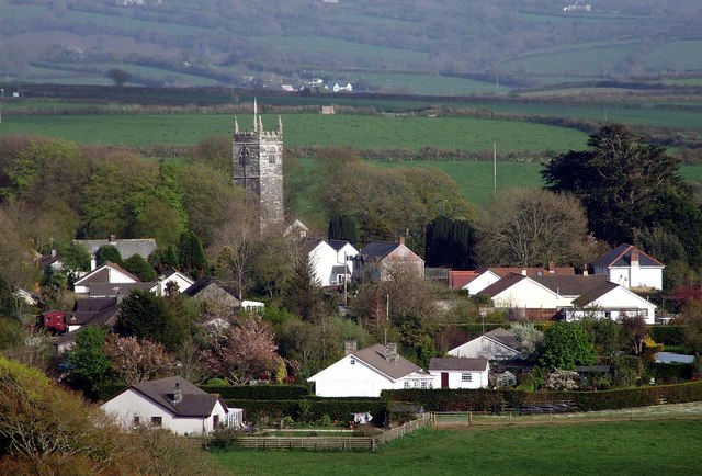
Trevenning is a small village located in the county of Cornwall, England. It is situated near the town of St. Austell and is known for its picturesque countryside and charming atmosphere. The village is surrounded by rolling hills, lush green fields, and quaint cottages, providing a peaceful and tranquil setting for residents and visitors alike.

Trevenning has a rich history, with evidence of settlement dating back to the medieval period. The village is home to a number of historic buildings, including a church dating back to the 12th century, as well as a traditional village pub that has been serving locals for generations.

In addition to its historical charm, Trevenning offers a range of outdoor activities for nature enthusiasts, including hiking, cycling, and birdwatching. The village is also within easy reach of the stunning coastline of Cornwall, with its sandy beaches and rugged cliffs.

Overall, Trevenning is a hidden gem in the heart of Cornwall, offering a peaceful retreat for those looking to escape the hustle and bustle of modern life and immerse themselves in the beauty of the English countryside.

If you have any feedback on the listing, please let us know in the comments section below.
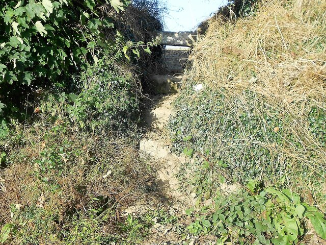
Trevenning Images

Images are sourced within 2km of 50.565397/-4.719595 or Grid Reference SX0777. Thanks to Geograph Open Source API. All images are credited.

Fishing from Gam Bridge The bridge spans the River Camel.
Fishing from Gam Bridge
The bridge spans the River Camel.
Stone Stile SX0676a Between Recreation Field and Glebe Parc. Section of footpath from village to Wetherham House.
A granite cattle type stile with gap under top stone.                                                    
One step either side of stile.  The land is slightly lower on Glebe Parc side of stile.  
Height 0.65m Recreation side, 0.45m Glebe Parc side. Width 0.85m. Usage Good. 
Public footpath 551/2/1 (gold) Michaels Cottage to Wetherham Lane.
Stone Stile SX0676a
Between Recreation Field and Glebe Parc. Section of footpath from village to Wetherham House. A granite cattle type stile with gap under top stone. One step either side of stile. The land is slightly lower on Glebe Parc side of stile. Height 0.65m Recreation side, 0.45m Glebe Parc side. Width 0.85m. Usage Good. Public footpath 551/2/1 (gold) Michaels Cottage to Wetherham Lane.
Stone Stile SX0676b Between Glebe Parc and footpath to Wetherham Lane.
A granite cattle stile.  Only top stone clear but gap is obstructed by a large bolder.  Two steps up to the top stone on both sides.  The land is slightly lower on the Maenne Parc footpath side.
Height 0.6m Glebe Parc side, 0.8m Maenne Parc footpath. Width 1.3m at top. 0.5m at base. Usage Good. 
Public footpath 551/2/1 (gold) Michaels Cottage to Wetherham Lane.
Stone Stile SX0676b
Between Glebe Parc and footpath to Wetherham Lane. A granite cattle stile. Only top stone clear but gap is obstructed by a large bolder. Two steps up to the top stone on both sides. The land is slightly lower on the Maenne Parc footpath side. Height 0.6m Glebe Parc side, 0.8m Maenne Parc footpath. Width 1.3m at top. 0.5m at base. Usage Good. Public footpath 551/2/1 (gold) Michaels Cottage to Wetherham Lane.
Stone Stile SX0676c Between footpath from Glebe Parc and Wetherham Lane.
A granite cattle stile. One step up on footpath side.  Four steps up from Wetherham Lane.  Land lower on Wetherham Lane side.
Height 0.85m Maenne Parc footpath, 1.6m Wetherham Lane side. Width 1m.
Usage Difficult due to height from road
Public footpath 551/2/1 (gold) Michaels Cottage to Wetherham Lane.
Stone Stile SX0676c
Between footpath from Glebe Parc and Wetherham Lane. A granite cattle stile. One step up on footpath side. Four steps up from Wetherham Lane. Land lower on Wetherham Lane side. Height 0.85m Maenne Parc footpath, 1.6m Wetherham Lane side. Width 1m. Usage Difficult due to height from road Public footpath 551/2/1 (gold) Michaels Cottage to Wetherham Lane.
Stone Stile SX0676d Adjacent to North-West end of Recreation Field.
Very low stile missing top stone and side banks. One step on village side and two on other side.  The ground slightly lower on the far side.  
Height 0.3m on village side, 0.45m on west side. Width 0.60m.
Public footpath 551/2/3 (gold) West end of New Cemetery to Tremeer cross-path.
Stone Stile SX0676d
Adjacent to North-West end of Recreation Field. Very low stile missing top stone and side banks. One step on village side and two on other side. The ground slightly lower on the far side. Height 0.3m on village side, 0.45m on west side. Width 0.60m. Public footpath 551/2/3 (gold) West end of New Cemetery to Tremeer cross-path.
Stone Stile SX0676e North-East corner of Fairview House field.
A granite cattle stile with only a gap under the top stone.  Two steps up from both sides.  The land is slightly lower on the side away from the village.   
Height 0.95m on village side, 1.15m on west side. Width 1.5m top stone.
Public footpath 551/2/3 (gold) West end of New Cemetery to Tremeer cross-path.
Stone Stile SX0676e
North-East corner of Fairview House field. A granite cattle stile with only a gap under the top stone. Two steps up from both sides. The land is slightly lower on the side away from the village. Height 0.95m on village side, 1.15m on west side. Width 1.5m top stone. Public footpath 551/2/3 (gold) West end of New Cemetery to Tremeer cross-path.
Stone Stile SX0676f Bottom of Tremeer Valley.
Slate-on-edge pedestrian stile.  Adjacent to footbridge / boardwalk over Tremeer Stream.  One step on side nearest village.  Three steps on side away from village.
Height 0.8m on village side, 1.35m on west side. Width 1m slate stone.
Public footpath 551/2/3 (gold) West end of New Cemetery to Tremeer cross-path.
Stone Stile SX0676f
Bottom of Tremeer Valley. Slate-on-edge pedestrian stile. Adjacent to footbridge / boardwalk over Tremeer Stream. One step on side nearest village. Three steps on side away from village. Height 0.8m on village side, 1.35m on west side. Width 1m slate stone. Public footpath 551/2/3 (gold) West end of New Cemetery to Tremeer cross-path.
Stone Stile SX0676g Between Oke Cottage and Haypark Corner.
A granite sheep stile.  Two remaining steps on village side.  Four small steps on side away from village.  The land is lower on the side away from village.   
Height 0.90m on St Tudy side, 2.65m on Haypark Corner side. Width 0.80m
Usage: Very difficult - overgrown & very high
Public footpath 551/5/1 (gold) Oke Cottage to Haypark Corner.
Stone Stile SX0676g
Between Oke Cottage and Haypark Corner. A granite sheep stile. Two remaining steps on village side. Four small steps on side away from village. The land is lower on the side away from village. Height 0.90m on St Tudy side, 2.65m on Haypark Corner side. Width 0.80m Usage: Very difficult - overgrown & very high Public footpath 551/5/1 (gold) Oke Cottage to Haypark Corner.
Stone Stile SX0676h Bottom of valley between St Tudy and Tregooden Farm.
A granite sheep stile near bottom of valley between Church Town and Tregooden Farm. 
In very poor condition.  High hedges arching over stile.  Approached on village side via a wooden stile with a top rail hinged upwards.  Steps are missing on the wall.  Only one step left and almost impossible to climb up or down.
Height 1.20m stone wall. Downward slope towards Tregooden Farm.
Stone Stile SX0676h
Bottom of valley between St Tudy and Tregooden Farm. A granite sheep stile near bottom of valley between Church Town and Tregooden Farm. In very poor condition. High hedges arching over stile. Approached on village side via a wooden stile with a top rail hinged upwards. Steps are missing on the wall. Only one step left and almost impossible to climb up or down. Height 1.20m stone wall. Downward slope towards Tregooden Farm.
Stone Stile SX0676i Bottom of valley between St Tudy and Tregooden Farm.
Slate-on-edge pedestrian stile at bottom of valley adjacent to stream.  No step on village side.  One step on Tregooden Farm side.   
Height 0.60m St Tudy side, 1.00m on Tregooden Farm side.
Width 1.4m wide at top of vertical slate.
Public footpath 551/6/1 (gold) Elm Cottage to B3266
Stone Stile SX0676i
Bottom of valley between St Tudy and Tregooden Farm. Slate-on-edge pedestrian stile at bottom of valley adjacent to stream. No step on village side. One step on Tregooden Farm side. Height 0.60m St Tudy side, 1.00m on Tregooden Farm side. Width 1.4m wide at top of vertical slate. Public footpath 551/6/1 (gold) Elm Cottage to B3266
Stone Stile SX0676j Between Hengar Lane roadside and Barn Field.
A granite coffen stile with added top granite horizontal stone.  Four steps up from road.  Only coffen step on field side.  The land is lower on road side of stile.
Height 0.80m road side, 0.80m on Barn field side. Width 0.80m.
Public footpath 551/7/1 (silver) Hengar Lane to B3266.
Coffen stile – a stile built over a pit – like a granite cattle grid.
Coffen is a Cornish word for a man-made hole in the ground.
Stone Stile SX0676j
Between Hengar Lane roadside and Barn Field. A granite coffen stile with added top granite horizontal stone. Four steps up from road. Only coffen step on field side. The land is lower on road side of stile. Height 0.80m road side, 0.80m on Barn field side. Width 0.80m. Public footpath 551/7/1 (silver) Hengar Lane to B3266. Coffen stile – a stile built over a pit – like a granite cattle grid. Coffen is a Cornish word for a man-made hole in the ground.
Stone Stile SX0776a Between Barn Field and Christmas Tree field.
A granite cattle stile with gap under top stone only.  Two steps Barn Field side.  
One step on Christmas Tree Field side.  Land lower on Christmas Tree field side.
Height 1.2m Barn field side, 0.9m on Christmas Tree field side.
Width 0.90m Top, 0.40m Bottom.
Public footpath 551/7/1 (silver) Hengar Lane to B3266.
Stone Stile SX0776a
Between Barn Field and Christmas Tree field. A granite cattle stile with gap under top stone only. Two steps Barn Field side. One step on Christmas Tree Field side. Land lower on Christmas Tree field side. Height 1.2m Barn field side, 0.9m on Christmas Tree field side. Width 0.90m Top, 0.40m Bottom. Public footpath 551/7/1 (silver) Hengar Lane to B3266.
Stone Stile SX0776b Between Christmas Tree field and Bungalow field.
A granite stile with no gaps between steps and top stone.                                    Three steps each side.  Ground nearly level on each side
Height 1m on Christmas Tree field side, 1.1m on Bungalow field side. Width 0.7m.
Public footpath 551/7/1 (silver) Hengar Lane to B3266.
Stone Stile SX0776b
Between Christmas Tree field and Bungalow field. A granite stile with no gaps between steps and top stone. Three steps each side. Ground nearly level on each side Height 1m on Christmas Tree field side, 1.1m on Bungalow field side. Width 0.7m. Public footpath 551/7/1 (silver) Hengar Lane to B3266.
Stone Stile SX0776d Between roadside field and B3266.
A granite cattle stile. One step each side.  Land lower on field side.  
Height 0.90m Field side, 0.60m Road side. Width 0.60m
Public footpath 551/7/1 (silver) Hengar Lane to B3266.
Stone Stile SX0776d
Between roadside field and B3266. A granite cattle stile. One step each side. Land lower on field side. Height 0.90m Field side, 0.60m Road side. Width 0.60m Public footpath 551/7/1 (silver) Hengar Lane to B3266.
Stone Stile SX0776e B3266 to bottom of valley to East of Tregarrick Farm. The only stile on a public footpath across Tregarrick Farm.
A granite cattle stile with a gap under the top stone only.  One step on West side.  Five steps on East side.  Land lower East side.    
Height 0.65m west side, 1.75m east side. Width 0.60m.
Public footpath 551/7/2 (silver) B3266 east of Tregarrick Farm.
Stone Stile SX0776e
B3266 to bottom of valley to East of Tregarrick Farm. The only stile on a public footpath across Tregarrick Farm. A granite cattle stile with a gap under the top stone only. One step on West side. Five steps on East side. Land lower East side. Height 0.65m west side, 1.75m east side. Width 0.60m. Public footpath 551/7/2 (silver) B3266 east of Tregarrick Farm.
Stone Stile SX0776c Between Bungalow Field and roadside field.
Remains only of a possible granite cattle stile. High hedge each side, meeting at the top. A metal pedestrian gate exists on the Bungalow Field side.                                             
Public footpath 551/7/1 (silver) Hengar Lane to B3266.
Stone Stile SX0776c
Between Bungalow Field and roadside field. Remains only of a possible granite cattle stile. High hedge each side, meeting at the top. A metal pedestrian gate exists on the Bungalow Field side. Public footpath 551/7/1 (silver) Hengar Lane to B3266.
St Tudy Methodist Church
North Cornwall : The B3266 The B3266 near Trevenning in North Cornwall.
North Cornwall : The B3266
The B3266 near Trevenning in North Cornwall.
Show me another place!

Trevenning is located at Grid Ref: SX0777 (Lat: 50.565397, Lng: -4.719595)

Unitary Authority: Cornwall

Police Authority: Devon and Cornwall

What 3 Words

///riches.gifted.branched. Near Delabole, Cornwall

Nearby Locations

Trevenning

Related Wikis

Fentonadle

Fentonadle is a hamlet situated 4 miles (6.4 km) south-west from Camelford in Cornwall, England. Fentonadle lies at around 120 metres (390 ft) above sea...

Gam, Cornwall

Gam is a hamlet in the parish of St Breward (where the 2011 census population is included), Cornwall, England. == References ==

St Tudy

St Tudy (Cornish: Eglostudi) is a civil parish and village in north Cornwall, England, United Kingdom. The village is situated in the River Camel valley...

Michaelstow

Michaelstow (Cornish: Logmighal (village) and Cornish: Pluwvighal yn Trygordh (parish)) is a civil parish and village in north Cornwall, England, United...

Nearby Amenities

Located within 500m of 50.565397,-4.719595
Power: tower
Lat/Long: 50.56687/-4.7224042
Power: tower
Lat/Long: 50.5646484/-4.723756
Power: tower
Lat/Long: 50.5690234/-4.7210095
Barrier: stile
Lat/Long: 50.5624615/-4.7226344
Give Way
Lat/Long: 50.5652316/-4.7212997
Give Way
Lat/Long: 50.5659822/-4.7148664
Power: pole
Lat/Long: 50.5673789/-4.7132394
Power: pole
Lat/Long: 50.5668453/-4.713005
Power: pole
Lat/Long: 50.5662676/-4.7127294
Historic: milestone
Wikidata: Q17645771
Lat/Long: 50.5652184/-4.7213983
The data included in this document is from www.openstreetmap.org. The data is made available under ODbL.

Have you been to Trevenning?

Leave your review of Trevenning below (or comments, questions and feedback).