Tressady

Settlement in Sutherland

Scotland

Tressady

Loch Airighe Mhor The loch viewed from the track that passes by.
Loch Airighe Mhor Credit: Alastair Harkiss

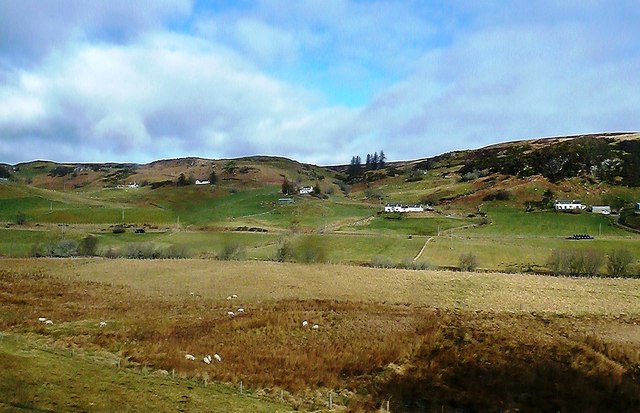
Tressady is a small hamlet located in the county of Sutherland, Scotland. Situated in the northern part of the country, Tressady is surrounded by beautiful landscapes and is known for its picturesque charm. The hamlet is nestled amidst rolling hills, lush green meadows, and dense woodlands, offering residents and visitors a tranquil and idyllic setting.

Tressady is renowned for its rich history, dating back several centuries. The area is home to Tressady House, an impressive Georgian mansion that stands as a testament to the region's past. The house is surrounded by well-manicured gardens and offers stunning views of the surrounding countryside.

Despite its small size, Tressady has a close-knit community that takes great pride in preserving its heritage. The hamlet has a few local amenities, including a church and a community center, where residents can gather for various activities and events.

The natural beauty of Tressady makes it a popular destination for outdoor enthusiasts. The surrounding area offers ample opportunities for hiking, cycling, and exploring the countryside. The nearby River Fleet provides a perfect spot for fishing, with its abundance of salmon and trout.

Tressady is also conveniently located near other attractions in Sutherland. Visitors can easily access the stunning coastline, with its rugged cliffs and sandy beaches, or explore the nearby towns and villages, each with their own unique charm.

Overall, Tressady offers a peaceful retreat from the hustle and bustle of city life, with its scenic landscapes and rich history making it a truly special place to visit or call home.

If you have any feedback on the listing, please let us know in the comments section below.

Tressady Images

Images are sourced within 2km of 58.005823/-4.2184544 or Grid Reference NC6904. Thanks to Geograph Open Source API. All images are credited.

Loch Airighe Mhor The loch viewed from the track that passes by.
Loch Airighe Mhor
The loch viewed from the track that passes by.
A lone tree at Loch Airighe Mhor A dead tree by the water's edge.
A lone tree at Loch Airighe Mhor
A dead tree by the water's edge.
Farm Buildings at Achvrail, Strath Fleet, Sutherland The hill in the background is Creag a' Mhuilleir.
Farm Buildings at Achvrail, Strath Fleet, Sutherland
The hill in the background is Creag a' Mhuilleir.
Old Shed near Inchcape, Strath Fleet, Sutherland
Strath Fleet at Acheilidh, Sutherland Strath Fleet is a valley in the northern Scottish Highlands.  The road in the bottom is the A839 Mound to Lairg road.
Strath Fleet at Acheilidh, Sutherland
Strath Fleet is a valley in the northern Scottish Highlands. The road in the bottom is the A839 Mound to Lairg road.
Muie, Strath Fleet, Sutherland View from besides the A839 Mound to Lairg road.
Muie, Strath Fleet, Sutherland
View from besides the A839 Mound to Lairg road.
Retired horse at Lettie One of five horses loose to roam over the area.
Retired horse at Lettie
One of five horses loose to roam over the area.
Lettie River Quiet at this time, but the banks show evidence of heavy Winter floods.
Lettie River
Quiet at this time, but the banks show evidence of heavy Winter floods.
Small unnamed moorland burn
Ruined crofthouse of Corryachvrail
Croft at Muie
Croft at Muie
Towards Muie A late-March view of Strath Fleet showing cultivated fields in the valley floor and moorland on the hills.  Viewed looking towards Muie from a train headed for Rogart. The buildings are in the next square.
Towards Muie
A late-March view of Strath Fleet showing cultivated fields in the valley floor and moorland on the hills. Viewed looking towards Muie from a train headed for Rogart. The buildings are in the next square.
In Strath Fleet A late-March view of Strath Fleet showing cultivated fields in the valley floor and moorland on the hills.  Viewed near Ardachu from a train between Lairg and Rogart. The buildings and the hills are in the next square.
In Strath Fleet
A late-March view of Strath Fleet showing cultivated fields in the valley floor and moorland on the hills. Viewed near Ardachu from a train between Lairg and Rogart. The buildings and the hills are in the next square.
Strath Fleet View A late-March view of Strath Fleet showing cultivated fields in the valley floor and moorland on the hills. Viewed from a train between Lairg and Rogart. The land on the other side of the A839 is in the next square.
Strath Fleet View
A late-March view of Strath Fleet showing cultivated fields in the valley floor and moorland on the hills. Viewed from a train between Lairg and Rogart. The land on the other side of the A839 is in the next square.
Towards Blarich A late-March view of Strath Fleet showing cultivated fields in the valley floor.  Viewed looking towards Blarich, in the next square on the other side of the A839, from a train between Lairg and Rogart.
Towards Blarich
A late-March view of Strath Fleet showing cultivated fields in the valley floor. Viewed looking towards Blarich, in the next square on the other side of the A839, from a train between Lairg and Rogart.
View from A839
View from A839
A839 westbound
A839 westbound
A839 westbound
A839 westbound
Show me another place!

Tressady is located at Grid Ref: NC6904 (Lat: 58.005823, Lng: -4.2184544)

Unitary Authority: Highland

Police Authority: Highlands and Islands

What 3 Words

///variety.briskly.detective. Near Lairg, Highland

Nearby Locations

Tressady Wood Tressady

Related Wikis

Ardachu

Ardachu (Scottish Gaelic: Àrd Achadh) is a village within the area of Rogart, Sutherland in the Scottish Highlands, within the Highland Council area. It...

Muie

Muie (Scottish Gaelic: A' Mhuigh) is a remote village, situated in eastern Sutherland, Scottish Highlands and is in the Scottish council area of Highland...

Battle of Torran Dubh

The Battle of Torran Dubh also known as the Battle of Torran-dow or the Battle of Torran Du was a Scottish clan battle that was fought in 1517 in Sutherland...

Rogart railway station

Rogart railway station is a railway station serving the villages of Rogart and Pittentrail, in the Highland council area of Scotland and home to Fraser...

Nearby Amenities

Located within 500m of 58.005823,-4.2184544
Bus Stop
Blarich Bridge
Local Ref: AT
Naptan AtcoCode: 6700712447
Naptan Bearing: E
Naptan CommonName: Blarich Bridge
Naptan Indicator: at
Naptan Landmark: Bridge
Naptan NaptanCode: 45327845
Naptan Street: A839
Naptan Verified: no
Source: naptan_import
Lat/Long: 58.0068414/-4.2101962
Power: pole
Lat/Long: 58.0045817/-4.2160494
Power: pole
Lat/Long: 58.0043943/-4.223874
Power: pole
Lat/Long: 58.0044151/-4.2257438
Power: pole
Lat/Long: 58.0043764/-4.2221698
Power: pole
Lat/Long: 58.0043446/-4.2203245
Power: pole
Lat/Long: 58.004528/-4.2175396
Power: pole
Lat/Long: 58.0044187/-4.2192469
Power: pole
Lat/Long: 58.0043622/-4.212482
Power: pole
Lat/Long: 58.0044711/-4.2142066
Power: pole
Lat/Long: 58.0042204/-4.2108677
Blarich
Name Gd: Blàrach
Place: hamlet
Lat/Long: 58.0080528/-4.2131358
Rossal
Name Gd: Rosal
Place: hamlet
Lat/Long: 58.0016064/-4.2197447
Ford: yes
Lat/Long: 58.0046231/-4.2240776
Creag Bhlàrach
Natural: peak
Lat/Long: 58.0100492/-4.2178837
Railway: level_crossing
Lat/Long: 58.0037053/-4.216161
The data included in this document is from www.openstreetmap.org. The data is made available under ODbL.

Have you been to Tressady?

Leave your review of Tressady below (or comments, questions and feedback).