Boswinger

Settlement in Cornwall

England

Boswinger

Coast path at the Bulwark The bank is obscured by tall bracken. You get a much better idea from <a href="https://www.geograph.org.uk/photo/4457128">SX0039 : Path junction near the Bulwark on Dodman Point</a>, taken at the same spot. But this image does include Bow (or is it Vault) Beach in the background. The bulwark is the northern earthwork enclosing cliff castle <span class="nowrap"><a title="https://www.historicengland.org.uk/listing/the-list/list-entry/1020865" rel="nofollow ugc noopener" href="https://www.historicengland.org.uk/listing/the-list/list-entry/1020865">Link</a><img style="margin-left:2px;" alt="External link" title="External link - shift click to open in new window" src="https://s1.geograph.org.uk/img/external.png" width="10" height="10"/></span>
Coast path at the Bulwark Credit: Derek Harper

Boswinger is a small village located in the parish of Gorran on the south coast of Cornwall, England. Situated near the popular tourist destinations of Mevagissey and St Austell, Boswinger offers a tranquil and picturesque setting for visitors and residents alike.

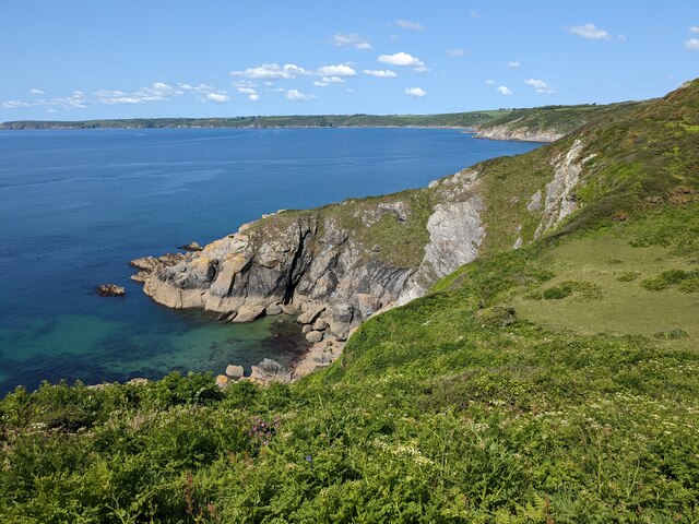
Surrounded by stunning natural beauty, Boswinger is known for its sweeping cliff-top views and rugged coastline. The village is nestled within an Area of Outstanding Natural Beauty, making it a haven for outdoor enthusiasts and nature lovers. The nearby South West Coast Path provides excellent opportunities for hiking and exploring the scenic surroundings.

The village itself is characterized by charming stone cottages and traditional Cornish architecture. It boasts a close-knit community, with a small number of local amenities including a village hall and a church. The village hall often hosts various events and gatherings, fostering a strong sense of community spirit.

Boswinger is also home to the renowned Boswinger National Nature Reserve, which is managed by the Cornwall Wildlife Trust. This nature reserve is famed for its diverse range of flora and fauna, including rare orchids and various bird species. It offers visitors the chance to experience Cornwall's natural wonders up close and personal.

Overall, Boswinger is a hidden gem in Cornwall, offering a peaceful retreat for those seeking a break from the hustle and bustle of everyday life. Its idyllic setting, combined with its natural beauty and strong community spirit, make it a truly special place to visit or call home.

If you have any feedback on the listing, please let us know in the comments section below.

Boswinger Images

Images are sourced within 2km of 50.235661/-4.816483 or Grid Reference SW9941. Thanks to Geograph Open Source API. All images are credited.

Coast path at the Bulwark The bank is obscured by tall bracken. You get a much better idea from <a href="https://www.geograph.org.uk/photo/4457128">SX0039 : Path junction near the Bulwark on Dodman Point</a>, taken at the same spot. But this image does include Bow (or is it Vault) Beach in the background. The bulwark is the northern earthwork enclosing cliff castle <span class="nowrap"><a title="https://www.historicengland.org.uk/listing/the-list/list-entry/1020865" rel="nofollow ugc noopener" href="https://www.historicengland.org.uk/listing/the-list/list-entry/1020865">Link</a><img style="margin-left:2px;" alt="External link" title="External link - shift click to open in new window" src="https://s1.geograph.org.uk/img/external.png" width="10" height="10"/></span>
Coast path at the Bulwark
The bank is obscured by tall bracken. You get a much better idea from SX0039 : Path junction near the Bulwark on Dodman Point, taken at the same spot. But this image does include Bow (or is it Vault) Beach in the background. The bulwark is the northern earthwork enclosing cliff castle LinkExternal link
Cattle south of Penare From a footpath that follows the bulwark around the Dodman cliff castle to link the coast path northwest and northnortheast of the point.
Cattle south of Penare
From a footpath that follows the bulwark around the Dodman cliff castle to link the coast path northwest and northnortheast of the point.
Trig pillar and Watch House, Dodman Point
Near Dodman Point Looking towards Bow or Vault Beach.
Near Dodman Point
Looking towards Bow or Vault Beach.
View to the coast from the path to Dodman Point
Dodman Trig Point Flush Bracket S1748 and Watch Tower
Gell Point
Gell Point
Stone Cross, Dodman Point
Cross at Dodman Point
Dodman Meadow The meadow land on the Dodman promontory covers the site of an ancient hillfort. In the distance are the hills of the St Austell Granite.
Dodman Meadow
The meadow land on the Dodman promontory covers the site of an ancient hillfort. In the distance are the hills of the St Austell Granite.
The cross at Dodman Point
On Dodman Point View to the east from Dodman Point.
On Dodman Point
View to the east from Dodman Point.
Looking along the SWC towards Boswinger
Coast path looking west, at the west end of Vault Beach
Dodman Point: the cross, and view out to sea
Path to Dodman Point The footpath from Penare to Dodman Point at the point where it crosses the bank known as the bulwark, possibly an old defensive line from the fort on Dodman Point.
Path to Dodman Point
The footpath from Penare to Dodman Point at the point where it crosses the bank known as the bulwark, possibly an old defensive line from the fort on Dodman Point.
Dodman Point A kissing gate on the South West Coast Path with a view of the Vault beach and Manease point in the background.
Dodman Point
A kissing gate on the South West Coast Path with a view of the Vault beach and Manease point in the background.
Dodman Point The South West Coast Path running along the top of the cliffs on the east side of Dodman Point. Maenease point can be seen in the background.
Dodman Point
The South West Coast Path running along the top of the cliffs on the east side of Dodman Point. Maenease point can be seen in the background.
Show me another place!

Boswinger is located at Grid Ref: SW9941 (Lat: 50.235661, Lng: -4.816483)

Unitary Authority: Cornwall

Police Authority: Devon and Cornwall

What 3 Words

///playfully.explains.hospitals. Near Mevagissey, Cornwall

Nearby Locations

Boswinger

Related Wikis

Boswinger

Boswinger is a village in south Cornwall, England, two miles south of Mevagissey (where the 2011 Census population is included). There is a youth hostel...

Hemmick Beach

Hemmick Beach is a west-facing beach on the south coast of Cornwall, England. It is situated at the east end of Veryan Bay, on the west side of the Dodman...

St Goran

St Goran is a coastal civil parish in Cornwall, England, UK, six miles (10 km) south-southwest of St Austell. The largest settlement in the parish is the...

Penare

Penare is a hamlet near Gorran Haven in Cornwall, England, UK. Penare is situated 1 mile (2 km) south-west of Gorran Haven.Pronunciation is PEA - NAR....

Nearby Amenities

Located within 500m of 50.235661,-4.816483
Source: PGS
Lat/Long: 50.2316621/-4.8190848
Passing Place
Image: https://archive.org/details/porthluney-photos/Porthluney%20to%20Hemmick%20Beach%202020-08-26/DSCN2000.JPG
Lat/Long: 50.2373571/-4.821521
Boswinger
Is In: Cornwall, England, UK
Name Kw: Boswynngor
Place: hamlet
Wikidata: Q4948364
Lat/Long: 50.2359207/-4.8182443
Bus Stop
Seaview
Bus: yes
Naptan AtcoCode: 0800COY38624
Naptan Bearing: SW
Naptan CommonName: Seaview
Naptan NaptanCode: cordgtmg
Naptan Street: Unclassified
Naptan Verified: no
Public Transport: platform
Source: naptan_import
Lat/Long: 50.236073/-4.8182419
Give Way
Lat/Long: 50.2372196/-4.8191582
Addr City: St Austell
Addr Country: GB
Addr Hamlet: Boswinger
Addr Place: Seaview International Holiday Park
Addr Postcode: PL26 6LL
Shop: convenience
Lat/Long: 50.2371184/-4.8193933
Telephone
Lat/Long: 50.2368802/-4.8193827
Cafe
Sea Breeze Cafe
Addr City: St Austell
Addr Country: GB
Addr Hamlet: Boswinger
Addr Place: Seaview International Holiday Park
Addr Postcode: PL26 6LL
Fhrs Id: 1061393
Source: Bing
Lat/Long: 50.2370798/-4.8194895
Recycling
Source: Bing
Lat/Long: 50.2367016/-4.8179928
Bbq
Lat/Long: 50.2369912/-4.8196018
Fast Food
Source: Bing
Lat/Long: 50.2370601/-4.8193851
Bbq
Lat/Long: 50.2369023/-4.8222521
Travesson
Place: hamlet
Source: OS_OpenData_StreetView
Lat/Long: 50.2377773/-4.8121349
Madam Bray
Place: locality
Source: OS_OpenData_StreetView
Lat/Long: 50.2323564/-4.8185676
Barrier: kissing_gate
Image: https://archive.org/details/porthluney-photos/Porthluney%20to%20Hemmick%20Beach%202020-08-26/DSCN1957.JPG
Source: Bing
Lat/Long: 50.2325093/-4.8158979
Source: Bing
Tourism: viewpoint
Lat/Long: 50.2369833/-4.8189584
Barrier: kissing_gate
Image: https://archive.org/details/porthluney-photos/Porthluney%20to%20Hemmick%20Beach%202020-08-26/DSCN1908.JPG
Lat/Long: 50.2319384/-4.8187937
Addr Housename: Fuchsia Cottage
Lat/Long: 50.2363301/-4.8179783
Post Box
Brand: Royal Mail
Brand Wikidata: Q638098
Brand Wikipedia: en:Royal Mail
Collection Times: Mo-Fr 09:00; Sa 07:00; Su off
Image: https://archive.org/details/porthluney-photos/Porthluney%20to%20Hemmick%20Beach%202020-08-26/DSCN1991.JPG
Operator: Royal Mail
Operator Wikidata: Q638098
Post Box Manufacturer: Carron Company, Stirlingshire
Post Box Mounting: pier
Post Box Type: lamp
Ref: PL26 165D
Royal Cypher: EIIR
Royal Cypher Wikidata: Q33102113
Source: survey;streetlevel imagery;aerial imagery
Survey Date: 2023-03-26
Lat/Long: 50.2371905/-4.8189895
Barrier: kissing_gate
Image: https://archive.org/details/porthluney-photos/Porthluney%20to%20Hemmick%20Beach%202020-08-26/DSCN1961.JPG
Lat/Long: 50.2336524/-4.8174154
Barrier: stile
Image: https://archive.org/details/porthluney-photos/Porthluney%20to%20Hemmick%20Beach%202020-08-26/DSCN1910.JPG
Note: The stile is redundant since the fence has been removed and it's possible to bypass it
Step Count: 2
Stile: stepover
Lat/Long: 50.2318706/-4.8186009
Barrier: kissing_gate
Image: https://archive.org/details/porthluney-photos/Porthluney%20to%20Hemmick%20Beach%202020-08-26/DSCN1905.JPG
Lat/Long: 50.2319062/-4.8188969
Flag Type: regional
Flag Wikidata: Q1919103
Man Made: flagpole
Lat/Long: 50.2371763/-4.8191638
Power: pole
Transformer: distribution
Lat/Long: 50.2372597/-4.8193388
Give Way
Lat/Long: 50.2372827/-4.8191042
Give Way
Lat/Long: 50.2372102/-4.8189881
Advertising: board
Lat/Long: 50.2370712/-4.8189881
Addr Housename: The Granary
Lat/Long: 50.2355366/-4.8184316
Entrance: main
Lat/Long: 50.2353482/-4.8190678
Barrier: stile
Image: https://archive.org/details/porthluney-photos/Porthluney%20to%20Hemmick%20Beach%202020-08-26/DSCN2003.JPG
Stile: stepover
Wheelchair: no
Lat/Long: 50.237404/-4.8214528
Fire Hydrant
Emergency: fire_hydrant
Fire Hydrant Type: underground
Survey Date: 2023-03-26
Lat/Long: 50.2362719/-4.8181533
Fire Hydrant
Emergency: fire_hydrant
Fire Hydrant Type: underground
Survey Date: 2023-03-26
Lat/Long: 50.2354363/-4.8192509
The data included in this document is from www.openstreetmap.org. The data is made available under ODbL.

Have you been to Boswinger?

Leave your review of Boswinger below (or comments, questions and feedback).