Boswednack

Settlement in Cornwall

England

Boswednack

Coastal views near Zennor in the fading light
Coastal views near Zennor in the fading light Credit: thejackrustles

Boswednack is a small hamlet located in the county of Cornwall, in southwestern England. Situated on the northern coast of the Penwith Peninsula, it is nestled amidst the beautiful and rugged landscape that characterizes this region. The hamlet is part of the civil parish of Zennor and falls within the Cornwall Area of Outstanding Natural Beauty.

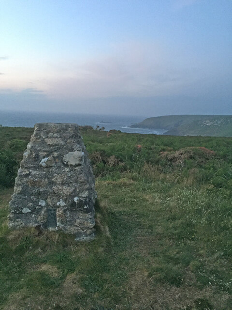
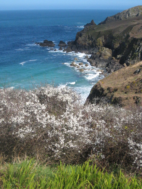
Boswednack is known for its breathtaking natural surroundings, with rolling hills, picturesque moorlands, and dramatic cliffs overlooking the Atlantic Ocean. The area is a haven for hikers, nature enthusiasts, and those seeking a tranquil escape from the hustle and bustle of city life.

Despite its small size, Boswednack boasts a rich history. The hamlet is home to several ancient sites, including the Boswednack Manor, a medieval manor house dating back to the 14th century. The manor is a Grade II listed building and provides a glimpse into the area's historical past.

Surrounded by the wild beauty of the Cornish countryside, Boswednack offers a peaceful retreat for visitors. The hamlet is an ideal base for exploring the stunning coastal paths, discovering hidden coves, and immersing oneself in the unique charm of Cornwall. Additionally, the nearby village of Zennor offers amenities such as traditional pubs and local shops, ensuring that visitors have all the essentials within reach.

In summary, Boswednack is a small yet captivating hamlet in Cornwall, renowned for its natural beauty, historical significance, and its ability to provide a sense of tranquility and escape for those who venture to this picturesque corner of England.

If you have any feedback on the listing, please let us know in the comments section below.
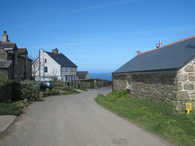
Boswednack Images

Images are sourced within 2km of 50.184403/-5.582663 or Grid Reference SW4437. Thanks to Geograph Open Source API. All images are credited.

Coastal views near Zennor in the fading light
Footpath to Zennor Head
Zennor Cliff Trig Point Flush Bracket S8143
The buildings at Bosporthennis These are no longer completely abandoned (see: <a title="https://www.geograph.org.uk/photo/71726)," href="https://www.geograph.org.uk/photo/71726),">Link</a> but have been restored as a holiday home. So just abandoned for the majority of the year.
The buildings at Bosporthennis
These are no longer completely abandoned (see: Link but have been restored as a holiday home. So just abandoned for the majority of the year.
Porthmeor Cove from the South West Coast Path
Stone Stile SW4236b On farm land north of B3306 and west of Bosigran farm buildings, next to farm gate on track between late prehistoric and medieval field boundaries at Bosigran. On public footpath 120/15/2 Gold. Cattle stile with granite block balanced on two blocks and one granite step each side; next to gate. Looking west.
Stone Stile SW4236b
On farm land north of B3306 and west of Bosigran farm buildings, next to farm gate on track between late prehistoric and medieval field boundaries at Bosigran. On public footpath 120/15/2 Gold. Cattle stile with granite block balanced on two blocks and one granite step each side; next to gate. Looking west.
Stone Stile SW4236b On farm land north of B3306 and west of Bosigran farm buildings, next to farm gate on track between late prehistoric and medieval field boundaries at Bosigran. On public footpath 120/15/2 Gold. Cattle stile with granite block balanced on two blocks and one granite step each side; next to gate. Looking east to Bosigran farmstead
Stone Stile SW4236b
On farm land north of B3306 and west of Bosigran farm buildings, next to farm gate on track between late prehistoric and medieval field boundaries at Bosigran. On public footpath 120/15/2 Gold. Cattle stile with granite block balanced on two blocks and one granite step each side; next to gate. Looking east to Bosigran farmstead
Stone Stile SW4237a Boundary from field into Bosigran farm buildings, on Bosigran farm land north of B3306, west of Porthmeor stream. Public footpath 120/15/1 and 120/14/3 Gold. Circa early C19. Dressed granite moorstone and granite rubble. Stepped cattle stile adjoining rubble-faced hedge. Parish: Zennor
HER Number: DCO11754  Grade II listed No. 1144347
Stone Stile SW4237a
Boundary from field into Bosigran farm buildings, on Bosigran farm land north of B3306, west of Porthmeor stream. Public footpath 120/15/1 and 120/14/3 Gold. Circa early C19. Dressed granite moorstone and granite rubble. Stepped cattle stile adjoining rubble-faced hedge. Parish: Zennor HER Number: DCO11754 Grade II listed No. 1144347
Stone Stile SW4237a Boundary from field into Bosigran farm buildings, on Bosigran farm land north of B3306, west of Porthmeor stream. Public footpath 120/15/1 and 120/14/3 Gold. Dressed granite moorstone and granite rubble. Stepped cattle stile adjoining rubble-faced hedge.
Parish: Zennor
HER Number: DCO11754  Grade II listed No. 1144347
Stone Stile SW4237a
Boundary from field into Bosigran farm buildings, on Bosigran farm land north of B3306, west of Porthmeor stream. Public footpath 120/15/1 and 120/14/3 Gold. Dressed granite moorstone and granite rubble. Stepped cattle stile adjoining rubble-faced hedge. Parish: Zennor HER Number: DCO11754 Grade II listed No. 1144347
Stone Stile SW4237b Three stone steps. At eastern end of enclosed track at Bosigran/Lower Porthmeor tin working site. The stile leads south from the enclosed lane, at right angles to a second stile which is on the main path running east. Path number 120/14 gold.
Parish: Zennor
HER Number: DCO11914  Grade II listed 1137458 ‘Aqueduct and Stiles’
Stone Stile SW4237b
Three stone steps. At eastern end of enclosed track at Bosigran/Lower Porthmeor tin working site. The stile leads south from the enclosed lane, at right angles to a second stile which is on the main path running east. Path number 120/14 gold. Parish: Zennor HER Number: DCO11914 Grade II listed 1137458 ‘Aqueduct and Stiles’
Stone Stile SW4237c Cattle stile with three large steps. Public footpath 120/14/3 gold & 120/14/2 silver from: Bosigran to: Lower Porthmeor. 
Parish: Zennor
HER Number: DCO11914  Grade II listed 1137458 ‘Aqueduct and Stiles’
Stone Stile SW4237c
Cattle stile with three large steps. Public footpath 120/14/3 gold & 120/14/2 silver from: Bosigran to: Lower Porthmeor. Parish: Zennor HER Number: DCO11914 Grade II listed 1137458 ‘Aqueduct and Stiles’
Stone Stile SW4237c Cattle stile with three large steps. Public footpath 120/14/3 gold & 120/14/2 silver from Bosigran to Lower Porthmeor. 
Parish: Zennor
HER Number: DCO11914  Grade II listed 1137458 ‘Aqueduct and Stiles’
Stone Stile SW4237c
Cattle stile with three large steps. Public footpath 120/14/3 gold & 120/14/2 silver from Bosigran to Lower Porthmeor. Parish: Zennor HER Number: DCO11914 Grade II listed 1137458 ‘Aqueduct and Stiles’
Stone Stile SW4237d Cattle stile with three large steps each side. At western end of enclosed track at Bosigran/Lower Porthmeor tin working site. Public footpath 120/14/3 gold 
Parish: Zennor
HER Number: DCO11914  Grade II listed 1137458 ‘Aqueduct and Stiles’
Stone Stile SW4237d
Cattle stile with three large steps each side. At western end of enclosed track at Bosigran/Lower Porthmeor tin working site. Public footpath 120/14/3 gold Parish: Zennor HER Number: DCO11914 Grade II listed 1137458 ‘Aqueduct and Stiles’
Footpath looking west near Captain's House in Portmeor
Stone Stile Sw4337a Zennor A cattle stile with two steps each side situated at the commencement of a footpath heading off the B3306. There is a small stream here. Public footpath 120/9/1 B3306 to Treen.
Stone Stile Sw4337a Zennor
A cattle stile with two steps each side situated at the commencement of a footpath heading off the B3306. There is a small stream here. Public footpath 120/9/1 B3306 to Treen.
Stone Stile SW4337a Zennor Cattle stile with two steps each side, situated at the commencement of a footpath heading off the B3306. There is a small stream here. Looking west, the yellow-painted Gurnard's Head inn can be seen, approximately a quarter of a mile away at Treen. Public footpath 120/9/1 B3306 to Treen
Stone Stile SW4337a Zennor
Cattle stile with two steps each side, situated at the commencement of a footpath heading off the B3306. There is a small stream here. Looking west, the yellow-painted Gurnard's Head inn can be seen, approximately a quarter of a mile away at Treen. Public footpath 120/9/1 B3306 to Treen
Stone Stile SW4438a One of several stiles on a footpath across fields in a westerly direction to Poniou. 
A simple coffen-type stile of granite slabs.
Public footpath 120/6/1 gold Trewey to Poniou.
Stone Stile SW4438a
One of several stiles on a footpath across fields in a westerly direction to Poniou. A simple coffen-type stile of granite slabs. Public footpath 120/6/1 gold Trewey to Poniou.
Show me another place!

Boswednack is located at Grid Ref: SW4437 (Lat: 50.184403, Lng: -5.582663)

Unitary Authority: Cornwall

Police Authority: Devon and Cornwall

What 3 Words

///positive.procures.commands. Near St Ives, Cornwall

Nearby Locations

Boswednack

Related Wikis

Boswednack

Boswednack is a hamlet in the parish of Zennor near the north coast of the Penwith peninsula in Cornwall, England, United Kingdom. It is located along...

Poniou

Poniou or Ponjou is a hamlet west of Zennor in west Cornwall, England. The name is from Cornish "ponjow" meaning "bridges". == References ==

Treen, Zennor

Treen (Cornish: Tredhin) is a hamlet in the parish of Zennor, on the north coast of the Penwith peninsula in Cornwall, England, United Kingdom. It lies...

Treen Cove

Treen Cove (grid reference SW435383) is a tidal beach on the north coast of the Penwith peninsula, Cornwall, England, UK. It is about half a mile northwest...

Nearby Amenities

Located within 500m of 50.184403,-5.582663
Boswednack
Name Kw: Boswydnek
Place: hamlet
Wikidata: Q4948328
Wikipedia: en:Boswednack
Lat/Long: 50.1848714/-5.5837868
Heritage: yes
Historic: archaeological_site
Wikidata: Q17644327
Lat/Long: 50.1827054/-5.5767216
Poniou
Name Kw: Ponjow
Place: hamlet
Wikidata: Q7227853
Wikipedia: en:Poniou
Lat/Long: 50.1868788/-5.5812367
Power: pole
Lat/Long: 50.1837969/-5.5763702
Power: pole
Transformer: distribution
Lat/Long: 50.1841731/-5.5776536
Power: pole
Lat/Long: 50.1846642/-5.5784798
Power: pole
Lat/Long: 50.1859515/-5.5792911
Power: pole
Lat/Long: 50.186647/-5.5793676
Power: pole
Transformer: distribution
Lat/Long: 50.187267/-5.5793971
Power: pole
Lat/Long: 50.1881188/-5.5794722
Power: pole
Lat/Long: 50.1851211/-5.579267
Power: pole
Lat/Long: 50.184921/-5.5807717
Power: pole
Lat/Long: 50.1847287/-5.5821316
Power: pole
Transformer: distribution
Lat/Long: 50.1845715/-5.5832179
Power: pole
Lat/Long: 50.1842194/-5.5836698
Power: pole
Lat/Long: 50.1835273/-5.5844866
Power: pole
Lat/Long: 50.1827372/-5.5854186
Power: pole
Lat/Long: 50.1820382/-5.5862837
Power: pole
Lat/Long: 50.1814018/-5.5870441
Power: pole
Lat/Long: 50.1871004/-5.578123
The data included in this document is from www.openstreetmap.org. The data is made available under ODbL.

Have you been to Boswednack?

Leave your review of Boswednack below (or comments, questions and feedback).