Bossington

Settlement in Hampshire Test Valley

England

Bossington

Houghton Ford This ford is found on the River Test at Houghton. The couple in the foreground are wild water swimmers. Fortunately temperatures were unseasonably high for January at around 11 degrees.
Houghton Ford Credit: John Walton

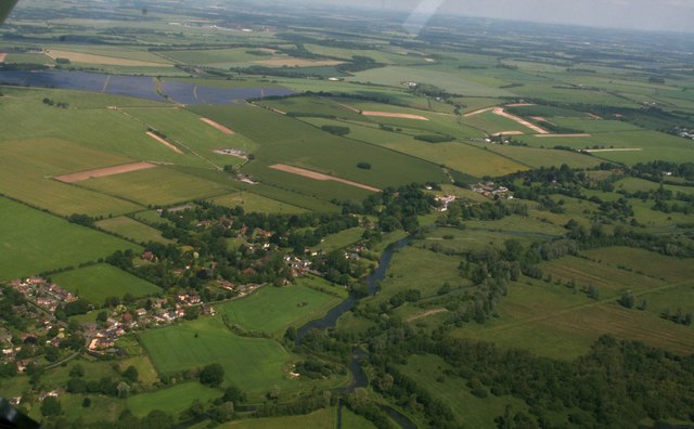
Bossington is a small village located in the New Forest district of Hampshire, England. Situated within the boundaries of the New Forest National Park, Bossington is renowned for its picturesque countryside, charming cottages, and tranquil atmosphere. The village is nestled between the towns of Lymington and Beaulieu, offering residents and visitors easy access to a range of amenities and attractions.

One of the defining features of Bossington is its close proximity to the coast. The village is just a short distance from the stunning beaches of the Solent, providing an abundance of opportunities for coastal walks, water sports, and relaxation by the sea. The nearby salt marshes and mudflats also attract a diverse range of bird species, making Bossington an ideal spot for birdwatchers and nature enthusiasts.

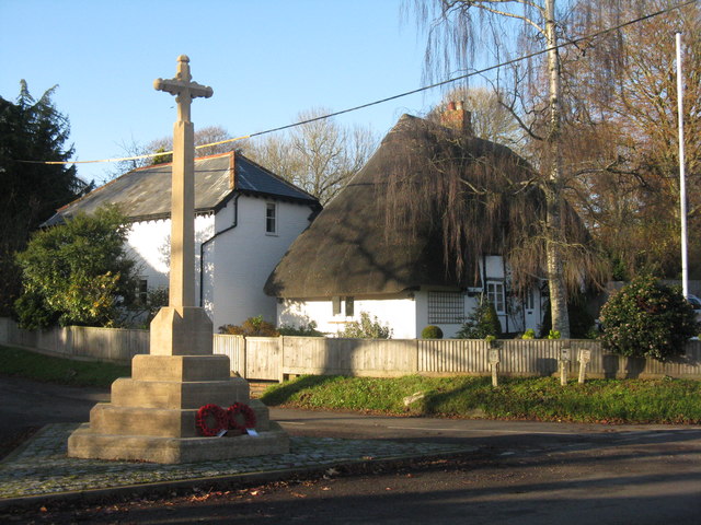
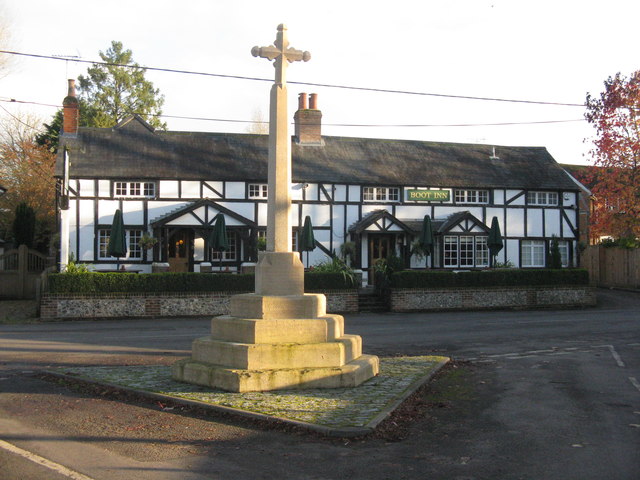
The architecture in Bossington is predominantly traditional, with many of the cottages and buildings dating back to the 18th and 19th centuries. The village is known for its well-preserved thatched roofs, timber-framed structures, and cob walls, giving it a quintessential English countryside charm.

In addition to its natural beauty, Bossington boasts a strong sense of community. The village has a close-knit population, and residents often come together for events and activities such as village fairs, fundraisers, and social gatherings.

Overall, Bossington offers a peaceful retreat for those seeking a rural and idyllic setting, with its stunning natural landscapes, historic architecture, and strong community spirit.

If you have any feedback on the listing, please let us know in the comments section below.

Bossington Images

Images are sourced within 2km of 51.081315/-1.517438 or Grid Reference SU3331. Thanks to Geograph Open Source API. All images are credited.

Houghton Ford This ford is found on the River Test at Houghton. The couple in the foreground are wild water swimmers. Fortunately temperatures were unseasonably high for January at around 11 degrees.
Houghton Ford
This ford is found on the River Test at Houghton. The couple in the foreground are wild water swimmers. Fortunately temperatures were unseasonably high for January at around 11 degrees.
Cow Drove Hill On the shoulder of the Test valley. The hill the lane is named after is some way back.
Cow Drove Hill
On the shoulder of the Test valley. The hill the lane is named after is some way back.
Cow Drove Hill Looking down into the Test valley.
Cow Drove Hill
Looking down into the Test valley.
Horsebridge railway station (site), Hampshire Opened in 1865 by the London & South Western Railway on the "Sprat & Winkle" line from Andover to Romsey, this station closed in 1964. It became derelict but has since been restored as a private residence and wedding venue.
View south west towards Mottisfont and Romsey.
Horsebridge railway station (site), Hampshire
Opened in 1865 by the London & South Western Railway on the "Sprat & Winkle" line from Andover to Romsey, this station closed in 1964. It became derelict but has since been restored as a private residence and wedding venue. View south west towards Mottisfont and Romsey.
Houghton and River Test: aerial 2017
Water meadows in the Test Valley With willows catching the low autumn sun.
Water meadows in the Test Valley
With willows catching the low autumn sun.
Meadow in the Test Valley Wet pasture and woodland.
Meadow in the Test Valley
Wet pasture and woodland.
Thatched house at Houghton And the War Memorial.
Thatched house at Houghton
And the War Memorial.
War Memorial at Houghton And the Boot Inn - an excellent place for lunch.
War Memorial at Houghton
And the Boot Inn - an excellent place for lunch.
Thatched house at Houghton
The Boot Inn pub sign With riding boots, which are quite frequently seen in the area.
The Boot Inn pub sign
With riding boots, which are quite frequently seen in the area.
Field edge at King's Somborne
Park Stream, looking downstream
Park Stream, looking upstream
Former Horsebridge mill and mill house
John O'Gaunt Inn, Horsebridge
Former railway bridge on the Test Way
Rough field beside the Test Way
Show me another place!

Bossington is located at Grid Ref: SU3331 (Lat: 51.081315, Lng: -1.517438)

Administrative County: Hampshire

District: Test Valley

Police Authority: Hampshire

What 3 Words

///lamp.tidying.registers. Near East Dean, Hampshire

Nearby Locations

Bossington

Related Wikis

Houghton, Hampshire

Houghton ( HOH-tən) is a small village and civil parish in the Test Valley district of Hampshire, England. The village is situated alongside the River...

Bossington, Hampshire

Bossington is a village and civil parish in the Test Valley district of Hampshire, England. According to the 2001 census it had a population of 41. The...

Testway

Testway is a 5-mile (8 km) off-road cycle path in Hampshire, England. The path follows the route of the disused Sprat and Winkle Line between Stonymarsh...

Horsebridge railway station

Horsebridge was a railway station on the closed Sprat and Winkle Line which served the Hampshire village of Houghton. It closed in 1964, a casualty of...

Nearby Amenities

Located within 500m of 51.081315,-1.517438
Odbl: clean
Lat/Long: 51.084102/-1.5119616
Odbl: clean
Lat/Long: 51.0817312/-1.5137324
Odbl: clean
Lat/Long: 51.0798076/-1.5172444
Odbl: clean
Lat/Long: 51.0782853/-1.518423
Bus Stop
Houghton Corner
Bus: yes
Naptan AtcoCode: 1900HA100183
Naptan Bearing: SW
Naptan CommonName: Houghton Corner
Naptan Crossing: Faithfulls Drove
Naptan NaptanCode: hamamgdm
Naptan Street: Unamed Road From Stockbridge
Naptan Verified: no
Public Transport: platform
Source: naptan_import
Lat/Long: 51.0830858/-1.5166475
Bus Stop
Houghton Corner
Bus: yes
Naptan AtcoCode: 1900HA100184
Naptan Bearing: NE
Naptan CommonName: Houghton Corner
Naptan Crossing: Faithfulls Drove
Naptan NaptanCode: hamamgdj
Naptan Street: Unamed Road From Stockbridge
Naptan Verified: no
Public Transport: platform
Source: naptan_import
Lat/Long: 51.0831222/-1.5167328
Bus Stop
Houghton Corner
Bus: yes
Naptan AtcoCode: 1900WIA13715
Naptan Bearing: SE
Naptan CommonName: Houghton Corner
Naptan NaptanCode: hamamgdg
Naptan Street: Horsebridge Road
Naptan Verified: no
Public Transport: platform
Source: naptan_import
Lat/Long: 51.0821153/-1.5168004
Bus Stop
Houghton Corner
Bus: yes
Naptan AtcoCode: 1900WIA13716
Naptan Bearing: NW
Naptan CommonName: Houghton Corner
Naptan NaptanCode: hamamgat
Naptan Street: Horsebridge Road
Naptan Verified: no
Public Transport: platform
Source: naptan_import
Lat/Long: 51.0821705/-1.5170996
Power: pole
Source: Bing
Lat/Long: 51.082775/-1.521472
Power: pole
Source: Bing
Lat/Long: 51.0820604/-1.5226307
Power: pole
Source: Bing
Lat/Long: 51.0854034/-1.5191712
Power: pole
Source: Bing
Lat/Long: 51.0834808/-1.5203322
Material: wood
Power: pole
Source: Bing
Lat/Long: 51.0840992/-1.5193213
Power: pole
Source: Bing
Lat/Long: 51.081287/-1.5238942
Power: pole
Source: Bing
Lat/Long: 51.0842979/-1.5222366
Power: pole
Source: Bing
Lat/Long: 51.0842794/-1.520748
Material: wood
Power: pole
Source: Bing
Lat/Long: 51.0842759/-1.5193884
Post Box
Collection Plate: CP7D
Collection Times: Mo-Fr 09:00; Sa 07:00
Operator: Royal Mail
Post Box Type: lamp
Ref: SO20 45D
Royal Cypher: EIIR
Royal Cypher Wikidata: Q33102113
Lat/Long: 51.0830279/-1.5166449
Turning Loop
Lat/Long: 51.0815683/-1.5161686
Material: wood
Power: pole
Lat/Long: 51.0843349/-1.5192917
Power: pole
Lat/Long: 51.0838471/-1.516474
Power: pole
Lat/Long: 51.0840662/-1.5167825
Material: wood
Power: pole
Lat/Long: 51.0841951/-1.5179949
Power: pole
Lat/Long: 51.0836104/-1.5182416
Power: pole
Lat/Long: 51.0829432/-1.5184937
Power: pole
Transformer: distribution
Lat/Long: 51.0822658/-1.5187687
Power: pole
Lat/Long: 51.0820333/-1.5199998
Power: pole
Lat/Long: 51.0817831/-1.521239
Power: pole
Lat/Long: 51.0815354/-1.5224607
Power: pole
Lat/Long: 51.0812826/-1.5236717
Power: pole
Lat/Long: 51.0804587/-1.524168
Fountain
Lat/Long: 51.0782819/-1.519608
Power: pole
Lat/Long: 51.0825085/-1.5110359
Power: pole
Lat/Long: 51.0820358/-1.5130328
Location Transition: yes
Power: pole
Lat/Long: 51.0831403/-1.5154789
Location Transition: yes
Power: pole
Lat/Long: 51.083086/-1.5155701
Power: pole
Lat/Long: 51.0826222/-1.5145227
Power: pole
Lat/Long: 51.0819802/-1.5130784
Power: pole
Lat/Long: 51.082447/-1.5110265
Bossington
Place: hamlet
Lat/Long: 51.0800308/-1.5177246
Houghton Drayton
Place: hamlet
Lat/Long: 51.0840749/-1.5188116
The data included in this document is from www.openstreetmap.org. The data is made available under ODbL.

Have you been to Bossington?

Leave your review of Bossington below (or comments, questions and feedback).