The Knap

Settlement in Glamorgan

Wales

The Knap

Promenade Colonnade above Whitmore Bay
Promenade Colonnade above Whitmore Bay Credit: Alan Hughes

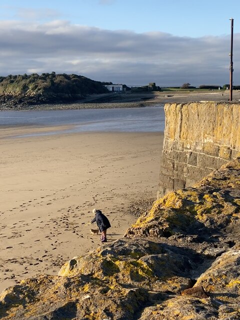
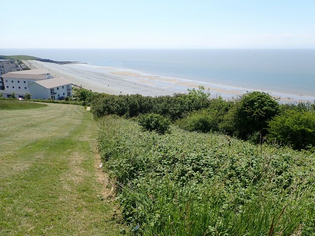
The Knap is a coastal area located in Glamorgan, Wales. It is situated south of Barry and is renowned for its picturesque beauty and rich history. The Knap is nestled between the Bristol Channel and the Vale of Glamorgan, providing stunning views of the sea and surrounding countryside.

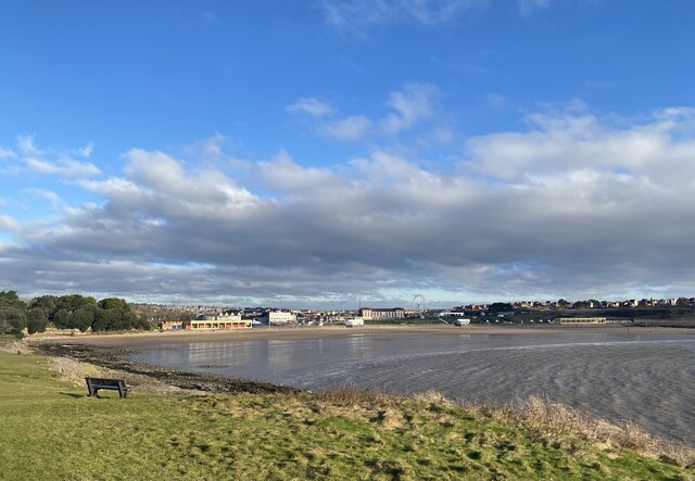
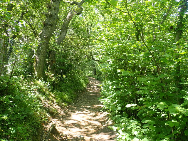
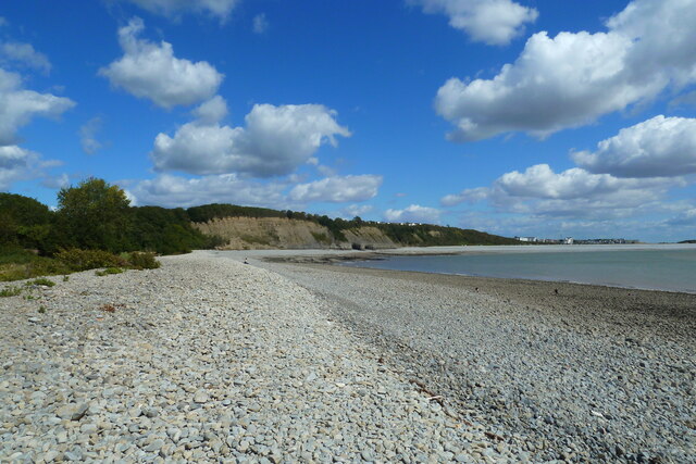
The area is known for its sandy beach, which stretches for approximately two miles. The beach is a popular destination for locals and tourists alike, offering opportunities for sunbathing, swimming, and various water sports. The Knap also boasts a beautiful promenade that runs along the beach, perfect for leisurely walks and enjoying the scenic views.

One of the key attractions at The Knap is the Knap Gardens. These well-maintained gardens feature an array of colorful flowers, shrubs, and trees, creating a tranquil and relaxing atmosphere. The gardens also house a large lake, which is home to a variety of waterfowl and provides a peaceful spot for picnics or feeding the ducks.

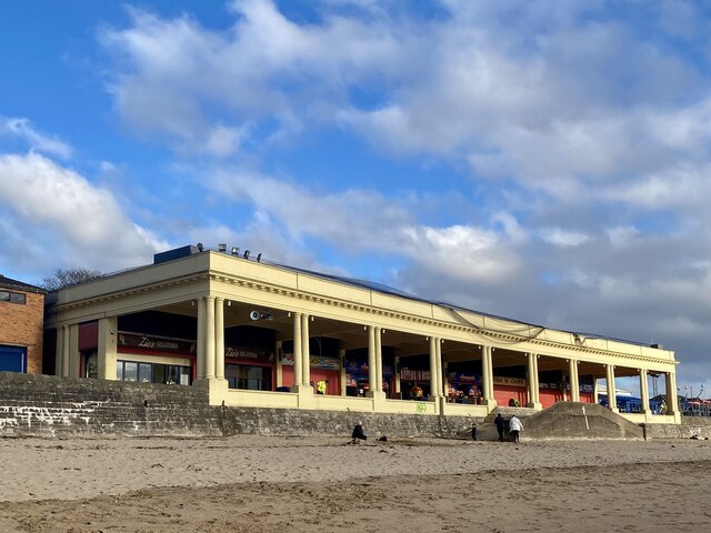
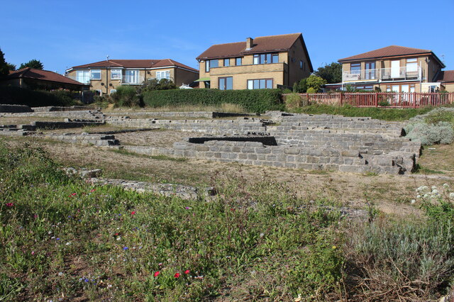
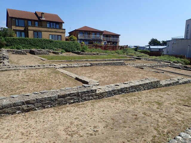
In addition to its natural beauty, The Knap has a rich history. The area was originally developed as a Victorian seaside resort in the late 19th century, and remnants of this era can still be seen in the architectural style of some buildings. The Knap also has historical significance as it was used as a military training ground during World War II.

Overall, The Knap in Glamorgan offers a perfect blend of natural beauty, recreational activities, and historical charm, making it a must-visit destination for nature enthusiasts, history buffs, and those seeking a peaceful coastal retreat.

If you have any feedback on the listing, please let us know in the comments section below.

The Knap Images

Images are sourced within 2km of 51.390836/-3.2924209 or Grid Reference ST1066. Thanks to Geograph Open Source API. All images are credited.

Promenade Colonnade above Whitmore Bay
Whitmore Bay, Barry Island
Fetch! Owner and dog alongside the old harbour wall.
Fetch!
Owner and dog alongside the old harbour wall.
Pigeons ready for the race … or just having a natter?
Pigeons ready for the race
… or just having a natter?
Fallen rocks Unstable cliff face at Barry Island.
Fallen rocks
Unstable cliff face at Barry Island.
Remains of Roman building, The Knapp Bases of the limestone walls of a late Roman building around a central courtyard; of uncertain function. Situated next to the Wales Coast Path amongst modern dwellings. For a better view of the far end of the site - <a href="https://www.geograph.org.uk/photo/272229">ST0966 : Roman Villa</a>.
Remains of Roman building, The Knapp
Bases of the limestone walls of a late Roman building around a central courtyard; of uncertain function. Situated next to the Wales Coast Path amongst modern dwellings. For a better view of the far end of the site - ST0966 : Roman Villa.
Church of St Curig and Church Cross, Porthkerry The church has its origins in the second half of the C13 and much of the walling is still medieval, although restored. The tower was added in the late C15 or early C16, as was the porch, although this was much rebuilt in 1867. There was a major restoration in that year when the east wall of the nave and the chancel arch were rebuilt, the vestry was added and the church re-roofed. The top of the tower was rebuilt in 1958.
The Church and the Church Cross are both listed at Grade II by Cadw.
Church of St Curig and Church Cross, Porthkerry
The church has its origins in the second half of the C13 and much of the walling is still medieval, although restored. The tower was added in the late C15 or early C16, as was the porch, although this was much rebuilt in 1867. There was a major restoration in that year when the east wall of the nave and the chancel arch were rebuilt, the vestry was added and the church re-roofed. The top of the tower was rebuilt in 1958. The Church and the Church Cross are both listed at Grade II by Cadw.
Roman remains, the Knap On the bank near the Knap car park are the remains of a large Roman building, believed to have been constructed c 290 A.D. Limestone and brick was taken from the site in the Middle Ages and used to build Barry Castle.
Roman remains, the Knap
On the bank near the Knap car park are the remains of a large Roman building, believed to have been constructed c 290 A.D. Limestone and brick was taken from the site in the Middle Ages and used to build Barry Castle.
Wales Coast Path near the Knap, Barry A steep hill to the top of Bull Cliff
Wales Coast Path near the Knap, Barry
A steep hill to the top of Bull Cliff
Houses on Marine Drive Above Bull Cliff
Houses on Marine Drive
Above Bull Cliff
Wales Coast Path in Cliff Wood On the way to Porothkerry
Wales Coast Path in Cliff Wood
On the way to Porothkerry
Porthkerry Viaduct Porthkerry viaduct was built during the construction of the Vale of Glamorgan Railway in the 1890s. Remaining one of the notable industrial monuments of the area, it was constructed of stone with thirteen 50 feet and three 45 feet arches, reaching a maximum height of 110 feet. Work on the viaduct was troubled by subsidence in 1896 causing the temporary closure and the construction of a loop line. The viaduct finally opened to traffic in 1900.
Porthkerry Viaduct
Porthkerry viaduct was built during the construction of the Vale of Glamorgan Railway in the 1890s. Remaining one of the notable industrial monuments of the area, it was constructed of stone with thirteen 50 feet and three 45 feet arches, reaching a maximum height of 110 feet. Work on the viaduct was troubled by subsidence in 1896 causing the temporary closure and the construction of a loop line. The viaduct finally opened to traffic in 1900.
Wales Coast Path between the Knap and Porthkerry
Pebble beach at Porthkerry Country Park
Porthkerry Beach and Bull Cliff Porthkerry beach and Bull Cliff looking north east towards Cold Knapp.
Porthkerry Beach and Bull Cliff
Porthkerry beach and Bull Cliff looking north east towards Cold Knapp.
Walking with two poles The bridge is still in use, carrying the Vale of Glamorgan line from Barry to Bridgend.
Walking with two poles
The bridge is still in use, carrying the Vale of Glamorgan line from Barry to Bridgend.
Public footpath Path through Porthkerry Park.
Public footpath
Path through Porthkerry Park.
Towards a solitary tree I wonder why the tractor veered to the left.
Towards a solitary tree
I wonder why the tractor veered to the left.
Show me another place!

The Knap is located at Grid Ref: ST1066 (Lat: 51.390836, Lng: -3.2924209)

Unitary Authority: The Vale of Glamorgan

Police Authority: South Wales

What 3 Words

///signature.circulate.purchaser. Near Barry, Vale of Glamorgan

Related Wikis

Cold Knap

Cold Knap is a district of Barry in South Wales. == Amenities == Cold Knap is a coastal pebble beach (with some sand at low tide), approximately a mile...

Barry railway station

Barry railway station (Welsh: Y Barri) is one of three stations serving the town of Barry, Vale of Glamorgan in South Wales. This one, Barry Town, is preceded...

Romilly, Vale of Glamorgan

Romilly is a western district of Barry in the Vale of Glamorgan, South Wales, United Kingdom. The area has an attractive public park which includes an...

Woodham Brothers

Woodham Brothers Ltd is a trading business, based mainly around activities and premises located within Barry Docks, in Barry, South Wales. It is noted...

Nearby Amenities

Located within 500m of 51.390836,-3.2924209
Source: PGS
Lat/Long: 51.3909731/-3.2994525
Source: PGS
Lat/Long: 51.390866/-3.2991414
Source: PGS
Lat/Long: 51.3906585/-3.2985835
Source: PGS
Lat/Long: 51.3903907/-3.2978539
Source: PGS
Lat/Long: 51.3901697/-3.2974247
Source: PGS
Lat/Long: 51.3896676/-3.2963304
Source: PGS
Lat/Long: 51.3890249/-3.2951288
Source: PGS
Lat/Long: 51.3881344/-3.2935302
Source: PGS
Lat/Long: 51.3875453/-3.2924573
Source: PGS
Lat/Long: 51.387023/-3.2915668
Source: PGS
Lat/Long: 51.3868389/-3.2891716
Source: PGS
Lat/Long: 51.3873879/-3.2889757
Source: PGS
Lat/Long: 51.3876239/-3.2896356
Source: PGS
Lat/Long: 51.3897514/-3.2856659
Source: PGS
Lat/Long: 51.3896957/-3.2858125
Source: PGS
Lat/Long: 51.3896626/-3.2858369
Source: PGS
Lat/Long: 51.3896879/-3.2856796
Source: PGS
Lat/Long: 51.3897389/-3.2855456
Parking
Parking: surface
Lat/Long: 51.3921753/-3.2929479
Barrier: bollard
Lat/Long: 51.3895413/-3.2907034
The Knap
Place: suburb
Wikidata: Q5142291
Lat/Long: 51.3905035/-3.2915015
Watch House Bay
Name Cy: Bae'r Tŵr Gwylio
Natural: bay
Source: OS_OpenData_StreetView
Lat/Long: 51.3882163/-3.2891681
Seamark Light Category: vertical
Seamark Light Character: F
Seamark Light Colour: green
Seamark Light Height: 5
Seamark Light Multiple: 2
Seamark Light Range: 5
Seamark Light Reference: A 5411
Seamark Type: light_minor
Source: US NGA Pub. 114. 2011-05-26.
Lat/Long: 51.3896621/-3.2858024
Railway: switch
Lat/Long: 51.3935063/-3.2952678
Lifeguard
Description: Lifeguard Station
Emergency: lifeguard
Opening Hours: Varied
Lat/Long: 51.3874377/-3.2904382
Crossing
Crossing: unmarked
Lat/Long: 51.389972/-3.2955409
Cold Knap Point
Natural: cape
Lat/Long: 51.3868811/-3.2901967
Post Box
Collection Times: Mo-Fr 09:00; Sa 07:00; Su off
Operator: Royal Mail
Post Box Type: pillar
Ref: CF62 29D
Lat/Long: 51.3919247/-3.2921769
Direction: 215
Generator Method: photovoltaic
Generator Output Electricity: yes
Generator Solar Modules: 16
Generator Source: solar
Generator Type: solar_photovoltaic_panel
Location: roof
Power: generator
Lat/Long: 51.3932768/-3.2880416
Direction: 35
Generator Method: photovoltaic
Generator Output Electricity: yes
Generator Solar Modules: 4
Generator Source: solar
Generator Type: solar_photovoltaic_panel
Location: roof
Power: generator
Lat/Long: 51.3929279/-3.2883199
Direction: 125
Generator Method: photovoltaic
Generator Output Electricity: yes
Generator Solar Modules: 3
Generator Source: solar
Generator Type: solar_photovoltaic_panel
Location: roof
Power: generator
Lat/Long: 51.3928994/-3.2883286
Direction: 215
Generator Method: photovoltaic
Generator Output Electricity: yes
Generator Solar Modules: 4
Generator Source: solar
Generator Type: solar_photovoltaic_panel
Location: roof
Power: generator
Lat/Long: 51.3928908/-3.2883802
Direction: 165
Generator Method: photovoltaic
Generator Output Electricity: yes
Generator Solar Modules: 7
Generator Source: solar
Generator Type: solar_photovoltaic_panel
Location: roof
Power: generator
Lat/Long: 51.3905676/-3.2950602
Direction: 215
Generator Method: photovoltaic
Generator Output Electricity: yes
Generator Solar Modules: 6
Generator Source: solar
Generator Type: solar_photovoltaic_panel
Location: roof
Power: generator
Lat/Long: 51.3906333/-3.2964731
Direction: 275
Generator Method: photovoltaic
Generator Output Electricity: yes
Generator Solar Modules: 16
Generator Source: solar
Generator Type: solar_photovoltaic_panel
Location: roof
Power: generator
Lat/Long: 51.3924919/-3.2956664
Direction: 215
Generator Method: photovoltaic
Generator Output Electricity: yes
Generator Solar Modules: 14
Generator Source: solar
Generator Type: solar_photovoltaic_panel
Location: roof
Power: generator
Lat/Long: 51.39174/-3.2899822
Direction: 175
Generator Method: photovoltaic
Generator Output Electricity: yes
Generator Solar Modules: 6
Generator Source: solar
Generator Type: solar_photovoltaic_panel
Location: roof
Power: generator
Lat/Long: 51.3902454/-3.2919107
Direction: 170
Generator Method: photovoltaic
Generator Output Electricity: yes
Generator Solar Modules: 11
Generator Source: solar
Generator Type: solar_photovoltaic_panel
Location: roof
Power: generator
Lat/Long: 51.3910557/-3.2918875
Drinking Water
Access: yes
Bottle: yes
Covered: no
Fee: no
Operator: Vale of Glamorgan County Borough Council
Wheelchair: yes
Lat/Long: 51.3953098/-3.2916689
Drinking Water
Access: yes
Bottle: yes
Covered: no
Fee: no
Note: rough location
Operator: Vale of Glamorgan County Borough Council
Wheelchair: yes
Lat/Long: 51.3877286/-3.2906342
Bench
Backrest: yes
Lat/Long: 51.3944157/-3.2919613
Bench
Backrest: yes
Lat/Long: 51.394415/-3.2918407
Bench
Backrest: yes
Lat/Long: 51.3944662/-3.2917337
Bench
Backrest: yes
Lat/Long: 51.3946209/-3.2916208
Bench
Backrest: yes
Lat/Long: 51.3946733/-3.2915849
Bench
Backrest: yes
Lat/Long: 51.3947781/-3.2915288
Charging Station
Access: yes
Charging Station Output: 22 kW
Fee: yes
Operator: Connected Kerb
Operator Wikidata: Q113579669
Lat/Long: 51.3901796/-3.2962809
Charging Station
Access: yes
Charging Station Output: 22 kW
Fee: yes
Operator: Connected Kerb
Operator Wikidata: Q113579669
Lat/Long: 51.3902095/-3.29634
Charging Station
Access: yes
Charging Station Output: 22 kW
Fee: yes
Operator: Connected Kerb
Operator Wikidata: Q113579669
Lat/Long: 51.392236/-3.2922102
Charging Station
Access: yes
Charging Station Output: 22 kW
Fee: yes
Operator: Connected Kerb
Operator Wikidata: Q113579669
Lat/Long: 51.3922432/-3.2922894
The data included in this document is from www.openstreetmap.org. The data is made available under ODbL.

Have you been to The Knap?

Leave your review of The Knap below (or comments, questions and feedback).