Taverham

Settlement in Norfolk Broadland

England

Taverham

Old Milestone, Drayton On the South side of the A1067, 20yds W of junction with Taverham Road, in the parish of Drayton. Alternative views are <a href="https://www.geograph.org.uk/photo/1391707">TG1713 : Drayton Milestone</a> & <a href="https://www.geograph.org.uk/photo/1558894">TG1713 : Old Milepost</a>.

Inscription: To / Norwich / 4 / Miles // Fakenham / 20 // Drayton

Milestone Society National ID: NO_NF04
Old Milestone, Drayton Credit: Alan Lake

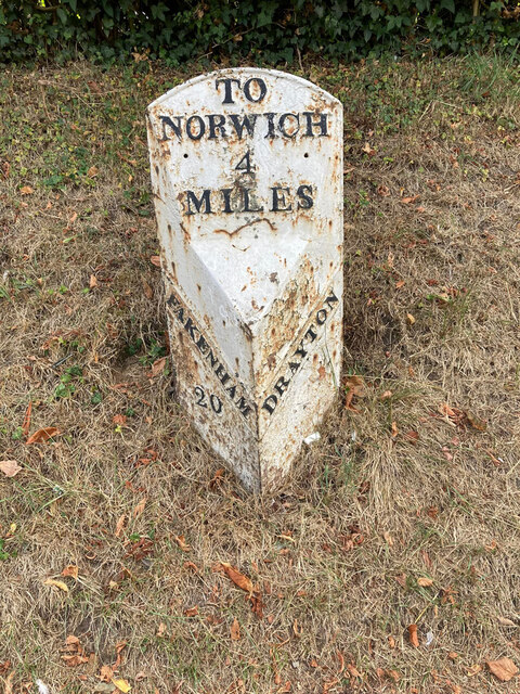
Taverham is a village and civil parish located in the county of Norfolk, England. Situated approximately 6 miles northwest of Norwich city center, Taverham is a vibrant and picturesque residential area that offers a peaceful countryside setting with convenient access to urban amenities.

The village is known for its rich history, which dates back to the Roman era. The name "Taverham" is derived from the Old English words "tāfern" and "hām," meaning "farmstead where beer is sold." This suggests a long tradition of hospitality and commerce in the area. Today, Taverham retains its historical charm, with many traditional buildings and landmarks dotting the landscape.

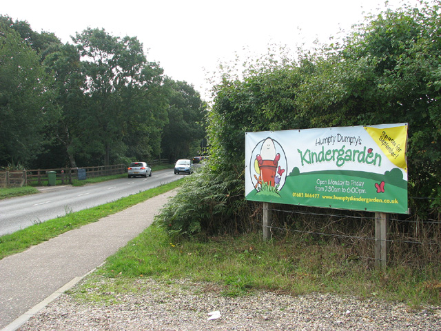
Taverham is well-served by amenities and facilities that cater to the needs of its residents. The village features a variety of shops, including a supermarket, local stores, and a garden center, providing convenient access to everyday essentials. Additionally, Taverham boasts several community facilities, such as a primary school, a library, a village hall, and a medical practice, ensuring that residents have access to essential services close to home.

For those seeking recreational activities, Taverham offers a range of options. The village is home to the Taverham Mill Nature Reserve, a beautiful conservation area that provides opportunities for wildlife observation and peaceful walks along the River Wensum. Taverham also has a golf course, a sports and social club, and various sports fields, catering to the interests of sports enthusiasts.

With its idyllic setting, historical significance, and convenient amenities, Taverham is an attractive place to live or visit for those seeking a balance between countryside living and access to urban conveniences.

If you have any feedback on the listing, please let us know in the comments section below.

Taverham Images

Images are sourced within 2km of 52.679564/1.194707 or Grid Reference TG1613. Thanks to Geograph Open Source API. All images are credited.

Old Milestone, Drayton On the South side of the A1067, 20yds W of junction with Taverham Road, in the parish of Drayton. Alternative views are <a href="https://www.geograph.org.uk/photo/1391707">TG1713 : Drayton Milestone</a> & <a href="https://www.geograph.org.uk/photo/1558894">TG1713 : Old Milepost</a>.

Inscription: To / Norwich / 4 / Miles // Fakenham / 20 // Drayton

Milestone Society National ID: NO_NF04
Old Milestone, Drayton
On the South side of the A1067, 20yds W of junction with Taverham Road, in the parish of Drayton. Alternative views are TG1713 : Drayton Milestone & TG1713 : Old Milepost. Inscription: To / Norwich / 4 / Miles // Fakenham / 20 // Drayton Milestone Society National ID: NO_NF04
Barber, baker and beautician, Drayton On Taverham Road.
Barber, baker and beautician, Drayton
On Taverham Road.
Oops a Daisy, Drayton Florist on Fakenham Road.
Oops a Daisy, Drayton
Florist on Fakenham Road.
The Red Lion public house, Drayton The building dates from 1678, becoming an inn in the mid 1700s. Damaged by enemy action in 1942.
The Red Lion public house, Drayton
The building dates from 1678, becoming an inn in the mid 1700s. Damaged by enemy action in 1942.
St. Margaret's church, Drayton The church dates from 1198 with some medieval fabric but mainly rebuilt in the 19th century. Inside is a fragment of the 15th century rood screen stair by the pulpit.  Grade II* listed.
St. Margaret's church, Drayton
The church dates from 1198 with some medieval fabric but mainly rebuilt in the 19th century. Inside is a fragment of the 15th century rood screen stair by the pulpit. Grade II* listed.
Inside St. Margaret's church, Drayton Looking eastwards along the nave. The church dates from 1198 with some medieval fabric but mainly rebuilt in the 19th century. A fragment of the 15th century rood screen stair can be seen by the pulpit. A Grade II* listed building.
Inside St. Margaret's church, Drayton
Looking eastwards along the nave. The church dates from 1198 with some medieval fabric but mainly rebuilt in the 19th century. A fragment of the 15th century rood screen stair can be seen by the pulpit. A Grade II* listed building.
A poppyhead in St. Margaret's church, Drayton A poppyhead is a form of carving on the top of the end of a bench or a choir stall. Its name is unrelated to the poppy flower but derived by way of Old French, from the Latin word puppis, which means the poop or the figurehead of a ship.
A poppyhead in St. Margaret's church, Drayton
A poppyhead is a form of carving on the top of the end of a bench or a choir stall. Its name is unrelated to the poppy flower but derived by way of Old French, from the Latin word puppis, which means the poop or the figurehead of a ship.
18th century gravestone, St. Margaret's church, Drayton A child's grave, John, son of John and Elizabeth Cannell, who died in 1781 in the 6th year of his age.
18th century gravestone, St. Margaret's church, Drayton
A child's grave, John, son of John and Elizabeth Cannell, who died in 1781 in the 6th year of his age.
18th century gravestone, St. Margaret's church, Drayton A detail on a child's grave, John, son of John and Elizabeth Cannell, who died in 1781 in the 6th year of his age.
18th century gravestone, St. Margaret's church, Drayton
A detail on a child's grave, John, son of John and Elizabeth Cannell, who died in 1781 in the 6th year of his age.
Old Milepost by the A1067, Fakenham Road, Taverham Cast iron post by the A1067, in parish of Taverham (Broadland District), Fakenham Road, opposite No. 230, on the verge at rear of footpath against hedge, on West side of road. Fakenham ci n-top, erected by the Norwich & Fakenham turnpike trust in the 19th century. 

Inscription reads:-
: FAKENHAM / 19 : : TO NORWICH / 5 / MILES : : TAVERHAM / 5 :

Norfolk HER.
NHER Number: 56411 <span class="nowrap"><a title="https://www.heritagegateway.org.uk/Gateway/Results_Single.aspx?uid=MNF62817&resourceID=1002" rel="nofollow ugc noopener" href="https://www.heritagegateway.org.uk/Gateway/Results_Single.aspx?uid=MNF62817&resourceID=1002">Link</a><img style="margin-left:2px;" alt="External link" title="External link - shift click to open in new window" src="https://s1.geograph.org.uk/img/external.png" width="10" height="10"/></span>

Milestone Society National ID: NO_NF05
Old Milepost by the A1067, Fakenham Road, Taverham
Cast iron post by the A1067, in parish of Taverham (Broadland District), Fakenham Road, opposite No. 230, on the verge at rear of footpath against hedge, on West side of road. Fakenham ci n-top, erected by the Norwich & Fakenham turnpike trust in the 19th century. Inscription reads:- : FAKENHAM / 19 : : TO NORWICH / 5 / MILES : : TAVERHAM / 5 : Norfolk HER. NHER Number: 56411 LinkExternal link Milestone Society National ID: NO_NF05
Spider web, Thorpe Marriott Covered in water droplets on a misty morning.
Spider web, Thorpe Marriott
Covered in water droplets on a misty morning.
A1067 Fakenham Road At the junction with Beech Avenue
A1067 Fakenham Road
At the junction with Beech Avenue
Pendlesham Rise, Thorpe Marriott
Silver Fox, Taverham
Drayton (Norfolk): near site of station, 1993 View westward on Costessey Road by Station Road: the station had been up to the right and here the ex-Midland & Great Northern branch Melton Constable (left) - Norwich City (right) had crossed here - until 2/3/59 when almost all the M&GN system was closed wholesale.
Drayton (Norfolk): near site of station, 1993
View westward on Costessey Road by Station Road: the station had been up to the right and here the ex-Midland & Great Northern branch Melton Constable (left) - Norwich City (right) had crossed here - until 2/3/59 when almost all the M&GN system was closed wholesale.
Cycle Park at Tesco's
Fir Covert Road, Taverham
View towards Humpty Dumpty's kindergarden, Taverham
Show me another place!

Taverham is located at Grid Ref: TG1613 (Lat: 52.679564, Lng: 1.194707)

Administrative County: Norfolk

District: Broadland

Police Authority: Norfolk

What 3 Words

///waggled.consonant.ordeals. Near Costessey, Norfolk

Related Wikis

Taverham

Taverham is a village and civil parish in Norfolk, in England. It is approximately 5 miles (8 km) north-west of Norwich. Taverham sits on the River Wensum...

Taverham High School

Taverham High School is a secondary school and sixth form with academy status, located in Taverham in the English county of Norfolk. As well as serving...

Taverham Hall School

Taverham Hall School was a private co-educational day and boarding preparatory school. Situated in Taverham, Norfolk, it was founded in 1920. The school...

Thorpe Marriott

Thorpe Marriott is a residential area in Norfolk, England covering part of Taverham and Drayton parishes. Much of the housing was built in the latter part...

Nearby Amenities

Located within 500m of 52.679564,1.194707
Mini Roundabout
Direction: clockwise
Lat/Long: 52.6796212/1.1946371
Traffic Calming: cushion
Lat/Long: 52.6814547/1.1957162
Taverham
Place: village
Source: NPE
Lat/Long: 52.6811508/1.1942478
Bus Stop
Church, opp
Naptan AtcoCode: 2900T0416
Naptan Bearing: SW
Naptan CommonName: Church
Naptan Indicator: opp
Naptan Landmark: Taverham Road Church
Naptan Locality: Taverham
Naptan NaptanCode: nfodwmga
Naptan PlusbusZoneRef: NRCH
Naptan Street: Sandy Lane
Naptan Verified: no
Source: naptan_import
Lat/Long: 52.6806683/1.1953265
Bus Stop
Nightingale Close, adj
Naptan AtcoCode: 2900T0468
Naptan Bearing: SE
Naptan CommonName: Nightingale Close
Naptan Indicator: adj
Naptan Landmark: Nightingale Close
Naptan Locality: Taverham
Naptan NaptanCode: nfodwpgt
Naptan PlusbusZoneRef: NRCH
Naptan Street: Nightingale Drive
Naptan Verified: no
Source: naptan_import
Lat/Long: 52.6827197/1.1934348
Bus Stop
St. Edmunds Road, adj
Naptan AtcoCode: 2900T0470
Naptan Bearing: SE
Naptan CommonName: St. Edmunds Road
Naptan Indicator: adj
Naptan Landmark: Roeditch Drive
Naptan Locality: Taverham
Naptan NaptanCode: nfodwpjd
Naptan PlusbusZoneRef: NRCH
Naptan ShortCommonName: St. Edmunds Road
Naptan Street: St. Edmunds Road
Naptan Verified: no
Source: naptan_import
Lat/Long: 52.6807706/1.201194
Barrier: cycle_barrier
Lat/Long: 52.6806306/1.201172
Bus Stop
Church, adj
Naptan AtcoCode: 2900T04161
Naptan Bearing: N
Naptan BusStopType: CUS
Naptan CommonName: Church
Naptan Indicator: adj
Naptan Locality: Taverham
Naptan NaptanCode: nfogtgaw
Naptan Street: Sandy Lane
Naptan Verified: no
Source: naptan_import
Lat/Long: 52.6817366/1.1957302
Entrance: main
Lat/Long: 52.6812479/1.195323
Entrance: main
Lat/Long: 52.6814824/1.1954451
Barrier: cycle_barrier
Bicycle: yes
Foot: yes
Lat/Long: 52.681742/1.1957694
Post Box
Collection Times: Mo-Fr 17:15; Sa 10:30
Operator: Royal Mail
Post Box Type: pillar
Ref: NR8 810
Royal Cypher: EIIR
Royal Cypher Wikidata: Q33102113
Lat/Long: 52.6809776/1.2015814
Crossing
Crossing: unmarked
Lat/Long: 52.6816309/1.1957556
Give Way
Lat/Long: 52.679572/1.1945862
Crossing
Crossing: unmarked
Lat/Long: 52.6806955/1.1951311
Give Way
Lat/Long: 52.6796703/1.1946883
Crossing
Crossing: unmarked
Lat/Long: 52.6795343/1.1948932
Crossing
Crossing: unmarked
Tactile Paving: yes
Lat/Long: 52.6797911/1.1947885
Give Way
Lat/Long: 52.6796625/1.1945745
Give Way
Lat/Long: 52.6795924/1.1947245
Crossing
Crossing: unmarked
Tactile Paving: yes
Lat/Long: 52.6797219/1.1944078
Traffic Calming: hump
Lat/Long: 52.6825182/1.1939417
Bench
Backrest: yes
Colour: brown
Material: wood
Lat/Long: 52.6797987/1.1945982
Taverham
Colour: white
Inscription: Please drive slowly
Material: metal
Operator: Norfolk C. C.
Traffic Sign: city_limit
Lat/Long: 52.679767/1.1946358
Traffic Calming: cushion
Lat/Long: 52.6808546/1.1953877
Post Box
Collection Times: Mo-Fr 16:15; Sa 10:15
Operator: Royal Mail
Post Box Mounting: pier
Post Box Type: lamp
Ref: NR8 818
Royal Cypher: EIIR
Royal Cypher Wikidata: Q33102113
Lat/Long: 52.680636/1.1951434
Barrier: cycle_barrier
Lat/Long: 52.6821028/1.1918445
Entrance: yes
Lat/Long: 52.6790043/1.1948984
Entrance: main
Lat/Long: 52.6788893/1.1948678
Colour: green
Man Made: street_cabinet
Note: PCP (Primary Connection Point)
Operator: BT
Ref: 4
Lat/Long: 52.6795979/1.1949415
Colour: green
Man Made: street_cabinet
Note: FTTC (Fibre to the Cabinet)
Operator: BT
Lat/Long: 52.6795727/1.1949576
Taverham Mill
Operator: Anglian Water
Place: locality
Website: https://anglianwaterparks.co.uk/taverham-mill
Lat/Long: 52.6760438/1.1904824
Leisure: bird_hide
Lat/Long: 52.67774/1.1895624
Leisure: bird_hide
Lat/Long: 52.6775294/1.1888449
Generator Method: photovoltaic
Generator Output Electricity: yes
Generator Source: solar
Generator Type: solar_photovoltaic_panel
Location: roof
Power: generator
Lat/Long: 52.6811484/1.1921668
Generator Method: photovoltaic
Generator Output Electricity: yes
Generator Source: solar
Generator Type: solar_photovoltaic_panel
Location: roof
Power: generator
Lat/Long: 52.680337/1.2004682
Generator Method: photovoltaic
Generator Output Electricity: yes
Generator Source: solar
Generator Type: solar_photovoltaic_panel
Location: roof
Power: generator
Lat/Long: 52.6808899/1.2009215
Generator Method: photovoltaic
Generator Output Electricity: yes
Generator Source: solar
Generator Type: solar_photovoltaic_panel
Location: roof
Power: generator
Lat/Long: 52.6807663/1.200892
Generator Method: photovoltaic
Generator Output Electricity: yes
Generator Source: solar
Generator Type: solar_photovoltaic_panel
Location: roof
Power: generator
Lat/Long: 52.6798784/1.2020561
Generator Method: photovoltaic
Generator Output Electricity: yes
Generator Source: solar
Generator Type: solar_photovoltaic_panel
Location: roof
Power: generator
Lat/Long: 52.6795369/1.2008062
Generator Method: photovoltaic
Generator Output Electricity: yes
Generator Source: solar
Generator Type: solar_photovoltaic_panel
Location: roof
Power: generator
Lat/Long: 52.6793304/1.2014902
Generator Method: photovoltaic
Generator Output Electricity: yes
Generator Source: solar
Generator Type: solar_photovoltaic_panel
Location: roof
Power: generator
Lat/Long: 52.6775757/1.2013319
Give Way
Lat/Long: 52.6809466/1.201252
Post Office
Taverham Post Office
Addr City: Norwich
Addr Housename: One Stop
Addr Housenumber: 5-7
Addr Postcode: NR8 6NU
Addr Street: Victoria Road
Brand: Post Office
Brand Wikidata: Q1783168
Opening Hours: Mo-Su 06:00-22:00
Ref Pol Id: 9390
Source Post Office: pol_branch_list_2018-01
Website: https://www.postoffice.co.uk/branch-finder/2411369/taverham
Lat/Long: 52.6808939/1.2017584
The data included in this document is from www.openstreetmap.org. The data is made available under ODbL.

Have you been to Taverham?

Leave your review of Taverham below (or comments, questions and feedback).