Swallow

Settlement in Lincolnshire West Lindsey

England

Swallow

Buildings at Swallow Wold Farm Dark buildings on a dark day
Buildings at Swallow Wold Farm Credit: David Brown

Swallow is a small village located in the county of Lincolnshire, England. Situated approximately 8 miles south of the city of Lincoln, Swallow is part of the North Kesteven district. The village is surrounded by picturesque countryside, with rolling green fields and charming rural landscapes.

Swallow has a population of around 200 residents, making it a tight-knit and close community. The village is characterized by its traditional architecture, with many historic buildings and cottages dating back to the 18th and 19th centuries. These structures add to the village's quaint and traditional charm.

Despite its small size, Swallow offers a range of amenities for its residents. The village boasts a local pub, providing a gathering place for locals and visitors alike. Additionally, there is a village hall that hosts various community events and activities throughout the year, fostering a strong sense of community spirit.

The surrounding area of Swallow offers numerous opportunities for outdoor activities and exploration. The nearby countryside provides ample space for hiking, cycling, and nature walks, allowing residents to enjoy the tranquil beauty of the Lincolnshire countryside.

Overall, Swallow is a tranquil and idyllic village, perfect for those seeking a peaceful retreat away from the hustle and bustle of city life. With its rich history, close-knit community, and beautiful surroundings, Swallow is a charming destination for both residents and visitors alike.

If you have any feedback on the listing, please let us know in the comments section below.

Swallow Images

Images are sourced within 2km of 53.510806/-0.226879 or Grid Reference TA1703. Thanks to Geograph Open Source API. All images are credited.

Buildings at Swallow Wold Farm Dark buildings on a dark day
Buildings at Swallow Wold Farm
Dark buildings on a dark day
Road to Swallow Vale Farm
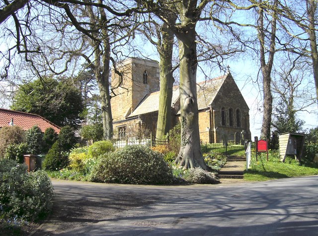
Holy Trinity Church, Swallow
Beelsby Road, Swallow
Beelsby Road Junction
Mog's Hollow
Mog's Hollow
Direction Sign – Signpost on Beelsby Road, Swallow Located on the north side of the junction of Beelsby Road and a minor road to Thorganby in Swallow parish. 3 arms and no finial. Repainted since <a title="https://www.geograph.org.uk/photo/6523911" href="https://www.geograph.org.uk/photo/6523911">Link</a>. See also <a title="https://www.geograph.org.uk/photo/4348864" href="https://www.geograph.org.uk/photo/4348864">Link</a>.

Milestone Society National ID: LI_TA1802
Direction Sign – Signpost on Beelsby Road, Swallow
Located on the north side of the junction of Beelsby Road and a minor road to Thorganby in Swallow parish. 3 arms and no finial. Repainted since Link. See also Link. Milestone Society National ID: LI_TA1802
Cuxwold Hall: aerial 2022
Soilmarks on field near Swallow Vale: aerial 2022
Cutting on Caistor Road near Swallow: aerial 2022
Swallow: aerial 2022 (1)
Swallow: aerial 2022 (2)
Road to Cuxwold
Road to Cuxwold
St Nicholas' church and Commonwealth War Grave site, Cuxwold, Lincs Norman or Anglo-Saxon tower and a James Fowler restoration of 1862.

Now undergoing maintenance.
St Nicholas' church and Commonwealth War Grave site, Cuxwold, Lincs
Norman or Anglo-Saxon tower and a James Fowler restoration of 1862. Now undergoing maintenance.
Grave of J W Baxter, RAF Flight Engineer, St Nicholas' church, Cuxwold, Lincs
St Nicholas' church, Cuxwold, Lincs (1) Norman or Anglo-Saxon tower and a James Fowler restoration of 1862.

Now undergoing maintenance.
St Nicholas' church, Cuxwold, Lincs (1)
Norman or Anglo-Saxon tower and a James Fowler restoration of 1862. Now undergoing maintenance.
St Nicholas' church, Cuxwold, Lincs (2) Norman or Anglo-Saxon tower and a James Fowler restoration of 1862.

Now undergoing maintenance.
St Nicholas' church, Cuxwold, Lincs (2)
Norman or Anglo-Saxon tower and a James Fowler restoration of 1862. Now undergoing maintenance.
St Nicholas' church, Cuxwold, Lincs (3) Norman or Anglo-Saxon tower and a James Fowler restoration of 1862.

Now undergoing maintenance.
St Nicholas' church, Cuxwold, Lincs (3)
Norman or Anglo-Saxon tower and a James Fowler restoration of 1862. Now undergoing maintenance.
Show me another place!

Swallow is located at Grid Ref: TA1703 (Lat: 53.510806, Lng: -0.226879)

Division: Parts of Lindsey

Administrative County: Lincolnshire

District: West Lindsey

Police Authority: Lincolnshire

What 3 Words

///newlyweds.ends.career. Near Laceby, Lincolnshire

Nearby Locations

Swallow

Related Wikis

Swallow, Lincolnshire

Swallow is a small village and civil parish in the West Lindsey district of Lincolnshire, England, on the A46 road 4 miles (6.4 km) north-east from Caistor...

Cuxwold

Cuxwold is a village and former civil parish, now in the parish of Swallow, in the West Lindsey district of Lincolnshire, England. It lies in the Lincolnshire...

Irby upon Humber

Irby upon Humber or Irby-on-Humber is a small village and (as just Irby) a civil parish in North East Lincolnshire, England. The village is situated on...

Beelsby

Beelsby is a village in North East Lincolnshire, England. The village is situated approximately 6 miles (10 km) south-west from Grimsby. Beelsby population...

Nearby Amenities

Located within 500m of 53.510806,-0.226879
Swallow
Is In District: We
Place: village
Wikidata: Q7653083
Lat/Long: 53.5102865/-0.2263426
Bus Stop
Caistor Road
Naptan AtcoCode: 270000007927
Naptan Bearing: NW
Naptan CommonName: Caistor Road
Naptan Indicator: NW - bound
Naptan Landmark: Caistor Road
Naptan NaptanCode: lingmjmp
Naptan Street: Cuxwold Road
Naptan Verified: no
Source: naptan_import
Lat/Long: 53.5106365/-0.2267402
Bus Stop
Layby
Naptan AtcoCode: 270000014349
Naptan Bearing: NE
Naptan CommonName: Layby
Naptan Indicator: NE - bound
Naptan Landmark: Layby
Naptan NaptanCode: linjpjpj
Naptan Street: Caistor Road
Naptan Verified: no
Shelter: yes
Source: naptan_import
Lat/Long: 53.5134347/-0.2277567
Bus Stop
Layby
Naptan AtcoCode: 270000014350
Naptan Bearing: SW
Naptan CommonName: Layby
Naptan Indicator: SW - bound
Naptan Landmark: Layby
Naptan NaptanCode: linjpjpm
Naptan Street: Caistor Road
Naptan Verified: no
Source: naptan_import
Lat/Long: 53.512386/-0.2298597
Bus Stop
Caistor Road
Naptan AtcoCode: 2700LSV02950
Naptan Bearing: SE
Naptan CommonName: Caistor Road
Naptan Indicator: SE - bound
Naptan Landmark: Caistor Road
Naptan NaptanCode: linawawp
Naptan Street: Cuxwold Road
Naptan Verified: no
Source: naptan_import
Lat/Long: 53.5106154/-0.2265299
Millennium Milepost Swallow
Description: 1) Great Limber 5, Melton Ross 12 2) Beelsby 2.25, Thoresway 6.5
Image: https://www.cyclestreets.net/location/197151/cyclestreets197151-size640.jpg
Information: guidepost
Ncn Milepost: mccoll
Source: survey
Sustrans Ref: MP 734
Tourism: information
Lat/Long: 53.5108942/-0.2270618
Pub
Swallow Inn
Addr City: Market Rasen
Addr Country: GB
Addr Postcode: LN7 6DL
Addr Street: Caistor Road
Addr Suburb: Swallow
Lat/Long: 53.5106825/-0.2334807
Rookery Farm
Place: farm
Source: Bing
Lat/Long: 53.5109609/-0.2215089
Leisure: playground
Lat/Long: 53.5104269/-0.2260775
Defibrillator
Defibrillator Location: outside Swallow and Cuxwold Village Hall, Limber Road, Swallow
Emergency: defibrillator
Indoor: no
Ref GB The Circuit: C24CCF25-8070-4660-8DAE-D2A562D39579
Lat/Long: 53.5111681/-0.2275599
Advertising: board
Lat/Long: 53.5111302/-0.2273586
The data included in this document is from www.openstreetmap.org. The data is made available under ODbL.

Have you been to Swallow?

Leave your review of Swallow below (or comments, questions and feedback).