Swalcliffe

Settlement in Oxfordshire Cherwell

England

Swalcliffe

Jester's Hill Small hill above Shutford. As well as the survey pillar there is one of the twee beacons so popular on small English hills. This one was erected to celebrate VE day in 1945.
Jester's Hill Credit: Richard Webb

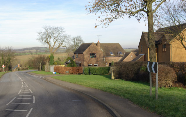
Swalcliffe is a picturesque village located in the county of Oxfordshire, England. Situated approximately 12 miles northwest of Banbury, it is nestled within the beautiful countryside of the Cherwell Valley. The village is known for its idyllic setting and tranquil ambiance, making it a popular destination for those seeking a peaceful retreat.

With a population of just over 300 residents, Swalcliffe is a small and close-knit community. It is home to a charming 12th-century church, St. Peter and St. Paul, which is a notable landmark in the area. The church features stunning architectural details and is renowned for its medieval wall paintings, adding to the village's historical appeal.

Surrounded by rolling hills and lush green fields, Swalcliffe offers ample opportunities for outdoor activities and scenic walks. The nearby Swalcliffe Lea Nature Reserve is a haven for wildlife enthusiasts, boasting a diverse range of plant and animal species. Visitors can explore the reserve's woodland trails and enjoy the tranquil surroundings.

Despite its small size, the village has a strong sense of community and hosts various events throughout the year. Swalcliffe Village Hall serves as a hub for social gatherings and local activities, fostering a sense of belonging among residents.

In conclusion, Swalcliffe is a charming village in Oxfordshire, offering a peaceful escape from the hustle and bustle of city life. With its rich history, stunning natural surroundings, and strong community spirit, it is a hidden gem that attracts visitors seeking a quintessential English village experience.

If you have any feedback on the listing, please let us know in the comments section below.

Swalcliffe Images

Images are sourced within 2km of 52.037791/-1.449708 or Grid Reference SP3737. Thanks to Geograph Open Source API. All images are credited.

Jester's Hill Small hill above Shutford. As well as the survey pillar there is one of the twee beacons so popular on small English hills. This one was erected to celebrate VE day in 1945.
Jester's Hill
Small hill above Shutford. As well as the survey pillar there is one of the twee beacons so popular on small English hills. This one was erected to celebrate VE day in 1945.
St. Nicholas, Tadmarton
SS Peter & Paul, Swalcliffe
Upper Lea Farm
Upper Lea Farm
B4035 west of Tadmarton The B4035 approaches Tadmarton from the west via a double bend past a small development of modern houses.
B4035 west of Tadmarton
The B4035 approaches Tadmarton from the west via a double bend past a small development of modern houses.
The Lampet Arms, Tadmarton Village pub on the B4035 Shipston on Stour - Banbury road.
The Lampet Arms, Tadmarton
Village pub on the B4035 Shipston on Stour - Banbury road.
Tadmarton View across fields to Tadmarton's fine Norman and medieval church.
Tadmarton
View across fields to Tadmarton's fine Norman and medieval church.
Home Farm, Tadmarton Farm in Tadmarton village. A herd of cows stands at the gate, presumably waiting to be milked.
Home Farm, Tadmarton
Farm in Tadmarton village. A herd of cows stands at the gate, presumably waiting to be milked.
Road to Swalcliffe Lea
Village end
Village end
Open road
Open road
Bridleway
Bridleway
Farmland Swalcliffe church in the distance
Farmland
Swalcliffe church in the distance
Blenheim Farm
Blenheim Farm
Farmland Bridleway and entrance road to Blenheim Farm
Farmland
Bridleway and entrance road to Blenheim Farm
Bikes this way! National cycle route 5
Bikes this way!
National cycle route 5
Cycleway 5
Cycleway 5
Show me another place!

Swalcliffe is located at Grid Ref: SP3737 (Lat: 52.037791, Lng: -1.449708)

Administrative County: Oxfordshire

District: Cherwell

Police Authority: Thames Valley

What 3 Words

///bluffing.lanes.editor. Near Hook Norton, Oxfordshire

Related Wikis

Swalcliffe Park School

Swalcliffe Park School is a specialist residential and day school in Oxfordshire, England for boys aged 11–19 who have needs arising from their Autistic...

Swalcliffe

Swalcliffe is a village and civil parish about 5 miles (8 km) west of Banbury in Oxfordshire. The parish is about 2+1⁄2 miles (4 km) long north–south and...

Sibford

Sibford (or The Sibfords) is the collective name given to the villages of Sibford Gower, Sibford Ferris and Burdrop on the edge of the Cotswolds in north...

Sibford Gower

Sibford Gower is a village and civil parish about 6.5 miles (10.5 km) west of Banbury in Oxfordshire, on the north side of the Sib valley, opposite Sibford...

Tadmarton

Tadmarton is a village and civil parish about 4 miles (6.4 km) west of Banbury, Oxfordshire. The 2011 Census recorded the parish's population as 541, which...

Banbury Rural District

Banbury was a rural district in Oxfordshire, England from 1894 to 1974. It was formed under the Local Government Act 1894 from the bulk of the Banbury...

Burdrop

Burdrop is a village in Sibford Gower civil parish, about 6.5 miles (10.5 km) west of Banbury in Oxfordshire, England. Burdrop is contiguous with Sibford...

Sibford Ferris

Sibford Ferris is a village and civil parish about 6.5 miles (10.5 km) west of Banbury in Oxfordshire. It is on the south side of the Sib valley opposite...

Nearby Amenities

Located within 500m of 52.037791,-1.449708
Church
Naptan AtcoCode: 340000735CH
Naptan Bearing: E
Naptan BusStopType: CUS
Naptan CommonName: Church
Naptan Indicator: Outside
Naptan Landmark: Church
Naptan NaptanCode: oxfapawj
Naptan Street: Swalcliffe Rd B4035
Naptan Verified: no
Source: naptan_import
Lat/Long: 52.0378986/-1.4495599
Church
Naptan AtcoCode: 340000735OCH
Naptan Bearing: W
Naptan BusStopType: CUS
Naptan CommonName: Church
Naptan Indicator: Opposite
Naptan Landmark: Church
Naptan NaptanCode: oxfgapgj
Naptan Street: Swalcliffe Rd B4035
Naptan Verified: no
Source: naptan_import
Lat/Long: 52.0377818/-1.4495614
Swalcliffe
Place: village
Lat/Long: 52.0377301/-1.4495419
Pub
The Stag's Head
Wikidata: Q26298407
Lat/Long: 52.0375843/-1.4494233
Power: pole
Lat/Long: 52.0373438/-1.4476723
Power: pole
Lat/Long: 52.0374962/-1.4463186
Power: pole
Lat/Long: 52.037779/-1.4457623
Power: pole
Lat/Long: 52.0383105/-1.4447419
Material: wood
Power: pole
Lat/Long: 52.0388491/-1.4439153
Power: pole
Lat/Long: 52.0395687/-1.4436117
Power: pole
Lat/Long: 52.0412205/-1.4457822
Power: pole
Lat/Long: 52.0410638/-1.4469137
Power: pole
Lat/Long: 52.04092/-1.4479016
Power: pole
Lat/Long: 52.0407825/-1.4488733
Power: pole
Lat/Long: 52.0406437/-1.4498327
Power: pole
Lat/Long: 52.0404987/-1.4508633
Power: pole
Lat/Long: 52.0404436/-1.451957
Power: pole
Lat/Long: 52.0403711/-1.4531725
Power: pole
Lat/Long: 52.0394233/-1.4518513
Power: pole
Lat/Long: 52.0402353/-1.4556265
Power: pole
Lat/Long: 52.0388445/-1.4539149
Power: pole
Lat/Long: 52.0395085/-1.4541756
Power: pole
Lat/Long: 52.0398227/-1.4542625
Power: pole
Lat/Long: 52.0403029/-1.4544045
Power: pole
Lat/Long: 52.0382048/-1.4536517
Power: pole
Lat/Long: 52.0404814/-1.4470685
Power: pole
Lat/Long: 52.0397144/-1.447281
Power: pole
Lat/Long: 52.0390436/-1.4470428
Defibrillator
Access: yes
Booth: KX300
Colour: green
Covered: booth
Defibrillator Location: inside old phone box painted dark green, near church, Swalcliffe
Disused Amenity: telephone
Emergency: defibrillator
Man Made: telephone_box
Lat/Long: 52.037838/-1.4502329
The data included in this document is from www.openstreetmap.org. The data is made available under ODbL.

Have you been to Swalcliffe?

Leave your review of Swalcliffe below (or comments, questions and feedback).