Bolsover

Settlement in Derbyshire Bolsover

England

Bolsover

Bolsover Castle As viewed across the Fountain Garden from the Wall Walk. On the left is the Terrace Range with its spectacular views over the Derbyshire countryside. To the right is the Little Castle <a href="https://www.geograph.org.uk/photo/4665188">SK4770 : Bolsover Little Castle</a>
Bolsover Castle Credit: Graham Hogg

Bolsover is a small town located in the county of Derbyshire, in the East Midlands region of England. It lies about 19 miles south of Sheffield and approximately 145 miles north of London. With a population of around 11,000 people, it is a relatively small community.

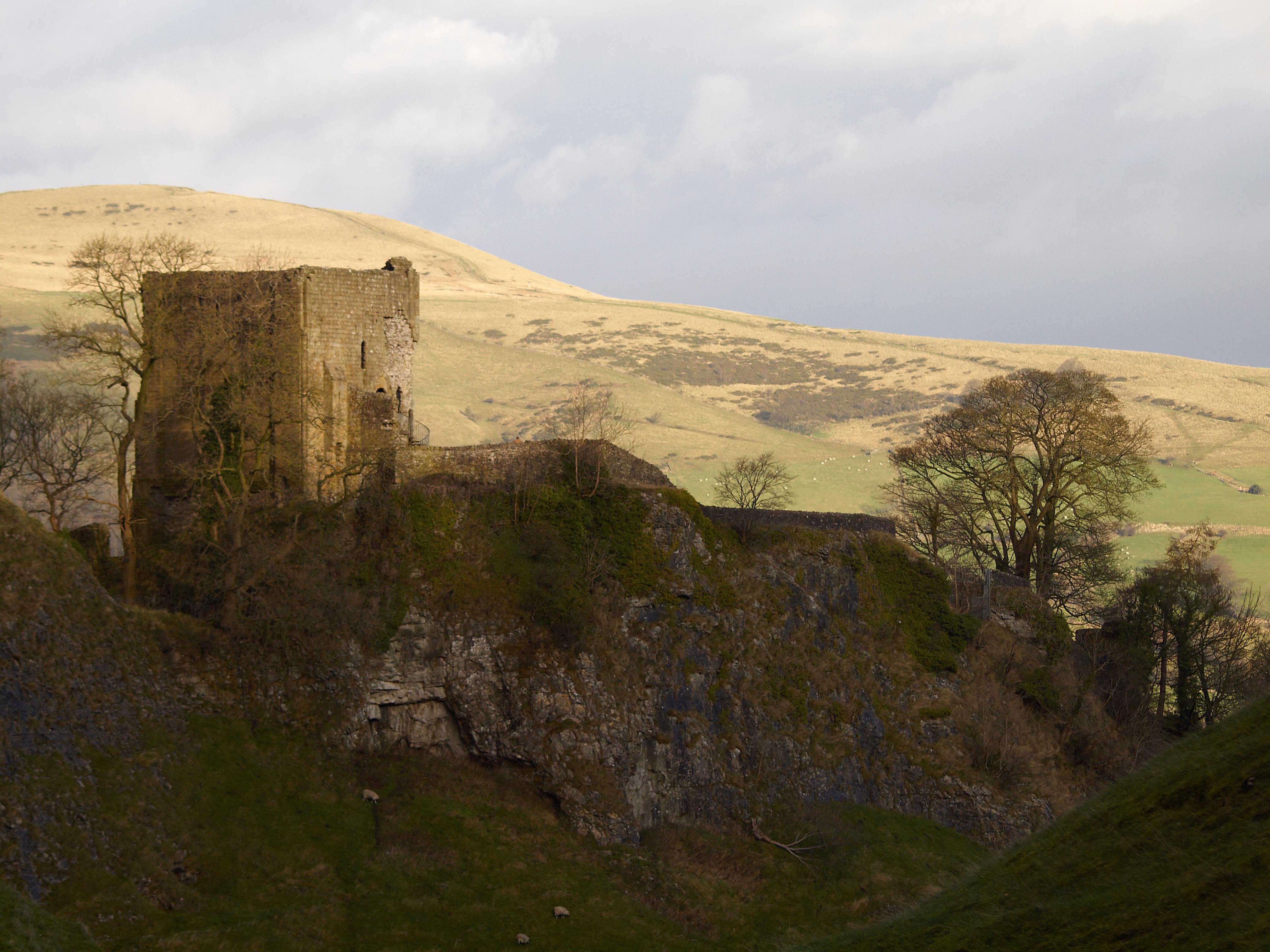
The town is known for its rich historical heritage, particularly Bolsover Castle, a stunning 17th-century mansion. The castle was built by Sir Charles Cavendish and later inherited by his son, William Cavendish, who became the first Duke of Newcastle. Bolsover Castle is renowned for its unique architecture, which blends medieval and classical styles. It is a popular tourist attraction, offering visitors an opportunity to explore its lavish state rooms and enjoy breathtaking views of the surrounding countryside.

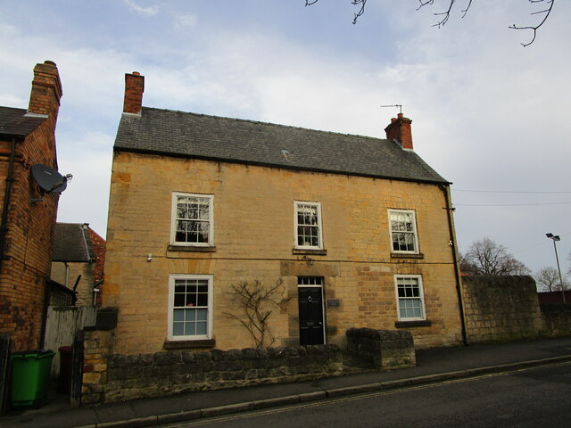
Aside from its historical significance, Bolsover is also home to a number of other landmarks and amenities. The town center features a range of shops, restaurants, and cafes, providing residents and visitors with various options for dining and shopping. Bolsover District Hospital serves the local community, providing healthcare services.

The town enjoys a picturesque setting, surrounded by beautiful countryside and rolling hills. This makes it an ideal location for outdoor activities such as hiking, cycling, and horse riding. Bolsover is well-connected to other parts of Derbyshire and the wider region via road and rail links, making it easily accessible for both residents and tourists.

Overall, Bolsover offers a charming blend of history, natural beauty, and modern amenities, making it an attractive place to visit or call home.

If you have any feedback on the listing, please let us know in the comments section below.

Bolsover Images

Images are sourced within 2km of 53.228012/-1.29238 or Grid Reference SK4770. Thanks to Geograph Open Source API. All images are credited.

Bolsover Castle As viewed across the Fountain Garden from the Wall Walk. On the left is the Terrace Range with its spectacular views over the Derbyshire countryside. To the right is the Little Castle <a href="https://www.geograph.org.uk/photo/4665188">SK4770 : Bolsover Little Castle</a>
Bolsover Castle
As viewed across the Fountain Garden from the Wall Walk. On the left is the Terrace Range with its spectacular views over the Derbyshire countryside. To the right is the Little Castle SK4770 : Bolsover Little Castle
The Indoor Riding School at Bolsover Castle Viewed from the visitor centre.
The Indoor Riding School at Bolsover Castle
Viewed from the visitor centre.
Large beech tree at Bolsover Castle The centrepiece of the Great Court between the Riding School and the Little Castle.
Large beech tree at Bolsover Castle
The centrepiece of the Great Court between the Riding School and the Little Castle.
Looking through a window at Bolsover Castle On the Terrace Range which enjoys dramatic views over the Derbyshire countryside.
Looking through a window at Bolsover Castle
On the Terrace Range which enjoys dramatic views over the Derbyshire countryside.
The Little Castle Viewd from the Wall Walk at Bolsover Castle
The Little Castle
Viewd from the Wall Walk at Bolsover Castle
View west from Hill Top, Bolsover
Church of St. Mary and St. Lawrence, Old Bolsover Partly medieval <span class="nowrap"><a title="https://historicengland.org.uk/listing/the-list/list-entry/1054045?section=official-listing" rel="nofollow ugc noopener" href="https://historicengland.org.uk/listing/the-list/list-entry/1054045?section=official-listing">Link</a><img style="margin-left:2px;" alt="External link" title="External link - shift click to open in new window" src="https://s1.geograph.org.uk/img/external.png" width="10" height="10"/></span>
Church of St. Mary and St. Lawrence, Old Bolsover
Partly medieval LinkExternal link
St. Bernadette's Roman Catholic church, Old Bolsover Designed by John Rochford and Partners 1967.
St. Bernadette's Roman Catholic church, Old Bolsover
Designed by John Rochford and Partners 1967.
2-4 Church Street, Old Bolsover Mid eighteenth century house <span class="nowrap"><a title="https://historicengland.org.uk/listing/the-list/list-entry/1054033?section=official-listing" rel="nofollow ugc noopener" href="https://historicengland.org.uk/listing/the-list/list-entry/1054033?section=official-listing">Link</a><img style="margin-left:2px;" alt="External link" title="External link - shift click to open in new window" src="https://s1.geograph.org.uk/img/external.png" width="10" height="10"/></span>
2-4 Church Street, Old Bolsover
Mid eighteenth century house LinkExternal link
15-19 Cotton Street. Old Bolsover Seventeenth century houses later altered <span class="nowrap"><a title="https://historicengland.org.uk/listing/the-list/list-entry/1108978?section=official-listing" rel="nofollow ugc noopener" href="https://historicengland.org.uk/listing/the-list/list-entry/1108978?section=official-listing">Link</a><img style="margin-left:2px;" alt="External link" title="External link - shift click to open in new window" src="https://s1.geograph.org.uk/img/external.png" width="10" height="10"/></span>
15-19 Cotton Street. Old Bolsover
Seventeenth century houses later altered LinkExternal link
Cotton Street, Old Bolsover
Former Primitive Methodist chapel, Cotton Street, Old Bolsover Built in 1865. At various times it has been a Salvation Army Citadel and Urban District Council offices.
Former Primitive Methodist chapel, Cotton Street, Old Bolsover
Built in 1865. At various times it has been a Salvation Army Citadel and Urban District Council offices.
The Cavendish, Old Bolsover
The White Swan, Old Bolsover Closed.
The White Swan, Old Bolsover
Closed.
Bolsover Assembly Hall Community Centre
Bolsover Methodist church Dates from 1896-7. Designed by John Wills <span class="nowrap"><a title="https://en.wikipedia.org/wiki/John_Wills_(architect)" rel="nofollow ugc noopener" href="https://en.wikipedia.org/wiki/John_Wills_(architect)">Link</a><img style="margin-left:2px;" alt="External link" title="External link - shift click to open in new window" src="https://s1.geograph.org.uk/img/external.png" width="10" height="10"/></span>
Bolsover Methodist church
Dates from 1896-7. Designed by John Wills LinkExternal link
Shops and houses, Town End, Old Bolsover
War memorial, Market Place, Old Bolsover Listed <span class="nowrap"><a title="https://historicengland.org.uk/listing/the-list/list-entry/1187012?section=official-listing" rel="nofollow ugc noopener" href="https://historicengland.org.uk/listing/the-list/list-entry/1187012?section=official-listing">Link</a><img style="margin-left:2px;" alt="External link" title="External link - shift click to open in new window" src="https://s1.geograph.org.uk/img/external.png" width="10" height="10"/></span> Designed by Sir Reginald Blomfield <span class="nowrap"><a title="https://en.wikipedia.org/wiki/Reginald_Blomfield" rel="nofollow ugc noopener" href="https://en.wikipedia.org/wiki/Reginald_Blomfield">Link</a><img style="margin-left:2px;" alt="External link" title="External link - shift click to open in new window" src="https://s1.geograph.org.uk/img/external.png" width="10" height="10"/></span>
War memorial, Market Place, Old Bolsover
Listed LinkExternal link Designed by Sir Reginald Blomfield LinkExternal link
Show me another place!

Bolsover is located at Grid Ref: SK4770 (Lat: 53.228012, Lng: -1.29238)

Administrative County: Derbyshire

District: Bolsover

Police Authority: Derbyshire

What 3 Words

///cubic.intrigued.smothered. Near Bolsover, Derbyshire

Nearby Locations

Bolsover

Related Wikis

St Mary and St Laurence's Church, Bolsover

St Mary and St Laurence's Church, Bolsover is a Grade II* listed parish church in the Church of England in Bolsover, Derbyshire. == History == The church...

Over Woodhouse

Over Woodhouse is a suburban area lying just North-West of Bolsover Towncentre, Derbyshire, just to the north of Bolsover Castle, on a hill facing it....

Old Bolsover Town Council

Old Bolsover Town Council is the parish council for the civil parish of Old Bolsover in Derbyshire, England. It has responsibility for local issues in...

Bolsover

Bolsover is a market town and the administrative centre of the Bolsover District, Derbyshire, England. It is 18 miles (29 km) from Sheffield, 26 miles...

Bolsover Urban District

Bolsover was an Urban District in Derbyshire, England from 1894 to 1974. It was created under the Local Government Act 1894. The district was abolished...

Honour of Peverel

The Honour of Peverel (also known as the Feudal Barony of the Peak) is a geographic area in the north of England comprising part of the historic feudal...

Bolsover Castle

Bolsover Castle is in the town of Bolsover (grid reference SK471707), in the north-east of the English county of Derbyshire. Built in the early 17th century...

Bolsover (UK Parliament constituency)

Bolsover (, and commonly ) is a constituency in Derbyshire, represented in the House of Commons of the UK Parliament by Mark Fletcher, a member of the...

Nearby Amenities

Located within 500m of 53.228012,-1.29238
Bolsover
Created By: Potlatch 0.9
Place: town
Wikidata: Q2130058
Lat/Long: 53.228666/-1.2912756
Post Box
Collection Times: Mo-Fr 09:00; Sa 07:00
Post Box Type: lamp
Ref: S44 221D
Royal Cypher: EIIR
Royal Cypher Wikidata: Q33102113
Lat/Long: 53.2248195/-1.2874096
Ele: 164.99
Lat/Long: 53.2271096/-1.2873811
Ele: 107.31
Lat/Long: 53.2252303/-1.295811
Ele: 112.36
Lat/Long: 53.2253967/-1.2950187
Ele: 113.8
Lat/Long: 53.2239303/-1.2937091
Ele: 98
Lat/Long: 53.2254635/-1.2980834
Pub
Blue Bell
Addr Street: High Street
Ele: 173
Food: yes
Real Ale: 6 or so beers including 3 or so from Marston's list
Lat/Long: 53.2278197/-1.2922759
Bench
Ele: 153.21
Lat/Long: 53.229417/-1.2960338
Place Of Worship
St Bernadette
Addr Street: High Street
Denomination: catholic
Ele: 174
Religion: christian
Lat/Long: 53.2276151/-1.2920626
Place Of Worship
Addr Street: High Street
Denomination: jehovahs_witness
Religion: christian
Lat/Long: 53.2279932/-1.2918815
Post Box
Collection Times: Mo-Fr 16:00; Sa 10:30
Ele: 167.63
Post Box Apertures: 2
Post Box Type: pillar
Ref: S44 116;S44 116
Royal Cypher: EIIR
Royal Cypher Wikidata: Q33102113
Lat/Long: 53.2287331/-1.2916846
Ele: 168
Lat/Long: 53.2283653/-1.2909343
Crossing
Crossing: traffic_signals
Crossing Island: no
Tactile Paving: yes
Lat/Long: 53.2305047/-1.2933526
Bicycle Parking
Capacity: 6
Lat/Long: 53.2290911/-1.2925547
Artwork Type: sculpture
Tourism: artwork
Lat/Long: 53.2312922/-1.2964372
Entrance: yes
Lat/Long: 53.2302168/-1.2944579
Toilets
Lat/Long: 53.2303005/-1.2941666
Bench
Lat/Long: 53.2304019/-1.2944066
Entrance: yes
Lat/Long: 53.230183/-1.2942898
Cafe
Lat/Long: 53.2302321/-1.294305
Turning Circle
Lat/Long: 53.2244252/-1.2881478
Post Box
Brand: Royal Mail
Brand Wikidata: Q638098
Brand Wikipedia: en:Royal Mail
Collection Times: Mo-Fr 09:00; Sa 07:00
Operator: Royal Mail
Operator Wikidata: Q638098
Post Box Type: pillar
Ref: S44 143D
Royal Cypher: EIIR
Royal Cypher Wikidata: Q33102113
Lat/Long: 53.2296995/-1.291815
Post Box
Brand: Royal Mail
Brand Wikidata: Q638098
Brand Wikipedia: en:Royal Mail
Collection Times: Mo-Fr 09:00; Sa 07:00
Operator: Royal Mail
Operator Wikidata: Q638098
Post Box Type: lamp
Ref: S44 168D
Royal Cypher: EIIR
Royal Cypher Wikidata: Q33102113
Lat/Long: 53.2277913/-1.2854625
Post Office
Bolsover Post Office
Addr City: Chesterfield
Addr Country: GB
Addr Housenumber: 10
Addr Postcode: S44 6HA
Addr Street: Cotton Street
Addr Suburb: Bolsover
Brand: Post Office
Brand Wikidata: Q1783168
Opening Hours: Mo-Fr 08:30-17:30; Sa 08:30-13:30
Ref Pol Id: 15013
Website: https://www.postoffice.co.uk/branch-finder/4333403/bolsover
Lat/Long: 53.2286273/-1.2915985
Post Box
Brand: Royal Mail
Brand Wikidata: Q638098
Collection Times: Mo-Fr 09:00; Sa 07:00
Operator: Royal Mail
Operator Wikidata: Q638098
Post Box Type: lamp
Ref: S44 325D
Royal Cypher: EIIR
Royal Cypher Wikidata: Q33102113
Lat/Long: 53.2256112/-1.295206
Operator: English Heritage
Shop: gift
Source: survey
Lat/Long: 53.2301891/-1.2944095
Bicycle Parking
Source: survey
Lat/Long: 53.2301972/-1.2942002
Toilets
Access: customers
Operator: English Heritage
Lat/Long: 53.230435/-1.2962615
Entrance: yes
Lat/Long: 53.2305887/-1.2960831
Entrance: yes
Wheelchair: no
Lat/Long: 53.2309154/-1.2954836
Entrance: yes
Lat/Long: 53.2312656/-1.2958737
Entrance: yes
Wheelchair: no
Lat/Long: 53.2313398/-1.2969847
White Swan
Disused Amenity: pub
Note: Still boarded up
Source: survey
Lat/Long: 53.2297788/-1.2918265
Place Of Worship
Bolsover Methodist Church
Denomination: methodist
Religion: christian
Lat/Long: 53.2308679/-1.2926692
North Star Club
Club: yes
Old Name: Welbeck Road Social Club
Lat/Long: 53.2306337/-1.2884889
Bench
Lat/Long: 53.2273454/-1.2884326
Pub
Cavendish
Brand: Marston's
Brand Wikidata: Q6773982
Bt Sport: yes
Operator: Marston's
Outdoor Seating: yes
Real Ale: 2 from Marston's
Website: https://www.cavendishhotelchesterfield.co.uk/
Lat/Long: 53.229494/-1.2911096
Barrier: cycle_barrier
Lat/Long: 53.2255093/-1.2980377
Black Bull
Disused Amenity: pub
Note: Appears to be shut May 2018
Lat/Long: 53.2300513/-1.2923087
Bench
Lat/Long: 53.2277271/-1.2933359
Surprise View
Information: board
Tourism: information
Lat/Long: 53.2276676/-1.2929474
Bench
Lat/Long: 53.227736/-1.2934016
Fast Food
Jade Palace
Cuisine: chinese;fish_and_chips
Lat/Long: 53.2290722/-1.2912131
Barrier: cycle_barrier
Lat/Long: 53.227677/-1.2929062
Bench
Lat/Long: 53.2276581/-1.2930811
Information: board
Tourism: information
Lat/Long: 53.2314865/-1.290639
Traffic Signals
Traffic Signals: signal
Traffic Signals Direction: both
Lat/Long: 53.229315/-1.2910232
Barrier: cycle_barrier
Lat/Long: 53.2263282/-1.2969516
Barrier: cycle_barrier
Lat/Long: 53.2265131/-1.2972301
Brand Wikipedia: en:Fulton's Foods
Shop: vacant
Lat/Long: 53.2292363/-1.2911049
Pharmacy
Rowlands Pharmacy
Brand: Rowlands Pharmacy
Brand Wikidata: Q62663235
Healthcare: pharmacy
Website: https://rowlandspharmacy.co.uk/find-local-pharmacy#!/l/bolsover/2-town-end/1065
Lat/Long: 53.2294289/-1.2907214
Shop: vacant
Lat/Long: 53.2296329/-1.290429
Bench
Lat/Long: 53.2300106/-1.2929833
Cafe
Beans
Tourism: art_gallery
Lat/Long: 53.2298697/-1.2924349
Oven Door
Shop: yes
Lat/Long: 53.2296176/-1.2914532
Bolsover Express
Shop: deli
Lat/Long: 53.2296867/-1.2916299
Betfred
Brand: Betfred
Brand Wikidata: Q4897425
Brand Wikipedia: en:Betfred
Shop: bookmaker
Lat/Long: 53.229653/-1.2915468
Bench
Lat/Long: 53.2313865/-1.292369
Fast Food
Pizza Hot
Cuisine: pizza
Lat/Long: 53.2292521/-1.292093
Funky Monkey
Shop: tattoo
Lat/Long: 53.2293115/-1.2920367
Elliott Meats
Addr City: Chesterfield
Addr Housenumber: 40
Addr Postcode: S44 6PN
Addr Street: Market Place
Addr Suburb: Bolsover
Shop: butcher
Lat/Long: 53.2291782/-1.2921616
Parker
Shop: optician
Lat/Long: 53.2288272/-1.2892935
Bank
TSB
Brand: TSB
Brand Wikidata: Q7671560
Brand Wikipedia: en:TSB Bank (United Kingdom)
Website: https://branches.tsb.co.uk/chesterfield/bolsover/bolsover.html
Lat/Long: 53.2289911/-1.2912676
Entire FM
Addr City: Chesterfield
Addr Housenumber: 21
Addr Postcode: S44 6BE
Addr Street: Station Road
Office: yes
Website: EntireFM
Lat/Long: 53.2310969/-1.2936139
Serenity Beauty & Co
Shop: hairdresser
Website: https://serenitybeautyandco.com/
Lat/Long: 53.2308192/-1.2933806
Simon Cresswell
Craft: joiner
Lat/Long: 53.2304435/-1.2930748
Doctors
The Friendly Familiy Surgery
Healthcare: doctor
Lat/Long: 53.2292137/-1.2889227
Hidden Dragon
Shop: tattoo
Lat/Long: 53.2296054/-1.2888476
Traffic Signals
Crossing: no
Traffic Signals Direction: backward
Lat/Long: 53.2287495/-1.2891305
Waste Basket
Lat/Long: 53.2301974/-1.2931681
Stubbins and Hope
Shop: funeral_directors
Lat/Long: 53.2279378/-1.292394
Bench
Backrest: yes
Material: wood
Lat/Long: 53.2311746/-1.2972893
Bench
Backrest: yes
Material: wood
Lat/Long: 53.2312437/-1.297523
Bench
Backrest: yes
Material: wood
Lat/Long: 53.2310195/-1.2974009
Tourism: picnic_site
Lat/Long: 53.2305059/-1.2946272
Bolsover Memorial Cross
Historic: memorial
Memorial: war_memorial
Lat/Long: 53.2292953/-1.2924117
Waste Basket
Lat/Long: 53.2304356/-1.2947972
Cafe
Mason's little Café
Addr City: Chesterfield
Addr Housenumber: 6
Addr Postcode: S44 6DT
Addr Street: Town End
Addr Suburb: Bolsover
Contact Phone: +44 7718 767811
Fhrs Id: 1043811
Opening Hours: Mo-Su 08:00-14:00
Lat/Long: 53.2292849/-1.2903866
Direction: 175
Generator Method: photovoltaic
Generator Output Electricity: yes
Generator Solar Modules: 14
Generator Source: solar
Generator Type: solar_photovoltaic_panel
Location: roof
Power: generator
Lat/Long: 53.2245222/-1.2886252
Generator Method: photovoltaic
Generator Output Electricity: yes
Generator Source: solar
Generator Type: solar_photovoltaic_panel
Location: roof
Power: generator
Lat/Long: 53.2239474/-1.295586
Direction: SSW
Generator Method: photovoltaic
Generator Output Electricity: yes
Generator Solar Modules: 18
Generator Source: solar
Generator Type: solar_photovoltaic_panel
Location: roof
Power: generator
Lat/Long: 53.2239995/-1.29481
Direction: WSW
Generator Method: photovoltaic
Generator Output Electricity: yes
Generator Solar Modules: 18
Generator Source: solar
Generator Type: solar_photovoltaic_panel
Location: roof
Power: generator
Lat/Long: 53.2242121/-1.2944753
Direction: WSW
Generator Method: photovoltaic
Generator Output Electricity: yes
Generator Solar Modules: 13
Generator Source: solar
Generator Type: solar_photovoltaic_panel
Location: roof
Power: generator
Lat/Long: 53.2244741/-1.2941376
Direction: WSW
Generator Method: photovoltaic
Generator Output Electricity: yes
Generator Solar Modules: 14
Generator Source: solar
Generator Type: solar_photovoltaic_panel
Location: roof
Power: generator
Lat/Long: 53.224143/-1.2944105
Direction: SW
Generator Method: photovoltaic
Generator Output Electricity: yes
Generator Solar Modules: 18
Generator Source: solar
Generator Type: solar_photovoltaic_panel
Location: roof
Power: generator
Lat/Long: 53.2256809/-1.2961238
Direction: SSE
Generator Method: photovoltaic
Generator Output Electricity: yes
Generator Solar Modules: 10
Generator Source: solar
Generator Type: solar_photovoltaic_panel
Location: roof
Power: generator
Lat/Long: 53.2250598/-1.2951773
Direction: 235
Generator Method: photovoltaic
Generator Output Electricity: yes
Generator Solar Modules: 20
Generator Source: solar
Generator Type: solar_photovoltaic_panel
Location: roof
Power: generator
Lat/Long: 53.2248072/-1.2938033
Direction: SW
Generator Method: photovoltaic
Generator Output Electricity: yes
Generator Solar Modules: 10
Generator Source: solar
Generator Type: solar_photovoltaic_panel
Location: roof
Power: generator
Lat/Long: 53.2246503/-1.2917901
Direction: SW
Generator Method: photovoltaic
Generator Output Electricity: yes
Generator Solar Modules: 16
Generator Source: solar
Generator Type: solar_photovoltaic_panel
Location: roof
Power: generator
Lat/Long: 53.2239522/-1.2922757
Direction: WSW
Generator Method: photovoltaic
Generator Output Electricity: yes
Generator Solar Modules: 17
Generator Source: solar
Generator Type: solar_photovoltaic_panel
Location: roof
Power: generator
Lat/Long: 53.2243761/-1.2899958
Direction: SW
Generator Method: photovoltaic
Generator Output Electricity: yes
Generator Solar Modules: 16
Generator Source: solar
Generator Type: solar_photovoltaic_panel
Location: roof
Power: generator
Lat/Long: 53.2245238/-1.2902104
Direction: SW
Generator Method: photovoltaic
Generator Output Electricity: yes
Generator Solar Modules: 18
Generator Source: solar
Generator Type: solar_photovoltaic_panel
Location: roof
Power: generator
Lat/Long: 53.2247661/-1.2905866
Direction: SW
Generator Method: photovoltaic
Generator Output Electricity: yes
Generator Solar Modules: 16
Generator Source: solar
Generator Type: solar_photovoltaic_panel
Location: roof
Power: generator
Lat/Long: 53.2248273/-1.2906957
Direction: SE
Generator Method: photovoltaic
Generator Output Electricity: yes
Generator Solar Modules: 18
Generator Source: solar
Generator Type: solar_photovoltaic_panel
Location: roof
Power: generator
Lat/Long: 53.2262496/-1.2973411
Direction: SE
Generator Method: photovoltaic
Generator Output Electricity: yes
Generator Source: solar
Generator Type: solar_photovoltaic_panel
Location: roof
Power: generator
Lat/Long: 53.2266703/-1.2980653
Direction: 215
Generator Method: photovoltaic
Generator Output Electricity: yes
Generator Solar Modules: 18
Generator Source: solar
Generator Type: solar_photovoltaic_panel
Location: roof
Power: generator
Lat/Long: 53.2266903/-1.2987377
Generator Method: photovoltaic
Generator Output Electricity: yes
Generator Source: solar
Generator Type: solar_photovoltaic_panel
Location: roof
Power: generator
Lat/Long: 53.2282305/-1.2971641
Generator Method: photovoltaic
Generator Output Electricity: yes
Generator Source: solar
Generator Type: solar_photovoltaic_panel
Location: roof
Power: generator
Lat/Long: 53.2288776/-1.2942673
Generator Method: photovoltaic
Generator Output Electricity: yes
Generator Source: solar
Generator Type: solar_photovoltaic_panel
Location: roof
Power: generator
Lat/Long: 53.2276402/-1.2876219
Generator Method: photovoltaic
Generator Output Electricity: yes
Generator Source: solar
Generator Type: solar_photovoltaic_panel
Location: roof
Power: generator
Lat/Long: 53.2275599/-1.2876058
Generator Method: photovoltaic
Generator Output Electricity: yes
Generator Source: solar
Generator Type: solar_photovoltaic_panel
Location: roof
Power: generator
Lat/Long: 53.2275615/-1.2876809
Generator Method: photovoltaic
Generator Output Electricity: yes
Generator Source: solar
Generator Type: solar_photovoltaic_panel
Location: roof
Power: generator
Lat/Long: 53.2276739/-1.2876541
Generator Method: photovoltaic
Generator Output Electricity: yes
Generator Source: solar
Generator Type: solar_photovoltaic_panel
Location: roof
Power: generator
Lat/Long: 53.2276739/-1.2875817
Generator Method: photovoltaic
Generator Output Electricity: yes
Generator Source: solar
Generator Type: solar_photovoltaic_panel
Location: roof
Power: generator
Lat/Long: 53.2320758/-1.2954569
Generator Method: photovoltaic
Generator Output Electricity: yes
Generator Source: solar
Generator Type: solar_photovoltaic_panel
Location: roof
Power: generator
Lat/Long: 53.2273072/-1.2958887
Generator Method: photovoltaic
Generator Output Electricity: yes
Generator Source: solar
Generator Type: solar_photovoltaic_panel
Location: roof
Power: generator
Lat/Long: 53.2273168/-1.2958324
Generator Method: photovoltaic
Generator Output Electricity: yes
Generator Source: solar
Generator Type: solar_photovoltaic_panel
Location: roof
Power: generator
Lat/Long: 53.227768/-1.2966558
Bus Stop
Bolsover Market Place (Stop 2)
Bench: yes
Bus: yes
Local Ref: 2
Naptan AtcoCode: 1000DBTE7067
Naptan NaptanCode: dbsgjpmg
Public Transport: platform
Shelter: yes
Lat/Long: 53.22942/-1.2915942
Bus Stop
Bolsover Market Place (Stop 1)
Bus: yes
Local Ref: 1
Naptan AtcoCode: 1000DBTE7066
Naptan NaptanCode: dbsgjpmd
Public Transport: platform
Shelter: yes
Lat/Long: 53.2295292/-1.291527
Crossing
Button Operated: yes
Crossing: traffic_signals
Crossing Island: no
Tactile Paving: yes
Traffic Signals Vibration: yes
Lat/Long: 53.2293892/-1.2912564
Traffic Signals
Crossing: no
Traffic Signals Direction: forward
Lat/Long: 53.2284843/-1.2890594
Traffic Signals
Crossing: no
Traffic Signals Direction: backward
Lat/Long: 53.2284457/-1.2894518
Traffic Signals
Crossing: no
Traffic Signals Direction: forward
Lat/Long: 53.2287498/-1.2894238
Crossing
Crossing: traffic_signals
Crossing Island: no
Tactile Paving: yes
Lat/Long: 53.2284731/-1.2894228
Crossing
Crossing: traffic_signals
Crossing Island: no
Tactile Paving: yes
Lat/Long: 53.2285011/-1.2891039
Crossing
Crossing: traffic_signals
Crossing Island: no
Tactile Paving: yes
Lat/Long: 53.2287255/-1.2893954
Crossing
Crossing: traffic_signals
Crossing Island: no
Tactile Paving: yes
Lat/Long: 53.2287318/-1.2891799
Traffic Signals
Crossing: no
Traffic Signals Direction: backward
Lat/Long: 53.2304778/-1.2933257
Traffic Signals
Crossing: no
Traffic Signals Direction: forward
Lat/Long: 53.2305321/-1.2933799
Direction: SW
Generator Method: photovoltaic
Generator Output Electricity: yes
Generator Solar Modules: 16
Generator Source: solar
Generator Type: solar_photovoltaic_panel
Location: roof
Power: generator
Lat/Long: 53.2252754/-1.2889903
Direction: 235
Generator Method: photovoltaic
Generator Output Electricity: yes
Generator Solar Modules: 18
Generator Source: solar
Generator Type: solar_photovoltaic_panel
Location: roof
Power: generator
Lat/Long: 53.2266017/-1.2908132
Direction: 235
Generator Method: photovoltaic
Generator Output Electricity: yes
Generator Solar Modules: 16
Generator Source: solar
Generator Type: solar_photovoltaic_panel
Location: roof
Power: generator
Lat/Long: 53.2253345/-1.2891008
Bus Stop
Bolsover Market Place (Stop 3)
Bench: yes
Bus: yes
Local Ref: 3
Naptan AtcoCode: 1000DBTE7068
Naptan NaptanCode: dbsgjpmj
Public Transport: platform
Shelter: yes
Lat/Long: 53.2294767/-1.291725
Bus Stop
Bus: yes
Naptan AtcoCode: 1000DBRR7078
Naptan NaptanCode: dbsagwdj
Public Transport: platform
Lat/Long: 53.2256352/-1.2952401
Bus Stop
Bus: yes
Naptan AtcoCode: 1000DBNR7081
Naptan NaptanCode: dbsgmamt
Public Transport: platform
Lat/Long: 53.2267174/-1.294131
Bus Stop
Bus: yes
Naptan AtcoCode: 1000DBNR7080
Naptan NaptanCode: dbsgmamp
Public Transport: platform
Lat/Long: 53.2268908/-1.2944944
Bus Stop
Bus: yes
Public Transport: platform
Lat/Long: 53.2280325/-1.2897737
Bus Stop
Bus: yes
Public Transport: platform
Lat/Long: 53.2276286/-1.2918471
Bus Stop
Bus: yes
Public Transport: platform
Lat/Long: 53.2248556/-1.2879793
Bus Stop
Bus: yes
Naptan AtcoCode: 1000DHNL7458
Naptan NaptanCode: dbsapgwd
Public Transport: platform
Lat/Long: 53.224752/-1.2881993
Bus Stop
Bus: yes
Public Transport: platform
Lat/Long: 53.2264774/-1.2899709
Bus Stop
Bus: yes
Naptan AtcoCode: 1000DBLR7071
Naptan NaptanCode: dbsgtdmw
Public Transport: platform
Lat/Long: 53.2265119/-1.2897925
Bus Stop
Bus: yes
Public Transport: platform
Lat/Long: 53.2280501/-1.2900017
Bus Stop
Bus: yes
Public Transport: platform
Lat/Long: 53.2283416/-1.2888511
Bus Stop
Bus: yes
Public Transport: platform
Lat/Long: 53.2283287/-1.2885453
Bus Stop
Bus: yes
Naptan AtcoCode: 1000DBML7123
Naptan NaptanCode: dbsgtdtg
Public Transport: platform
Lat/Long: 53.2280108/-1.2871063
Bus Stop
Bus: yes
Naptan AtcoCode: 1000DBPA7129
Naptan NaptanCode: dbsagtwm
Public Transport: platform
Lat/Long: 53.2258664/-1.2860213
Bus Stop
Bus: yes
Public Transport: platform
Lat/Long: 53.2260278/-1.2862842
Camera Mount: street_lamp
Camera Type: dome
Man Made: surveillance
Surveillance: public
Surveillance Type: camera
Surveillance Zone: town
Lat/Long: 53.2293624/-1.2914271
Camera Mount: street_lamp
Camera Type: dome
Man Made: surveillance
Surveillance: public
Surveillance Type: camera
Surveillance Zone: town
Lat/Long: 53.229392/-1.2911157
Direction: SW
Generator Method: photovoltaic
Generator Output Electricity: yes
Generator Solar Modules: 10
Generator Source: solar
Generator Type: solar_photovoltaic_panel
Location: roof
Power: generator
Lat/Long: 53.224872/-1.2919866
Source: GPS
Lat/Long: 53.2264851/-1.2964187
Source: GPS
Lat/Long: 53.2264821/-1.2963032
Farmfoods
Addr City: Chesterfield
Addr Housenumber: 30
Addr Postcode: S44 6PN
Addr Street: Market Place
Addr Suburb: Bolsover
Brand: Farmfoods
Brand Wikidata: Q5435841
Brand Wikipedia: en:Farmfoods
Fhrs Id: 24274
Shop: frozen_food
Lat/Long: 53.229264/-1.2916942
Crossing
Button Operated: yes
Crossing: traffic_signals
Crossing Island: no
Tactile Paving: yes
Traffic Signals Vibration: yes
Lat/Long: 53.2293897/-1.2909692
Crossing
Button Operated: yes
Crossing: traffic_signals
Crossing Island: no
Tactile Paving: yes
Traffic Signals Vibration: yes
Lat/Long: 53.2292956/-1.2909383
Cafe
The Coffee Cup
Lat/Long: 53.229438/-1.2931099
Dollies
Shop: beauty
Lat/Long: 53.2293934/-1.2929929
No. 5
Shop: deli
Lat/Long: 53.2296102/-1.291955
Cafe
The Pump
Lat/Long: 53.2293683/-1.2928998
Defibrillator
Access: yes
Defibrillator Location: On the outside wall at the Wetherspoons pub
Emergency: defibrillator
Indoor: no
Ref GB The Circuit: 5B3F1437-7588-45E3-95F8-057E56C54364
Lat/Long: 53.2298768/-1.2938692
Defibrillator
Access: yes
Defibrillator Location: On the outside wall of the library.
Emergency: defibrillator
Indoor: no
Lat/Long: 53.2284387/-1.2918267
Defibrillator
Access: yes
Defibrillator Location: On the outside wall of the fire station.
Emergency: defibrillator
Indoor: no
Ref GB The Circuit: 418B3780-D060-4390-A6C9-1CEC0B2C44DD
Lat/Long: 53.2284148/-1.2927959
Building: entrance
Lat/Long: 53.2283712/-1.2916529
The data included in this document is from www.openstreetmap.org. The data is made available under ODbL.

Have you been to Bolsover?

Leave your review of Bolsover below (or comments, questions and feedback).