Hinksey, South

Settlement in Berkshire Vale of White Horse

England

Hinksey, South

Bayworth Lane, Boars Hill
Bayworth Lane, Boars Hill Credit: David Howard

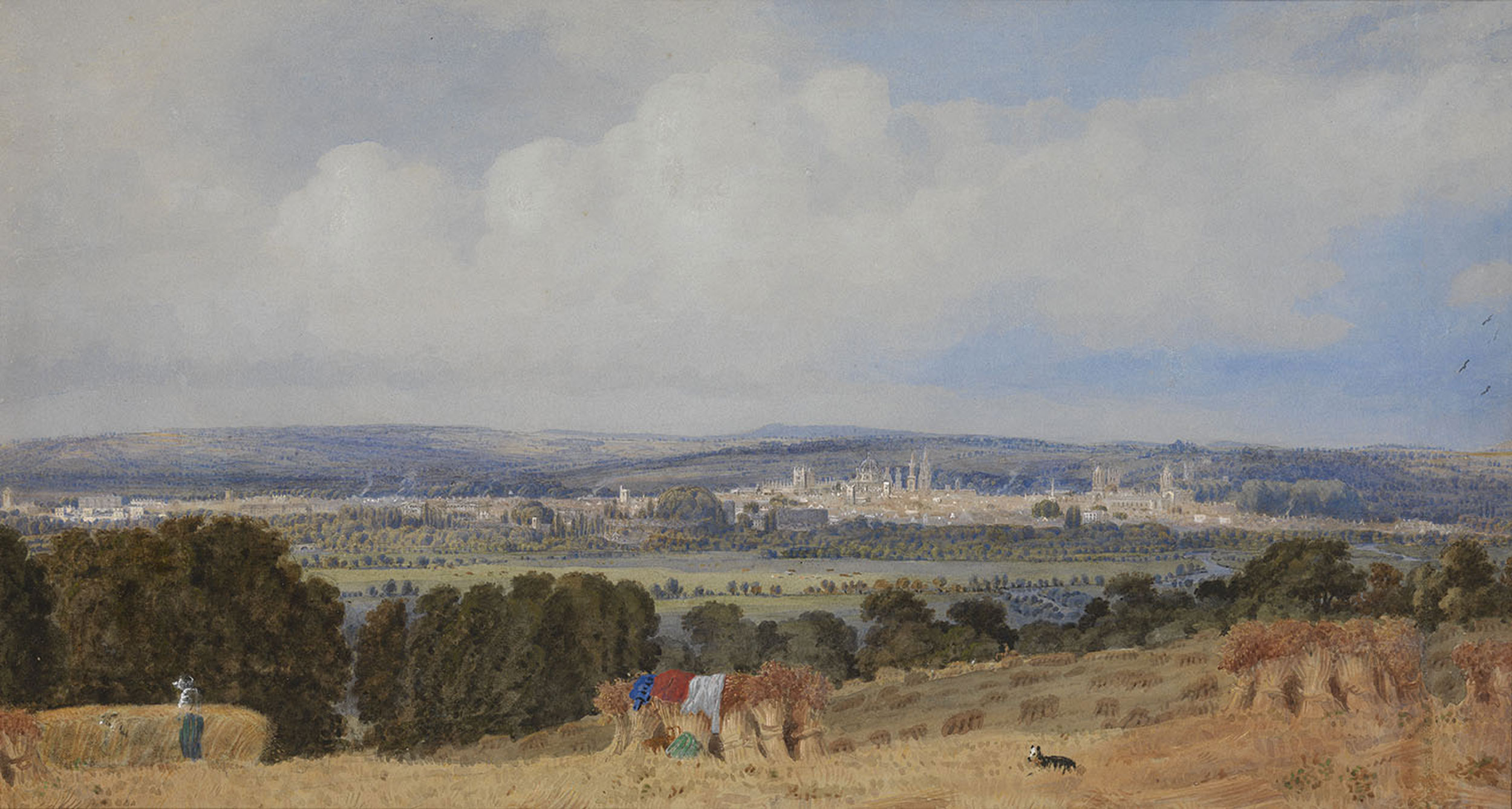
Hinksey is a small village located in the South of Berkshire, England. Situated near the River Thames and just a few miles from the historic city of Oxford, Hinksey offers a picturesque and tranquil setting for its residents.

The village is known for its charming rural character, with traditional thatched cottages and beautiful countryside views. Hinksey is surrounded by open fields and woodlands, providing ample opportunities for outdoor activities such as walking, cycling, and birdwatching.

Despite its rural ambiance, Hinksey benefits from its close proximity to the bustling city of Oxford. Residents have easy access to a range of amenities, including shops, restaurants, and cultural attractions. The world-renowned University of Oxford is just a short distance away, offering educational and employment opportunities for locals.

Hinksey also boasts a strong sense of community, with various social clubs, sports teams, and community events that bring residents together. The village church, St. Lawrence's, is a prominent landmark and serves as a focal point for religious activities and community gatherings.

Transport links in Hinksey are well-developed, with regular bus services connecting the village to nearby towns and cities. The A34 and M40 motorways are easily accessible, providing convenient access to London and other major cities in the region.

Overall, Hinksey, South, Berkshire offers a harmonious blend of rural tranquility and access to urban amenities, making it an attractive place to live for those seeking a peaceful yet well-connected community.

If you have any feedback on the listing, please let us know in the comments section below.

Hinksey, South Images

Images are sourced within 2km of 51.727025/-1.260489 or Grid Reference SP5103. Thanks to Geograph Open Source API. All images are credited.

Bayworth Lane, Boars Hill
A34 Southern By-Pass Road
Benchmark on 'Bayford' Ordnance Survey cut mark benchmark described on the Bench Mark Database at <span class="nowrap"><a title="http://www.bench-marks.org.uk/bm47858" rel="nofollow ugc noopener" href="http://www.bench-marks.org.uk/bm47858">Link</a><img style="margin-left:2px;" alt="External link" title="External link - shift click to open in new window" src="https://s1.geograph.org.uk/img/external.png" width="10" height="10"/></span>
Benchmark on 'Bayford'
Ordnance Survey cut mark benchmark described on the Bench Mark Database at LinkExternal link
'Bayford', Foxcombe Road There is an OS benchmark <a href="https://www.geograph.org.uk/photo/3386854">SP4902 : Benchmark on 'Bayford'</a> on the side of the jut on the right hand side of the path to the front door
'Bayford', Foxcombe Road
There is an OS benchmark SP4902 : Benchmark on 'Bayford' on the side of the jut on the right hand side of the path to the front door
View near Chilswell Farm Low hills overlooking the Thames valley, with views of Oxford in the distance.
View near Chilswell Farm
Low hills overlooking the Thames valley, with views of Oxford in the distance.
Very Dead Tree Although various bits have fallen off in the intervening years, this looks to be the same tree stump as featured in this 2005 shot <a href="https://www.geograph.org.uk/photo/203133">SP4903 : Matthew Arnold's "signal elm"?</a>
Apparently it's not just any old tree stump.
See Ceridwen's pic. for info about why it's special.
Very Dead Tree
Although various bits have fallen off in the intervening years, this looks to be the same tree stump as featured in this 2005 shot SP4903 : Matthew Arnold's "signal elm"? Apparently it's not just any old tree stump. See Ceridwen's pic. for info about why it's special.
Old Golf Course, Boar's Hill The Oxford Preservation Trust now owns the golf course, which forms an amphitheatre sloping down to Chilswell Farm Cottages in the centre of the picture on the edge of the square. The dramatic backdrop to this square is the famous view of Oxford city centre, 4 km from the camera. Looking ENE at 3:13 pm.
Old Golf Course, Boar's Hill
The Oxford Preservation Trust now owns the golf course, which forms an amphitheatre sloping down to Chilswell Farm Cottages in the centre of the picture on the edge of the square. The dramatic backdrop to this square is the famous view of Oxford city centre, 4 km from the camera. Looking ENE at 3:13 pm.
Matthew Arnold's "signal elm"? Said to be the remains of the "signal elm" mentioned in Matthew Arnold's 'Thyrsis', this dramatic dead tree was actually an oak. Chilswell Farm close by is rendered Childsworth in the poem.
    Runs it not here, the track by Childsworth Farm,
    Past the high wood, to where the elm-tree crowns
    The hill behind whose ridge the sunset flames?
    The signal-elm, that looks on Ilsley Downs,
    The Vale, the three lone weirs, the youthful Thames?
Matthew Arnold's "signal elm"?
Said to be the remains of the "signal elm" mentioned in Matthew Arnold's 'Thyrsis', this dramatic dead tree was actually an oak. Chilswell Farm close by is rendered Childsworth in the poem. Runs it not here, the track by Childsworth Farm, Past the high wood, to where the elm-tree crowns The hill behind whose ridge the sunset flames? The signal-elm, that looks on Ilsley Downs, The Vale, the three lone weirs, the youthful Thames?
Chilswell Farm development  south of Oxford 10 years ago, or less, this was still a smelly, muddy, working farm with livestock and arable, so I was stunned to find that the old buildings had been transformed into upmarket residential units, complete with smart new landscaping. The fact that much of the land has been turned into a golf course may have something to do with it.
Chilswell Farm development south of Oxford
10 years ago, or less, this was still a smelly, muddy, working farm with livestock and arable, so I was stunned to find that the old buildings had been transformed into upmarket residential units, complete with smart new landscaping. The fact that much of the land has been turned into a golf course may have something to do with it.
Chilswell Farm from Hinksey Hill
Chilswell Farm from Boars Hill
Looking across a field towards Chilswell Farm Cottages
Bridleway near Chilswell Farm Cottages
Bridleways near Chilswell Farm
Troughs in a field by Chilswell Farm
Looking across a field towards the bridleway and a tractor
Hinksey Heights Golf Course
Cuckoo Pint berries in the hedgerow at Chilswell
Show me another place!

Hinksey, South is located at Grid Ref: SP5103 (Lat: 51.727025, Lng: -1.260489)

Administrative County: Oxfordshire

District: Vale of White Horse

Police Authority: Thames Valley

What 3 Words

///stone.speech.amber. Near Oxford, Oxfordshire

Related Wikis

Hinksey Hill

Hinksey Hill is a hill and residential area 2 miles (3.2 km) south of the centre of Oxford. It is in South Hinksey civil parish, about 0.5 miles (800 m...

Templeton College, Oxford

Templeton College was one of the constituent colleges of the University of Oxford, England. It was an all-graduate college, concentrating on the recruitment...

Abingdon Road Halt railway station

Abingdon Road Halt railway station was built by the Great Western Railway to serve South Hinksey, a village near Oxford. == History == The station was...

Hinksey

Hinksey is a place name associated with Oxford and Oxfordshire. In 1974, many of the places associated with the name were transferred from the county of...

Nearby Amenities

Located within 500m of 51.727025,-1.260489
Motorway Junction
Hinksey Hill Interchange
Lat/Long: 51.7244901/-1.256121
Motorway Junction
Hinksey Hill Interchange
Lat/Long: 51.7305232/-1.2627114
Hinksey Hill Interchange
Lat/Long: 51.7270891/-1.2604586
Traffic Signals
Lat/Long: 51.7284757/-1.2585065
Traffic Signals
Lat/Long: 51.7270353/-1.2592105
Barrier: kissing_gate
Lat/Long: 51.7296319/-1.2547198
Traffic Signals
Lat/Long: 51.7279391/-1.2576622
Traffic Signals
Source: local knowledge
Lat/Long: 51.7275011/-1.2601018
Bus Stop
Hinksey Hill Bottom
Bus: yes
Local Ref: NE-Bound
Naptan AtcoCode: 340001157CNR
Naptan Bearing: NE
Naptan CommonName: Hinksey Hill Bottom
Naptan Indicator: Betty Lane Corner
Naptan Landmark: Bagley Croft
Naptan NaptanCode: oxfadmtd
Naptan Street: Hinksey Hill
Naptan Verified: no
Public Transport: platform
Shelter: no
Source: naptan_import
Lat/Long: 51.7259978/-1.2632825
Bus Stop
Hinksey Hill Bottom
Bench: no
Bin: yes
Bus: yes
Lit: yes
Local Ref: SW-Bound
Naptan AtcoCode: 340001157OPP
Naptan Bearing: SW
Naptan CommonName: Hinksey Hill Bottom
Naptan Indicator: Opposite Betty Lane
Naptan Landmark: Bagley Croft
Naptan NaptanCode: oxfadmta
Naptan Street: Hinksey Hill
Naptan Verified: no
Public Transport: platform
Shelter: no
Source: naptan_import
Tactile Paving: no
Lat/Long: 51.7270131/-1.2602979
Barrier: cycle_barrier
Bicycle: yes
Foot: yes
Lat/Long: 51.7292467/-1.2544476
Crossing
Crossing: unmarked
Crossing Markings: no
Kerb: flush
Tactile Paving: yes
Lat/Long: 51.7285727/-1.2588677
Hinksey Hill
Place: neighbourhood
Source Name: wikipedia
Wikidata: Q5767294
Wikipedia: en:Hinksey Hill
Lat/Long: 51.7243337/-1.2650202
Turning Circle
Turning Circle: hammer
Lat/Long: 51.7289411/-1.2576102
Crossing
Crossing: unmarked
Crossing Markings: no
Tactile Paving: yes
Lat/Long: 51.726965/-1.2588908
Crossing
Crossing: unmarked
Crossing Markings: no
Tactile Paving: yes
Lat/Long: 51.727511/-1.2576843
Hinksey Hill
Direction: ENE
Traffic Sign: city_limit
Lat/Long: 51.7271013/-1.2607026
Cafe
Oxford Garden Centre
Cuisine: coffee_shop;sandwich;breakfast
Opening Hours: Mo-Sa 09:00-16:00; Su 10:30-15:30
Outdoor Seating: yes
Website: https://www.gardencentreoxford.com/cafe
Lat/Long: 51.730361/-1.2639484
The data included in this document is from www.openstreetmap.org. The data is made available under ODbL.

Have you been to Hinksey, South?

Leave your review of Hinksey, South below (or comments, questions and feedback).