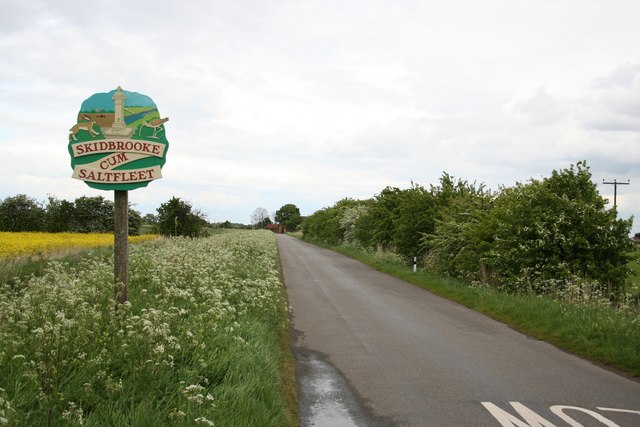
Skidbrooke

Settlement in Lincolnshire East Lindsey

England

Skidbrooke

Saltfleet Manor House As seen, the building is primarily 19th century, but it has origins back to the late 17th, as there is a fine oak staircase of that period, plus a record of the names of two (former residents?) inscribed with a date of 1673 in one of the upstairs rooms. The whole house was Grade II listed <span class="nowrap"><a title="https://historicengland.org.uk/listing/the-list/list-entry/1063062" rel="nofollow ugc noopener" href="https://historicengland.org.uk/listing/the-list/list-entry/1063062">Link</a><img style="margin-left:2px;" alt="External link" title="External link - shift click to open in new window" src="https://s1.geograph.org.uk/img/external.png" width="10" height="10"/></span> & <span class="nowrap"><a title="https://britishlistedbuildings.co.uk/101063062-the-manor-house-skidbrooke-with-saltfleet-haven" rel="nofollow ugc noopener" href="https://britishlistedbuildings.co.uk/101063062-the-manor-house-skidbrooke-with-saltfleet-haven">Link</a><img style="margin-left:2px;" alt="External link" title="External link - shift click to open in new window" src="https://s1.geograph.org.uk/img/external.png" width="10" height="10"/></span> in 1952.
Saltfleet Manor House Credit: Richard Law

Skidbrooke is a small village located in the East Lindsey district of Lincolnshire, England. It is situated approximately 6 miles northeast of the town of Louth and lies close to the coastline of the North Sea. With a population of around 200 residents, Skidbrooke is known for its quiet and rural character.

The village is surrounded by picturesque countryside and farmland, offering stunning views of the Lincolnshire Wolds, an Area of Outstanding Natural Beauty. The area attracts nature enthusiasts and hikers who enjoy exploring the numerous walking trails and observing the diverse wildlife.

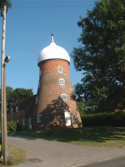
Skidbrooke is home to St. Botolph's Church, a medieval grade II listed building that dates back to the 12th century. The church is renowned for its architectural beauty, with its tower being a prominent landmark in the village. It serves as a place of worship and also holds occasional community events.

Despite its small size, Skidbrooke benefits from its proximity to nearby towns and cities. Louth, the nearest town, offers a range of amenities including shops, schools, and leisure facilities. The village is well-connected by road, with the A16 passing nearby, providing easy access to the wider region.

Skidbrooke offers a peaceful and idyllic lifestyle, with its charming countryside surroundings and close-knit community. Its location also allows residents to enjoy the best of both worlds, with the tranquility of rural living combined with the conveniences of nearby urban areas.

If you have any feedback on the listing, please let us know in the comments section below.

Skidbrooke Images

Images are sourced within 2km of 53.410761/0.163338 or Grid Reference TF4392. Thanks to Geograph Open Source API. All images are credited.

Saltfleet Manor House As seen, the building is primarily 19th century, but it has origins back to the late 17th, as there is a fine oak staircase of that period, plus a record of the names of two (former residents?) inscribed with a date of 1673 in one of the upstairs rooms. The whole house was Grade II listed <span class="nowrap"><a title="https://historicengland.org.uk/listing/the-list/list-entry/1063062" rel="nofollow ugc noopener" href="https://historicengland.org.uk/listing/the-list/list-entry/1063062">Link</a><img style="margin-left:2px;" alt="External link" title="External link - shift click to open in new window" src="https://s1.geograph.org.uk/img/external.png" width="10" height="10"/></span> & <span class="nowrap"><a title="https://britishlistedbuildings.co.uk/101063062-the-manor-house-skidbrooke-with-saltfleet-haven" rel="nofollow ugc noopener" href="https://britishlistedbuildings.co.uk/101063062-the-manor-house-skidbrooke-with-saltfleet-haven">Link</a><img style="margin-left:2px;" alt="External link" title="External link - shift click to open in new window" src="https://s1.geograph.org.uk/img/external.png" width="10" height="10"/></span> in 1952.
Saltfleet Manor House
As seen, the building is primarily 19th century, but it has origins back to the late 17th, as there is a fine oak staircase of that period, plus a record of the names of two (former residents?) inscribed with a date of 1673 in one of the upstairs rooms. The whole house was Grade II listed LinkExternal link & LinkExternal link in 1952.
Saltfleet Methodist Chapel Dated mainly to 1815, although the porch seen here was added in 1867. It was Grade II listed <span class="nowrap"><a title="https://historicengland.org.uk/listing/the-list/list-entry/1165896" rel="nofollow ugc noopener" href="https://historicengland.org.uk/listing/the-list/list-entry/1165896">Link</a><img style="margin-left:2px;" alt="External link" title="External link - shift click to open in new window" src="https://s1.geograph.org.uk/img/external.png" width="10" height="10"/></span> & <span class="nowrap"><a title="https://britishlistedbuildings.co.uk/101165896-methodist-chapel-skidbrooke-with-saltfleet-haven" rel="nofollow ugc noopener" href="https://britishlistedbuildings.co.uk/101165896-methodist-chapel-skidbrooke-with-saltfleet-haven">Link</a><img style="margin-left:2px;" alt="External link" title="External link - shift click to open in new window" src="https://s1.geograph.org.uk/img/external.png" width="10" height="10"/></span> in 1986.
Saltfleet Methodist Chapel
Dated mainly to 1815, although the porch seen here was added in 1867. It was Grade II listed LinkExternal link & LinkExternal link in 1986.
The New Inn at Saltfleet Despite the name, the New Inn dates from the mid 17th century, albeit with extensive alterations and updates over the intervening years. The oldest part is the tall, gabled section visible above the tree on the right and is L-shaped - also the roof of the rest of that older part is visible above the newer, main part of the pub, which was inserted into the angle in the mid 18th century. The whole structure attracted a Grade II listing <span class="nowrap"><a title="https://britishlistedbuildings.co.uk/101359992-the-new-inn-skidbrooke-with-saltfleet-haven" rel="nofollow ugc noopener" href="https://britishlistedbuildings.co.uk/101359992-the-new-inn-skidbrooke-with-saltfleet-haven">Link</a><img style="margin-left:2px;" alt="External link" title="External link - shift click to open in new window" src="https://s1.geograph.org.uk/img/external.png" width="10" height="10"/></span> & <span class="nowrap"><a title="https://historicengland.org.uk/listing/the-list/list-entry/1359992" rel="nofollow ugc noopener" href="https://historicengland.org.uk/listing/the-list/list-entry/1359992">Link</a><img style="margin-left:2px;" alt="External link" title="External link - shift click to open in new window" src="https://s1.geograph.org.uk/img/external.png" width="10" height="10"/></span> in 1967.
The New Inn at Saltfleet
Despite the name, the New Inn dates from the mid 17th century, albeit with extensive alterations and updates over the intervening years. The oldest part is the tall, gabled section visible above the tree on the right and is L-shaped - also the roof of the rest of that older part is visible above the newer, main part of the pub, which was inserted into the angle in the mid 18th century. The whole structure attracted a Grade II listing LinkExternal link & LinkExternal link in 1967.
Saltfleet village water pump A freshwater pump, made of limestone ashlar, and erected in 1899 to the memory of a local man who had recently been killed in conflict in South Africa. It was Grade II listed <span class="nowrap"><a title="https://historicengland.org.uk/listing/the-list/list-entry/1165914" rel="nofollow ugc noopener" href="https://historicengland.org.uk/listing/the-list/list-entry/1165914">Link</a><img style="margin-left:2px;" alt="External link" title="External link - shift click to open in new window" src="https://s1.geograph.org.uk/img/external.png" width="10" height="10"/></span> & <span class="nowrap"><a title="https://britishlistedbuildings.co.uk/101165914-pump-skidbrooke-with-saltfleet-haven" rel="nofollow ugc noopener" href="https://britishlistedbuildings.co.uk/101165914-pump-skidbrooke-with-saltfleet-haven">Link</a><img style="margin-left:2px;" alt="External link" title="External link - shift click to open in new window" src="https://s1.geograph.org.uk/img/external.png" width="10" height="10"/></span> in 1986.
Saltfleet village water pump
A freshwater pump, made of limestone ashlar, and erected in 1899 to the memory of a local man who had recently been killed in conflict in South Africa. It was Grade II listed LinkExternal link & LinkExternal link in 1986.
Sea Bank House, Saltfleet The heart of this (well-hidden) building is a 17th century farmhouse, which has had alterations and extensions over the years - it was originally a single-storey cottage, and one of the first alterations in the mid 18th century was to add an upper floor. It was Grade II listed <span class="nowrap"><a title="https://historicengland.org.uk/listing/the-list/list-entry/1063061" rel="nofollow ugc noopener" href="https://historicengland.org.uk/listing/the-list/list-entry/1063061">Link</a><img style="margin-left:2px;" alt="External link" title="External link - shift click to open in new window" src="https://s1.geograph.org.uk/img/external.png" width="10" height="10"/></span> & <span class="nowrap"><a title="https://britishlistedbuildings.co.uk/101063061-seabank-house-skidbrooke-with-saltfleet-haven" rel="nofollow ugc noopener" href="https://britishlistedbuildings.co.uk/101063061-seabank-house-skidbrooke-with-saltfleet-haven">Link</a><img style="margin-left:2px;" alt="External link" title="External link - shift click to open in new window" src="https://s1.geograph.org.uk/img/external.png" width="10" height="10"/></span> in 1983.
Sea Bank House, Saltfleet
The heart of this (well-hidden) building is a 17th century farmhouse, which has had alterations and extensions over the years - it was originally a single-storey cottage, and one of the first alterations in the mid 18th century was to add an upper floor. It was Grade II listed LinkExternal link & LinkExternal link in 1983.
Saltfleet Windmill ('The Mill') An early 19th century tower mill of brown & red brick, formerly producing flour from local wheat. In 1986 when it was Grade II listed <span class="nowrap"><a title="https://britishlistedbuildings.co.uk/101165939-windmill-skidbrooke-with-saltfleet-haven" rel="nofollow ugc noopener" href="https://britishlistedbuildings.co.uk/101165939-windmill-skidbrooke-with-saltfleet-haven">Link</a><img style="margin-left:2px;" alt="External link" title="External link - shift click to open in new window" src="https://s1.geograph.org.uk/img/external.png" width="10" height="10"/></span> & <span class="nowrap"><a title="https://historicengland.org.uk/listing/the-list/list-entry/1165939," rel="nofollow ugc noopener" href="https://historicengland.org.uk/listing/the-list/list-entry/1165939,">Link</a><img style="margin-left:2px;" alt="External link" title="External link - shift click to open in new window" src="https://s1.geograph.org.uk/img/external.png" width="10" height="10"/></span> the interior floors were described as being 'in a state of collapse' but that has presumably been rectified during its conversion to residential use. The domed cap is likely to have been restored at that stage too.
Saltfleet Windmill ('The Mill')
An early 19th century tower mill of brown & red brick, formerly producing flour from local wheat. In 1986 when it was Grade II listed LinkExternal link & LinkExternal link the interior floors were described as being 'in a state of collapse' but that has presumably been rectified during its conversion to residential use. The domed cap is likely to have been restored at that stage too.
Saltfleet: brick shed on a corner by Grayfleet Bank
Paradise: Public Bridleway past the newly fortified Great Eau Bridge, through Paradise, to the sea shore The sign says Public Footpath, but it is marked on the map as a Bridleway.
Paradise: Public Bridleway past the newly fortified Great Eau Bridge, through Paradise, to the sea shore
The sign says Public Footpath, but it is marked on the map as a Bridleway.
Shoot-out in Paradise (Saltfleet) Not the only local sign to have been used for target practice!
Shoot-out in Paradise (Saltfleet)
Not the only local sign to have been used for target practice!
Paradise: gate and opening on Public Bridleway from Paradise, to the sea shore Path is marked on map as a Bridleway, though the sign at the end says it is a Footpath.
Paradise: gate and opening on Public Bridleway from Paradise, to the sea shore
Path is marked on map as a Bridleway, though the sign at the end says it is a Footpath.
Paradise: Sign on gate across the Bridleway through Paradise to the sea shore
Wingas Gas Storage Depot, Howdales: aerial 2016 For update and history see [[<a href="https://www.geograph.org.uk/photo/7353267">TF4291 : Saltfleetby gas field, Howdales: aerial 2022</a> and <span class="nowrap"><a title="https://www.angusenergy.co.uk/what-we-do/saltfleetby-gas-field/" rel="nofollow ugc noopener" href="https://www.angusenergy.co.uk/what-we-do/saltfleetby-gas-field/">Link</a><img style="margin-left:2px;" alt="External link" title="External link - shift click to open in new window" src="https://s1.geograph.org.uk/img/external.png" width="10" height="10"/></span>
Wingas Gas Storage Depot, Howdales: aerial 2016
Saltfleet Playing Field: aerial 2015
Across Skidbrooke to Saltfleet: aerial 2016
Crossing the coast at Saltfleet The caravan park visible on the ground is the "Sunnydale" park at Saltfleet.

Taken with an iPad camera through the window of flight KL1490 on a Sunday morning
Crossing the coast at Saltfleet
The caravan park visible on the ground is the "Sunnydale" park at Saltfleet. Taken with an iPad camera through the window of flight KL1490 on a Sunday morning
Skidbrooke, St. Botolph's Church
Skidbrooke, St. Botolph's Church: The nave
Skidbrooke, St. Botolph's Church: Capital
Show me another place!

Skidbrooke is located at Grid Ref: TF4392 (Lat: 53.410761, Lng: 0.163338)

Division: Parts of Lindsey

Administrative County: Lincolnshire

District: East Lindsey

Police Authority: Lincolnshire

What 3 Words

///shippers.campsites.splint. Near North Somercotes, Lincolnshire

Nearby Locations

Skidbrooke

Related Wikis

Skidbrooke

Skidbrooke, also called Skidbrooke cum Saltfleet, is a hamlet in the East Lindsey district of Lincolnshire, England. It is situated 10 miles (16 km) north...

St Botolph's Church, Skidbrooke

St Botolph's Church is a redundant Anglican church near the village of Skidbrooke, Lincolnshire, England. It is recorded in the National Heritage List...

Lincolnshire Marsh

The Lincolnshire Marsh is a belt of reclaimed salt marsh and sand dune in Lincolnshire, England, between the Lincolnshire Wolds and the North Sea coast...

Saltfleet

Saltfleet is a coastal village in the East Lindsey district of Lincolnshire, England. It is approximately 8 miles (13 km) north of Mablethorpe and 11...

Nearby Amenities

Located within 500m of 53.410761,0.163338
Skidbrooke
Is In: Lincolnshire, England, UK
Place: hamlet
Source: OS_OpenData_StreetView
Wikidata: Q7535050
Lat/Long: 53.4089686/0.1626068
Bus Stop
Saddleback Road
Naptan AtcoCode: 270000009942
Naptan Bearing: SE
Naptan CommonName: Saddleback Road
Naptan Indicator: opp
Naptan Landmark: Saddleback Road
Naptan NaptanCode: linjgjpj
Naptan Street: North Road
Naptan Verified: no
Source: naptan_import
Lat/Long: 53.4108744/0.1636732
Bus Stop
Saddleback Road
Naptan AtcoCode: 270000009943
Naptan Bearing: NW
Naptan CommonName: Saddleback Road
Naptan Indicator: adj
Naptan Landmark: Saddleback Road
Naptan NaptanCode: linjgjpm
Naptan Street: North Road
Naptan Verified: no
Source: naptan_import
Lat/Long: 53.410879/0.1634176
Bus Stop
Pear Tree House
Naptan AtcoCode: 270000009945
Naptan Bearing: NW
Naptan CommonName: Pear Tree House
Naptan Indicator: NW - bound
Naptan Landmark: Pear Tree House
Naptan NaptanCode: linjgjpw
Naptan Street: West Lane
Naptan Verified: no
Source: naptan_import
Lat/Long: 53.4086648/0.1680147
Bus Stop
Pear Tree House
Naptan AtcoCode: 2700LSC06351
Naptan Bearing: SE
Naptan CommonName: Pear Tree House
Naptan Indicator: SE - bound
Naptan Landmark: Pear Tree House
Naptan NaptanCode: lingdaja
Naptan Street: West Lane
Naptan Verified: no
Source: naptan_import
Lat/Long: 53.4087609/0.1681701
Laburnum Farm
Place: farm
Source: Bing
Lat/Long: 53.4075757/0.167273
The Grange
Place: farm
Source: Bing
Lat/Long: 53.4103046/0.1620511
White House Farm
Place: farm
Source: Bing
Lat/Long: 53.4108649/0.1703801
Willow Farm
Place: farm
Source: Bing
Lat/Long: 53.4069324/0.1658805
The Old Rectory
Place: isolated_dwelling
Source: Bing
Lat/Long: 53.4128112/0.1624149
Weldon House
Place: isolated_dwelling
Source: Bing
Lat/Long: 53.4107419/0.1645921
Kala Croft
Place: isolated_dwelling
Lat/Long: 53.4098648/0.1697298
Pear Tree House
Place: isolated_dwelling
Lat/Long: 53.408564/0.1685471
The data included in this document is from www.openstreetmap.org. The data is made available under ODbL.

Have you been to Skidbrooke?

Leave your review of Skidbrooke below (or comments, questions and feedback).