Shay Gate

Settlement in Yorkshire

England

Shay Gate

Norr, Norr Farm The benchmark is cut into a stone surround of a redundant doorway in the back of the farm building. The building runs alongside the footpath.
Norr, Norr Farm Credit: Mel Towler

Shay Gate is a small village located in the county of Yorkshire, England. Situated in the picturesque countryside, it is known for its charming and idyllic surroundings, making it a popular destination for nature lovers and those seeking a peaceful retreat.

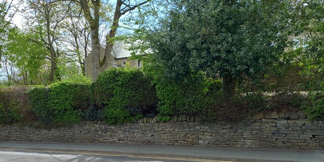
The village is characterized by its traditional stone cottages and well-maintained gardens, which add to its quaint and rustic charm. The local community takes pride in preserving the historical architecture and heritage of the area, creating an authentic and welcoming atmosphere for visitors.

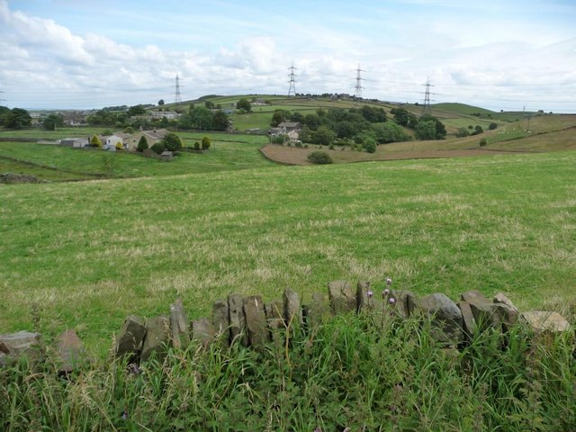
Shay Gate is surrounded by stunning natural landscapes, with rolling hills and expansive fields providing the perfect backdrop for outdoor activities such as hiking and cycling. The nearby Shay River offers opportunities for fishing and boating, adding to the recreational options available to residents and tourists alike.

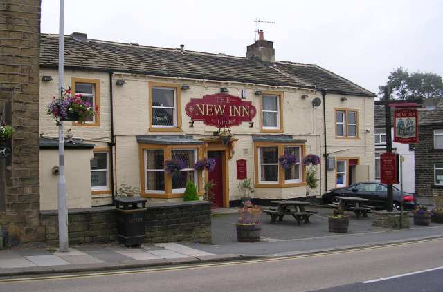
Despite its small size, Shay Gate boasts a range of amenities to cater to the needs of its residents. These include a village hall, a pub serving traditional Yorkshire dishes, and a local convenience store for everyday essentials. The village also hosts various community events throughout the year, fostering a strong sense of community spirit.

With its tranquil setting and friendly atmosphere, Shay Gate offers a peaceful escape from the hustle and bustle of city life. Whether it's exploring the scenic countryside, immersing oneself in the local culture, or simply enjoying the serenity of the surroundings, this charming Yorkshire village has something to offer everyone.

If you have any feedback on the listing, please let us know in the comments section below.

Shay Gate Images

Images are sourced within 2km of 53.811194/-1.8496162 or Grid Reference SE1035. Thanks to Geograph Open Source API. All images are credited.

Norr, Norr Farm The benchmark is cut into a stone surround of a redundant doorway in the back of the farm building. The building runs alongside the footpath.
Norr, Norr Farm
The benchmark is cut into a stone surround of a redundant doorway in the back of the farm building. The building runs alongside the footpath.
Norr, Norr Farm There is a benchmark cut into a stone surround of a redundant doorway in the back of the farm building. It is close to the crated container.
Norr, Norr Farm
There is a benchmark cut into a stone surround of a redundant doorway in the back of the farm building. It is close to the crated container.
Wilsden, wall on Crack Lane According to the OS benchmark database there was a benchmark cut into the roadside wall along this stretch of wall. There has recently been new housing and a new wall and it is likely the benchmark has been destroyed.
Wilsden, wall on Crack Lane
According to the OS benchmark database there was a benchmark cut into the roadside wall along this stretch of wall. There has recently been new housing and a new wall and it is likely the benchmark has been destroyed.
Wilsden, New Inn PH The benchmark, which has been overpainted with black and white masonry paint, is on the front face of the pub.
Wilsden, New Inn PH
The benchmark, which has been overpainted with black and white masonry paint, is on the front face of the pub.
Wilsden, New Inn PH There is a benchmark, which has been overpainted with black and white masonry paint, on the front face of the pub. It is behind the red car.
Wilsden, New Inn PH
There is a benchmark, which has been overpainted with black and white masonry paint, on the front face of the pub. It is behind the red car.
Wilsden, Main Street According to the OS benchmark database there was a benchmark cut into a stone on this stretch of roadside wall. Nothing was found. The height above ground level is  10cm, and with subsequent new pavement tarmac it is likely that this mark has been destroyed.
Wilsden, Main Street
According to the OS benchmark database there was a benchmark cut into a stone on this stretch of roadside wall. Nothing was found. The height above ground level is 10cm, and with subsequent new pavement tarmac it is likely that this mark has been destroyed.
Wilsden, Prospect Mills The OS Flush Bracket S0897 is embedded into the north-east face of the previous Prospect Mills, and remains in good condition.
Wilsden, Prospect Mills
The OS Flush Bracket S0897 is embedded into the north-east face of the previous Prospect Mills, and remains in good condition.
Crane at construction site A battery storage facility is under construction close to a large electricity sub-station. This is the view from Old Allen Road near Little Moor Top Farm.
Crane at construction site
A battery storage facility is under construction close to a large electricity sub-station. This is the view from Old Allen Road near Little Moor Top Farm.
Electricity Sub-station Isolated in the middle of farmland, viewed from Old Allen Road.
Electricity Sub-station
Isolated in the middle of farmland, viewed from Old Allen Road.
Electricity Sub-station With a crane at a battery storage facility undergoing construction
Electricity Sub-station
With a crane at a battery storage facility undergoing construction
Allen Park Farm, Thornton Seen from Ten Yards Lane.
Allen Park Farm, Thornton
Seen from Ten Yards Lane.
Tewitt House, Tewitt Lane Possibly unoccupied.
Tewitt House, Tewitt Lane
Possibly unoccupied.
Drystone wall field boundary, south of Tewitt Lane. Low wall, tall thistles!
Drystone wall field boundary, south of Tewitt Lane.
Low wall, tall thistles!
Cyclist heading west on Tewitt Lane A member of the Otley Cycling Club, according to his top.
Cyclist heading west on Tewitt Lane
A member of the Otley Cycling Club, according to his top.
Horses grazing, north of tewitt Lane They weren't particularly inquisitive.
Horses grazing, north of tewitt Lane
They weren't particularly inquisitive.
Black Dyke Lane Passing Hazel Crook End Farm.
Black Dyke Lane
Passing Hazel Crook End Farm.
Manor Farm Seen across a small valley from Black Dyke Lane.
Manor Farm
Seen across a small valley from Black Dyke Lane.
Show me another place!

Shay Gate is located at Grid Ref: SE1035 (Lat: 53.811194, Lng: -1.8496162)

Division: West Riding

Unitary Authority: Bradford

Police Authority: West Yorkshire

What 3 Words

///twice.cave.steer. Near Wilsden, West Yorkshire

Related Wikis

Sandy Lane, West Yorkshire

Sandy Lane is a village and civil parish to the north of Bradford, West Yorkshire, England. The population of the civil parish as of the 2011 census was...

Bingley Rural

Bingley Rural is an electoral ward in the City of Bradford Metropolitan District Council. The population of the ward at the 2011 Census was 17,895.It encompasses...

Wilsden

Wilsden is a village and civil parish in west Bradford, in West Yorkshire, England. Wilsden is 6 miles (9.7 km) west of Bradford and is close to the Aire...

Egypt, Bradford

Egypt is a hamlet near Thornton, in the City of Bradford, West Yorkshire, England. == Geography == Egypt is situated about one mile (1.6 km) north-west...

Have you been to Shay Gate?

Leave your review of Shay Gate below (or comments, questions and feedback).