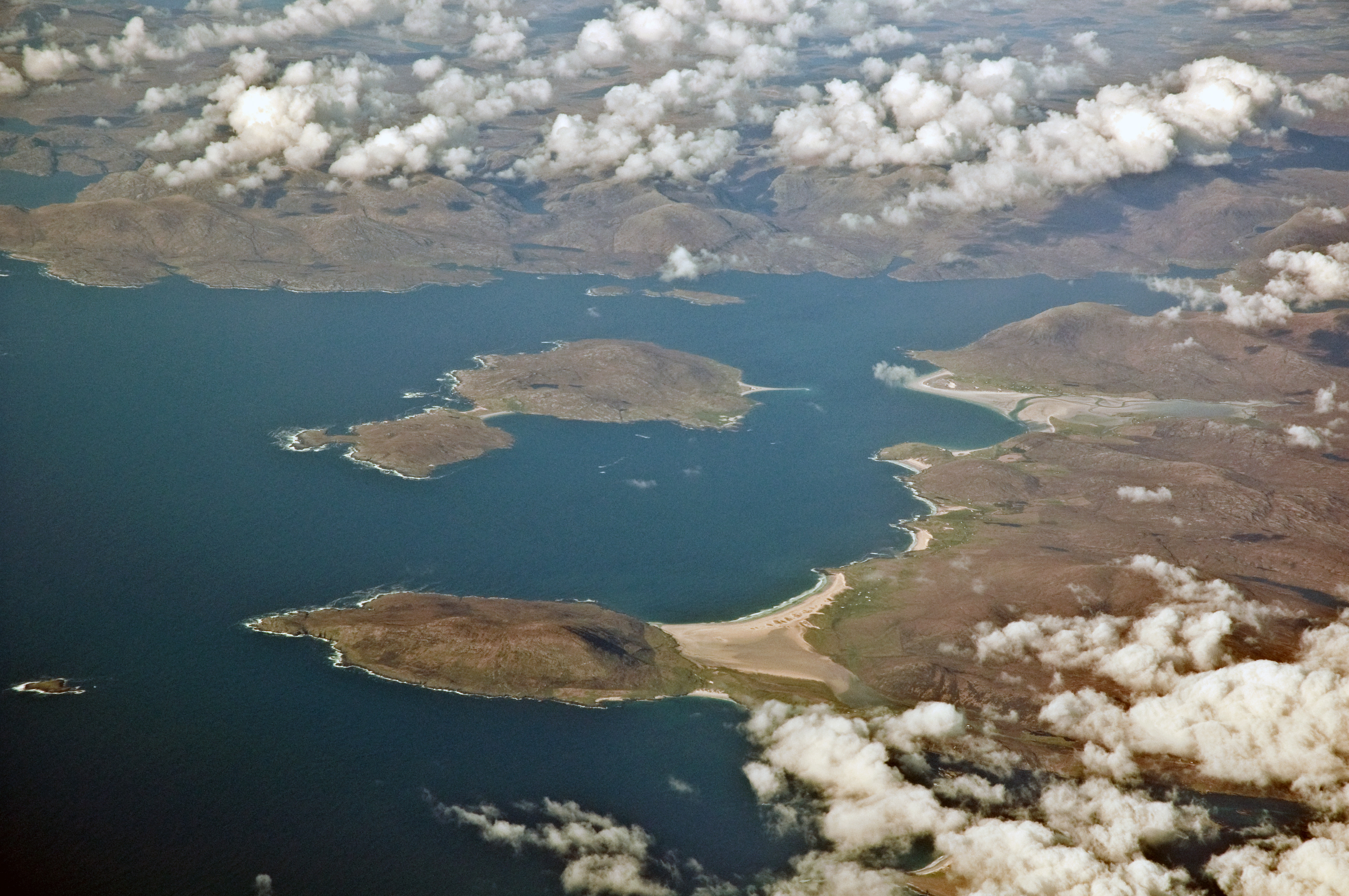
Seilebost

Settlement in Inverness-shire

Scotland

Seilebost

View to Luskentyre From a viewpoint on the A859.
View to Luskentyre Credit: Richard Dorrell

Seilebost is a small village located in the Inverness-shire region of Scotland. Situated on the west coast of the Isle of Harris, it is part of the Outer Hebrides archipelago. The village is surrounded by stunning natural beauty, with golden sandy beaches and clear blue waters offering breathtaking views.

Seilebost is a remote and peaceful community, with a population of around 100 residents. The village consists mainly of traditional white-washed cottages, adding to its charm and character. The locals are known for their warm hospitality and strong ties to their Gaelic heritage.

One of the main attractions of Seilebost is its beach, which stretches for miles and is often described as one of the most beautiful in Scotland. The crystal-clear water and white sands make it a perfect spot for relaxing walks or picnics. The area is also popular among surfers, thanks to the consistent waves and natural beauty.

Aside from its natural wonders, Seilebost is also known for its rich history. Nearby, visitors can explore ancient ruins and archaeological sites, including standing stones and burial mounds, which provide insight into the area's past.

Although Seilebost is a small village, it offers a range of amenities for visitors. There are a few guesthouses and self-catering accommodations available, as well as a local shop and café where visitors can stock up on supplies or enjoy a meal.

Overall, Seilebost is a hidden gem nestled on the Isle of Harris, offering visitors a chance to experience the tranquility of Scottish island life and immerse themselves in the breathtaking natural beauty of the area.

If you have any feedback on the listing, please let us know in the comments section below.

Seilebost Images

Images are sourced within 2km of 57.866821/-6.9554403 or Grid Reference NG0697. Thanks to Geograph Open Source API. All images are credited.

View to Luskentyre From a viewpoint on the A859.
View to Luskentyre
From a viewpoint on the A859.
Toward North Harris Looking north from close to the standing stone, Clach Mhic Leòid.
Toward North Harris
Looking north from close to the standing stone, Clach Mhic Leòid.
Traigh Sheileboist in 1981
Bungalow and field near Tràigh Nisaboist
Spring on the beach at Tràigh Nisaboist A micro-sized hydrological model.
Spring on the beach at Tràigh Nisaboist
A micro-sized hydrological model.
Tràigh Losgaintir at low tide
Double Rainbow at Seilebost
Footprints in the sand at Corran Sheileboist
Scenic parking spot
Scenic parking spot
Abhainn Sheileaboist
Traigh Sheileboist On a perfect day of azure seas and silver sands, Hebridean beaches are unsurpassed!  Traigh Losgaintir (Luskentyre) in the distance.

The blues are true - no Photoshopping here!
Traigh Sheileboist
On a perfect day of azure seas and silver sands, Hebridean beaches are unsurpassed! Traigh Losgaintir (Luskentyre) in the distance. The blues are true - no Photoshopping here!
Primroses above Traigh Sheileboist On a perfect day of azure seas and silver sands, Hebridean beaches are unsurpassed!  Traigh Losgaintir (Luskentyre) in the distance.

The blues are true - no Photoshopping here!
Primroses above Traigh Sheileboist
On a perfect day of azure seas and silver sands, Hebridean beaches are unsurpassed! Traigh Losgaintir (Luskentyre) in the distance. The blues are true - no Photoshopping here!
Traigh Sheileboist On a perfect day of azure seas and silver sands, Hebridean beaches are unsurpassed!  This one is busy - I can count six people on it!  Traigh Losgaintir (Luskentyre) in the distance.

The blues are true - no Photoshopping here!
Traigh Sheileboist
On a perfect day of azure seas and silver sands, Hebridean beaches are unsurpassed! This one is busy - I can count six people on it! Traigh Losgaintir (Luskentyre) in the distance. The blues are true - no Photoshopping here!
Tràigh Losgaintir and Taransay Looking west to the island of Taransay, beyond the dunes of Luskentyre.
Tràigh Losgaintir and Taransay
Looking west to the island of Taransay, beyond the dunes of Luskentyre.
The A859 at Seilebost A lay-by at a fine viewpoint for Luskentyre and Tràigh Sheileboist.
The A859 at Seilebost
A lay-by at a fine viewpoint for Luskentyre and Tràigh Sheileboist.
Tràigh Sheileboist Seen from Seilebost, with Luskentyre beyond
Tràigh Sheileboist
Seen from Seilebost, with Luskentyre beyond
Tràigh Losgaintir Looking west, across the estuary of Losgaintir, with the isle of Taransay/Tarasaigh in the distance.
Tràigh Losgaintir
Looking west, across the estuary of Losgaintir, with the isle of Taransay/Tarasaigh in the distance.
Tràigh Losgaintir Looking out over the estuary. A wide estuary, but not created by any large rivers - the catchment from An Coileach  and four other small peaks is fairly small.
Tràigh Losgaintir
Looking out over the estuary. A wide estuary, but not created by any large rivers - the catchment from An Coileach and four other small peaks is fairly small.
Show me another place!

Seilebost is located at Grid Ref: NG0697 (Lat: 57.866821, Lng: -6.9554403)

Unitary Authority: Na h-Eileanan an Iar

Police Authority: Highlands and Islands

What 3 Words

///dressings.ridge.between. Near Tarbert, Na h-Eileanan Siar

Related Wikis

Luskentyre

Luskentyre (Scottish Gaelic: Losgaintir) is a sparse settlement on the west coast of Harris, in the Outer Hebrides, Scotland. Luskentyre is situated within...

Borve, Harris

Borve (Scottish Gaelic: Na Buirgh) is a village in Harris in the Outer Hebrides, Scotland. Borve is also within the parish of Harris, and is on the A859...

Taransay

Taransay (Scottish Gaelic: Tarasaigh, pronounced [ˈt̪ʰaɾas̪aj]) is an island in the Outer Hebrides of Scotland. It was the host of the British television...

West Loch Tarbert

West Loch Tarbert (Scottish Gaelic: Loch A Siar) is a sea loch that separates the northern and southern parts of Harris in the Outer Hebrides of Scotland...

Nearby Amenities

Located within 500m of 57.866821,-6.9554403
Created By: dmgroom_coastlines
Lat/Long: 57.86812/-6.96216
Created By: dmgroom_coastlines
Lat/Long: 57.86863/-6.96189
Bus Stop
Seilebost
Naptan AtcoCode: 6010731800
Naptan Bearing: W
Naptan CommonName: Seilebost
Naptan Indicator: Seilebost
Naptan Landmark: Seilebost
Naptan NaptanCode: 94723673
Naptan Street: Seilebost
Naptan Verified: no
Source: naptan_import
Lat/Long: 57.8666816/-6.95543
Seilebost
Place: village
Source: NaPTAIN;OS Open Data StreetView
Lat/Long: 57.8654356/-6.9494431
Generator Method: wind_turbine
Generator Source: wind
Generator Type: horizontal_axis
Power: generator
Lat/Long: 57.8683668/-6.9549179
Turning Circle
Lat/Long: 57.8667907/-6.9597904
Barrier: cattle_grid
Lat/Long: 57.8650283/-6.9530408
Material: wood
Power: pole
Lat/Long: 57.8668972/-6.9610276
Material: wood
Power: pole
Lat/Long: 57.8669671/-6.96246
Material: wood
Power: pole
Lat/Long: 57.8665391/-6.959649
Material: wood
Power: pole
Lat/Long: 57.8663715/-6.9563338
Material: wood
Power: pole
Lat/Long: 57.8659478/-6.9555574
Material: wood
Power: pole
Lat/Long: 57.8660712/-6.9547929
Material: wood
Power: pole
Lat/Long: 57.8668837/-6.9546453
Material: wood
Power: pole
Lat/Long: 57.8668689/-6.9568195
Generator Method: photovoltaic
Generator Output Electricity: small_installation
Generator Source: solar
Generator Type: solar_photovoltaic_panel
Power: generator
Lat/Long: 57.865382/-6.9532895
Material: wood
Power: pole
Lat/Long: 57.8644976/-6.9528898
Material: wood
Power: pole
Lat/Long: 57.864402/-6.9522166
Material: wood
Power: pole
Lat/Long: 57.86481/-6.9524151
Material: wood
Power: pole
Lat/Long: 57.8648628/-6.9535658
Material: wood
Power: pole
Lat/Long: 57.8655854/-6.9548733
Material: wood
Power: pole
Lat/Long: 57.864118/-6.9521474
Passing Place
Lat/Long: 57.8646752/-6.9526859
Material: wood
Power: pole
Lat/Long: 57.8639627/-6.9495889
Passing Place
Lat/Long: 57.8671438/-6.9584101
Barrier: cattle_grid
Lat/Long: 57.8645876/-6.9485212
Power: pole
Lat/Long: 57.8645222/-6.9490124
Power: pole
Lat/Long: 57.8642286/-6.9486325
Power: pole
Lat/Long: 57.8671753/-6.9545516
Power: pole
Lat/Long: 57.8668562/-6.9594863
Power: pole
Lat/Long: 57.8667376/-6.9578081
Power: pole
Lat/Long: 57.8668542/-6.9558912
Barrier: cattle_grid
Lat/Long: 57.8686471/-6.9534429
Power: pole
Lat/Long: 57.8668692/-6.9552354
Barrier: cattle_grid
Lat/Long: 57.8670981/-6.9560508
The data included in this document is from www.openstreetmap.org. The data is made available under ODbL.

Have you been to Seilebost?

Leave your review of Seilebost below (or comments, questions and feedback).