Scothern

Settlement in Lincolnshire West Lindsey

England

Scothern

A new road by the new development at Ashlin Farm As this is off Ashing Lane I suspect a typo by the original OS cartographers maybe?
A new road by the new development at Ashlin Farm Credit: David Brown

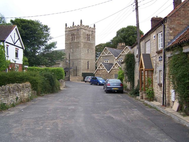
Scothern is a picturesque village located in the county of Lincolnshire in eastern England. Situated approximately 7 miles north of the city of Lincoln, it falls within the West Lindsey district. The village is nestled in a rural setting, surrounded by beautiful countryside and farmland.

Scothern has a rich history dating back to the Roman era, with evidence of Roman settlements in the area. Today, it retains its charm with a mix of traditional architecture and modern developments. The village is primarily residential, with a small number of shops and amenities catering to the local community.

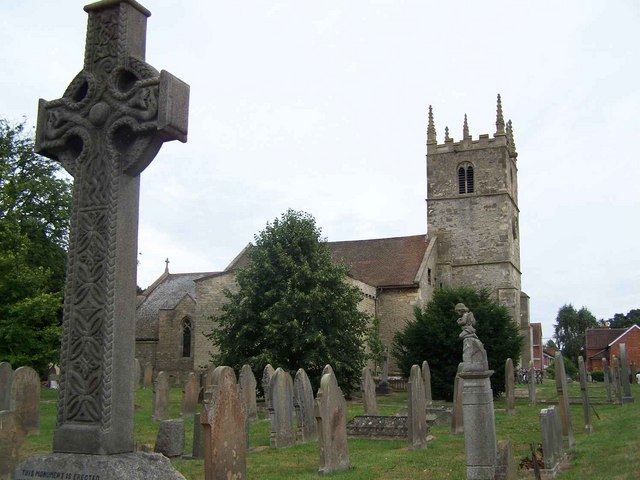
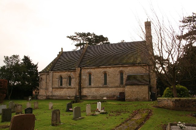
One of the notable landmarks in Scothern is the All Saints Church, a Grade II listed building dating back to the 13th century. It features a beautiful stained glass window and hosts regular worship services.

The village also boasts a strong sense of community with various local organizations and events. The Scothern Show, an annual agricultural event, attracts visitors from near and far. It showcases local produce, farm animals, and traditional crafts, providing a glimpse into the region's rural heritage.

For outdoor enthusiasts, Scothern offers ample opportunities for exploring the surrounding countryside. There are several walking and cycling routes that provide stunning views of the Lincolnshire landscape. Additionally, nearby attractions such as Lincoln Castle and the Lincolnshire Wolds are easily accessible, offering further recreational activities and historical sites to explore.

Overall, Scothern is a charming village that combines history, natural beauty, and community spirit, making it a desirable place to live or visit in Lincolnshire.

If you have any feedback on the listing, please let us know in the comments section below.

Scothern Images

Images are sourced within 2km of 53.283757/-0.449564 or Grid Reference TF0377. Thanks to Geograph Open Source API. All images are credited.

A new road by the new development at Ashlin Farm As this is off Ashing Lane I suspect a typo by the original OS cartographers maybe?
A new road by the new development at Ashlin Farm
As this is off Ashing Lane I suspect a typo by the original OS cartographers maybe?
Entrance to Monks Wood
Path on the south side of the nature reserve
Plantation by Stainton Lane
Looe Farm on Stainton Lane
Methodist Church, Scothern
Track towards Dunholme
Field path near Dunholme
St.Edward's church, Sudbrooke, Lincs. Neo-Norman by Dobson of Newcastle in 1862, paid for by the Ellison family, bankers in Lincoln who lived at Sudbrooke Hall. The Hall is now gone and the parkland developed with housing.
St.Edward's church, Sudbrooke, Lincs.
Neo-Norman by Dobson of Newcastle in 1862, paid for by the Ellison family, bankers in Lincoln who lived at Sudbrooke Hall. The Hall is now gone and the parkland developed with housing.
St.Germain's church, Scothern, Lincs. A pinnacled Perpendicular tower and a church rebuilt in 1796, the medieval tower and chancel arches remain.
St.Germain's church, Scothern, Lincs.
A pinnacled Perpendicular tower and a church rebuilt in 1796, the medieval tower and chancel arches remain.
Heath Road near Dunholme, Lincolnshire This narrow country lane is very busy being a short cut between the A46 and the A158
Heath Road near Dunholme, Lincolnshire
This narrow country lane is very busy being a short cut between the A46 and the A158
Farmland off Heath Lane, near Scothern, Lincolnshire
Countryside near Scothern
Heath Road, Scothern Heath Road joins Dunholme Road
Heath Road, Scothern
Heath Road joins Dunholme Road
Farmland near Scothern, Lincolnshire Looking towards Two Acres Farm, the field margins all round here were festooned with poppies and oil seed rape escapees. The poppies' colour is so intense that it fairly jumps off the page!
Farmland near Scothern, Lincolnshire
Looking towards Two Acres Farm, the field margins all round here were festooned with poppies and oil seed rape escapees. The poppies' colour is so intense that it fairly jumps off the page!
Farmland near Scothern, Lincolnshire This overgrown drainage ditch is sporting a fine crop of last season's bull rush seed heads. See <span class="nowrap"><a title="http://www.arkive.org/species/ARK/plants_and_algae/Typha_latifolia/" rel="nofollow ugc noopener" href="http://www.arkive.org/species/ARK/plants_and_algae/Typha_latifolia/">Link</a><img style="margin-left:2px;" alt="External link" title="External link - shift click to open in new window" src="https://s1.geograph.org.uk/img/external.png" width="10" height="10"/></span>
Farmland near Scothern, Lincolnshire
This overgrown drainage ditch is sporting a fine crop of last season's bull rush seed heads. See LinkExternal link
The end of the road. Northing Lane at Scothern comes to a halt in a field. The old 1940s map shows a building called Pyewipe here but all that remains is a rubble filled mound of earth.
The end of the road.
Northing Lane at Scothern comes to a halt in a field. The old 1940s map shows a building called Pyewipe here but all that remains is a rubble filled mound of earth.
Public Footpath near Scothern, Lincolnshire The footpath cuts across fields on its way to Mickleholme after it leaves Northing Lane.
Public Footpath near Scothern, Lincolnshire
The footpath cuts across fields on its way to Mickleholme after it leaves Northing Lane.
Show me another place!

Scothern is located at Grid Ref: TF0377 (Lat: 53.283757, Lng: -0.449564)

Division: Parts of Lindsey

Administrative County: Lincolnshire

District: West Lindsey

Police Authority: Lincolnshire

What 3 Words

///foil.lizards.pedicure. Near Sudbrooke, Lincolnshire

Nearby Locations

Scothern Scothern

Related Wikis

Scothern

Scothern is a small village and civil parish in the West Lindsey district of Lincolnshire, England. It is situated 6 miles (10 km) north-east of the county...

Ellison Boulters Academy

Ellison Boulters Church of England Primary Academy is situated in Scothern, Lincolnshire, England, on Sudbrooke Road. It has around 270 pupils, and accepts...

Holme, West Lindsey

Holme is the site of a lost settlement in West Lindsey, Lincolnshire, England. It is situated approximately 4 miles (6 km) north-east from the city of...

Sudbrooke

Sudbrooke is a small village and Civil Parish in the West Lindsey district of Lincolnshire, England. It is situated 4.5 miles (7 km) north-east from the...

Dunholme

Dunholme is a village and civil parish in the West Lindsey district of Lincolnshire, England. It is situated on the A46 road, and 5 miles (8 km) north...

Langworth railway station

Langworth railway station was a railway station in Langworth, Lincolnshire, opened in 1848 and closed in 1965. On 30 June 2015, a freight train was derailed...

Welton Beck

Welton Beck is a small local stream which originates from Old Man's Head Spring in the west of Welton civil parish and flows eastwards through Welton and...

Welton, Lincolnshire

Welton (; or Welton by Lincoln) is a large village and civil parish in the West Lindsey district of Lincolnshire, England. The population of the civil...

Nearby Amenities

Located within 500m of 53.283757,-0.449564
Scothern
Is In: Lincolnshire, England, UK
Place: village
Source: NPE
Lat/Long: 53.2841467/-0.4488097
Bus Stop
Cade Close
Naptan AtcoCode: 270000007863
Naptan Bearing: SW
Naptan CommonName: Cade Close
Naptan Indicator: adj
Naptan Landmark: Cade Close
Naptan NaptanCode: lingmgdm
Naptan Street: Nettleham Road
Naptan Verified: no
Source: naptan_import
Lat/Long: 53.281818/-0.4552056
Bus Stop
Cade Close
Naptan AtcoCode: 270000007864
Naptan Bearing: NE
Naptan CommonName: Cade Close
Naptan Indicator: opp
Naptan Landmark: Cade Close
Naptan NaptanCode: lingmgdp
Naptan Street: Nettleham Road
Naptan Verified: no
Source: naptan_import
Lat/Long: 53.2818287/-0.4553402
Bus Stop
Mill Rise
Naptan AtcoCode: 270000007865
Naptan Bearing: SW
Naptan CommonName: Mill Rise
Naptan Indicator: adj
Naptan Landmark: Mill Rise
Naptan NaptanCode: lingmgdt
Naptan Street: Sudbrooke Road
Naptan Verified: no
Source: naptan_import
Lat/Long: 53.282309/-0.4493977
Bus Stop
Scothern Nursery
Naptan AtcoCode: 270000007868
Naptan Bearing: NW
Naptan CommonName: Scothern Nursery
Naptan Indicator: adj
Naptan Landmark: Scothern Nursery
Naptan NaptanCode: lingmgjd
Naptan Street: Dunholme Road
Naptan Verified: no
Source: naptan_import
Lat/Long: 53.2846376/-0.456349
Bus Stop
Bottle & Glass PH
Naptan AtcoCode: 270002700929
Naptan Bearing: NW
Naptan CommonName: Bottle & Glass PH
Naptan Indicator: o/s
Naptan Landmark: Bottle & Glass PH
Naptan Street: Sudbrooke Road
Naptan Verified: no
Source: naptan_import
Lat/Long: 53.2841041/-0.4498728
Meadow Close
Naptan AtcoCode: 2700LSBG6714
Naptan Bearing: W
Naptan BusStopType: CUS
Naptan CommonName: Meadow Close
Naptan Indicator: adj
Naptan Landmark: Meadow Close
Naptan NaptanCode: lingdwgt
Naptan Street: Main Street
Naptan Verified: no
Source: naptan_import
Lat/Long: 53.2845138/-0.4454326
Bus Stop
St German's Church
Naptan AtcoCode: 2700LSC01489
Naptan CommonName: St German's Church
Naptan Indicator: adj
Naptan Landmark: St German's Church
Naptan NaptanCode: linajwta
Naptan Street: Church Street
Naptan Verified: no
Public Transport: platform
Lat/Long: 53.2839091/-0.4516606
Bus Stop
St German's Church
Naptan AtcoCode: 2700LSCSC766
Naptan Bearing: N
Naptan CommonName: St German's Church
Naptan Indicator: opp
Naptan Landmark: St German's Church
Naptan NaptanCode: linagjgm
Naptan Street: Church Street
Naptan Verified: no
Source: naptan_import
Lat/Long: 53.2839044/-0.4518001
Bus Stop
Mill Rise
Naptan AtcoCode: 2700LSPS6167
Naptan Bearing: NE
Naptan CommonName: Mill Rise
Naptan Indicator: opp
Naptan Landmark: Mill Rise
Naptan NaptanCode: lingapdw
Naptan Street: Sudbrooke Road
Naptan Verified: no
Source: naptan_import
Lat/Long: 53.2823381/-0.4495617
Pub
Bottle & Glass
Addr City: Lincoln
Addr Country: GB
Addr Housenumber: 14
Addr Place: Scothern
Addr Postcode: LN2 2UG
Addr Street: Main Street
Lat/Long: 53.284148/-0.4500736
FIXME: location unclear
Lat/Long: 53.2843279/-0.4518578
Community Centre
LiteHouse Community Centre
Lat/Long: 53.2842604/-0.4555988
Post Box
Ref: LN2 563
Source: survey
Lat/Long: 53.2825153/-0.4549493
Turning Circle
Lat/Long: 53.2822867/-0.4474422
Crossing
Lat/Long: 53.2817073/-0.4553409
Manor Farm
Place: farm
Source: Bing
Lat/Long: 53.2854023/-0.4520934
Back Lane Farm
Place: farm
Source: Bing
Lat/Long: 53.2832691/-0.4455604
Man Made: tower
Tower Type: communication
Lat/Long: 53.2869593/-0.4514484
Generator Method: photovoltaic
Generator Output Electricity: yes
Generator Source: solar
Generator Type: solar_photovoltaic_panel
Location: roof
Power: generator
Lat/Long: 53.2817126/-0.4526267
Generator Method: photovoltaic
Generator Output Electricity: yes
Generator Source: solar
Generator Type: solar_photovoltaic_panel
Location: roof
Power: generator
Lat/Long: 53.281343/-0.4484371
Generator Method: photovoltaic
Generator Output Electricity: yes
Generator Source: solar
Generator Type: solar_photovoltaic_panel
Location: roof
Power: generator
Lat/Long: 53.2812813/-0.448539
Generator Method: photovoltaic
Generator Output Electricity: yes
Generator Source: solar
Generator Type: solar_photovoltaic_panel
Location: roof
Power: generator
Lat/Long: 53.2819788/-0.4501644
Generator Method: photovoltaic
Generator Output Electricity: yes
Generator Source: solar
Generator Type: solar_photovoltaic_panel
Location: roof
Power: generator
Lat/Long: 53.2819941/-0.4502167
Generator Method: photovoltaic
Generator Output Electricity: yes
Generator Source: solar
Generator Type: solar_photovoltaic_panel
Location: roof
Power: generator
Lat/Long: 53.2823092/-0.4506351
Generator Method: photovoltaic
Generator Output Electricity: yes
Generator Source: solar
Generator Type: solar_photovoltaic_panel
Location: roof
Power: generator
Lat/Long: 53.2834381/-0.4548355
Generator Method: photovoltaic
Generator Output Electricity: yes
Generator Source: solar
Generator Type: solar_photovoltaic_panel
Location: roof
Power: generator
Lat/Long: 53.2832218/-0.4488924
Generator Method: photovoltaic
Generator Output Electricity: yes
Generator Source: solar
Generator Type: solar_photovoltaic_panel
Location: roof
Power: generator
Lat/Long: 53.2831962/-0.4488789
Generator Method: photovoltaic
Generator Output Electricity: yes
Generator Source: solar
Generator Type: solar_photovoltaic_panel
Location: roof
Power: generator
Lat/Long: 53.2831561/-0.4488655
Generator Method: photovoltaic
Generator Output Electricity: yes
Generator Source: solar
Generator Type: solar_photovoltaic_panel
Location: roof
Power: generator
Lat/Long: 53.2826991/-0.4497735
Generator Method: photovoltaic
Generator Output Electricity: yes
Generator Source: solar
Generator Type: solar_photovoltaic_panel
Location: roof
Power: generator
Lat/Long: 53.283933/-0.4470175
Generator Method: photovoltaic
Generator Output Electricity: yes
Generator Source: solar
Generator Type: solar_photovoltaic_panel
Location: roof
Power: generator
Lat/Long: 53.2851148/-0.4485396
Generator Method: photovoltaic
Generator Output Electricity: yes
Generator Source: solar
Generator Type: solar_photovoltaic_panel
Location: roof
Power: generator
Lat/Long: 53.2855558/-0.442903
Generator Method: photovoltaic
Generator Output Electricity: yes
Generator Source: solar
Generator Type: solar_photovoltaic_panel
Location: roof
Power: generator
Lat/Long: 53.2834763/-0.4458196
Barrier: yes
Lat/Long: 53.2795717/-0.4516317
Leisure: playground
Lat/Long: 53.2849766/-0.4493498
Defibrillator
Access: yes
Defibrillator Location: outside Scothern Recreation Centre (Village Hall)
Emergency: defibrillator
Indoor: no
Lat/Long: 53.2849304/-0.4494658
Man Made: flagpole
Lat/Long: 53.2848823/-0.4495277
Entrance: yes
Lat/Long: 53.284909/-0.4494934
The data included in this document is from www.openstreetmap.org. The data is made available under ODbL.

Have you been to Scothern?

Leave your review of Scothern below (or comments, questions and feedback).