Salsburgh

Settlement in Lanarkshire

Scotland

Salsburgh

Rough grazing, Duntilland Hill
Rough grazing, Duntilland Hill Credit: Richard Webb

Salsburgh is a small village located in the county of Lanarkshire, Scotland. Situated approximately 20 miles east of Glasgow and 25 miles west of Edinburgh, it lies in the heart of the Central Belt, making it an ideal commuter location for those working in either city.

The village is home to a population of around 2,000 residents and is known for its peaceful and friendly atmosphere. Salsburgh offers a range of amenities including a primary school, a community center, a local convenience store, and a few small shops. For further shopping and leisure options, nearby towns such as Shotts and Airdrie provide a wider range of facilities.

Nature enthusiasts can enjoy the picturesque countryside surrounding Salsburgh, which offers ample opportunities for walking, cycling, and exploring the outdoors. The village is also well-connected to major road networks, with the M8 motorway just a short drive away, allowing for easy access to both Glasgow and Edinburgh.

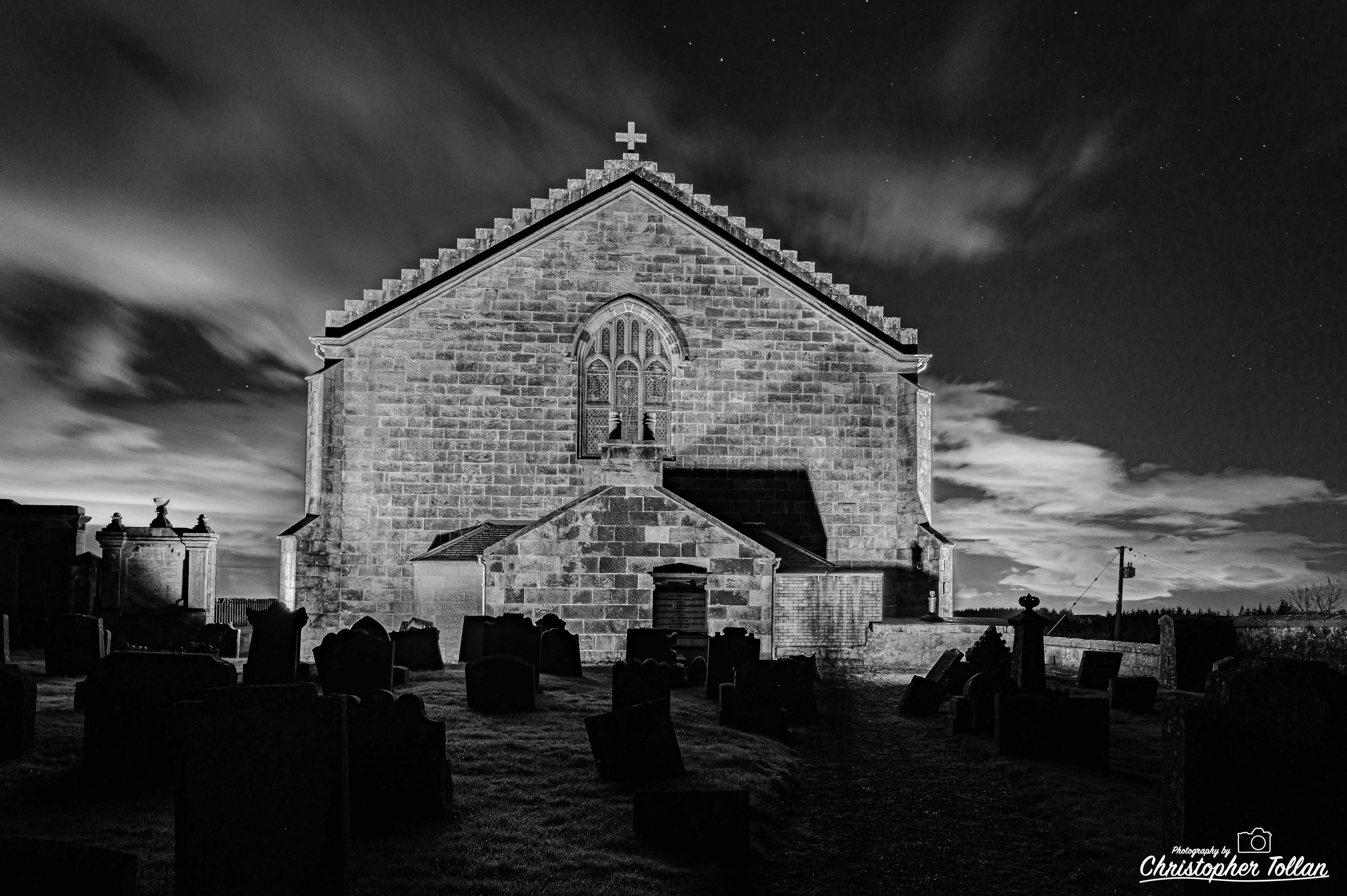
Salsburgh has a rich history, with evidence of settlements dating back to the Neolithic period. The village is known for its traditional sandstone buildings, some of which have been preserved and add to the area's charm.

Overall, Salsburgh is a tranquil and close-knit community that offers a peaceful lifestyle within reach of major cities and natural beauty.

If you have any feedback on the listing, please let us know in the comments section below.

Salsburgh Images

Images are sourced within 2km of 55.843492/-3.8742632 or Grid Reference NS8262. Thanks to Geograph Open Source API. All images are credited.

Rough grazing, Duntilland Hill
Road over Duntilland Hill The trees in a woodland strip have come on a bit since <a href="https://www.geograph.org.uk/photo/3033230">NS8364 : Minor Road on Duntilland Hill</a>
Road over Duntilland Hill
The trees in a woodland strip have come on a bit since NS8364 : Minor Road on Duntilland Hill
Woodland edge, Duntilland Hill Edge of a recently planted stripwood.
Woodland edge, Duntilland Hill
Edge of a recently planted stripwood.
Black Hill television transmitters
New transmitter mast, Black Hill The digital television transmitter  - seen under construction here <a href="https://www.geograph.org.uk/photo/1523221">NS8364 : Building the new Black Hill transmitter</a>
New transmitter mast, Black Hill
The digital television transmitter - seen under construction here NS8364 : Building the new Black Hill transmitter
Black Hill transmitters View from by Duntilland.
Black Hill transmitters
View from by Duntilland.
Duntilland Hill View across a young stripwood from the higher eastern summit. The mast has been stripped of its redundant microwave dishes, but is in use as a mobile telephone mast.
Duntilland Hill
View across a young stripwood from the higher eastern summit. The mast has been stripped of its redundant microwave dishes, but is in use as a mobile telephone mast.
Salsburgh View from Duntilland Hill
Salsburgh
View from Duntilland Hill
Dun Daugh
Dun Daugh
Welcome to Salsburgh On B7066 below Kirk o' Shotts Church which is represented on sign.

A similar structure has been built at west end of village. <a href="https://www.geograph.org.uk/photo/4677273">NS8162 : Welcome to Salsburgh (from the west)</a>
Welcome to Salsburgh
On B7066 below Kirk o' Shotts Church which is represented on sign. A similar structure has been built at west end of village. NS8162 : Welcome to Salsburgh (from the west)
Welcome to Salsburgh (from the west) Sign at what is known as the 'Engine Bridge' on the B7066 (former A8) matching the one east of the village. <a href="https://www.geograph.org.uk/photo/4665567">NS8463 : Welcome to Salsburgh</a>
Welcome to Salsburgh (from the west)
Sign at what is known as the 'Engine Bridge' on the B7066 (former A8) matching the one east of the village. NS8463 : Welcome to Salsburgh
Sunset  view View from Kirk o' Shotts over Salsburgh. Arran Hills on horizon.
Sunset view
View from Kirk o' Shotts over Salsburgh. Arran Hills on horizon.
The 'Riz' (reservoir) Memories of an area of open water behind a weir, all the way back to the slope on the right. 

Well silted up now but it was 45/50 years ago.
The 'Riz' (reservoir)
Memories of an area of open water behind a weir, all the way back to the slope on the right. Well silted up now but it was 45/50 years ago.
Salsburgh Moss With view to Riven Loch. Not woodland as shown on OS maps. 

Was drained in 1980's but these have been blocked to reinstate peat bog.
Salsburgh Moss
With view to Riven Loch. Not woodland as shown on OS maps. Was drained in 1980's but these have been blocked to reinstate peat bog.
Concrete Fenceposts Used to delineate boundaries along the course of A8 Glasgow-Edinburgh Road when it was constructed in 1930.
<a href="https://www.geograph.org.uk/photo/1250615">NS8162 : Double fence</a> 
<a href="https://www.geograph.org.uk/photo/1263781">NS9666 : View to Inchcross park</a>
Concrete Fenceposts
Used to delineate boundaries along the course of A8 Glasgow-Edinburgh Road when it was constructed in 1930. NS8162 : Double fence NS9666 : View to Inchcross park
B7066 approaching Salsburgh Former A8 Glasgow-Edinburgh road with its distinctive wide grass verge on one side. 
This used to be kept mown throughout the summer.
B7066 approaching Salsburgh
Former A8 Glasgow-Edinburgh road with its distinctive wide grass verge on one side. This used to be kept mown throughout the summer.
Fields beside the Shotts Burn at Salsburgh
Transmitters at Salsburgh Duntilland Hill in the background.
Transmitters at Salsburgh
Duntilland Hill in the background.
Show me another place!

Salsburgh is located at Grid Ref: NS8262 (Lat: 55.843492, Lng: -3.8742632)

Unitary Authority: North Lanarkshire

Police Authority: Lanarkshire

What 3 Words

///classed.version.delusions. Near Salsburgh, North Lanarkshire

Nearby Locations

Salsburgh

Related Wikis

Salsburgh

Salsburgh is a semi-rural former coal mining village in greenbelt farmland within the district of North Lanarkshire, Scotland. The closest major towns...

Airdrie and Shotts (UK Parliament constituency)

Airdrie and Shotts is a constituency of the UK House of Commons, located in central Scotland within the North Lanarkshire council area. It elects one Member...

Kate's Well

St. Catherine's Well or Kate's Well is a historical natural spring well of significant interest and sits on holy ground, at the foot of Kirk O' Shott's...

Shottskirk

Shottskirk, more commonly known as Kirk O'Shotts Parish Church, or affectionately "The M8 Church", is a local parish church located in Salsburgh, North...

Nearby Amenities

Located within 500m of 55.843492,-3.8742632
Crossing
Crossing: traffic_signals
Source: survey
Lat/Long: 55.8432044/-3.8723247
Salsburgh
Is In: North Lanarkshire
Place: village
Lat/Long: 55.8434334/-3.8741858
Post Office
Salsburgh Post Office
Addr Postcode: ML7 4LH
Branch: Salsburgh
Brand: Post Office
Brand Wikidata: Q1783168
Check Date: 2020-02-20
Contact Website: https://www.postoffice.co.uk/branch-finder/1285580/salsburgh
Ref Pol Id: 127948
Lat/Long: 55.8433388/-3.8744257
Mini Roundabout
Direction: clockwise
Source: survey
Lat/Long: 55.8441774/-3.8686038
Noexit: yes
Lat/Long: 55.8409173/-3.8749584
Turning Circle
Noexit: yes
Lat/Long: 55.8406003/-3.8753997
Mini Roundabout
Direction: clockwise
Source: survey
Lat/Long: 55.8418214/-3.8779596
Mini Roundabout
Direction: clockwise
Source: survey
Lat/Long: 55.8425999/-3.8777808
Mini Roundabout
Direction: clockwise
Source: survey
Lat/Long: 55.8444124/-3.8706089
Dolan's
Atm: yes
Shop: supermarket
Lat/Long: 55.8433487/-3.8743845
Shop: convenience
Source: survey
Lat/Long: 55.8427672/-3.872595
Post Box
Collection Times: Mo-Fr 09:00; Sa 07:00
Operator: Royal Mail
Post Box Type: lamp
Ref: ML7 15D
Royal Cypher: scottish_crown
Lat/Long: 55.843006/-3.8717251
Parking
Parking: layby
Source: Bing
Lat/Long: 55.8420422/-3.8767951
Post Box
Ref: ML7 121
Source: survey
Lat/Long: 55.8432441/-3.8748769
Atm
Source: survey
Lat/Long: 55.8433196/-3.874522
Power: pole
Lat/Long: 55.8443223/-3.8667522
Noexit: yes
Lat/Long: 55.8412493/-3.8731159
Bus Stop
Salsburgh, Main Street opp Grossart Street
Bus: yes
Public Transport: platform
Lat/Long: 55.8424088/-3.8782872
Bus Stop
Salsburgh, Main Street after Grossart Street
Bus: yes
Public Transport: platform
Lat/Long: 55.8427355/-3.8774347
Bus Stop
Salsburgh, Main Street opp David Street
Bus: yes
Public Transport: platform
Lat/Long: 55.8435266/-3.8743204
Bus Stop
Salsburgh, Main Street before David Street
Bus: yes
Public Transport: platform
Lat/Long: 55.8434869/-3.8740626
Bus Stop
Salsburgh, Main Street opp Gibson Street
Bus: yes
Public Transport: platform
Lat/Long: 55.8446783/-3.869815
Bus Stop
Salsburgh, Main Street before Gibson Street
Bus: yes
Public Transport: platform
Lat/Long: 55.8445443/-3.869907
Bus Stop
Salsburgh, Blackcroft Terrace before Sighthill Terrace
Bus: yes
Public Transport: platform
Lat/Long: 55.8434806/-3.8700163
Bus Stop
Salsburgh, Blackcroft Terrace after Margaret Avenue
Bus: yes
Public Transport: platform
Lat/Long: 55.8427366/-3.8729173
Bus Stop
Salsburgh, Camsdale Avenue after Duntilland Avenue
Bus: yes
Public Transport: platform
Lat/Long: 55.8414469/-3.8745143
Bus Stop
Salsburgh, Carvale Avenue after Camsdale Avenue
Bus: yes
Public Transport: platform
Lat/Long: 55.8413201/-3.8735732
Bus Stop
Salsburgh, Carvale Avenue after Sighthill Terrace
Bus: yes
Public Transport: platform
Lat/Long: 55.8420673/-3.8706736
Bus Stop
Salsburgh, Kirkview Avenue after Carvale Avenue
Bus: yes
Public Transport: platform
Lat/Long: 55.8435806/-3.868959
Generator Method: photovoltaic
Generator Output Electricity: yes
Generator Source: solar
Generator Type: solar_photovoltaic_panel
Location: roof
Power: generator
Lat/Long: 55.8442211/-3.8719263
Generator Method: photovoltaic
Generator Output Electricity: yes
Generator Source: solar
Generator Type: solar_photovoltaic_panel
Location: roof
Power: generator
Lat/Long: 55.8429644/-3.8767935
Generator Method: photovoltaic
Generator Output Electricity: yes
Generator Source: solar
Generator Type: solar_photovoltaic_panel
Location: roof
Power: generator
Lat/Long: 55.8424491/-3.8788995
Generator Method: photovoltaic
Generator Output Electricity: yes
Generator Source: solar
Generator Type: solar_photovoltaic_panel
Location: roof
Power: generator
Lat/Long: 55.842202/-3.8785208
Generator Method: photovoltaic
Generator Output Electricity: yes
Generator Source: solar
Generator Type: solar_photovoltaic_panel
Location: roof
Power: generator
Lat/Long: 55.8421813/-3.87862
Generator Method: photovoltaic
Generator Output Electricity: yes
Generator Source: solar
Generator Type: solar_photovoltaic_panel
Location: roof
Power: generator
Lat/Long: 55.8421555/-3.8787361
Generator Method: photovoltaic
Generator Output Electricity: yes
Generator Source: solar
Generator Type: solar_photovoltaic_panel
Location: roof
Power: generator
Lat/Long: 55.8421317/-3.878828
Generator Method: photovoltaic
Generator Output Electricity: yes
Generator Source: solar
Generator Type: solar_photovoltaic_panel
Location: roof
Power: generator
Lat/Long: 55.8420711/-3.8789963
Generator Method: photovoltaic
Generator Output Electricity: yes
Generator Source: solar
Generator Type: solar_photovoltaic_panel
Location: roof
Power: generator
Lat/Long: 55.8420354/-3.8787524
Generator Method: photovoltaic
Generator Output Electricity: yes
Generator Source: solar
Generator Type: solar_photovoltaic_panel
Location: roof
Power: generator
Lat/Long: 55.8419834/-3.8787242
Generator Method: photovoltaic
Generator Output Electricity: yes
Generator Source: solar
Generator Type: solar_photovoltaic_panel
Location: roof
Power: generator
Lat/Long: 55.8419232/-3.8786692
Generator Method: photovoltaic
Generator Output Electricity: yes
Generator Source: solar
Generator Type: solar_photovoltaic_panel
Location: roof
Power: generator
Lat/Long: 55.8418388/-3.8789522
Generator Method: photovoltaic
Generator Output Electricity: yes
Generator Source: solar
Generator Type: solar_photovoltaic_panel
Location: roof
Power: generator
Lat/Long: 55.8418117/-3.8790863
Generator Method: photovoltaic
Generator Output Electricity: yes
Generator Source: solar
Generator Type: solar_photovoltaic_panel
Location: roof
Power: generator
Lat/Long: 55.8417869/-3.8791842
Generator Method: photovoltaic
Generator Output Electricity: yes
Generator Source: solar
Generator Type: solar_photovoltaic_panel
Location: roof
Power: generator
Lat/Long: 55.8421274/-3.8783727
Generator Method: photovoltaic
Generator Output Electricity: yes
Generator Source: solar
Generator Type: solar_photovoltaic_panel
Location: roof
Power: generator
Lat/Long: 55.8420704/-3.8783331
Generator Method: photovoltaic
Generator Output Electricity: yes
Generator Source: solar
Generator Type: solar_photovoltaic_panel
Location: roof
Power: generator
Lat/Long: 55.8420116/-3.8782914
Generator Method: photovoltaic
Generator Output Electricity: yes
Generator Source: solar
Generator Type: solar_photovoltaic_panel
Location: roof
Power: generator
Lat/Long: 55.8419557/-3.8782579
Generator Method: photovoltaic
Generator Output Electricity: yes
Generator Source: solar
Generator Type: solar_photovoltaic_panel
Location: roof
Power: generator
Lat/Long: 55.8418632/-3.8786335
Generator Method: photovoltaic
Generator Output Electricity: yes
Generator Source: solar
Generator Type: solar_photovoltaic_panel
Location: roof
Power: generator
Lat/Long: 55.841684/-3.8794515
Generator Method: photovoltaic
Generator Output Electricity: yes
Generator Source: solar
Generator Type: solar_photovoltaic_panel
Location: roof
Power: generator
Lat/Long: 55.8417428/-3.8794797
Generator Method: photovoltaic
Generator Output Electricity: yes
Generator Source: solar
Generator Type: solar_photovoltaic_panel
Location: roof
Power: generator
Lat/Long: 55.841803/-3.8795307
Generator Method: photovoltaic
Generator Output Electricity: yes
Generator Source: solar
Generator Type: solar_photovoltaic_panel
Location: roof
Power: generator
Lat/Long: 55.8418572/-3.8795629
Generator Method: photovoltaic
Generator Output Electricity: yes
Generator Source: solar
Generator Type: solar_photovoltaic_panel
Location: roof
Power: generator
Lat/Long: 55.841937/-3.8796219
Generator Method: photovoltaic
Generator Output Electricity: yes
Generator Source: solar
Generator Type: solar_photovoltaic_panel
Location: roof
Power: generator
Lat/Long: 55.8419905/-3.8796581
Generator Method: photovoltaic
Generator Output Electricity: yes
Generator Source: solar
Generator Type: solar_photovoltaic_panel
Location: roof
Power: generator
Lat/Long: 55.8416902/-3.8725466
The data included in this document is from www.openstreetmap.org. The data is made available under ODbL.

Have you been to Salsburgh?

Leave your review of Salsburgh below (or comments, questions and feedback).