Blackburn

Settlement in West Lothian

Scotland

Blackburn

View to Mid Seat of Foulshiels Herd of cattle had just entered field
View to Mid Seat of Foulshiels Credit: Jim Smillie

Blackburn is a small town located in West Lothian, Scotland. Situated about 24 kilometers west of Edinburgh, it lies on the southern bank of the River Almond. With a population of approximately 5,000 people, Blackburn is a close-knit community that offers a peaceful and picturesque setting.

The town has a rich history that dates back to the 12th century when it was established as a royal burgh. Over the years, Blackburn has seen steady growth and development, becoming a thriving center for local commerce and industry.

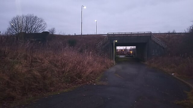
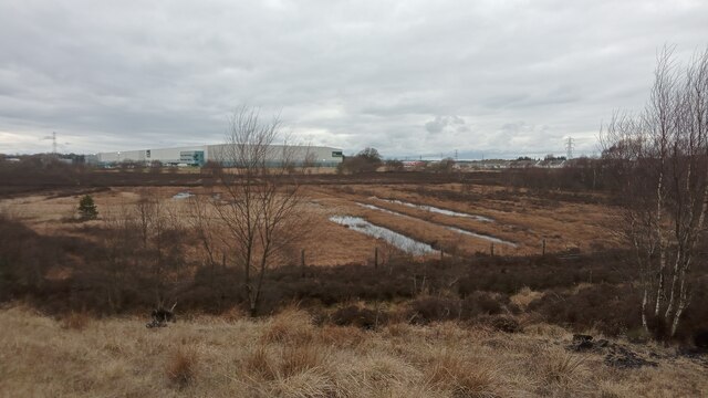
One of the notable features of Blackburn is its stunning natural surroundings. The town is surrounded by beautiful countryside, making it an ideal location for outdoor enthusiasts. There are several parks and green spaces, including the popular Blackburn Woods, which provide ample opportunities for walking, cycling, and other recreational activities.

Blackburn has a strong sense of community and is well-served by various amenities. The town boasts a range of shops, restaurants, and cafes, ensuring that residents have easy access to everyday necessities. There are also several schools, a library, and a community center, which contribute to the town's vibrant social fabric.

Transportation links in Blackburn are excellent, with regular bus services connecting the town to neighboring areas. Additionally, the nearby M8 motorway provides convenient access to both Edinburgh and Glasgow, making Blackburn an attractive place for commuters.

Overall, Blackburn, West Lothian is a charming town that offers a blend of natural beauty, a rich history, and a strong community spirit.

If you have any feedback on the listing, please let us know in the comments section below.

Blackburn Images

Images are sourced within 2km of 55.871095/-3.6229011 or Grid Reference NS9865. Thanks to Geograph Open Source API. All images are credited.

View to Mid Seat of Foulshiels Herd of cattle had just entered field
View to Mid Seat of Foulshiels
Herd of cattle had just entered field
Site of Former Pond On the East side of the North end of the brilliantly-named Hen's Nest Road there is a mazy network of paths, mostly through woodland. This is the only real bit of open ground in amongst it all, and this spot is just off one of the soft (ie muddy) paths. Paper maps still show a small pond here, and it is obvious from the lower vegetation and fresh gravelly surface that it can't have disappeared that long ago.
As is the case with a lot of laid-out recreational walking areas in West Lothian, the paths sit on the site of a former mineworks, in this case Whitrigg Colliery. Therefore it is a possibility that the water was polluted, and that the pond was deemed too small to go to the trouble of planting reeds in, in order to lessen the pollution, so just got filled in.
Site of Former Pond
On the East side of the North end of the brilliantly-named Hen's Nest Road there is a mazy network of paths, mostly through woodland. This is the only real bit of open ground in amongst it all, and this spot is just off one of the soft (ie muddy) paths. Paper maps still show a small pond here, and it is obvious from the lower vegetation and fresh gravelly surface that it can't have disappeared that long ago. As is the case with a lot of laid-out recreational walking areas in West Lothian, the paths sit on the site of a former mineworks, in this case Whitrigg Colliery. Therefore it is a possibility that the water was polluted, and that the pond was deemed too small to go to the trouble of planting reeds in, in order to lessen the pollution, so just got filled in.
Pet Cemetery near East Whitburn While it is fairly common to see occasional tributes to former pets dotted about local walking paths, I have never encountered anything on this scale before. I counted at least 50 graves without trying very hard; there are no doubt far more further back from the path than I ventured. The vast majority of the graves sit on one side of this path but there are a few more at a path junction not too far left of camera - one of these came with such an emotional epitaph I did wonder for a while whether there was actually a human child buried there!
The graves are at the top of Whitrigg Bing, a landscaped spoil heap which owes its existence to the former colliery based here. The bing is on the edge of Whitrigg Community Woodland - a faded wooden sign leading from the straight path running along the West of the site indicated Forestry Commission (or whatever they are called these days - like most organizations they too used recent lockdowns to undertake unnecessary rebranding exercises) involvement.
Pet Cemetery near East Whitburn
While it is fairly common to see occasional tributes to former pets dotted about local walking paths, I have never encountered anything on this scale before. I counted at least 50 graves without trying very hard; there are no doubt far more further back from the path than I ventured. The vast majority of the graves sit on one side of this path but there are a few more at a path junction not too far left of camera - one of these came with such an emotional epitaph I did wonder for a while whether there was actually a human child buried there! The graves are at the top of Whitrigg Bing, a landscaped spoil heap which owes its existence to the former colliery based here. The bing is on the edge of Whitrigg Community Woodland - a faded wooden sign leading from the straight path running along the West of the site indicated Forestry Commission (or whatever they are called these days - like most organizations they too used recent lockdowns to undertake unnecessary rebranding exercises) involvement.
Marshland at Easter Inch Moss I suppose that this does just about qualify as a pond, as indicated on the map, but it is really just the wettest bit of a fairly extensive marsh. Wellingtons are recommended, particularly if heading from the West, as the water was regularly way over the top of my boots when on the 'ground' beyond the trees.
There must have been about twenty smallish birds taking cover in the long grass around the pond - that is presuming that they all took to the air when I approached. The presence of a shooting platform in the tree straight ahead hints that there are probably sometimes bigger water birds around this area too.
Marshland at Easter Inch Moss
I suppose that this does just about qualify as a pond, as indicated on the map, but it is really just the wettest bit of a fairly extensive marsh. Wellingtons are recommended, particularly if heading from the West, as the water was regularly way over the top of my boots when on the 'ground' beyond the trees. There must have been about twenty smallish birds taking cover in the long grass around the pond - that is presuming that they all took to the air when I approached. The presence of a shooting platform in the tree straight ahead hints that there are probably sometimes bigger water birds around this area too.
Bridge over Former Road This road once led to a huge truck and tractor manufacturing plant owned by British Leyland; it now leads to a footpath running alongside the houses at the South end of the Wester Inch area of Bathgate, which occupies the land the former factory was situated on. A railway line once ran under the bridge to the left, transporting coal from Riddochill Colliery to Bathgate's former second station, 'Bathgate Lower'.
There is an interesting (and easily-found online) report detailing the reasons behind the factory's demise, written just prior to its eventual closure in the mid 1980s, by none other than Alex Salmond, former First Minister of Scotland. It is obviously therefore very much of its time, and doesn't anticipate the extent of the subsequent decline in British manufacturing and, as would be expected from Mr Salmond, focuses on perceived regional injustices (which may or may not be the case), but reading it today you get the feeling that the writing was already on the wall. It is astounding these days to learn that in the mid 1960s, 40% of all vehicles on the road were produced by British Leyland (or whatever it happened to be calling itself at the time) and its subsidiaries.
The road under the bridge was actually just a slip road leading from and to the road above - now called the A7066 but previously the A8, which before the M8 motorway was built was the main road connecting Edinburgh and Glasgow.
Behind camera to the right is the old slip road, now covered in thick moss but still very obvious.
Bridge over Former Road
This road once led to a huge truck and tractor manufacturing plant owned by British Leyland; it now leads to a footpath running alongside the houses at the South end of the Wester Inch area of Bathgate, which occupies the land the former factory was situated on. A railway line once ran under the bridge to the left, transporting coal from Riddochill Colliery to Bathgate's former second station, 'Bathgate Lower'. There is an interesting (and easily-found online) report detailing the reasons behind the factory's demise, written just prior to its eventual closure in the mid 1980s, by none other than Alex Salmond, former First Minister of Scotland. It is obviously therefore very much of its time, and doesn't anticipate the extent of the subsequent decline in British manufacturing and, as would be expected from Mr Salmond, focuses on perceived regional injustices (which may or may not be the case), but reading it today you get the feeling that the writing was already on the wall. It is astounding these days to learn that in the mid 1960s, 40% of all vehicles on the road were produced by British Leyland (or whatever it happened to be calling itself at the time) and its subsidiaries. The road under the bridge was actually just a slip road leading from and to the road above - now called the A7066 but previously the A8, which before the M8 motorway was built was the main road connecting Edinburgh and Glasgow. Behind camera to the right is the old slip road, now covered in thick moss but still very obvious.
South Bank of the Almond It is quite a nice short walk along the South bank of the Almond, between the two roads running North to South, South of Blackburn. There are lots of flat banks, steep banks and hollows, none of which appear to be the result of industrial activity, unlike a lot of the features in West Lothian, big and small. And since there are no paths, there is virtually no litter.
The river, still fairly small at this point, is just to the left of camera.
South Bank of the Almond
It is quite a nice short walk along the South bank of the Almond, between the two roads running North to South, South of Blackburn. There are lots of flat banks, steep banks and hollows, none of which appear to be the result of industrial activity, unlike a lot of the features in West Lothian, big and small. And since there are no paths, there is virtually no litter. The river, still fairly small at this point, is just to the left of camera.
Open Land behind Blackburn Only a small fraction of this grid-square isn't taken over by urban development.  This land sits between houses at the NorthEast of Blackburn and the M8 motorway; it contains a number of paths - unmarked on even the most detailed online mapping - and a great deal of rubbish. 
Like a lot of semi-wasteland it has a certain appeal and feeling of discovery about it. The piles of mossy stones in the foreground sadly don't seem to tie in with any previous structure around here though - they are probably just the result of ground getting cleared for woodland or drainage ditches.
Open Land behind Blackburn
Only a small fraction of this grid-square isn't taken over by urban development. This land sits between houses at the NorthEast of Blackburn and the M8 motorway; it contains a number of paths - unmarked on even the most detailed online mapping - and a great deal of rubbish. Like a lot of semi-wasteland it has a certain appeal and feeling of discovery about it. The piles of mossy stones in the foreground sadly don't seem to tie in with any previous structure around here though - they are probably just the result of ground getting cleared for woodland or drainage ditches.
A Disintegrating Tree It is unlikely this beautiful old tree will be around for many more years, so catch it while you can! It isn't huge; it's more the fact that it looks like an old tree should look that makes it special. The wood on the inside of the hollow trunk is damp and flaking, but not properly rotten yet.
It sits just off a muddy path leading into a small woodland, which is opposite a long line of old terraced garages. The nailed-on sign is a bit curious - maybe it pointed somewhere once, but nowadays it just points to some thickets at the back of garden fences on Beechwood Gardens.
A Disintegrating Tree
It is unlikely this beautiful old tree will be around for many more years, so catch it while you can! It isn't huge; it's more the fact that it looks like an old tree should look that makes it special. The wood on the inside of the hollow trunk is damp and flaking, but not properly rotten yet. It sits just off a muddy path leading into a small woodland, which is opposite a long line of old terraced garages. The nailed-on sign is a bit curious - maybe it pointed somewhere once, but nowadays it just points to some thickets at the back of garden fences on Beechwood Gardens.
Southern End of The Moss Well, that's what I'm saying anyway! 'The Moss' appears on old maps highlighting an area North of here, and between the Northern part of the bog (mosses form bogs, and the words seem interchangeable in this part of Scotland - it is therefore a very unimaginative name) and here once stood Riddochill Colliery. Now it is the M8 motorway that separates the two sections.
OS maps inexplicably show this as being an area of coniferous woodland. It is in fact a half-bog, with small thickets of deciduous trees dotted about. And lots of heather at various points like here, though there are large grassy areas too. There is always some moss kicking about somewhere.
If you exit the M8 at Junction 4 and head towards Blackburn/Whitburn there is a gravel area in front of a gate on the left of the short road leading from the roundabout. For some reason there is a hardcore track leading for quite a way from there into this area. It stops just short of a load of power lines so it may have been put down to access these - it doesn't appear on any old maps. There was a proposal to build about 20 glamping pods near here several years ago, so it could possibly have something to do with that though. This was rejected on account of the proposed development's potential for being too noisy, and the odours generated by outdoor cooking. It is interesting how powerful public opinion can be when not dealing with multimillion pound housing developers.
On the right of the pictures some light-coloured corrugated plastic dams are visible. These serve to increase the water level in a drain, meaning there is some attempt being made to restore the water level in the bog, but by whom I have not been able to find out so far.
Southern End of The Moss
Well, that's what I'm saying anyway! 'The Moss' appears on old maps highlighting an area North of here, and between the Northern part of the bog (mosses form bogs, and the words seem interchangeable in this part of Scotland - it is therefore a very unimaginative name) and here once stood Riddochill Colliery. Now it is the M8 motorway that separates the two sections. OS maps inexplicably show this as being an area of coniferous woodland. It is in fact a half-bog, with small thickets of deciduous trees dotted about. And lots of heather at various points like here, though there are large grassy areas too. There is always some moss kicking about somewhere. If you exit the M8 at Junction 4 and head towards Blackburn/Whitburn there is a gravel area in front of a gate on the left of the short road leading from the roundabout. For some reason there is a hardcore track leading for quite a way from there into this area. It stops just short of a load of power lines so it may have been put down to access these - it doesn't appear on any old maps. There was a proposal to build about 20 glamping pods near here several years ago, so it could possibly have something to do with that though. This was rejected on account of the proposed development's potential for being too noisy, and the odours generated by outdoor cooking. It is interesting how powerful public opinion can be when not dealing with multimillion pound housing developers. On the right of the pictures some light-coloured corrugated plastic dams are visible. These serve to increase the water level in a drain, meaning there is some attempt being made to restore the water level in the bog, but by whom I have not been able to find out so far.
Ruin at Blackburn Hall Holdings This ruined stone building was built at some stage between the 1850s and the 1890s. Although small, the presence of the doorway and what look like spaces for windows, indicate that somebody - probably a farm worker (or farm workers) - once lived here. It is still shown as having a roof in the late 1950s.
Behind the ruin is one of the ancillary buildings at 2 Blackburn Hall Holdings. No 1, an old farm which was originally just called Blackburn Hall, and predates the dozen or so holdings (as does the ruin), is opposite, behind and to the left of shot.
Ruin at Blackburn Hall Holdings
This ruined stone building was built at some stage between the 1850s and the 1890s. Although small, the presence of the doorway and what look like spaces for windows, indicate that somebody - probably a farm worker (or farm workers) - once lived here. It is still shown as having a roof in the late 1950s. Behind the ruin is one of the ancillary buildings at 2 Blackburn Hall Holdings. No 1, an old farm which was originally just called Blackburn Hall, and predates the dozen or so holdings (as does the ruin), is opposite, behind and to the left of shot.
Grass, heather and ditches This was quite an odd spectacle to stumble across, looking a little like the remnants of some exotic irrigation farming system. Recent OS maps provide a big clue as until a few years ago there were trees in the field immediately ahead. Therefore as this is boggy land presumably the ridges and ditches were put in both fields  in order to keep trees above water.
The lines in the field further away are more complete, and present throughout; the ridges are covered in heather whilst the ditches, though still wet, have grass growing in them.
It is possible, if care is taken, to get across both fields without getting your feet wet.
Grass, heather and ditches
This was quite an odd spectacle to stumble across, looking a little like the remnants of some exotic irrigation farming system. Recent OS maps provide a big clue as until a few years ago there were trees in the field immediately ahead. Therefore as this is boggy land presumably the ridges and ditches were put in both fields in order to keep trees above water. The lines in the field further away are more complete, and present throughout; the ridges are covered in heather whilst the ditches, though still wet, have grass growing in them. It is possible, if care is taken, to get across both fields without getting your feet wet.
Drainage Basin, Easter Inch This  narrow basin is hidden away between Easter Inch Industrial Estate and the road to Easter Inch Farm Steadings. There is one inlet at its Southern end leading from the industrial units and no obvious outlet, so maybe it just drains into the land. Which seems odd as there is a great deal of noisy water moving along somewhere behind the concrete wall; there is also an overflow built into the wall high above the little drainage area.
The liferings seem a bit unnecessary, but perhaps it gets deeper sometimes.
Drainage Basin, Easter Inch
This narrow basin is hidden away between Easter Inch Industrial Estate and the road to Easter Inch Farm Steadings. There is one inlet at its Southern end leading from the industrial units and no obvious outlet, so maybe it just drains into the land. Which seems odd as there is a great deal of noisy water moving along somewhere behind the concrete wall; there is also an overflow built into the wall high above the little drainage area. The liferings seem a bit unnecessary, but perhaps it gets deeper sometimes.
A801 joins the M8 at junction 4
Mill Road Mill Road, Blackburn after overnight snow.
Mill Road
Mill Road, Blackburn after overnight snow.
Reed beds at Redmill Industrial Estate These reed beds filter the water that drains from the bing of the former Whitrigg Pit before it enters the Latch burn.
Reed beds at Redmill Industrial Estate
These reed beds filter the water that drains from the bing of the former Whitrigg Pit before it enters the Latch burn.
Spring sunshine in Whitrigg woods Footpath through the Whitrigg woods on the former mine workings of Whitrigg Mine.
Spring sunshine in Whitrigg woods
Footpath through the Whitrigg woods on the former mine workings of Whitrigg Mine.
M8 westbound
M8 westbound
M8 westbound
M8 westbound
Show me another place!

Blackburn is located at Grid Ref: NS9865 (Lat: 55.871095, Lng: -3.6229011)

Unitary Authority: West Lothian

Police Authority: The Lothians and Scottish Borders

What 3 Words

///shipwreck.reject.delivers. Near Blackburn, West Lothian

Nearby Locations

Blackburn

Related Wikis

Blackburn, West Lothian

Blackburn is a town in West Lothian, Scotland, near both Bathgate and Livingston, two of the larger towns in the county. It is situated approximately 20...

Blackburn United F.C.

Blackburn United Football Club are a Scottish football club from the town of Blackburn, West Lothian. The team plays at Tier 6 of the Scottish Football...

St Kentigern's Academy

St. Kentigern's Academy is a Roman Catholic, comprehensive school in Blackburn, West Lothian, Scotland. The school was built in 1973 and refurbished in...

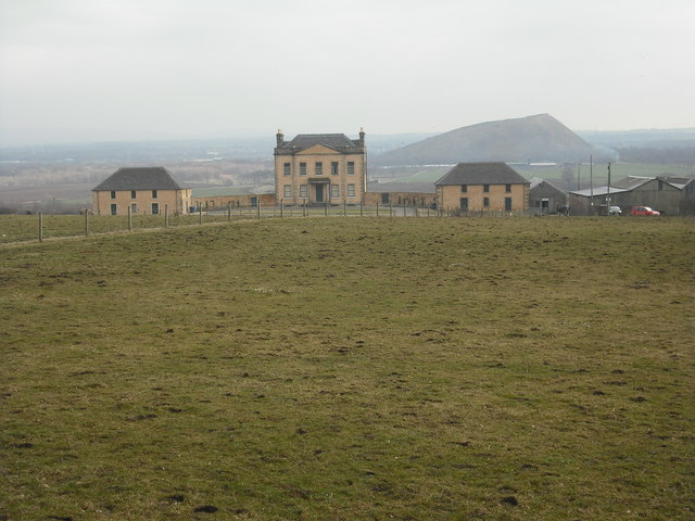
Blackburn House, West Lothian

Blackburn House is a category A-listed Georgian house, situated between Blackburn and Seafield near Bathgate in West Lothian, Scotland. The house comprises...

Foulshiels railway station

Foulshiels railway station served the town of Bathgate, West Lothian, Scotland, from 1850 to 1852 on the Longridge and Bathgate Extension Railway. ��2...

Seafield, West Lothian

Seafield is a small village in West Lothian, Scotland. Seafield lies 1+1⁄4 miles (2.0 km) east of Blackburn, 2 miles (3.2 km) southeast of Bathgate (grid...

Whitburn railway station

Whitburn railway station served the town of East Whitburn, West Lothian, Scotland from 1850 to 1930 on the Longridge and Bathgate Extension Railway....

East Whitburn

East Whitburn is a small village in Scottish county of West Lothian. Bordering the mining town of Whitburn,East Whitburn has grown significantly in the...

Nearby Amenities

Located within 500m of 55.871095,-3.6229011
Blackburn
Is In: West Lothian, Scotland, UK
Name Lt: Blakbernas
Place: town
Population: 5730
Population Date: mid-2020 estimate
Source Population: wikipedia
Wikidata: Q1016707
Wikipedia: en:Blackburn, West Lothian
Lat/Long: 55.8712745/-3.6227367
Traffic Signals
Traffic Signals: signal
Lat/Long: 55.8710947/-3.6229714
Traffic Signals
Lat/Long: 55.8710936/-3.623533
Crossing
Button Operated: yes
Crossing: traffic_signals
Crossing Ref: pelican
Tactile Paving: yes
Lat/Long: 55.8747076/-3.6240379
Post Box
Collection Times: Mo-Fr 16:30; Sa 07:30
Operator: Royal Mail
Post Box Type: lamp
Ref: EH47 40
Royal Cypher: scottish_crown
Source: survey
Lat/Long: 55.8722393/-3.6300492
Post Box
Collection Times: Mo-Fr 16:15; Sa 07:30
Post Box Type: pillar
Ref: EH47 42
Royal Cypher: GVIR
Royal Cypher Wikidata: Q33102169
Source: survey
Lat/Long: 55.8751792/-3.6240561
Barrier: turnstile
Lat/Long: 55.8739024/-3.6193005
Barrier: turnstile
Lat/Long: 55.8738889/-3.6194802
Bus Stop
Naptan AtcoCode: 6290BB20
Naptan NaptanCode: 95623789
Lat/Long: 55.874461/-3.618053
Bus Stop
Naptan AtcoCode: 6290BB19
Naptan NaptanCode: 95623787
Lat/Long: 55.8745965/-3.6180476
Fast Food
The Qualifryer
Addr City: Bathgate
Addr Housenumber: 12
Addr Place: The Mill Centre
Addr Postcode: EH47 7LQ
Addr Suburb: Blackburn
Cuisine: fish_and_chips
Fhrs Id: 587732
Source Addr: FHRS Open Data
Lat/Long: 55.8745046/-3.6224541
Recycling
Recycling Glass Bottles: yes
Recycling Type: container
Lat/Long: 55.87443/-3.6220406
Entrance: yes
Lat/Long: 55.8744314/-3.6227897
Post Box
Collection Times: Mo-Fr 16:30; Sa 12:00
Operator: Royal Mail
Post Box Type: pillar
Ref: EH47 47
Royal Cypher: scottish_crown
Lat/Long: 55.874449/-3.6221045
Ladbrokes
Brand: Ladbrokes
Brand Wikidata: Q1799875
Brand Wikipedia: en:Ladbrokes Coral
Shop: bookmaker
Lat/Long: 55.8744883/-3.6226309
Toilets
Fee: yes
Unisex: yes
Lat/Long: 55.8745096/-3.6222901
Betfred
Brand: Betfred
Brand Wikidata: Q4897425
Brand Wikipedia: en:Betfred
Shop: bookmaker
Lat/Long: 55.8746849/-3.6235651
Day-Today
Shop: convenience
Lat/Long: 55.8710089/-3.6212015
Atm
Opening Hours: 24/7
Lat/Long: 55.8710258/-3.6212956
Thomas Grieve & Son
Phone: +44 1506 856580
Shop: funeral_directors
Website: https://www.thomasgrieve-andson.co.uk/
Lat/Long: 55.8710123/-3.623245
Bus Stop
Bench: yes
Bus: yes
Layby: yes
Public Transport: platform
Shelter: yes
Lat/Long: 55.8710088/-3.6222073
Pub
Turf Bar
Lat/Long: 55.8711776/-3.6231436
Fast Food
City Garden
Addr City: Bathgate
Addr Housenumber: 16
Addr Postcode: EH47 7QU
Addr Street: East Main Street
Addr Suburb: Blackburn
Cuisine: chinese
Fhrs Id: 587649
Takeaway: only
Lat/Long: 55.871009/-3.6227727
Bus Stop
Bench: no
Shelter: no
Lat/Long: 55.8715286/-3.6159726
Bus Stop
Bench: no
Shelter: no
Lat/Long: 55.8712437/-3.6179483
Bus Stop
Bench: no
Shelter: no
Lat/Long: 55.8712979/-3.6180047
Bus Stop
Bench: yes
Shelter: yes
Lat/Long: 55.8711589/-3.6243843
Bus Stop
Bench: yes
Naptan AtcoCode: 6290BB29
Naptan NaptanCode: 95624252
Shelter: yes
Lat/Long: 55.8710598/-3.6262318
Bus Stop
Bench: yes
Naptan AtcoCode: 6290BB11
Naptan NaptanCode: 95623784
Shelter: yes
Lat/Long: 55.8709191/-3.6237278
Traffic Calming: island
Lat/Long: 55.8713483/-3.6173422
Traffic Calming: island
Lat/Long: 55.8715647/-3.6153233
Traffic Calming: island
Lat/Long: 55.8710654/-3.6298686
Traffic Calming: island
Lat/Long: 55.8711065/-3.6264968
Bus Stop
Bus: yes
Public Transport: platform
Lat/Long: 55.8743775/-3.623824
Scotmid
Addr City: Blackburn
Addr Postcode: EH47 7LH
Brand: Scotmid
Brand Wikidata: Q7435719
Brand Wikipedia: en:Scotmid
Shop: supermarket
Lat/Long: 55.8743717/-3.6234272
Bicycle Parking
Bicycle Parking: stands
Capacity: 4
Lat/Long: 55.8740388/-3.6190262
Fast Food
Lat/Long: 55.8752225/-3.6245229
Pub
The Happy Valley
Lat/Long: 55.8753515/-3.6245721
Car Wash
Lat/Long: 55.8713289/-3.6206899
Tan Shack
Beauty: tanning
Shop: beauty
Lat/Long: 55.8712194/-3.6203054
Power: pole
Lat/Long: 55.8706414/-3.6245039
Power: pole
Lat/Long: 55.8700666/-3.6244985
Power: pole
Lat/Long: 55.8694315/-3.6245012
Power: pole
Lat/Long: 55.8688521/-3.6244825
Power: pole
Lat/Long: 55.8680861/-3.6245012
Power: pole
Lat/Long: 55.8673245/-3.624512
Power: pole
Lat/Long: 55.8668113/-3.6244342
The data included in this document is from www.openstreetmap.org. The data is made available under ODbL.

Have you been to Blackburn?

Leave your review of Blackburn below (or comments, questions and feedback).