Black Horse Drove

Settlement in Cambridgeshire East Cambridgeshire

England

Black Horse Drove

Brandon Creek (Great River Ouse, Little Ouse): aerial 2022
Brandon Creek (Great River Ouse, Little Ouse): aerial 2022 Credit: Chris

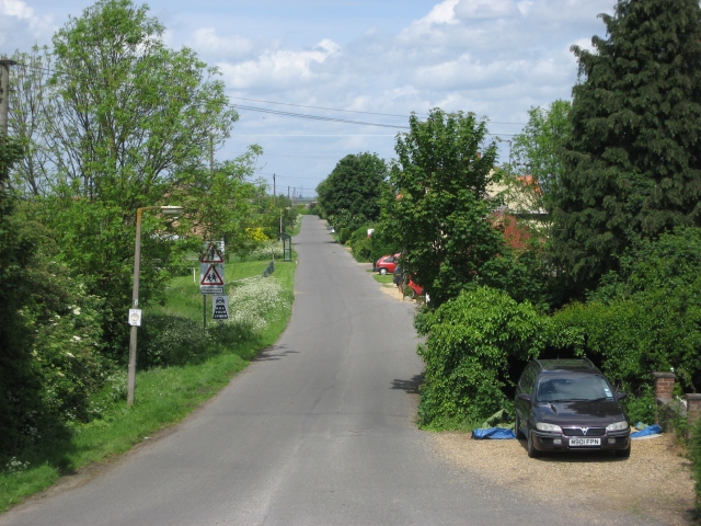
Black Horse Drove is a small village located in the county of Cambridgeshire, England. Situated approximately 12 miles northeast of the city of Cambridge, it falls within the district of East Cambridgeshire. The village is nestled in the picturesque Fenland countryside, known for its flat, marshy terrain.

The name Black Horse Drove derives from the historical use of a droveway, or drove road, which was a path used for driving livestock, particularly horses, through the area. Today, the village retains its rural charm and is characterized by a mix of traditional cottages and modern houses.

Although small in size, Black Horse Drove boasts a close-knit community that takes pride in its local heritage. The village is home to a 17th-century pub, The Black Horse Inn, which serves as a focal point for social gatherings and a hub of village life. The pub offers a warm and welcoming atmosphere, serving locally sourced food and ales.

Nature lovers are drawn to Black Horse Drove for its proximity to the vast open landscapes of the Cambridgeshire Fens. The area is renowned for its unique wildlife and birdlife, making it an ideal destination for birdwatching and nature walks. The nearby Wicken Fen National Nature Reserve provides further opportunities to explore the diverse flora and fauna of the region.

Overall, Black Horse Drove offers a tranquil and idyllic setting, making it a desirable place to live for those seeking a peaceful countryside lifestyle, while still being within easy reach of major towns and cities.

If you have any feedback on the listing, please let us know in the comments section below.

Black Horse Drove Images

Images are sourced within 2km of 52.501279/0.343985 or Grid Reference TL5991. Thanks to Geograph Open Source API. All images are credited.

Brandon Creek (Great River Ouse, Little Ouse): aerial 2022
On the Ouse Valley Way - opposite Black Horse Drove
Picnic site by the Great Ouse This picnic site is a pleasant stopping-place both for boaters on the Great Ouse and for drivers on the A10.
Picnic site by the Great Ouse
This picnic site is a pleasant stopping-place both for boaters on the Great Ouse and for drivers on the A10.
Sailing along the River Great Ouse Not sure how to describe this boat - maybe a yacht or a cabin cruiser with sails?
A building seen in the distance is the top of <a href="https://www.geograph.org.uk/photo/2263147">TL6192 : House beside River Great Ouse south-west of Southery</a> .
Sailing along the River Great Ouse
Not sure how to describe this boat - maybe a yacht or a cabin cruiser with sails? A building seen in the distance is the top of TL6192 : House beside River Great Ouse south-west of Southery .
Back of the Ship Inn, Brandon Creek A 17th century inn <span class="nowrap"><a title="http://www.theshipbrandoncreek.co.uk/" rel="nofollow ugc noopener" href="http://www.theshipbrandoncreek.co.uk/">Link</a><img style="margin-left:2px;" alt="External link" title="External link - shift click to open in new window" src="https://s1.geograph.org.uk/img/external.png" width="10" height="10"/></span> located on a promontory at the confluence of the Great Ouse and Little Ouse rivers.
This view from the Great Ouse shows moorings for boaters visiting the pub.
Back of the Ship Inn, Brandon Creek
A 17th century inn LinkExternal link located on a promontory at the confluence of the Great Ouse and Little Ouse rivers. This view from the Great Ouse shows moorings for boaters visiting the pub.
House near Brandon Creek The ground floor of the house is hidden by the high bank of the River Great Ouse. The window surrounds have a noticeable slant from the horizontal - this would most likely be due to shrinkage of the underlying peaty soil.
House near Brandon Creek
The ground floor of the house is hidden by the high bank of the River Great Ouse. The window surrounds have a noticeable slant from the horizontal - this would most likely be due to shrinkage of the underlying peaty soil.
South-east from the A10 Afternoon sunlight, dark fenland fields and a windbreak, seen from the roadside near the picnic area close to Brandon Creek.
South-east from the A10
Afternoon sunlight, dark fenland fields and a windbreak, seen from the roadside near the picnic area close to Brandon Creek.
Black Horse Drove
Black Horse Drove
Barns by Ten Mile Bank
Black Horse Drove A converted chapel in this linear village along the eponymous drove.
Black Horse Drove
A converted chapel in this linear village along the eponymous drove.
Black Horse Drove With a bus stop at the end of Festival Way.
Black Horse Drove
With a bus stop at the end of Festival Way.
Field by Black Horse Drove
Black Horse Drove Minor road out into the Fen.
Black Horse Drove
Minor road out into the Fen.
River Great Ouse Still in Cambridgeshire, so this is still a public footpath, it stops at the county border with Norfolk.
River Great Ouse
Still in Cambridgeshire, so this is still a public footpath, it stops at the county border with Norfolk.
Footpath along the Great Ouse
Play area, Black Horse Drove
Field by Ten Mile Bank
Ten Mile Bank On the border from Cambridgeshire into Norfolk, so the public footpath ends here.
Ten Mile Bank
On the border from Cambridgeshire into Norfolk, so the public footpath ends here.
Show me another place!

Black Horse Drove is located at Grid Ref: TL5991 (Lat: 52.501279, Lng: 0.343985)

Division: Isle of Ely

Administrative County: Cambridgeshire

District: East Cambridgeshire

Police Authority: Cambridgeshire

What 3 Words

///statement.painters.flitting. Near Southery, Norfolk

Nearby Locations

Black Horse Drove

Related Wikis

Black Horse Drove

Black Horse Drove is a linear hamlet that lies 7 miles (11 km) north-north-east of Ely in Cambridgeshire, England in the civil parish of Littleport ....

River Little Ouse

The River Little Ouse, also known as the Brandon River, is a river in the east of England, a tributary of the River Great Ouse. For much of its length...

Little Ouse, Cambridgeshire

Little Ouse is a hamlet in Littleport parish, East Cambridgeshire, England, about 3.5 miles (6 km) north-east of Littleport village. It lies on the left...

Southery

Southery is a village and civil parish in Norfolk, England, which covers an area of 18.12 km2 (7.00 sq mi) and had a population of 1,324 at the 2011 Census...

Hilgay railway station

Hilgay railway station was a station in Hilgay, Norfolk, United Kingdom which is now closed. It was on the Fen Line between King's Lynn and Cambridge....

Modeney Priory

Modeney Priory—also spelled Modney and Modeny—was a Benedictine priory in the civil parish of Hilgay, Norfolk, England. Located less than a mile east of...

Burnt Fen

Burnt Fen is an area of low-lying land crossed by the A1101 road between Littleport in Cambridgeshire and Mildenhall in Suffolk, England. It is surrounded...

Littleport railway station

Littleport railway station is on the Fen line in the east of England, serving the village of Littleport, Cambridgeshire. It is 76 miles (122 km) measured...

Nearby Amenities

Located within 500m of 52.501279,0.343985
Power: pole
Source: bing
Lat/Long: 52.5000932/0.3491726
Power: pole
Source: bing
Lat/Long: 52.4995772/0.3502482
Power: pole
Lat/Long: 52.5024297/0.3433536
Power: transformer
Lat/Long: 52.5037343/0.3407518
Power: pole
Lat/Long: 52.5030265/0.3421613
Power: pole
Lat/Long: 52.5008794/0.3465065
Power: pole
Lat/Long: 52.500401/0.3476497
The data included in this document is from www.openstreetmap.org. The data is made available under ODbL.

Have you been to Black Horse Drove?

Leave your review of Black Horse Drove below (or comments, questions and feedback).