Quadring

Settlement in Lincolnshire South Holland

England

Quadring

Church End, Quadring: aerial 2021
Church End, Quadring: aerial 2021 Credit: Chris

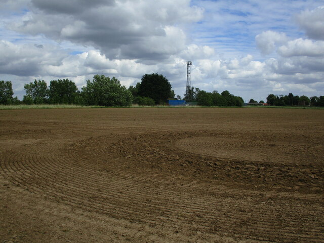
Quadring is a small village located in the South Holland district of Lincolnshire, England. Situated approximately 9 miles to the south of the town of Boston, Quadring is nestled in the picturesque Lincolnshire Fens. The village is surrounded by vast agricultural fields and features a charming rural landscape.

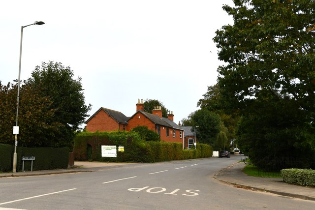
With a population of around 1,200 residents, Quadring maintains a close-knit community feel. The village is primarily residential, consisting of a mix of traditional brick and stone houses, as well as more modern developments. The village center is home to a few local amenities, including a post office, a village hall, and a primary school.

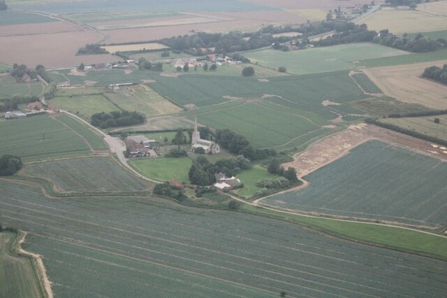
One of the notable landmarks in Quadring is St. Margaret's Church, which dates back to the 13th century. The church features an impressive bell tower and stained glass windows, reflecting the village's rich history. The nearby River Glen also adds to the scenic beauty of the area, providing opportunities for peaceful walks and fishing.

Quadring benefits from its proximity to Boston, which offers a wider range of amenities such as supermarkets, shops, and leisure facilities. The village is well-connected by road, with the A16 passing through nearby Boston, providing easy access to larger cities like Peterborough and Lincoln.

Overall, Quadring offers a tranquil and idyllic setting for those seeking a peaceful village life, while still being within reach of larger towns and cities. Its rural charm, community spirit, and beautiful surroundings make it a desirable place to live in Lincolnshire.

If you have any feedback on the listing, please let us know in the comments section below.

Quadring Images

Images are sourced within 2km of 52.881697/-0.181869 or Grid Reference TF2233. Thanks to Geograph Open Source API. All images are credited.

Church End, Quadring: aerial 2021
Road junction
Road junction
Quadring Road, Gosberton Looking towards Quadring.
Quadring Road, Gosberton
Looking towards Quadring.
The Bell Inn, Gosberton Dates from the early nineteenth century <span class="nowrap"><a title="https://historicengland.org.uk/listing/the-list/list-entry/1146579?section=official-list-entry" rel="nofollow ugc noopener" href="https://historicengland.org.uk/listing/the-list/list-entry/1146579?section=official-list-entry">Link</a><img style="margin-left:2px;" alt="External link" title="External link - shift click to open in new window" src="https://s1.geograph.org.uk/img/external.png" width="10" height="10"/></span>
The Bell Inn, Gosberton
Dates from the early nineteenth century LinkExternal link
Former shop, Gosberton
Church of St. Peter and St. Paul, Gosberton The spire dates from the fourteenth century <span class="nowrap"><a title="https://historicengland.org.uk/listing/the-list/list-entry/1064425?section=official-list-entry" rel="nofollow ugc noopener" href="https://historicengland.org.uk/listing/the-list/list-entry/1064425?section=official-list-entry">Link</a><img style="margin-left:2px;" alt="External link" title="External link - shift click to open in new window" src="https://s1.geograph.org.uk/img/external.png" width="10" height="10"/></span>
Church of St. Peter and St. Paul, Gosberton
The spire dates from the fourteenth century LinkExternal link
The Manor House, Gosberton
Houses on Bow Gate, Gosberton
Prepared field and communications mast near Quadring
Potato field, North Gate, Gosberton
Bull's Bank, Donington South Ing
Church End Drove crossing the Spalding to Sleaford line One of six level crossings in just over a mile of track!
Church End Drove crossing the Spalding to Sleaford line
One of six level crossings in just over a mile of track!
Quadring: Water Gate
Gosberton, St. Peter and St. Paul's Church: Northern aspect
Gosberton, St. Peter and St. Paul's Church: Tower and spire
Gosberton, St. Peter and St. Paul's Church: The churchyard and south entrance gate
Gosberton, St. Peter and St. Paul's Church: Southern aspect
Show me another place!

Quadring is located at Grid Ref: TF2233 (Lat: 52.881697, Lng: -0.181869)

Division: Parts of Holland

Administrative County: Lincolnshire

District: South Holland

Police Authority: Lincolnshire

What 3 Words

///preparing.explores.mount. Near Gosberton, Lincolnshire

Nearby Locations

Quadring

Related Wikis

Quadring

Quadring is a small village and civil parish in the South Holland district of Lincolnshire. It lies on the A152, 2 miles (3.2 km) north-east of Gosberton...

A152 road

The A152 is a small non-primary A-road in Lincolnshire, from Donington to Surfleet linking the A52 and the A16, two major primary routes. Between Donington...

Westhorpe, Lincolnshire

Westhorpe is a hamlet in the civil parish of Gosberton and the South Holland district of Lincolnshire, England. It is 30 miles (50 km) south-east from...

Quadring Eaudike

Quadring Eaudike is a hamlet in the South Holland district of Lincolnshire, England. It lies approximately 1 mile (2 km) east from the A152 road, and 2...

Donington, Lincolnshire

Donington is a large village and civil parish in the South Holland district of Lincolnshire, England. It is 8 miles (13 km) north from the market town...

Cowley Academy

Cowley Academy (formally The Thomas Cowley High School) is a mixed secondary school with Academy status, in Donington, Lincolnshire, England. As of 1 September...

Gosberton railway station

Gosberton railway station was a station in Gosberton, Lincolnshire. It was opened in 1882 and closed for passengers on 11 September 1961 and freight on...

Risegate

Risegate is a village in the civil parish of Gosberton and the South Holland district of Lincolnshire, England. It is 30 miles (50 km) south-east from...

Nearby Amenities

Located within 500m of 52.881697,-0.181869
Quadring
Is In: Lincolnshire, England, UK
Place: village
Source: Bing
Lat/Long: 52.8820823/-0.1836923
Bus Stop
182 Main Road
Bus: yes
Naptan AtcoCode: 270000009028
Naptan Bearing: SE
Naptan CommonName: 182 Main Road
Naptan Indicator: opp
Naptan Landmark: Number 182
Naptan NaptanCode: lingwpad
Naptan Street: Main Road
Naptan Verified: no
Public Transport: platform
Source: naptan_import
Lat/Long: 52.8844515/-0.1863062
Bus Stop
182 Main Road
Bus: yes
Naptan AtcoCode: 270000009029
Naptan Bearing: NW
Naptan CommonName: 182 Main Road
Naptan Indicator: adj
Naptan Landmark: Number 182
Naptan NaptanCode: lingwpag
Naptan Street: Main Road
Naptan Verified: no
Public Transport: platform
Source: naptan_import
Lat/Long: 52.8843619/-0.1863248
Bus Stop
St Margaret's
Bus: yes
Naptan AtcoCode: 270000009030
Naptan Bearing: SE
Naptan CommonName: St Margaret's
Naptan Indicator: adj
Naptan Landmark: St Margaret's
Naptan NaptanCode: lingwpaj
Naptan Street: Main Road
Naptan Verified: no
Public Transport: platform
Source: naptan_import
Lat/Long: 52.8802448/-0.1775647
Bus Stop
St Margaret's
Bus: yes
Naptan AtcoCode: 270000009031
Naptan Bearing: NW
Naptan CommonName: St Margaret's
Naptan Indicator: opp
Naptan Landmark: St Margaret's
Naptan NaptanCode: lingwpam
Naptan Street: Main Road
Naptan Verified: no
Public Transport: platform
Source: naptan_import
Lat/Long: 52.8803369/-0.1782891
Bus Stop
The White Hart Inn
Bus: yes
Naptan AtcoCode: 270000009902
Naptan Bearing: SW
Naptan CommonName: The White Hart Inn
Naptan Indicator: opp
Naptan Landmark: The White Hart Inn
Naptan NaptanCode: linjgdtp
Naptan Street: Town Drove
Naptan Verified: no
Public Transport: platform
Source: naptan_import
Lat/Long: 52.8815454/-0.182058
Bus Stop
Old Post Office
Bus: yes
Naptan AtcoCode: 2700LQP01414
Naptan Bearing: SE
Naptan CommonName: Old Post Office
Naptan Indicator: adj
Naptan Landmark: Old Post Office
Naptan NaptanCode: linajtpm
Naptan Street: Main Road
Naptan Verified: no
Public Transport: platform
Source: naptan_import
Lat/Long: 52.8815163/-0.181331
Bus Stop
Old Post Office
Bus: yes
Naptan AtcoCode: 2700LQRC1838
Naptan Bearing: NW
Naptan CommonName: Old Post Office
Naptan Indicator: opp
Naptan Landmark: Old Post Office
Naptan NaptanCode: linamtgt
Naptan Street: Main Road
Naptan Verified: no
Public Transport: platform
Source: naptan_import
Lat/Long: 52.8818249/-0.1821058
Manor House Farm
Place: farm
Source: Bing
Lat/Long: 52.8829759/-0.1848037
Turning Circle
Lat/Long: 52.88472/-0.1771478
Post Office
Quadring Post Office
Addr City: Spalding
Addr Country: GB
Addr Housenumber: 105
Addr Postcode: PE11 4PW
Addr Street: Main Road
Addr Suburb: Quadring
Brand: Post Office
Brand Wikidata: Q1783168
Fhrs Authority: South Holland
Fhrs Id: 243291
Fhrs Local Authority Id: 2536
Ref Pol Id: 10167
Website: https://www.postoffice.co.uk/branch-finder/2572303/quadring
Lat/Long: 52.8816693/-0.1815909
Pub
White Hart
Addr City: Spalding
Addr Country: GB
Addr Housenumber: 7
Addr Postcode: PE11 4PU
Addr Street: Town Drove
Addr Suburb: Quadring
Beer Garden: yes
Fhrs Authority: South Holland
Fhrs Id: 243556
Fhrs Local Authority Id: 13012
Outdoor Seating: yes
Lat/Long: 52.8813424/-0.1828891
Restaurant
Curry Inn
Addr City: Spalding
Addr Country: GB
Addr Housenumber: 128
Addr Postcode: PE11 4PW
Addr Street: Main Road
Addr Suburb: Quadring
Cuisine: indian
Fhrs Authority: South Holland
Fhrs Id: 243180
Fhrs Local Authority Id: 27590
Lat/Long: 52.8817244/-0.1821703
Generator Method: photovoltaic
Generator Output Electricity: yes
Generator Source: solar
Generator Type: solar_photovoltaic_panel
Location: roof
Power: generator
Lat/Long: 52.882385/-0.1853058
Generator Method: photovoltaic
Generator Output Electricity: yes
Generator Source: solar
Generator Type: solar_photovoltaic_panel
Location: roof
Power: generator
Lat/Long: 52.882283/-0.1856598
Generator Method: photovoltaic
Generator Output Electricity: yes
Generator Source: solar
Generator Type: solar_photovoltaic_panel
Location: roof
Power: generator
Lat/Long: 52.8817586/-0.1845172
Generator Method: photovoltaic
Generator Output Electricity: yes
Generator Source: solar
Generator Type: solar_photovoltaic_panel
Location: roof
Power: generator
Lat/Long: 52.8813653/-0.1851556
Generator Method: photovoltaic
Generator Output Electricity: yes
Generator Source: solar
Generator Type: solar_photovoltaic_panel
Location: roof
Power: generator
Lat/Long: 52.8817214/-0.1878726
Generator Method: photovoltaic
Generator Output Electricity: yes
Generator Source: solar
Generator Type: solar_photovoltaic_panel
Location: roof
Power: generator
Lat/Long: 52.880386/-0.1844823
Generator Method: photovoltaic
Generator Output Electricity: yes
Generator Source: solar
Generator Type: solar_photovoltaic_panel
Location: roof
Power: generator
Lat/Long: 52.8792918/-0.1850832
Generator Method: photovoltaic
Generator Output Electricity: yes
Generator Source: solar
Generator Type: solar_photovoltaic_panel
Location: roof
Power: generator
Lat/Long: 52.8790765/-0.1842865
Generator Method: photovoltaic
Generator Output Electricity: yes
Generator Source: solar
Generator Type: solar_photovoltaic_panel
Location: roof
Power: generator
Lat/Long: 52.8790716/-0.1845682
Generator Method: photovoltaic
Generator Output Electricity: yes
Generator Source: solar
Generator Type: solar_photovoltaic_panel
Location: roof
Power: generator
Lat/Long: 52.879015/-0.184536
Generator Method: photovoltaic
Generator Output Electricity: yes
Generator Source: solar
Generator Type: solar_photovoltaic_panel
Location: roof
Power: generator
Lat/Long: 52.8790157/-0.1862226
Generator Method: photovoltaic
Generator Output Electricity: yes
Generator Source: solar
Generator Type: solar_photovoltaic_panel
Location: roof
Power: generator
Lat/Long: 52.8793871/-0.1856692
Generator Method: photovoltaic
Generator Output Electricity: yes
Generator Source: solar
Generator Type: solar_photovoltaic_panel
Location: roof
Power: generator
Lat/Long: 52.8799488/-0.1851837
Generator Method: photovoltaic
Generator Output Electricity: yes
Generator Source: solar
Generator Type: solar_photovoltaic_panel
Location: roof
Power: generator
Lat/Long: 52.8800022/-0.1860581
Generator Method: photovoltaic
Generator Output Electricity: yes
Generator Source: solar
Generator Type: solar_photovoltaic_panel
Location: roof
Power: generator
Lat/Long: 52.8814849/-0.1840089
Generator Method: photovoltaic
Generator Output Electricity: yes
Generator Source: solar
Generator Type: solar_photovoltaic_panel
Location: roof
Power: generator
Lat/Long: 52.8843109/-0.1759703
Generator Method: photovoltaic
Generator Output Electricity: yes
Generator Source: solar
Generator Type: solar_photovoltaic_panel
Location: roof
Power: generator
Lat/Long: 52.8841645/-0.1759757
Generator Method: photovoltaic
Generator Output Electricity: yes
Generator Source: solar
Generator Type: solar_photovoltaic_panel
Location: roof
Power: generator
Lat/Long: 52.8841782/-0.1759838
Direction: WSW
Generator Method: photovoltaic
Generator Output Electricity: yes
Generator Solar Modules: 8
Generator Source: solar
Generator Type: solar_photovoltaic_panel
Location: roof
Power: generator
Lat/Long: 52.880427/-0.1775891
Direction: SSE
Generator Method: photovoltaic
Generator Output Electricity: yes
Generator Solar Modules: 6
Generator Source: solar
Generator Type: solar_photovoltaic_panel
Location: roof
Power: generator
Lat/Long: 52.8804108/-0.1775274
Direction: SSW
Generator Method: photovoltaic
Generator Output Electricity: yes
Generator Solar Modules: 14
Generator Source: solar
Generator Type: solar_photovoltaic_panel
Location: roof
Power: generator
Lat/Long: 52.8800159/-0.1763311
Direction: SSW
Generator Method: photovoltaic
Generator Output Electricity: yes
Generator Source: solar
Generator Type: solar_photovoltaic_panel
Location: roof
Power: generator
Lat/Long: 52.8796193/-0.1767871
Direction: SE
Generator Method: photovoltaic
Generator Output Electricity: yes
Generator Solar Modules: 16
Generator Source: solar
Generator Type: solar_photovoltaic_panel
Location: roof
Power: generator
Lat/Long: 52.8818513/-0.1825096
Generator Method: photovoltaic
Generator Output Electricity: yes
Generator Source: solar
Generator Type: solar_photovoltaic_panel
Location: roof
Power: generator
Lat/Long: 52.8812661/-0.1881167
Direction: SSW
Generator Method: photovoltaic
Generator Output Electricity: yes
Generator Solar Modules: 6
Generator Source: solar
Generator Type: solar_photovoltaic_panel
Location: roof
Power: generator
Lat/Long: 52.8807181/-0.1787001
Direction: ESE
Generator Method: photovoltaic
Generator Output Electricity: yes
Generator Solar Modules: 4
Generator Source: solar
Generator Type: solar_photovoltaic_panel
Location: roof
Power: generator
Lat/Long: 52.880731/-0.1786424
The data included in this document is from www.openstreetmap.org. The data is made available under ODbL.

Have you been to Quadring?

Leave your review of Quadring below (or comments, questions and feedback).