Pytchley

Settlement in Northamptonshire

England

Pytchley

Bus shelter, Pytchley The stone built bus shelter blends well with the surrounding buildings.  The Church of All Saints is in the adjoining grid square.
Bus shelter, Pytchley Credit: Maigheach-gheal

Pytchley is a small village located in the county of Northamptonshire, England. Situated approximately 9 miles northeast of Northampton, it falls under the administrative district of Kettering. The village is set amidst the picturesque countryside, surrounded by rolling hills and open fields.

Pytchley is renowned for its rich history, dating back to the Anglo-Saxon era. The village is mentioned in the Domesday Book of 1086, and its name is believed to be derived from the Old English words "pict" and "leah," meaning "wood or clearing of the Picts."

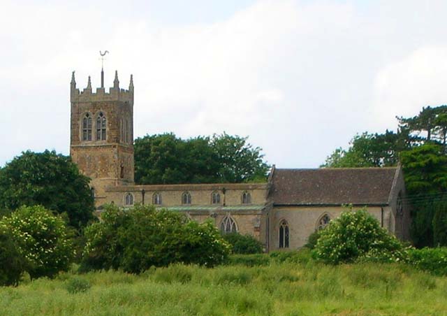
The heart of Pytchley is centered around the village green, a charming open space that has served as a meeting point for locals for centuries. The green is home to a number of historic buildings, including the 15th-century Church of St. John the Baptist, known for its beautiful stained glass windows and intricate architecture.

The village also boasts a strong equestrian tradition, being the birthplace of the Pytchley Hunt. Established in 1750, it is one of the oldest and most prestigious hunts in England. The surrounding countryside provides excellent opportunities for horse riding and exploring scenic bridleways.

Despite its small size, Pytchley offers various amenities to its residents and visitors. These include a local pub, a primary school, and a village hall that hosts community events and gatherings.

Overall, Pytchley is a quintessential English village, cherished for its tranquil surroundings, rich heritage, and strong sense of community.

If you have any feedback on the listing, please let us know in the comments section below.

Pytchley Images

Images are sourced within 2km of 52.363769/-0.739186 or Grid Reference SP8574. Thanks to Geograph Open Source API. All images are credited.

Bus shelter, Pytchley The stone built bus shelter blends well with the surrounding buildings.  The Church of All Saints is in the adjoining grid square.
Bus shelter, Pytchley
The stone built bus shelter blends well with the surrounding buildings. The Church of All Saints is in the adjoining grid square.
The Church of All Saints, Pytchley The church has its origins in the 12th century with periods of restoration being carried out in 1861 and 1903.  It is built of coursed and squared stone and ashlar.
The Church of All Saints, Pytchley
The church has its origins in the 12th century with periods of restoration being carried out in 1861 and 1903. It is built of coursed and squared stone and ashlar.
Bench Mark, All Saints Church The bench mark is to be found on the south face of the church porch.  For a view of the church <a href="https://www.geograph.org.uk/photo/2369151">SP8674 : The Church of All Saints, Pytchley</a> and for further information on the bench mark and others in the area <span class="nowrap"><a title="http://www.bench-marks.org.uk/bm37621" rel="nofollow ugc noopener" href="http://www.bench-marks.org.uk/bm37621">Link</a><img style="margin-left:2px;" alt="External link" title="External link - shift click to open in new window" src="https://s1.geograph.org.uk/img/external.png" width="10" height="10"/></span>
Bench Mark, All Saints Church
The bench mark is to be found on the south face of the church porch. For a view of the church SP8674 : The Church of All Saints, Pytchley and for further information on the bench mark and others in the area LinkExternal link
Door, All Saints Church The plank door and hinges date from the 16th century.  For a wider view of the church <a href="https://www.geograph.org.uk/photo/2369151">SP8674 : The Church of All Saints, Pytchley</a>
Door, All Saints Church
The plank door and hinges date from the 16th century. For a wider view of the church SP8674 : The Church of All Saints, Pytchley
Detail to door, All Saints Church The handles and keyhole to the 16th century door to the church.  For a wider view of the door <a href="https://www.geograph.org.uk/photo/2369243">SP8674 : Door, All Saints Church</a>
Detail to door, All Saints Church
The handles and keyhole to the 16th century door to the church. For a wider view of the door SP8674 : Door, All Saints Church
Postbox, Pytchley The George VI reign (1936-52) postbox is to be found set into the wall of a house near the church.
Postbox, Pytchley
The George VI reign (1936-52) postbox is to be found set into the wall of a house near the church.
Footpath near Pytchley The footpath, which initially passes beside a small area of woodland, takes walkers from Broughton Road back to the village of Pytchley.
Footpath near Pytchley
The footpath, which initially passes beside a small area of woodland, takes walkers from Broughton Road back to the village of Pytchley.
Bridleway near Pytchley The bridleway passes between high hedges as it takes riders and walkers from the Broughton Road towards the A43.
Bridleway near Pytchley
The bridleway passes between high hedges as it takes riders and walkers from the Broughton Road towards the A43.
Cart shed near Broughton This beautifully built cart shed is part of Spencer Lodge.  The building stands beside the Broughton Road.
Cart shed near Broughton
This beautifully built cart shed is part of Spencer Lodge. The building stands beside the Broughton Road.
Orlingbury Road A rainy day in Pytchley.
Orlingbury Road
A rainy day in Pytchley.
Car park and entrance to Tesco store on Kettering Retail Park
A14 - A509 junction's bridges A classic UK roundabout junction.
A14 - A509 junction's bridges
A classic UK roundabout junction.
A14 passing Kettering Services HGVs rejoining the eastbound A14 via the sliproad from the Kettering service area.
A14 passing Kettering Services
HGVs rejoining the eastbound A14 via the sliproad from the Kettering service area.
Eastbound A14, Junction 9 (for A509) The A14 is a major road which runs for 129 miles from the Port of Felixstowe to the Catthorpe Interchange, the junction of the M1 and M6 motorways near Rugby.

The route linking Rugby (and therefore the West Midlands and the north of England via the motorway network) to East Anglia and the ports of Felixstowe and Harwich is incredibly important and incredibly busy (Felixstowe is the UK's principal container port and the A14 is the road between Felixstowe and everywhere else) but it didn't exist in any coherent form until about 1992.

Prior to the current A14 the main route from Birmingham to the Haven ports followed the old A45 road via Coventry, Rugby, Northampton, St Neots, Cambridge and then through all the towns on the A14, from there to Ipswich where it ended on the A12 – not the fast route required for transporting goods across the country with the sudden rise in container shipping during the latter part of the twentieth century.

Most of the current A14 route is a collection of bits of dual carriageway acquired from other roads (most notably the A45) with occasional stretches of new road to bolt it all together. Because of its importance to the country’s economy, there are plans to upgrade it further.

Prior to its use for the current route the A14 designation had been used for a section of road between the A10 at Royston and the A1 at Alconbury following part of the route of the Roman road, Ermine Street, which is now mostly designated as the A1198. The only bit of the current A14 that follows that number's original route is the spur linking junction 23 to the A1.

<span class="nowrap"><a title="http://www.cbrd.co.uk/motorway/a14" rel="nofollow ugc noopener" href="http://www.cbrd.co.uk/motorway/a14">Link</a><img style="margin-left:2px;" alt="External link" title="External link - shift click to open in new window" src="https://s1.geograph.org.uk/img/external.png" width="10" height="10"/></span> Chris's British Road Directory
<span class="nowrap"><a title="http://en.wikipedia.org/wiki/A14_road_(England)" rel="nofollow ugc noopener" href="http://en.wikipedia.org/wiki/A14_road_(England)">Link</a><img style="margin-left:2px;" alt="External link" title="External link - shift click to open in new window" src="https://s1.geograph.org.uk/img/external.png" width="10" height="10"/></span>  Wikipedia
Eastbound A14, Junction 9 (for A509)
The A14 is a major road which runs for 129 miles from the Port of Felixstowe to the Catthorpe Interchange, the junction of the M1 and M6 motorways near Rugby. The route linking Rugby (and therefore the West Midlands and the north of England via the motorway network) to East Anglia and the ports of Felixstowe and Harwich is incredibly important and incredibly busy (Felixstowe is the UK's principal container port and the A14 is the road between Felixstowe and everywhere else) but it didn't exist in any coherent form until about 1992. Prior to the current A14 the main route from Birmingham to the Haven ports followed the old A45 road via Coventry, Rugby, Northampton, St Neots, Cambridge and then through all the towns on the A14, from there to Ipswich where it ended on the A12 – not the fast route required for transporting goods across the country with the sudden rise in container shipping during the latter part of the twentieth century. Most of the current A14 route is a collection of bits of dual carriageway acquired from other roads (most notably the A45) with occasional stretches of new road to bolt it all together. Because of its importance to the country’s economy, there are plans to upgrade it further. Prior to its use for the current route the A14 designation had been used for a section of road between the A10 at Royston and the A1 at Alconbury following part of the route of the Roman road, Ermine Street, which is now mostly designated as the A1198. The only bit of the current A14 that follows that number's original route is the spur linking junction 23 to the A1. LinkExternal link Chris's British Road Directory LinkExternal link Wikipedia
Eastbound A14, Bridges at Junction 9 The A14 is a major road which runs for 129 miles from the Port of Felixstowe to the Catthorpe Interchange, the junction of the M1 and M6 motorways near Rugby.

The route linking Rugby (and therefore the West Midlands and the north of England via the motorway network) to East Anglia and the ports of Felixstowe and Harwich is incredibly important and incredibly busy (Felixstowe is the UK's principal container port and the A14 is the road between Felixstowe and everywhere else) but it didn't exist in any coherent form until about 1992.

Prior to the current A14 the main route from Birmingham to the Haven ports followed the old A45 road via Coventry, Rugby, Northampton, St Neots, Cambridge and then through all the towns on the A14, from there to Ipswich where it ended on the A12 – not the fast route required for transporting goods across the country with the sudden rise in container shipping during the latter part of the twentieth century.

Most of the current A14 route is a collection of bits of dual carriageway acquired from other roads (most notably the A45) with occasional stretches of new road to bolt it all together. Because of its importance to the country’s economy, there are plans to upgrade it further.

Prior to its use for the current route the A14 designation had been used for a section of road between the A10 at Royston and the A1 at Alconbury following part of the route of the Roman road, Ermine Street, which is now mostly designated as the A1198. The only bit of the current A14 that follows that number's original route is the spur linking junction 23 to the A1.

<span class="nowrap"><a title="http://www.cbrd.co.uk/motorway/a14" rel="nofollow ugc noopener" href="http://www.cbrd.co.uk/motorway/a14">Link</a><img style="margin-left:2px;" alt="External link" title="External link - shift click to open in new window" src="https://s1.geograph.org.uk/img/external.png" width="10" height="10"/></span> Chris's British Road Directory
<span class="nowrap"><a title="http://en.wikipedia.org/wiki/A14_road_(England)" rel="nofollow ugc noopener" href="http://en.wikipedia.org/wiki/A14_road_(England)">Link</a><img style="margin-left:2px;" alt="External link" title="External link - shift click to open in new window" src="https://s1.geograph.org.uk/img/external.png" width="10" height="10"/></span>  Wikipedia
Eastbound A14, Bridges at Junction 9
The A14 is a major road which runs for 129 miles from the Port of Felixstowe to the Catthorpe Interchange, the junction of the M1 and M6 motorways near Rugby. The route linking Rugby (and therefore the West Midlands and the north of England via the motorway network) to East Anglia and the ports of Felixstowe and Harwich is incredibly important and incredibly busy (Felixstowe is the UK's principal container port and the A14 is the road between Felixstowe and everywhere else) but it didn't exist in any coherent form until about 1992. Prior to the current A14 the main route from Birmingham to the Haven ports followed the old A45 road via Coventry, Rugby, Northampton, St Neots, Cambridge and then through all the towns on the A14, from there to Ipswich where it ended on the A12 – not the fast route required for transporting goods across the country with the sudden rise in container shipping during the latter part of the twentieth century. Most of the current A14 route is a collection of bits of dual carriageway acquired from other roads (most notably the A45) with occasional stretches of new road to bolt it all together. Because of its importance to the country’s economy, there are plans to upgrade it further. Prior to its use for the current route the A14 designation had been used for a section of road between the A10 at Royston and the A1 at Alconbury following part of the route of the Roman road, Ermine Street, which is now mostly designated as the A1198. The only bit of the current A14 that follows that number's original route is the spur linking junction 23 to the A1. LinkExternal link Chris's British Road Directory LinkExternal link Wikipedia
Westbound A14 approaching Kettering Services The A14 is a major road which runs for 129 miles from the Port of Felixstowe to the Catthorpe Interchange, the junction of the M1 and M6 motorways near Rugby.

The route linking Rugby (and therefore the West Midlands and the north of England via the motorway network) to East Anglia and the ports of Felixstowe and Harwich is incredibly important and incredibly busy (Felixstowe is the UK's principal container port and the A14 is the road between Felixstowe and everywhere else) but it didn't exist in any coherent form until about 1992.

Prior to the current A14 the main route from Birmingham to the Haven ports followed the old A45 road via Coventry, Rugby, Northampton, St Neots, Cambridge and then through all the towns on the A14, from there to Ipswich where it ended on the A12 – not the fast route required for transporting goods across the country with the sudden rise in container shipping during the latter part of the twentieth century.

Most of the current A14 route is a collection of bits of dual carriageway acquired from other roads (most notably the A45) with occasional stretches of new road to bolt it all together. Because of its importance to the country’s economy, there are plans to upgrade it further.

Prior to its use for the current route the A14 designation had been used for a section of road between the A10 at Royston and the A1 at Alconbury following part of the route of the Roman road, Ermine Street, which is now mostly designated as the A1198. The only bit of the current A14 that follows that number's original route is the spur linking junction 23 to the A1.

<span class="nowrap"><a title="http://www.cbrd.co.uk/motorway/a14" rel="nofollow ugc noopener" href="http://www.cbrd.co.uk/motorway/a14">Link</a><img style="margin-left:2px;" alt="External link" title="External link - shift click to open in new window" src="https://s1.geograph.org.uk/img/external.png" width="10" height="10"/></span> Chris's British Road Directory
<span class="nowrap"><a title="http://en.wikipedia.org/wiki/A14_road_(England)" rel="nofollow ugc noopener" href="http://en.wikipedia.org/wiki/A14_road_(England)">Link</a><img style="margin-left:2px;" alt="External link" title="External link - shift click to open in new window" src="https://s1.geograph.org.uk/img/external.png" width="10" height="10"/></span>  Wikipedia
Westbound A14 approaching Kettering Services
The A14 is a major road which runs for 129 miles from the Port of Felixstowe to the Catthorpe Interchange, the junction of the M1 and M6 motorways near Rugby. The route linking Rugby (and therefore the West Midlands and the north of England via the motorway network) to East Anglia and the ports of Felixstowe and Harwich is incredibly important and incredibly busy (Felixstowe is the UK's principal container port and the A14 is the road between Felixstowe and everywhere else) but it didn't exist in any coherent form until about 1992. Prior to the current A14 the main route from Birmingham to the Haven ports followed the old A45 road via Coventry, Rugby, Northampton, St Neots, Cambridge and then through all the towns on the A14, from there to Ipswich where it ended on the A12 – not the fast route required for transporting goods across the country with the sudden rise in container shipping during the latter part of the twentieth century. Most of the current A14 route is a collection of bits of dual carriageway acquired from other roads (most notably the A45) with occasional stretches of new road to bolt it all together. Because of its importance to the country’s economy, there are plans to upgrade it further. Prior to its use for the current route the A14 designation had been used for a section of road between the A10 at Royston and the A1 at Alconbury following part of the route of the Roman road, Ermine Street, which is now mostly designated as the A1198. The only bit of the current A14 that follows that number's original route is the spur linking junction 23 to the A1. LinkExternal link Chris's British Road Directory LinkExternal link Wikipedia
A509 crossing the A14
A509 approaching Kettering But first the shopping parks.
A509 approaching Kettering
But first the shopping parks.
Show me another place!

Pytchley is located at Grid Ref: SP8574 (Lat: 52.363769, Lng: -0.739186)

Unitary Authority: North Northamptonshire

Police Authority: Northamptonshire

What 3 Words

///tries.lawns.walks. Near Broughton, Northamptonshire

Related Wikis

Pytchley

Pytchley is a village and civil parish in Northamptonshire, England, three miles south-west of Kettering and near the A14 road. At the time of the 2011...

Broughton, Northamptonshire

Broughton is a large village and civil parish in North Northamptonshire, England. The village is around 2 miles (3.2 km) south-west of Kettering and is...

Bishop Stopford School

Bishop Stopford School is a secondary school and sixth form with academy status in Kettering, Northamptonshire, England.The school is located in the Headlands...

Kettering Conference Centre

The Kettering Conference Centre was a multi-functional sports and conference centre located in Kettering, Northamptonshire. It was also the location of...

Nearby Amenities

Located within 500m of 52.363769,-0.739186
Pytchley
Is In: Kettering District
Note: Northamptonshire,England,UK
Place: village
Lat/Long: 52.363594/-0.739943
Barrier: stile
Lat/Long: 52.3631474/-0.7462972
Barrier: stile
Lat/Long: 52.3640433/-0.7452055
Power: pole
Lat/Long: 52.3652772/-0.7406491
Power: pole
Lat/Long: 52.3654754/-0.7415503
Power: pole
Lat/Long: 52.3656309/-0.7425562
Post Box
Collection Times: Mo-Fr 09:00; Sa 07:00
Operator: Royal Mail
Post Box Type: lamp
Ref: NN14 817D
Royal Cypher: EIIR
Royal Cypher Wikidata: Q33102113
Source: survey
Lat/Long: 52.3601961/-0.7391391
Entrance: yes
Lat/Long: 52.3634166/-0.7387635
Entrance: yes
Lat/Long: 52.3635487/-0.7386784
Post Box
Brand: Royal Mail
Brand Wikidata: Q638098
Brand Wikipedia: en:Royal Mail
Operator: Royal Mail
Operator Wikidata: Q638098
Post Box Type: wall
Ref: NN14 80
Lat/Long: 52.363697/-0.7394153
Bus Stop
Lower End (near)
Bin: yes
Naptan AtcoCode: 300000434LO
Naptan CommonName: Lower End
Naptan Indicator: near
Naptan Landmark: Bus Shelter
Naptan NaptanCode: nthawmgj
Naptan Street: Orlingbury Road
Public Transport: platform
Shelter: yes
Lat/Long: 52.3612876/-0.7393781
Bus Stop
Lower End (adj)
Naptan AtcoCode: 300000434LG
Naptan CommonName: Lower End
Naptan Indicator: adj
Naptan Landmark: Lower End
Naptan NaptanCode: nthawmgd
Naptan Street: Orlingbury Road
Public Transport: platform
Lat/Long: 52.3616991/-0.7389902
Bus Stop
All Saints Church (o/s)
Bench: no
Bin: yes
Naptan AtcoCode: 300000434CH
Naptan CommonName: All Saints Church
Naptan Indicator: o/s
Naptan Landmark: All Saints Church
Naptan NaptanCode: nthawmga
Naptan Street: Isham Road
Public Transport: platform
Shelter: yes
Lat/Long: 52.3639997/-0.7386982
Barrier: yes
Lat/Long: 52.3645273/-0.7415796
The data included in this document is from www.openstreetmap.org. The data is made available under ODbL.

Have you been to Pytchley?

Leave your review of Pytchley below (or comments, questions and feedback).