Bishton

Settlement in Staffordshire Stafford

England

Bishton

Ford at the Wolseley Centre Footbridges are available nearby. The Wolseley Centre is the HQ of the Staffordshire Wildlife Trust, with extensive grounds, two lakes and a cafe and gift shop.
Ford at the Wolseley Centre Credit: Christine Johnstone

Bishton is a small village located in the county of Staffordshire, England. Situated approximately 6 miles northeast of the town of Stafford, Bishton is nestled within the rural countryside, offering residents and visitors a peaceful and picturesque setting.

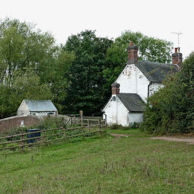
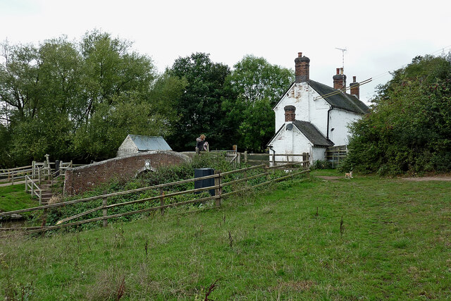
With a population of around 200 people, the village exudes a close-knit community spirit. Bishton is renowned for its quaint and traditional charm, with most of the buildings constructed in the characteristic Staffordshire red brick. The village is home to a variety of architectural styles, including Tudor, Georgian, and Victorian, showcasing its rich historical heritage.

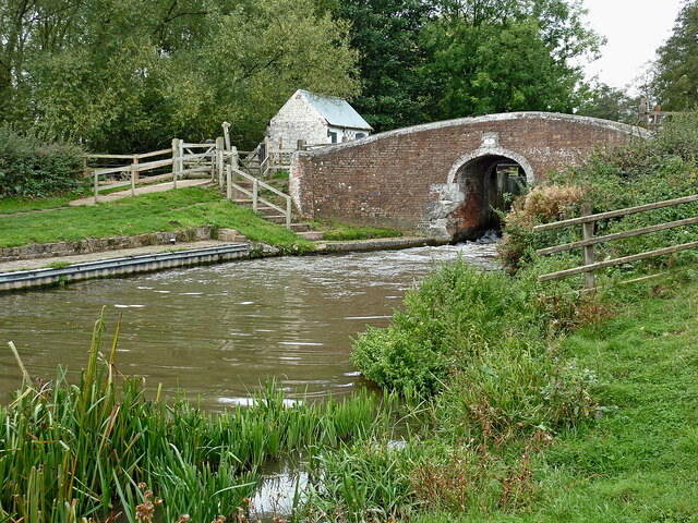
Surrounded by lush green fields and rolling hills, Bishton is an ideal destination for nature enthusiasts. The area offers numerous walking and cycling routes, allowing visitors to explore the stunning Staffordshire countryside. Additionally, the nearby River Trent provides opportunities for fishing and boating activities.

One of the notable landmarks in Bishton is the St. Lawrence Church, a Grade II listed building. Dating back to the 12th century, this charming church features intricate stained glass windows and a peaceful churchyard. The village also boasts a village hall, which serves as a hub for social and community activities.

While Bishton offers a tranquil rural lifestyle, it benefits from its proximity to larger towns and cities. The nearby town of Stafford provides a range of amenities, including shops, supermarkets, schools, and healthcare facilities. Furthermore, Bishton enjoys good transportation links, with easy access to major road networks such as the A518 and A51, allowing for convenient travel to neighboring areas.

Overall, Bishton is a delightful village that embraces its idyllic countryside setting while offering convenient access to essential amenities and neighboring towns.

If you have any feedback on the listing, please let us know in the comments section below.

Bishton Images

Images are sourced within 2km of 52.7843/-1.966607 or Grid Reference SK0220. Thanks to Geograph Open Source API. All images are credited.

Ford at the Wolseley Centre Footbridges are available nearby. The Wolseley Centre is the HQ of the Staffordshire Wildlife Trust, with extensive grounds, two lakes and a cafe and gift shop.
Ford at the Wolseley Centre
Footbridges are available nearby. The Wolseley Centre is the HQ of the Staffordshire Wildlife Trust, with extensive grounds, two lakes and a cafe and gift shop.
Swan Lake, the Wolseley Centre Despite the name of the lake, it's Canada geese that are flying in. The Wolseley Centre is the HQ of the Staffordshire Wildlife Trust, with extensive grounds, two lakes and a cafe and gift shop.
Swan Lake, the Wolseley Centre
Despite the name of the lake, it's Canada geese that are flying in. The Wolseley Centre is the HQ of the Staffordshire Wildlife Trust, with extensive grounds, two lakes and a cafe and gift shop.
Path in the 'Wet Meadow', the Wolseley Centre The Wolseley Centre is the HQ of the Staffordshire Wildlife Trust, with extensive grounds, two lakes, a cafe and a gift shop.
Path in the 'Wet Meadow', the Wolseley Centre
The Wolseley Centre is the HQ of the Staffordshire Wildlife Trust, with extensive grounds, two lakes, a cafe and a gift shop.
Footbridge at the Wolseley Centre Funded by a Rotary Club. The Wolseley Centre is the HQ of the Staffordshire Wildlife Trust, with extensive grounds, two lakes, a cafe and a gift shop.
Footbridge at the Wolseley Centre
Funded by a Rotary Club. The Wolseley Centre is the HQ of the Staffordshire Wildlife Trust, with extensive grounds, two lakes, a cafe and a gift shop.
Canada geese on Swan Lake, the Wolseley Centre The Wolseley Centre is the HQ of the Staffordshire Wildlife Trust, with extensive grounds, two lakes, a cafe and a gift shop.
Canada geese on Swan Lake, the Wolseley Centre
The Wolseley Centre is the HQ of the Staffordshire Wildlife Trust, with extensive grounds, two lakes, a cafe and a gift shop.
The fernery at the Wolseley Centre A plaque reads 'Planted in memory of Margaret Kingston (1934 - 2011) from dionations given to Friends of Cannock Chase in her memory'. The Wolseley Centre is the HQ of the Staffordshire Wildlife Trust, with extensive grounds, two lakes, a cafe and a gift shop.
The fernery at the Wolseley Centre
A plaque reads 'Planted in memory of Margaret Kingston (1934 - 2011) from dionations given to Friends of Cannock Chase in her memory'. The Wolseley Centre is the HQ of the Staffordshire Wildlife Trust, with extensive grounds, two lakes, a cafe and a gift shop.
Spider's web artwork at the Wolseley Centre The Wolseley Centre is the HQ of the Staffordshire Wildlife Trust, with extensive grounds, two lakes, a cafe and a gift shop.
Spider's web artwork at the Wolseley Centre
The Wolseley Centre is the HQ of the Staffordshire Wildlife Trust, with extensive grounds, two lakes, a cafe and a gift shop.
Half-buried structure at the Wolseley Centre Possibly the remains of an ice house? The Wolseley Centre is the HQ of the Staffordshire Wildlife Trust, with extensive grounds, two lakes, a cafe and a gift shop.
Half-buried structure at the Wolseley Centre
Possibly the remains of an ice house? The Wolseley Centre is the HQ of the Staffordshire Wildlife Trust, with extensive grounds, two lakes, a cafe and a gift shop.
Cottage by Colwich Lock in Staffordshire Colwich Lock (No 21) is on the Trent and Mersey Canal near Little Haywood. A public footpath crosses the bridge here.
Cottage by Colwich Lock in Staffordshire
Colwich Lock (No 21) is on the Trent and Mersey Canal near Little Haywood. A public footpath crosses the bridge here.
Cottage and canal bridge near Colwich in Staffordshire Colwich Lock (No 21) is on the Trent and Mersey Canal near Little Haywood. A public footpath crosses the bridge here.
Cottage and canal bridge near Colwich in Staffordshire
Colwich Lock (No 21) is on the Trent and Mersey Canal near Little Haywood. A public footpath crosses the bridge here.
Colwich Bridge near Little Haywood in Staffordshire Bridge No 72 across the Trent and Mersey Canal is immediately below Colwich Lock.
Notice the turbulence in the water below the bridge. The lock paddles have bee raised, and water is gushing through. A narrowboat will emerge very soon.

<a href="https://www.geograph.org.uk/photo/2662653">SK0021 : Colwich Bridge near Little Haywood in Staffordshire</a>

The Trent and Mersey Canal is 93.5 miles in length from Derwent Mouth to Preston Brook. The first sod was cut by Josiah Wedgwood in July 1766 at Middleport (Stoke-on-Trent). The eastern section between Derwent Mouth and Shugborough (the junction with the Staffordshire and Worcestershire Canal) was already operational by 1770 and the whole canal through to Preston Brook, where it linked with the Bridgewater Canal was open for business by 1777. James Brindley was the engineer until his death in 1772.
Colwich Bridge near Little Haywood in Staffordshire
Bridge No 72 across the Trent and Mersey Canal is immediately below Colwich Lock. Notice the turbulence in the water below the bridge. The lock paddles have bee raised, and water is gushing through. A narrowboat will emerge very soon. SK0021 : Colwich Bridge near Little Haywood in Staffordshire The Trent and Mersey Canal is 93.5 miles in length from Derwent Mouth to Preston Brook. The first sod was cut by Josiah Wedgwood in July 1766 at Middleport (Stoke-on-Trent). The eastern section between Derwent Mouth and Shugborough (the junction with the Staffordshire and Worcestershire Canal) was already operational by 1770 and the whole canal through to Preston Brook, where it linked with the Bridgewater Canal was open for business by 1777. James Brindley was the engineer until his death in 1772.
Canal south-east of Colwich in Staffordshire This is the Trent and Mersey Canal approaching Wolseley Bridge, No 70.
Canal south-east of Colwich in Staffordshire
This is the Trent and Mersey Canal approaching Wolseley Bridge, No 70.
Canal south-east of Colwich in Staffordshire This is the Trent and Mersey Canal approaching Wolseley Bridge, No 70.
Canal south-east of Colwich in Staffordshire
This is the Trent and Mersey Canal approaching Wolseley Bridge, No 70.
Wolseley Bridge near Colwich in Staffordshire Wolseley Bridge is No 70 across the Trent and Mersey Canal. It carries the A51 between Stone and Rugeley.
Wolseley Bridge near Colwich in Staffordshire
Wolseley Bridge is No 70 across the Trent and Mersey Canal. It carries the A51 between Stone and Rugeley.
Trent and Mersey Canal near Colwich, Staffordshire Looking east on a dull morning from near Wolseley Bridge as the canal meanders towards Rugeley.
Trent and Mersey Canal near Colwich, Staffordshire
Looking east on a dull morning from near Wolseley Bridge as the canal meanders towards Rugeley.
Moored narrowboats near Colwich in Staffordshire This is the Trent and Mersey Canal on a dull morning north-west of Wolseley Bridge, between Great Haywood and Rugeley.
Moored narrowboats near Colwich in Staffordshire
This is the Trent and Mersey Canal on a dull morning north-west of Wolseley Bridge, between Great Haywood and Rugeley.
Moored narrowboats near Colwich in Staffordshire This is the Trent and Mersey Canal north-west of Wolseley Bridge, between Great Haywood and Rugeley.
Moored narrowboats near Colwich in Staffordshire
This is the Trent and Mersey Canal north-west of Wolseley Bridge, between Great Haywood and Rugeley.
London Road near Little Haywood, Staffordshire This is the A51 London Road, looking south-east towards the A513 junction, and Rugeley. The bridge ahead crosses the River Trent.
London Road near Little Haywood, Staffordshire
This is the A51 London Road, looking south-east towards the A513 junction, and Rugeley. The bridge ahead crosses the River Trent.
Show me another place!

Bishton is located at Grid Ref: SK0220 (Lat: 52.7843, Lng: -1.966607)

Administrative County: Staffordshire

District: Stafford

Police Authority: Staffordshire

What 3 Words

///steers.apple.lifestyle. Near Colwich, Staffordshire

Related Wikis

Wolseley Hall

Wolseley Hall was a stately home near the village of Colwich, in Staffordshire, England. It was demolished in 1966; the former gardens are now a nature...

Wolseley Centre

The Wolseley Centre is a visitor centre and nature reserve of the Staffordshire Wildlife Trust, in Staffordshire, England, about 2 miles (3 km) north-west...

Colwich Junction

Colwich Junction is a rail junction near the village of Little Haywood, in the county of Staffordshire, England. It is the junction between two routes...

Colwich, Staffordshire

Colwich is a civil parish and village in Staffordshire, England. It is situated off the A51 road, about 3 miles (5 km) north-west of Rugeley and 7 miles...

Colwich railway station

Colwich railway station is a disused railway station in Colwich, Staffordshire, England. The former station is adjacent to Colwich Junction, where the...

Colwich rail crash

The Colwich rail crash occurred on the evening of Friday 19 September 1986 at Colwich Junction, Staffordshire, England. It was significant in that it...

St Mary's Abbey, Colwich

Saint Mary's Abbey in Colwich, Staffordshire was a monastery of Roman Catholic nuns of the English Benedictine Congregation, founded in 1623 at Cambrai...

Little Haywood

Little Haywood is a village in Staffordshire, England. For population details as taken at the 2011 census see under Colwich. It lies beside a main arterial...

Nearby Amenities

Located within 500m of 52.7843,-1.966607
Bus Stop
Bishton Lane
Bus: yes
Naptan AtcoCode: 3800C747601
Naptan Bearing: NW
Naptan CommonName: Bishton Lane
Naptan Indicator: Opp
Naptan Landmark: Bishton Lane
Naptan Street: A51
Naptan Verified: no
Public Transport: platform
Source: naptan_import
Lat/Long: 52.7829411/-1.9724078
Bus Stop
Bishton Lane
Bus: yes
Naptan AtcoCode: 3800C747602
Naptan Bearing: SE
Naptan CommonName: Bishton Lane
Naptan Indicator: Adj
Naptan Landmark: Bishton Lane
Naptan Street: A51
Naptan Verified: no
Public Transport: platform
Source: naptan_import
Lat/Long: 52.7827612/-1.9719334
Bishton
Place: village
Lat/Long: 52.7850085/-1.9693548
Information: board
Tourism: information
Lat/Long: 52.7821343/-1.9719441
Barrier: stile
Steps: 1
Stile: stepover
Lat/Long: 52.7879785/-1.969681
Speed Camera
Lat/Long: 52.7826477/-1.9719874
Power: pole
Lat/Long: 52.7830041/-1.9707286
Power: pole
Lat/Long: 52.7826098/-1.9722548
Information: office
Tourism: information
Lat/Long: 52.7804426/-1.9650648
Cafe
Lat/Long: 52.7804451/-1.9652807
Toilets
Lat/Long: 52.780471/-1.9652023
Turning Circle
Lat/Long: 52.7836893/-1.9659022
Barrier: yes
Lat/Long: 52.7830975/-1.9613578
Bird hide & feeders
Leisure: bird_hide
Lat/Long: 52.781428/-1.9637987
Playground: swing
Lat/Long: 52.7802164/-1.9663271
Crossing
Crossing: zebra
Lat/Long: 52.7800047/-1.9657425
Crossing
Crossing: zebra
Lat/Long: 52.7799511/-1.9656582
Entrance: yes
Lat/Long: 52.7804183/-1.9652874
Entrance: yes
Lat/Long: 52.7804826/-1.9652679
Entrance: main
Lat/Long: 52.7803859/-1.9651275
Crossing
Crossing: zebra
Lat/Long: 52.7803117/-1.9653078
Entrance: main
Lat/Long: 52.7799299/-1.966926
Defibrillator
Emergency: defibrillator
Indoor: no
Lat/Long: 52.7803656/-1.9651278
The data included in this document is from www.openstreetmap.org. The data is made available under ODbL.

Have you been to Bishton?

Leave your review of Bishton below (or comments, questions and feedback).